
An Ontology based Approach to Integrate Data and Maps
In the Government Enterprise Architecture: A Case Study
Daniela Giordano, Alfredo Torre, Carmelo Samperi, Salvatore Alessi and Alberto Faro
Department of Electrical, Electronics and Computer Engineering
University of Catania, viale A.Doria 6, 95125, Catania, Italy
Keywords: e-Government, Government Enterprise Architecture, Geographic Information Systems, Ontology
Technologies.
Abstract: The problem of managing data and maps within an ontological approach is little studied in the Government
Enterprise Architecture. Aim of this paper is to present a methodology to solve this problem in case we
would join municipal and cadastral data bases. In particular, we aim at linking the information contained in
the local taxation registry to the urban territory to allow the Public Administration managers to check if the
taxes have been paid, and the citizens to compute the correct amount to pay. We plan to extend this
methodology to manage other relevant location based services that need to interconnect public and private
data stores of city interest to vector drawings derived from the Cadastre or other CAD systems to define
territorial plans immediately understandable to all the involved organizations.
1 INTRODUCTION
The Semantic Web is a mesh of information linked
up in such a way to be processed easily by machines
on a global scale (Sheth, 2005). The Semantic Web
is built generally on syntaxes which use
International Resource Identifiers (IRIs) to represent
resources, i.e., subjects and objects, linked by
properties. Subject-predicate-object relations are
represented by triples, also called semantic web
statements. Let us recall that IRI is an extension of
the Uniform Resource Identifier (URI) that provides
an encoding for Unicode character sets.
The semantic web statements are usually
formalized by the Resource Description Framework
(RDF), i.e., a directed multi-graph consisting of
subjects, predicates and objects (Hayes, 2004). The
RDF graph can be queried by means of the SPARQL
query language to retrieve and manipulate the stored
data (Prud’hommeaux, 2008). The RDF Scheme
(RDFS) is a collection of RDF resources that
behaves as a vocabulary of terms and properties
related to application-specific domain. Such
vocabularies may range from controlled lists of
terms to taxonomies and thesauri depending on the
type of terms and relationships that can be expressed
(e.g. parent-child relationships in a taxonomy).
Ontology refers to a formal specification of a
shared vocabulary and allows us to define formally a
set of terms, interconnections, constraints and rules
of inference on a particular domain (Zhai, 2008),
(Faro, 2003). A logical formalism is needed to
represent an ontology such as Description Logic
(DL) (Baader, 2003).
Ontology, with rule definition language and
description logic, can also provide a new kind of
data retrieving and mash up with the “backward
chaining” concept to make possible the inference of
data structures not present in the knowledge base at
the moment of the query.
The use of an ontology with the intention of
describing a particular aspect of reality, provides
information reusable for all parties in the given
domain. Regarding the e-government activities, the
Linked Data group at the W3C and the Government
Linked Data (GLD) are publishing data sets and
knowledge bases (often in the form of light-weight
ontologies and vocabularies) to support e-
government services involving different
organizations. These ontologies are under test and
will be refined in the next future by incorporating
novel global and local vocabularies.
The problem of managing data and maps within
the mentioned ontological approach is little studied
because it is necessary to study more complex
356
Giordano D., Torre A., Samperi C., Alessi S. and Faro A..
An Ontology based Approach to Integrate Data and Maps - In the Government Enterprise Architecture: A Case Study.
DOI: 10.5220/0004558403560362
In Proceedings of the 15th International Conference on Enterprise Information Systems (ICEIS-2013), pages 356-362
ISBN: 978-989-8565-61-7
Copyright
c
2013 SCITEPRESS (Science and Technology Publications, Lda.)

problems that involve location based information,
and because unifying terms of proprietary
vocabularies such as road and street in view of a
shared vocabulary implies only an equivalence
between symbols, whereas equivalent drawings even
if they are labelled by the same name, e.g. building,
needs to be processed by complex conversion
procedures when passing from the adopted
Geographic Information System (GIS) to the one
used by another organization to be sure that they
deal with the same physical thing.
Therefore, in problems starting from personal
and cadastral data based on maps, as well as escape
routes in case earthquake or traffic light
optimization, we have to adopt not only a standard
vocabulary that behaves as a bridge between
equivalent terms used in the proprietary systems, but
also conversion procedures to ensure that a physical
vector in a GIS is the same in another one.
Of course, such problem would disappear if one
adopt the same vocabulary and the same GIS in all
the computing systems, however this is not only
unrealistic but also not useful since proprietary
codification of data and drawings may be more
effective than the standard ones to carry out some
basic operations such as storing and updating.
Aim of this paper is to present an ontology based
methodology to solve this problem by illustrating
how it works in practice by a case study dealing with
the computation of local taxes from municipal and
cadastral data. In particular, we aim at linking the
information contained in the local taxation registry
to the urban territory by geographic points (Points
Of Interest - POI) to allow the Public Administration
(PA) to check if the taxes have been paid, and the
citizens to determine the correct amount to pay.
This work aims at supporting the transition of
the PA information systems from their current
structure, often consisting of separated silos of data,
towards a Government Enterprise Architecture
(GEA) able to integrate all the administration data
and maps, to optimize internal procedures and to
improve the relationships with citizens.
Therefore, to speed up this transition we have to
increase the levels of impact of GEA to the Public
Administrations with the final aim of integrating all
their data in a sort of Connected Government Model
that enables “governments to connect seamlessly
across functions, agencies, and jurisdictions to
deliver effective and efficient services to citizens
and businesses” (Saha, 2010).
To identify what is needed in practice to favour
this transition, let us recall that the main dimensions
of a GEA are: Citizen centricity, Common
infrastructure and interoperability, Collaborative
services and business operations, Public sector
governance, Networked organizational model,
Social inclusion. This implies that to support the
above transition we have to increase the PA web
applications and to adopt data standardization and
integration technologies to organize the PA work
according to the business model most suitable for
the organization at hands.
Since the PA organization model is outside the
scope of the paper, the work illustrated in the paper
may be reused only to improve dimensions such as
citizen centricity, common infrastructure and inter-
operability, collaborative services and business
operations, whereas public sector governance,
networked organizational model and social inclusion
are for further study.
Let us note that even if the paper discusses a
specific case, i.e., the computation of local taxes
from municipal and cadastral data, the proposed
methodology may be followed to manage other
problems involving data and maps.
Sect. 2 illustrates the ontologies and technologies
that allow the taxation registry and the land registry
to be interconnected in a single RDF framework.
Sect. 3 points out the main steps to convert the
proprietary SQL codification of the original data
bases into standard RDF statements, as well as the
map conversion to allow the physical entities
associated to the terms of the ontologies to be
represented by the same physical thing in almost all
the available open source GISs.
Sect. 4 presents the SPARQL queries that allow
the citizens to extract the geo-referenced reports on
how much they should pay to PA for their estates
and support the PA employers to check if the
citizens are in arrears.
2 JOINING E-GOV DATA&MAPS
As pointed out in the introduction, the final purpose
of this work is to develop a new kind of distributed
system architecture capable of aggregating
heterogeneous data from multiple data sources that
have their own storage and representation format. In
particular, the paper aims at integrating municipal
and cadastral data bases by using suitable ontologies
and technologies as illustrated in the following
sections.
2.1 Ontologies
To identify the relevant ontologies of an egovernment
AnOntologybasedApproachtoIntegrateDataandMaps-IntheGovernmentEnterpriseArchitecture:ACaseStudy
357
problem, the first step is the one of classifying the
entities involved in the specific domain of interest.
With reference to the mentioned local taxation
problem at the centre of the case study, the main
elements are: the taxpayer and her/his personal
data; the property tax data referred to a specific
period of time; and the waste tax data.
The element enabling the right connections
among the various entities in the database is the
taxpayer identification number subdivided in people
and organization identification number. Therefore,
the main taxation concepts are as follows:
• County
• City
• Taxpayer
• Citizen
• Organization
• Report
• property tax
• waste tax
In the above classification, the Report class is
connected to the cadastral geographic entities to
compute the local taxes. Thus, we have to analyse
how the Cadastre is organized. In Italy, the Cadastre
consists of two main sections: the Cadastre of Land
Properties and the one of Real Estates. The data deal
with owners and holders of the estates or the lands
as well as geographical location, size, intended use,
earning capacity and consistency.
Since in the paper we are interested in the Real
Estates Cadastre (REC), we have to deepen its
structure. Thus, we found that it is divided into
“pages”, each of which includes parcels associated
to the basic entities, i.e., the Urban Real Estate Unit
(UREU), defined as a portion of a building, an entire
building or set of buildings that is capable of
producing an independent income.
It should be emphasized that the UREU must
have a range of income and a functional autonomy;
however, there is not any constraint in the definition
of UREU that it has to belong to a single owner.
Consequently, a Real Estate Unit, belonging for
example to two owners, will be reported with a
single contextual registration and double
identification. Each UREU is characterized by a set
of cadastral codes that give rise to a unique
identification.
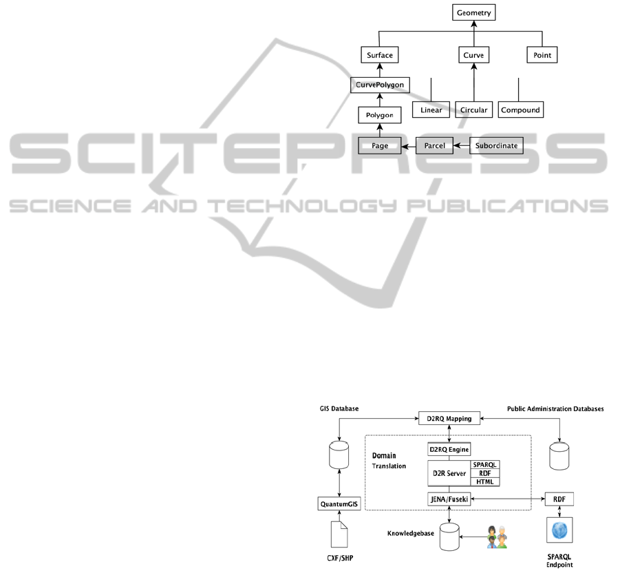
In order to define the ontologies needed in our
scenario, we selected the following identifiers:
Cadastral municipality, i.e., the municipality where
the property is located; Administrative Section, i.e., a
portion of the municipality; Page, i.e., a section of
the municipality that the Cadastre Registry
represents in its cartographic maps; Parcel, i.e., a
piece of land or building and any area of relevance
within the Page; Subordinate:, i.e., the UREU.
Generally, each UREU is identified by its own
subordinate, but, if the building is made up of a
single UREU, then the subordinate may be missing.
Considering the case of our interest and the
above cadastral data structure, we attached the
cadastral main entities (page, parcel, subordinate) to
the fundamental geometrical ontology, as shown in
fig.1, with the future goal of providing a wider
ontology scheme including other classes.
Figure 1: Geographic and cadastral entities.
2.2 Technologies
Since our aim is to expose RDF data structures
through a SPARQL endpoint, first we carried out the
data normalization of the original relational
database, and then we mapped these data in RDF
triples using the D2RQ Platform (http://d2rq.org),
that is an Open Source system that offers RDF based
access to the contents of the relational databases.
Fig.2 presents how users may query the RDF triple
store and the technologies involved in the
deployment of the proposed distributed architecture.
Figure 2: Overview of the multi-tier system architecture
and of the technologies adopted.
Each technology is a free and open source software
to allow the Public Administration to reduce running
expenses and maintenance costs. Also this choice
allows us to follow the cornerstone philosophy of
the Open Data movement, whose description is
given at http://opendefinition.org/.
ICEIS2013-15thInternationalConferenceonEnterpriseInformationSystems
358

As shown on the left of fig.2, our model suggests
that the data sources from the cadastral domain
should be converted from CXF format to shapefile;
then they are imported into Quantum GIS to be
exposed as vector drawings provided with geo-
referenced data.
These latter data, together with the public
administration data, are mapped through the D2RQ
Platform into RDF schemas in order to allow a
multi-tier querying by RESTful Web Services, RDF
marshalling and HTML/XHTML visualization.
A Jena/Fuseki framework is also contained into
the domain translation so that the above-mentioned
tiers may be attached to external RDF sources (such
as external SPARQL endpoints). The responses
provided to the users are stored in a knowledge base
to be used to speed up the future queries.
3 CASE STUDY
In this section we point out the main problems that
arise when one tries to implement the previous
architecture to provide in practice a specific e-
government service, i.e., the local estate taxation
depending on both personal data of the owners and
cadastral data of the real estate units.
3.1 Municipal Databases
The datasets about citizen and taxation were
provided by the local administration in the form of
IBM DB2 Databases. Therefore, before using the
D2RQ Platform these databases were converted into
MySQL databases to work on an open source
format. Then we selected the data of interest,
normalizing and exporting them into an additional
MySQL database. Finally the last step of the process
was the one of mapping the contents of the databases
into RDF triples through the on-the-fly translation
obtained by the above mentioned D2RQ Platform.
Although the above procedure seems easy,
several problems were encountered such as the lack
of semantics in the definition of the tables analysed
in this database. Indeed, it was made up of 58 tables
and 19,170,374 records containing many repetitions,
thus we have to cut off the tables to a large extent,
and to select only a subset of the data that would be
useful for the problem at hands.
Since the taxation process has to be applied to
citizens who own a property, only table rows
corresponding to estate owners were selected. Also,
only relevant columns of the above tables were
imported in a MySQL database, with the intent of
mapping them in RDF triples to be used for
supporting the taxation payment and checking using
SPARQL queries.
To this aim, we have carried out a connection of
the resulting municipal triple stores to the
information stored in the cadastral database, treating
the GIS data bases not as MySQL or PostGIS data
bases, but as a virtual RDF graph obtained using a
custom D2R mapping system, such as G2R (Della
Valle, 2010). Thanks to these structured semantic
connections we obtained a unique SPARQL
endpoint where it is possible to attach many kinds of
end-user application logic.
3.2 Cadastral Databases and GIS
Let us note that the cadastral datasets were provided
by the provincial Land Administration as an
extraction of the national cadastral map database
from WEGIS, that is a licensed closed source
powered by SOGEI http://www. sogei.it) and used
by the Italian Land Administration. In this extraction
each Page is represented by a pair of ASCII files: a
CXF file (Cadastral eXchange Format) containing
all the graphical elements that compose the cadastral
map, and a homonymous SUP file containing
statistical data and parcel surfaces.
Thus, a suitable conversion of the CXF and SUP
files should be done to store the cadastral
information within relational GISs that can be
interconnected to the municipal data, as suggested
in the previous section.
For this reason, these two files were converted
into ESRI shapefile, i.e., a geospatial vector data
format for geographic information system software
developed by ESRI using CXFToShape, i.e., a free
CXF to ESRI shapefile converter. Then, the
shapefile was imported into Quantum GIS, i.e., a
cross-platform free and open source GIS application
that provides capabilities of data visualization,
editing, and analysis and may be viewed as a virtual
RDF store using the mentioned D2R Platform.
Let us note that in this way we may use the
textual information contained in the Cadastre as
RDF triples, but for using the drawings in any GIS it
is necessary to represent them into a reference
system known by all the GISs available on the
market. Thus, we have geo-referenced the shapefile
imported into Quantum GIS by means of the
Cassini-Soldner geo-coordinate system through the
definition of a custom projection algorithm.
In this way the cadastral data may be processed
as triples and the vector drawings can be overlapped
to any raster data layers (Google Street Maps
AnOntologybasedApproachtoIntegrateDataandMaps-IntheGovernmentEnterpriseArchitecture:ACaseStudy
359
satellite, Bing Map Aerial layers and cartographic
regional data provided by Province Bureau) or
added to existing vector data layers (such as
OpenStreetMap, Google Streets and Bing Road).
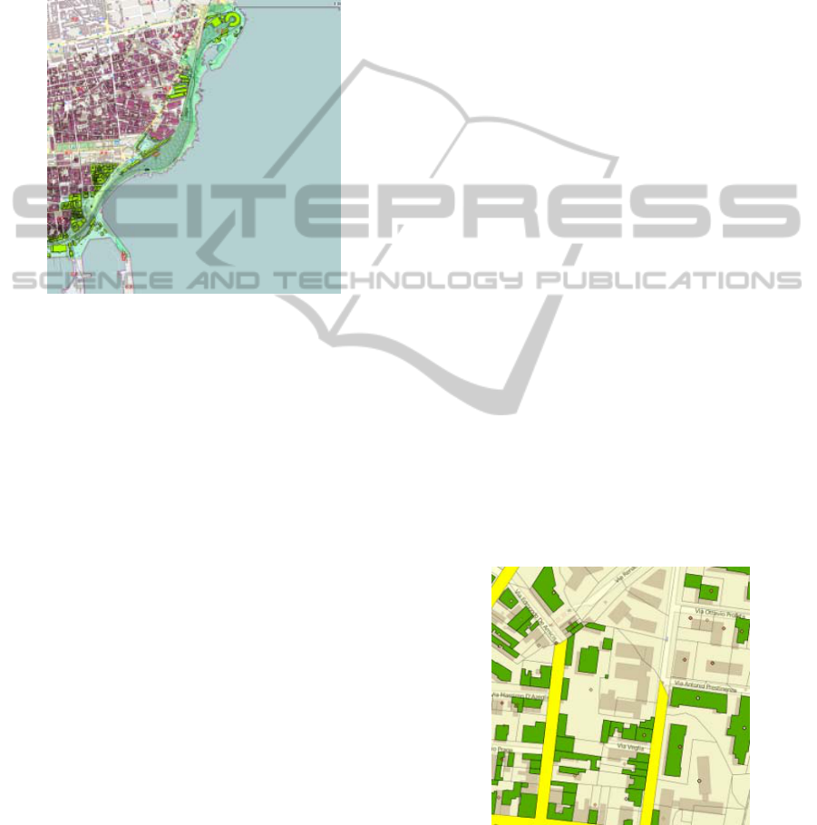
Fig.3 shows the perfect overlapping obtained in
Quantum GIS of the Cassini-Soldner layer dealing
with the coast area derived from the Cadastre over
the OpenStreetMap raster data layer.
Figure 3: Overlapping of the Cassini-Soldner layer over
the OpenStreetMap raster data layer.
This means not only that a SPARQL query may
allow us to join the municipal and cadastral data
using the relevant shared fields, e.g., the fiscal codes
of the owner or the UREU codes of the estates, but
also that the vector drawings of the cadastral entities
involved in the problem at hands (e.g., buildings,
roads, zones) may be represented in any GIS as
entities coloured depending on the theme. For
example, we may visualize on Google Maps in red
the buildings that contain commercial activities that
are in arrears if one is checking tax evasions, or in
yellow the roads that are not covered by regular
waste collection and in orange the downsized
schools if one is studying the quality of the services
offered to the citizens.
4 QUERYING E-GOV
DATA & MAPS
The semantic web gives to a developer two major
choices when using distributed databases for
querying in a semantic manner: the former is to copy
the entire amount of data in a unique knowledge
base, the latter is to perform a distributed query.
Each of them is affected by two disadvantages:
latency and scale, but for the Public Administrations
that have usually to manage large databases and big
amount of data, copying an entire data store is not
feasible. Thus in our approach we adopted the
distributed model already shown in fig.2 to allow the
users to query two or more RDF knowledge bases
using a formula expressed in SPARQL, or to
combine relational databases to be queried with a
D2RQ mapping language that translates the
SPARQL query to SQL on the fly. Fig.4 shows the
result of the following SPARQL query to obtain the
drawing of the buildings of an area whose centroid
returns, when clicked, the building tax payment
status:
SELECT ?Person ?Surname ?Name
?Street ?PropertyTaxReport ?Parcel ?Centroid
WHERE {
?Person a foaf:Person;
vocab:TaxpayerCode ?code;
foaf:lastName ?Surname;
foaf:firstName ?Name;
vcard:street-address ?Street .
?PropertyTaxReport a
vocab:propertyTaxReport;
vocab:TaxpayerCode ?code;
vocab:Page ?Page;
vocab:Parcel ?Parcel.
?Centroid a geo:point;
vocab:TaxpayerCode ?code;
vocab:Parcel ?Parcel .
FILTER (?Page = 8)
} ORDER BY ?Surname.
Let us note that the same result may be obtained by
executing the above query in either the former and
the latter scenario with similar performance. Better
performance may be achieved if the query may reuse
previous results stored on an RDF cache.
Figure 4: Results of the SPARQL query as a vector data
layer on Quantum GIS. The raster data is derived from
OpenStreetMap, the green polygons represent buildings,
the yellow highlighted sub-layers of the parcel represents
the streets. The points return, if clicked, geo-referenced
tax information.
ICEIS2013-15thInternationalConferenceonEnterpriseInformationSystems
360

5 CONCLUSIONS
Related works to the subject of the paper deal
mainly with cadastral system interconnection and
introducing spatial dimensions to RDF schemas.
An ontology architecture for the land
administration domain, targeted to achieving
semantic interoperability between cadastral systems
is proposed in (Bošković, 2010). The architecture
complies with both Geospatial and Land
Administration standards. An example of extension
dealing with the specificities of their national
cadastre is also provided. In (Hay, 2010), a Semantic
Web approach is proposed to customize applications
in the Land Administration Domain. Also, an OWL
layered architecture adaptable across jurisdictions is
outlined. Both these works differ from our proposal
in the conversion from relational data models to
ontology and in the presence of an explicit ontology
alignment step.
The work of introducing spatial dimensions to
the semantic web is described in (Auer, 2009) where
it is demonstrated how crowd sourced geographical
data transformed into RDF can be interlinked
(mapped) with other (spatial data) sets to enable
spatial data web applications. A similar work, i.e.,
(Della Valle, 2010) focuses explicitly on some
computational issues influencing the use of GIS
from the semantic web standpoint, and proposes to
treat GIS as virtual RDF graphs instead of re-
implementing GIS functionalities in semantic web
frameworks. This is achieved through an extension
of the D2RQ mapping language to include spatial
data types.
Therefore, the application scenario addressed in
this work, i.e., integration of cadastral systems with
citizen data, has not been tackled before.
Currently, the proposed ontology based
methodology to manage data and maps using RDF
schemas is being experimented in a project
promoted by the Sicily Region, named K-
metropolis, for supporting the municipal
Governments not only in defining the local taxation
policy but also in the transition from the current not
interoperable GIS platforms to the implementation
of a spatial data infrastructure to integrate data and
maps of different municipalities.
For example, we plan to support the municipal
Governments to define city master plans and civil
protection policies by interconnecting both public
and private data stores to the drawings derived not
only from the Cadastre but also from any relevant
institutional CAD system.
This will allow the municipal Government not
only to draw the intended land use and the
emergency plans over any raster background, such
as aerial photogrammetry or satellite images, but
also to represent these plans by a standard graphical
notation immediately understandable by any other
involved organization.
REFERENCES
Auer S., Lehmann J., Hellmann S., 2009. LinkedGeoData:
Adding a Spatial Dimension to the Web of Data, in A.
Bernstein et al. (Eds.): ISWC 2009, LNCS 5823
Bizer C., Heath T., Berners-Lee T., 2009. Linked data -
the story so far, Int. J. Semantic Web Inf. Syst.,
vol.5(3).
Baader F., Calvanese D., McGuinness D.L., Nardi D.,
Patel-Schneider P.F., 2003. The Description Logic
Handbook: Theory, Implementation, Applications,
Cambridge University Press, Cambridge, UK, 2003.
Boškovic D., Ristic A., Govedarica M., Przulj D., 2010,
Ontology Development for Land Administration”,
IEEE 8th Int. Symposium on Intelligent Systems and
Informatics, SISY.
Corlan M., 2009. Flash Platform Tooling: Flash Builder,
Adobe.
Costanzo A., Faro A., Giordano D., Venticinque M., 2012.
Wi-City: A federated architecture of metropolitan
databases to support mobile users in real time, Int.
Conf. on Computer and Information Science, ICCIS, A
Conference of World Engineering, Science and
Technology Congress, ESTCON.
Costanzo A., Faro A., Giordano D., 2013. WI-CITY:
living, deciding and planning using mobiles in
Intelligent Cities, 3
rd
International Conference on
Pervasive and Embedded Computing and
Communication Systems, PECCS, Barcelona,
INSTICC.
Crisafi A., D. Giordano D., C. Spampinato C., 2008.
GRIPLAB 1.0: Grid Image Processing Laboratory for
Distributed Machine Vision Applications, Proc. 17th
IEEE Int Conf on Enabling Technologies:
Infrastructure for Collaborative Enterprises, WETICE
’08, IEEE.
David M., 2011. Developing Websites with jQuery
Mobile, Focal Press.
Della Valle E., Qasim H.M., Celino I., 2010. Towards
Treating GIS as Virtual RDF Graphs. Proceedings of
the 1st International Workshop on Pervasive Web
Mapping, Geo-processing and Services, WebMGS.
Faro A., Giordano D., Musarra A., 2003. Ontology Based
Mobility Information Systems” Proc. of Systems, Men
and Cybernetics Conference, SMC’03, vol.3, 4288-
4293, IEEE.
Faro A., Giordano D., Spampinato C., 2008. Evaluation
of the Traffic Parameters in a Metropolitan Area by
Fusing Visual Perceptions and CNN Processing of
Webcam Images. IEEE Transactions on Neural
Networks, Vol. 19 (6), IEEE.
AnOntologybasedApproachtoIntegrateDataandMaps-IntheGovernmentEnterpriseArchitecture:ACaseStudy
361

Faro A., Giordano D., Spampinato C., 2011. Integrating
Location Tracking, Traffic Monitoring and Semantics
in a Layered ITS Architecture, Intelligent Transport
Systems, vol.5(3), IET.
Faro A., Giordano D., Spampinato C., 2011. Adaptive
background modelling integrated with luminosity
sensors and occlusion processing for reliable vehicle
detection”, IEEE Transactions on Intelligent
Transportation Systems, Vol.12(4)
Hartl M., 2011. Ruby on Rails 3, Addison Wesley.
Hay G:C., and G. B. Hall G.B., 2010. A Semantic Web
Approach to Application Configuration in the Land
Administration Domain, FIG Congress 2010 Facing
the Challenges - Building the Capacity Sydney.
Hayes. P., 2004. RDF Semantics. W3C Recommendation
10, Available on line at http://www.w3.org/TR/rdf-mt
Nebot. V., Berlanga. R., 2012. Building data warehouses
with semantic data, Decision Support Systems,
Vol.52(4). Available at http://sparql-wrapper.
sourceforge.net/.
Prud’hommeaux E., Seaborne A., 2008. SPARQL Query
1Language for RDF”, W3C Rec. 15.1.2. Available on
http://www. w3.org/TR/rdf-sparql-query/.
Saha P., 2010. Government Enterprise Architecture
Research Project, NUS Systems Science Inst.,
http://unpan1.un.org/intradoc/groups/public/document
s/unpan/unpan039390.pdf
Sheth, A., 2005. Enterprise applications of semantic web,
IFIP International Conference on Industrial
Applications of Semantic Web (IASW2005), Jyväskylä,
Finland.
Zhai, J., Jiang, J., Y. Yu, Y., Li J., 2008. Ontology-based
Integrated Information Platform for Digital City”,
IEEE Proc. of Wireless Communications, Networking
and Mobile Comp., WiCOM ’08.
ICEIS2013-15thInternationalConferenceonEnterpriseInformationSystems
362
