
Distributed Processing of Elevation Data by Means of Apache
Hadoop in a Small Cluster
Jitka Komarkova, Jakub Spidlen, Devanjan Bhattacharya and Oldrich Horak
Faculty of Economics and Administration, University of Pardubice, Studentska 95, 532 10 Pardubice, Czech Republic
Keywords: Distributed Processing, Apache Hadoop, Elevation Data, Small Cluster.
Abstract: Geoinformation technologies require fast processing of high and quickly increasing volumes of all types of
spatial data. Parallel computational approach and distributed systems represent technologies which are able
to provide required services, with reasonable costs. MapReduce is one example of such approach. It has
been successfully implemented in large clusters in several instances. The applications include spatial and
imagery data processing. The contribution deals with its implementation and operational performance using
only a very small cluster (consisting of a few commodity personal computers) to process large-volume
spatial data. Open-source implementation of MapReduce, named, Apache Hadoop, is used. The contribution
is focused on a low-price solution and it deals with speed of processing and distribution of processed files.
Authors run several experiments to evaluate the benefit of distributed data processing in a small-sized
cluster and to find possible limitations. Size of processed files and number of processed values is used as the
most important criteria for performance evaluation. Point elevation data were used during the experiments.
1 INTRODUCTION
Increasing volumes of stored and processed data is
today one of the important issues which must be
addressed by many types of information systems.
This issue is particularly very important for
geographic information systems and geoinformation
technologies in general, as far as the volumes of
spatial data are high and they are quickly increasing.
Elevation data is an example of large volume spatial
data. Parallel computational approach represents
a suitable way how to process large volumes of
spatial data at a reasonable time and shows how to
scale the processing.
Importance of parallelization was recognized by
Google several years ago. Google proposed
a suitable architecture able to handle high workload
and to improve web search applications performance
(Barroso et al., 2003). The proposed architecture
was oriented on throughput, software reliability and
reduction in costs. The idea was to use many
commodity-class personal computers (PC) together
with fault-tolerant software. At that time, Google
involved 15 000 commodity PCs. According to the
authors, this solution was more cost-effective than
utilization of a smaller number of high-end servers.
The solution was named MapReduce and it was
focused on general web search tasks connected to
web search like word frequency counting; on
processing of large volume data (e.g. terabytes) add
on utilization of large-scale distributed systems
based on commodity PCs (Barroso, et al., 2003;
Dean and Ghemawat, 2004).
After that, just a few ways of utilization of
MapReduce application for processing of spatial
data were proposed. Cary et al. (2009) proposed
a way of utilization of MapReduce to create R-Trees
and compute quality of aerial imagery. They used
Hadoop framework but it was run on Google & IBM
cluster which contained around 480 computers. Chu,
S.-T., Yeh, C.-C., Huang (2009) proposed creation
of trajectory index scheme based on Hadoop and
HBase as a part of StreetImage 2.0 service available
on a web site to all users. The main goal was to keep
response time of searching for trail logs (trajectories)
reasonable. An application model suitable for GIS
and based on cloud computing model was proposed
by Zhou, Wang, and Cui (2012). This model
includes Hadoop but no performance evaluation is
provided by the authors. Cardosa et al. (2012)
focused on optimization of MapReduce running in
cloud environment to achieve high utilization of
machines and decrease energy consumption by
340
Komarkova J., Spidlen J., Bhattacharya D. and Horak O..
Distributed Processing of Elevation Data by Means of Apache Hadoop in a Small Cluster.
DOI: 10.5220/0004591303400344
In Proceedings of the 8th International Joint Conference on Software Technologies (ICSOFT-EA-2013), pages 340-344
ISBN: 978-989-8565-68-6
Copyright
c
2013 SCITEPRESS (Science and Technology Publications, Lda.)
means of dynamically changing size of MapReduce
cluster. Zhu et al. (2009) focused on performance of
MapReduce in the case supercomputing applications
are run in its environment. They used 17 commodity
PCs. They identified a significant problem –
frequent data communication led to an overhead on
network.
2 IDENTIFIED ISSUES AND
GOALS
Authors use point elevation data, both regular grids
and LIDAR clouds, to create Digital Surface Models
(DSM). During the calculations they have
experienced significant problems with
computational performance of available hardware.
To improve the computational performance, they
decided to use distributed data processing powered
by several commodity PCs and run by an open-
source solution – Apache Hadoop which implements
MapReduce approach.
MapReduce programming model is proposed to
allow parallelized computing in a distributed system.
The solution allows automatic parallelization and
distribution of a computational task among available
nodes. It is implementable on large clusters of
commodity PCs, it enables scalability of the system
but it is able to provide high level of fault tolerance
at the same time. The idea of the programming
model is to split calculations into two stages: map
and reduce (Dean and Ghemawat, 2004). Apache
Hadoop is an open-source software which includes
MapReduce functionality together with Hadoop
Distributed File System (HDFS) and framework for
resource management (YARN). There are several
other modules and functionalities available too
(Apache, 2013).
Previous research on MapReduce and Hadoop
was more focused on large scale clusters and cloud
computational models where hundreds of computers
included into a cluster were used, e.g. Dean, and
Ghemawat (2004), Cary et al. (2009), Zhou, Wang,
and Cui (2012), Zhu et al. (2009). Several authors
pointed out the problem of high network load and
Dean and Ghemawat (2004) describe a possible way
of reducing amount of transmitted data through
network by partial summing of results of map tasks.
Another study was focused on optimization of
input/output performance of small files (size from 1
KB to 10 KB) which were published by means of
Web-based GIS application because HDFS was
proposed to store large files (Xuhui et al., 2009).
Contrary to these, authors focus on a purely
distributed solution which can be easily
implemented in small laboratory conditions, with
low costs and without utilization of a cloud service.
The main goal of this paper is to describe and
evaluate the proposed solution of utilization of
MapReduce approach for processing of elevation
data within a small-sized cluster consisting only of a
few commodity PCs. In this way authors extend the
previously done work.
3 DISTRIBUTED PROCESSING
IN A SMALL CLUSTER – CASE
STUDY
The proposed solution is based on Apache Hadoop
1.0.4. and Java 1.7. Ubuntu 12.10 is used as an
operating system running on all PCs. Design model
is simplified in comparison to the cloud GIS model
proposed by Zhou, Wang, and Cui (2012). Principle
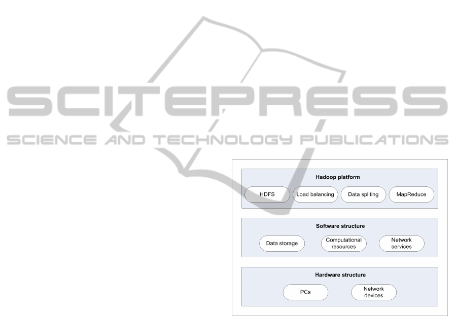
of the used model is shown in the Figure 1.
Figure 1: Design model of used solution.
3.1 Architecture
A very simple architecture is proposed. Only
5 commodity PCs are used. One of them works as
a master, the others as slaves. Configuration of PCs:
4 GB RAM, quad-core four-thread Intel® Core™
i3-3220 3.3 GHz CPU. All the computers are
connected by 100 Mbps Ethernet to a dedicated
VLAN (Virtual Local Area Network) within
university local network.
Used architecture and basic principles of
communication are shown in Figure 2. The principle
of communication is based on Hadoop properties
(Apache, 2013). Input data are stored in local data
storage. At first, data are split into blocks and
DistributedProcessingofElevationDatabyMeansofApacheHadoopinaSmallCluster
341
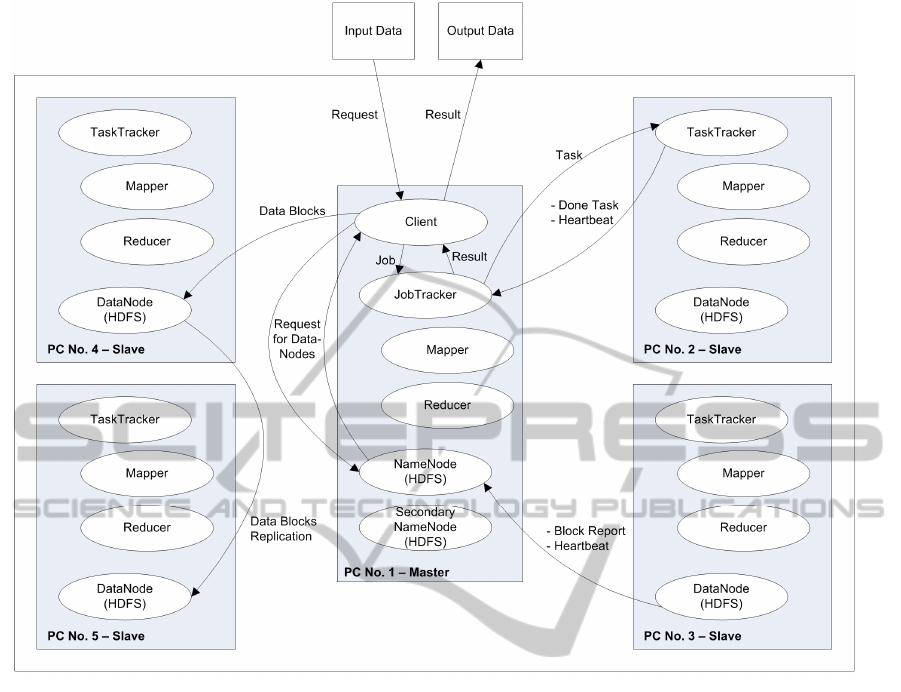
Figure 2: Architecture of used solution.
replicated to DataNodes. NameNode knows how
blocks of data are distributed within the cluster.
JobTracker is responsible for assigning
TaskTrackers specific computational tasks to be
solved. TaskTrackers regularly send heartbeat signal
(a special kind of a message that they are alive and
working properly) to let JobTracker know that they
are available for the next task. DataNodes do the
same, they send a heartbeat signal to the NameNode.
3.2 Data Processing
Point elevation data was used as input. Each record
represented one elevation point – its X, Y and Z
coordinates in text file containing 12 780 000
records, totalling 579 MB. Calculation was done for
38 340 000 values..
For the testing purposes splitting of input data was
se into the default value – 128 MB blocks.
Parameter “dfs.permission” was set to false to
prevent problems with read/write permissions.
The first experiment was focused on the
influence of number of PCs involved into the
cluster. Obtained results are shown in the Figure 3.
Number of reduce tasks is an important
parameter which can significantly influence
computational performance of the system. It is set by
the parameter “mapred.reduce.tasks” in the
configuration file of Hadoop. By default, number of
reduce tasks is set to 1 which means that reduce task
is not distributed. An appropriate increasing of the
reduce tasks can speed up the calculation.
Inappropriate number of reduce tasks can slower the
calculation because of increased network load (see
Figure 4). The same testing file was used as in the
previous step, so 38 340 000 values were processed.
An optimum number of reduce tasks can be
calculated according to the number of available
CPUs and cores. Increased number of reduce tasks
allows the free cores to begin with reduce tasks
before all map tasks are finished. It is recommended
to dedicate one core to daemon and the rest to map
and reduce tasks when there are more cores
available (Stein, 2010; Apache, 2013). According to
ICSOFT2013-8thInternationalJointConferenceonSoftwareTechnologies
342

Figure 3: Average processing time according to the
number of PCs included into cluster.
Figure 4: Average processing time according to the
number of reduce tasks.
Stein (2010) it is recommended to set the number of
reduce tasks: “somewhere between 0.95 and 1.75
times the number of maximum tasks per node times
the number of data nodes”. In our case, 5 nodes and
4 threads per node (Hyper-Threading Technology)
were available. It leads into an optimum interval
<15; 26> reduce tasks. For the next experiment we
set the parameter “mapred.reduce.tasks” to 15
because all of the used PCs were the same. Figure 5
shows processing times of bigger files containing
higher numbers of values. Figure 6 confirms that
map and reduce processes were partially run
parallely. Adding times of map and reduce processes
provides higher resulting time (Figure 6) than the
ones which were really measured (Figure 5).
To illustrate computational demandingness, the
same task was calculated using ArcGIS 10 for
Desktop. Used hardware was dual-core AMD
Opteron 8220 CPU, 48 GB RAM. In this case,
processing of the frequency calculation of Z
coordinate (elevation) took 36.3 min, without
Figure 5: Measured Processing Times of Bigger Files
Containing Higher Numbers of Values.
Figure 6: Processing Times of Bigger Files – Adding Map
and Reduces Times Together.
keeping data visible. Only 12 780 000 values were
processed by the tool “Frequency”. But the result
cannot be used for an exact comparison because of
different hardware. Yet it does point out and
demonstrate the difference in processing times.
4 CONCLUSIONS
Distributed data processing can significantly
improve computational performance and decrease
time needed to process data.
Authors deal with processing LIDAR data and
interpolation of digital surface models based on the
00:00
01:12
02:24
03:36
04:48
06:00
07:12
12345
Average processing time [min:s]
No. of PCs Included into Cluster
00:00
00:28
00:57
01:26
01:55
02:24
02:52
03:21
03:50
123456710205060100
Processing Time [min:s]
No. of Reduce Tasks
00:00
01:12
02:24
03:36
04:48
06:00
38.340.000 76.680.000 115.020.000
Time [min:s]
No. of Processed Values
00:00
01:12
02:24
03:36
04:48
06:00
38.340.000 76.680.000 115.020.000
Processing Time [min:s]
No. of Processed Values
Reduce
Map
DistributedProcessingofElevationDatabyMeansofApacheHadoopinaSmallCluster
343

LIDAR data in real time (Hovad et al., 2012). The
main aim of the authors is to propose a fast, easy and
less resource hungry solution to interpolate LIDAR
data and create 3D realistic surface models which
can be used e.g. by public administration authorities
or units of the Integrated Rescue System during
appropriate steps of crisis management.
The main goal of the paper is to describe
utilization of Apache Hadoop for processing of
elevation data in a small-sized cluster of commodity
PCs. Authors used only 5 PCs and partial steps are
completed successfully. Solution of these steps,
however, resulted in other issues which will be dealt
with as further research.
ACKNOWLEDGEMENTS
The Ministry of Interior partly supported this work,
by project VF20112015018. The Ministry of
Education, Youth and Sports of the Czech Republic,
projects CZ.1.07/2.3.00/30.0021 “Strengthening of
Research and Development Teams at the University
of Pardubice“, and CZ.1.05/4.1.00/04.0134
“University IT for education and research” partly
financially supported this work as well.
REFERENCES
Apache Software Foundation, Welcome to Apache™
Hadoop®! (online), 2013. [cit. 2013-06-04]. URL: <
http://hadoop.apache.org/index.html>.
Barroso, L. A., Dean, J., Holzle, U., 2003. Web search for
a planet: The Google cluster architecture, IEEE
MICRO, 23 (2), 22-28.
Cardosa, M. et al., 2012. Exploiting Spatio-Temporal
Tradeoffs for Energy-Aware MapReduce in the Cloud,
IEEE Transactions on Computers, 31 (12), 1737-1751.
Cary, A. et al., 2009. Experiences on Processing Spatial
Data with MapReduce, In Scientific and Statistical
Database Management, Proceedings, Lecture Notes in
Computer Science, vol. 5566, 302-319. Springer-
Verlag.
Chu, S.-T., Yeh, C.-C., Huang, C.-L., 2009. A Cloud-
Based Trajectory Index Scheme, In ICEBE 2009:
IEEE International Conference on E-Business
Engineering, Proceedings, 602-607. IEEE.
Dean, J., Ghemawat, S., 2004. Map Reduce: Simplified
data processing on large clusters, In OSDI'04
Proceedings of the 6th conference on Symposium on
Opearting Systems Design & Implementation -
Volume 6, 137-149.
Hovad, J. et al., 2012. Data Processing and Visualisation
of LIDAR Point Clouds. In Proceedings of the 3
rd
International conference on Applied Informatics and
Computing Theory (AICT '12), 178-183. WSEAS
Press.
Stein, J., 2010. Tips, Tricks And Pointers When Setting
Up Your First Hadoop Cluster To Run Map Reduce
Jobs (online). URL: <http://allthingshadoop.com/
2010/04/28/map-reduce-tips-tricks-your-first-real-
cluster/>.
Xuhui L. et al., 2009. Implementing WebGIS on Hadoop:
A case study of improving small file I/O performance
on HDFS. In Proceedings of the 2009 IEEE
International Conference on Cluster Computing,
August 31 - September 4, 2009, New Orleans,
Louisiana, USA, 1-8. IEEE.
Zhang C. et al., 2010. Case Study of Scientific Data
Processing on a Cloud Using Hadoop. In High
Performance Computing Systems and Applications,
Lecture Notes in Computer Science, 5976, 400-415.
Springer-Verlag.
Zhou, L. L., Wang, R. J., Cui, C.Y., 2012. GIS
Application Model Based on Cloud Computing,
Communications in Computer and Information
Science: Network Computing and Information
Security, 345, 130-136.
Zhu, S. et al., 2009. Evaluating SPLASH-2 Applications
Using MapReduce, Advanced Parallel Processing
Technologies, Proceedings, Lecture Notes in
Computer Science, 5737, 452-464. Springer-Verlag.
ICSOFT2013-8thInternationalJointConferenceonSoftwareTechnologies
344
