
A Future of Traffic Management
Toward a Hybrid System of Roadside and Personal Mobile Devices
Tom Thomas
Center of Transport Studies, University of Twente, p.o.box 217, 7500 AE Enschede, The Netherlands
t.thomas@utwente.nl
Keywords: Travel Time, Travel Demand, Urban, Prediction, Detection Loops, GPS.
Abstract: In the last few decades, increasing traffic has led to serious problems in urban areas. Travel times for
travellers have increased and the liveability in residential areas has declined due to pollution and issues
concerning safety. Whereas new road and rail infrastructure in densely populated areas is costly, a better
utilisation of existing infrastructure appears to be more attractive. This becomes increasingly possible due to
huge developments in the world of Information and Communication Technology (ICT). However,
implementing ICT solutions for the purpose of traffic management remains challenging. First, it is quite a
task to set up a system in which infrastructure, travel vehicles and travellers can communicate with each
other. Secondly, it is quite difficult to gather and exchange traffic and travel information in such a way that
the traffic situation improves significantly. This paper deals with the latter issue, and it provides an outline
for the possible architecture of a future traffic management system. It concludes that in such a system both
mobile devices, like smartphones and navigation systems, and roadside devices, like loop detectors and
cameras, need to be included to arrive at optimal results.
1 INTRODUCTION
Congestion has increased significantly in the last
few decades. The efficient use of existing
infrastructure by dynamic traffic management
(DTM) is one of the strategies to reduce congestion
and related problems like air pollution. An important
requirement is the availability of detailed traffic
information such as travel demand and travel times.
In the Netherlands and many other developed
countries, highway data are collected by a high
concentration of detection loops which yield
information on traffic intensities and travel times. In
urban areas traffic information is much scarcer and
only since quite recently, traffic data gathered by
roadside devices like detection loops have become
available in traffic information centres (e.g., Hasberg
and Serwill, 2000, Kellerman and Schmid 2000,
Leitsch, 2002). For urban areas, the traffic
circulation is usually estimated by a combination of
intensity measurements and traffic models.
However, with new measurement methods by which
individual vehicles are identified (Blokpoel and
Vreeswijk, 2011), accurate roadside measurements
of travel times and routes will become possible.
At the same time, the use of mobile sensor data
such as GPS and GSM has been increasing rapidly,
which have led to separate travel time estimators
(e.g., Google Traffic, 2013). Because these data are
gathered by personal devices such as navigation
systems and smartphones, travel information and
advice can be personalized and adapted to the
preferences of the individual traveller (e.g., Bie et
al., 2012). In case of smartphones, travel information
does not have to be limited to car trips, but may also
include several other travel modes.
Roadside and mobile sensor data techniques both
have their specific strengths. In this paper, a possible
architecture for future DTM is put forward in which
both data sources are combined at some point. In
section 2, the requirements for a future DTM system
are provided. Then, in section 3 and 4, the
advantages, disadvantages and possibilities of
mobile and roadside sensor data are described
respectively. Based on the requirements for a future
DTM system and the strengths and weaknesses of
roadside and mobile sensor data, section 5 describes
an outline for the architecture of a possible future
DTM system.
271
Thomas T.
A Future of Traffic ManagementToward a Hybrid System of Roadside and Personal Mobile Devices.
DOI: 10.5220/0004776402710277
In Proceedings of the Third International Symposium on Business Modeling and Software Design (BMSD 2013), pages 271-277
ISBN: 978-989-8565-56-3
Copyright
c
2013 by SCITEPRESS – Science and Technology Publications, Lda. All rights reserved

2 DTM REQUIREMENTS
The requirements for a modern DTM system should
be based on two pillars. First, the traffic system,
usually the responsibility of a traffic manager,
should run smoothly. This may mean several things,
but in general the objective is to minimize the total
delay on the (road) network and to minimize
external costs caused for example by traffic
accidents or air pollution. Secondly, the traffic users,
i.e. travellers, want to travel smoothly. This may
also mean various things for individual travellers,
but in general travellers want to minimize their
(perceived) travel time and cost while perceiving the
journey as being safe and comfortable.
In other words, the traffic manager’s objective is
to optimize the traffic system as a whole, while
travellers want to optimize their individual journeys.
Both things are not necessarily resulting in the same
traffic equilibrium, and in some cases they are even
clearly conflicting with each other. One of the main
challenges of a modern DTM is therefore to
reconcile the two.
Meeting the objectives of the traffic manager and
individual traveller also requires different
information needs. An individual traveller needs to
have traffic information about the possible travel
modes and routes that are relevant to him, i.e. those
that can be used to reach the preferred destination.
Detailed information only needs to be available
during the time of traveling. This is by no means
trivial, because it still requires a prediction of the
traffic situation in the near future, i.e. until the
journey is expected to be completed.
However, this task is relatively easy compared to
optimizing management objectives. Whereas the
individual traveller is merely influenced by
surrounding traffic, the traffic manager is
influencing traffic itself, which effects are much
harder to predict. Moreover, the effects of traffic
operations like traffic lights are not necessarily
instantaneous, but may show delays. For example, a
traffic measure in one part of a city can have an
effect in another part half an hour later. In the ideal
case, the traffic situation should therefore be
predictable for the whole network, for different
traffic management scenarios, and during a longer
period of time, for example a whole peak hour.
Fulfilling the needs of individual travellers on
the other hand has its own challenges. While there is
one traffic manager with one set of objectives, there
are many individual travellers, all with their own
perceptions, preferences and habits that play an
important role in the decision making process. In
this modern individual oriented society, traffic
information and travel advice of one fits all is
becoming less acceptable. By using individual
devices like smartphones, it is also becoming
technically possible to provide personalized traffic
information and travel advice.
From the aforementioned considerations, one
can arrive at the following requirements:
1. Traffic management requires accurate
predictions about the traffic situation for the
whole network, different traffic management
scenarios and whole (peak) periods.
2. Individual travellers need personalized multi-
modal travel advice based on their preferences
and habits.
3. A traffic management measure should not lead to
the perception of travellers that they are worse
off due to the measure or are harmed unfairly by
it.
The third requirement tries to reconcile differences
between the interests of traffic manager and
individual travellers. Of course, it is impossible to
satisfy all travellers. However, it might be possible
to introduce measures such that travellers do not
notice they are worse off and therefore do not
change their behaviour, or such that travellers do not
perceive the alternative they switch to as worse or
unfair.
3 MOBILE SENSOR DATA
Mobile sensors like GPS and GSM are widely used
in smartphones and navigation systems nowadays.
Initially, they were used for navigation, but as their
numbers increase, they are now also being used for
estimating travel times on road trajectories (e.g.,
Google Traffic, 2013). There are however more
applications: they can reveal travel patterns of
individuals and groups of travellers.
In most countries, including the Netherlands, the
understanding of people’s travel behaviour is based
on cross-sectional travel surveys where in general
only one day is surveyed for each respondent in
representative periods (Ortuzar et al., 2010). From
these data, origin destination matrices, modal split
(mode choice) and route choice are estimated and
used in models that model urban traffic flows.
However, this is not enough to gain a proper
understanding of the dynamics in travel behaviour.
More specific, cross-section data do not give any
information to ascertain how choices will vary over
Third International Symposium on Business Modeling and Software Design
272

time (i.e. policy response) if the system changes.
Studies with GPS-devices show a strong variation in
multi-day travel behaviour (e.g., Stopher amd
Zhang, 2011). People are shown to visit new places
even after several months of monitoring
(Schönfelder and Axhausen, 2010). Apart from
determining destination and mode choice patterns
over longer periods of time, GPS data are
increasingly used to study route choice (e.g., Jan et
al. 2000, Zhu and Levinson 2009, Papinski and Scott
2011).
Derived from standard economics it is often
assumed in transport modeling that travelers are
rational decision makers and have perfect
knowledge on all available choice alternatives.
There is increasing recognition that these
assumptions are debatable. In reality, people may
have limited knowledge and constrained cognitive
abilities, leading to prejudiced reasoning and
seeming randomness in choice behavior (e.g.
Avineri and Prashker, 2004). This has been
described as bounded rationality or satisficing
behavior, first introduced by Herbert Simon (Simon,
1955) , and also found its way into transportation
research (Mahmassani and Chang, 1987,
Jayakrishnan et al., 1994). Since then, multiple
studies suggested that these irrational behaviors are
neither random nor senseless; they are systematic,
consistent, repetitive, and therefore predictable
(Tversky and Kahnemann, 1981, Ariely, 2009).
A well-known mechanism derived from the
principles of bounded rationality is the notion of
indifference band (Mahmassani and Chang, 1987).
According to the theory of indifference bands,
drivers will only alter their choice when a change in
the transportation system or their trip characteristics,
for example the travel time, is larger than some
individual-situation-specific threshold.
More in general, travelers appear to make their
decisions based on their perception of alternatives,
which is biased according to the ‘choice-supportive
bias’. That is, people are more likely to attach
positive feeling to options they choose and attribute
negative features to options they reject (Mather et
al., 2003, Henkel and Mather, 2007) even if that
would be irrational. In terms of travel choices this
suggests that travelers have different perceptions of
options they frequently use than options they hardly
use (Vreeswijk et al. 2013).
These findings may play an important role in
future DTM, especially in fulfilling requirements 2
and 3. Although some travelers may be worse off
when the overall network performance is optimized,
it may be possible to choose DTM measures for
which travelers do not perceive they are worse off or
do not find this a problem. This will only be
possible, however, when travelers get personalized
travel advice based on their preferences and habits.
For this, mobile sensor data appear to be
indispensable.
4 ROADSIDE DEVICES
The use of smartphone, carrying among others a
GPS-sensor, will probably rise in the coming years,
enabling new data acquisition opportunities
(Stopher, 2009, Nitsche et al., 2012). In addition,
there already are numerous smartphone applications
gathering personal travel data (e.g. UbiActive (Fan
et al. 2012), Trip Analyzer (Li et al., 2011), and
tripzoom (Bie et al., 2012)). Finally, smartphones or
navigation devices are used as probes to estimate
travel times on main roads. The question thus arises
whether roadside devices are still necessary in the
future.
To answer this question, we need to consider
requirement 1 from section 2: “Traffic management
requires accurate predictions about the traffic
situation for the whole network, for different traffic
management scenarios and over whole (peak)
periods”.
This requirement implies several things at the
same time. First, information is needed on the traffic
situation. This is much more than travel time alone.
Policy makers are not only responsible for travellers,
but also for the environment that is harmed by
traffic. Pollution, noise hindrance and safety are
important external factors which need to be
considered, especially in dense residential areas or
near locations that attract vulnerable groups such as
schools. This implies that certain vulnerable, busy or
economically important areas, locations or corridors,
may need to be monitored continuously. Because
many external effects depend on traffic intensity,
this important quantity should be included in the
monitoring.
Secondly, predictions are required for the whole
network under various (possible) management
scenarios. This implies that traffic intensities and
travel times should be predictable when the traffic
manager decides to increase or reduce the capacity
of certain roads (for example by giving more or less
green time). Because travel time shows a strong non-
linear dependence on network intensities (demand)
and capacities (supply), it is difficult to predict travel
time when intensities and capacities are unknown,
especially when small changes in intensity have a
A Future of Traffic Management: Toward a Hybrid System of Roadside and Personal Mobile Devices
273

large effect on travel time. This is actually the case
when it matters (i.e. in urbanized areas with a lot of
traffic), while at the same time intensities are known
to show strong variation within days and between
days (Thomas et al., 2008). Accurate travel time
predictions under varying (management) scenarios
are therefore only possible when network demand
and supply are predictable.
From this, it can be concluded that traffic
management requires continuously monitoring of
travel times, traffic intensities and capacities
throughout the network or at least at, in or along
important locations, areas or corridors.
At the moment this is not possible with mobile
sensors. Mobile sensor (GPS) samples for public use
are simply much too small. This may be changing
(e.g. Rieser-Schüssler et al. 2012) somewhat, but the
expectation is that, in general, public GPS samples
will remain limited, (partly) due to privacy
restrictions and commercial interests. In other
words, large amounts of mobile sensor (GPS) data
may remain out of reach for traffic management.
Even if mobile sensor data would increase
substantially for public use, there will always be
some travelers missing from the data. For example,
commuters will be less inclined to use navigation.
Therefore, it can be questioned whether there will
ever be enough mobile sensor (GPS) data to monitor
traffic intensities and capacities of the important
road sections with enough accuracy.
Roadside observations can fill this gap. In urban
areas, single detection loops have long been used to
measure occupation levels and intensities as input
for traffic light operations. Network monitoring is
more difficult with these data, because delays cannot
easily be estimated in saturated conditions (when
queues form near traffic lights), and individual
vehicles cannot be followed through the network. As
a result these measurements don’t provide
information on OD patterns and routes.
However, this is changing due to increasing use
of cameras and new induction detection techniques
that enable the identification of individual vehicles
(Blokpoel and Vreeswijk, 2011). Thus, with these
roadside devices located at important intersections,
travel times, intensities and capacities can be
measured directly throughout the network. Together
with prediction algorithms like neural networks
(e.g., Dharia, and Adeli, 2003, Yin et al. 2002),
pattern matching models (e.g., Bajwa et al., 2004),
extrapolation models (e.g., Wild , 1997, Chrobok et
al., 2004, Thomas et al., 2009) or clustering models
(e.g., Chung, 2003, Weijermars, 2007), more
accurate traffic predictions of intensities and travel
times will then become possible given certain
management scenarios.
5 SYNTHESIS
As we have seen in the previous sections, traffic
managers and travelers use different devices, i.e.,
roadside and mobile devices respectively, to acquire
traffic information. Although mobile devises like
smartphones with GPS become increasingly
important, roadside devices might remain the main
source of information for traffic management,
because besides travel time they are able to provide
accurate information on intensities and capacities.
The traditional use of traffic information by
policy makers and travelers as shown in Figure 1
therefore remains quite realistic. The Figure shows
two independent symmetric systems for both traffic
management and the individual traveler. Both
systems have objectives, i.e., policy objectives for
the traffic manager and travel objectives for the
traveler. By confronting these objectives with traffic
and travel information respectively, traffic
operations are set to manage the traffic system, and
travel decisions are made to execute a trip. The
traffic information is derived from data from
roadside sensors, while travel information is derived
from mobile sensor data.
Of course this Figure is a simplistic illustration
of reality. The division between the use of roadside
and mobile sensors is in reality not this strict, and a
single box could in itself represent a complicated
process with feedback loops. Traffic operations, for
example, represent an interplay between
instruments, such as traffic lights, variable message
signs or route guidance panels, and traffic managers,
while travel decisions may include more than only
the traveller’s behaviour. In fact, nowadays most
travellers are assisted by travel apps that provide the
traveller with information or advice. Travel apps are
therefore implicitly included in travel decisions. The
use of travel information in travel apps is more
subtle than the figure indicates. Mobile sensor data
of other users are used to provide reliable
information on relevant travel modes and routes,
while historical travel choices of the user may be
used to personalize the advice. However, for the
broader picture, these issues do not need to be
considered in detail here.
The weak part of the traditional concept, as
illustrated by Figure 1, is the lack of any interaction
between traffic management and traveller. This leads
to drawbacks regarding all three DTM requirements.
Third International Symposium on Business Modeling and Software Design
274
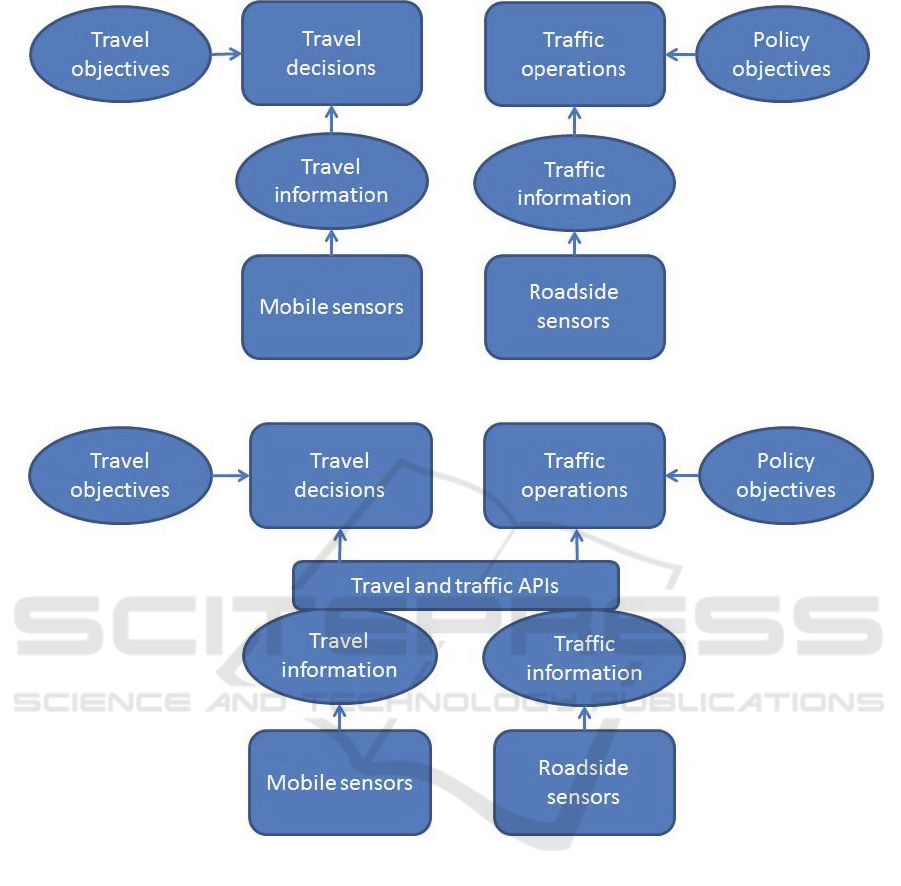
Figure 1: scheme of traditional use of mobile and roadside sensors.
Figure 2: Scheme of integrating traffic and individual travel information on an operational level.
Surely, the usefulness of advice to the traveller
would be enhanced by knowledge about (future)
traffic operations (requirement 2). By the same
token, the quality of traffic prediction would be
increased when the intentions or likely future
decisions of individual travellers are known to the
traffic manager (requirement 1). Finally, without any
interaction, there is no knowledge about (a change
in) travellers’ perceptions regarding certain traffic
management measures (requirement 3).
In some projects such as SUNSET (Sunset, 2013)
and I-zone (Veenstra et al., 2010), the information
from travellers (mobile sensors) and traffic operators
(roadside sensors) have been combined. This is
shown schematically in Figure 2. Again, the
architecture is more complicated in reality, and both
projects comprise much more than combining
different data sources. However, the general use of
data in these projects is well captured by Figure 2.
Information derived from roadside and mobile
sensor data are combined in one large database.
Third parties, mostly private companies, can retrieve
this information via APIs, and can use this
information in all kinds of apps they develop for
travellers.
The main characteristic of such an architecture is
sharing of underlying sensor data, and providing
these data to the larger public. However, there are
two main drawbacks of such an architecture
regarding DTM. First, travel information on such
A Future of Traffic Management: Toward a Hybrid System of Roadside and Personal Mobile Devices
275
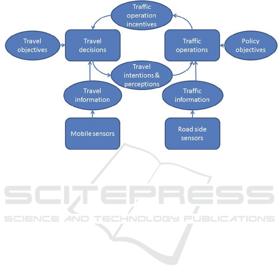
Figure 3: Scheme of integrating traffic and individual travel information on a strategic level.
an operational level is sensitive (regarding privacy)
and is also regarded as quite valuable by companies
that gather the data. It is therefore not very likely
that these important players are willing to share their
data. Secondly, these operational data do not provide
the intentions of traffic operators and travellers. In
fact, the main difference between roadside and
mobile sensor data is not that they necessarily
measure very different things (although not exactly
the same either), but that they are used by very
different users and for very different purposes. The
real strength of sharing information would be on a
higher, strategic, level such as shown in Figure 3.
In Figure 3, there is directly feedback between
traffic operations and travel decision making. Based
on traffic information from roadside devices and
traffic policies, traffic operations are set to manage
the traffic (such as in Figure1). However,
information about travellers’ reactions to and
perceptions of certain management measures are
provided to the traffic operators and are used to
improve the management scenarios. At the same
time, updated management scenarios are provided to
travellers(’ apps), enabling travellers to take specific
traffic measures (including possible incentives for
favourable behaviour) into account when planning
their trip.
Instead of sharing traffic data, the main
characteristic of this DTM vision is sharing of
intentions, plans and measures between traffic
operators and travellers. The corresponding
architecture would connect well to the DTM
requirements mentioned in section 2. The question
would then be: what kind of information is exactly
shared and how is this information shared? Should
the information include detailed operational data
such as green times of individual traffic lights given
specific inflow intensities, or should the information
be provided on a more aggregated and strategic
level? To answer these questions follow up research
is needed, preferably in a European project with as
main aim to develop such a future DTM system for
main European cities.
REFERENCES
Ariely, D., 2009. Predictably Irrational - Revised and
expanded edition. London: HarperCollingsPublishers.
Avineri, E., Prashker, J. N., 2004. Violations of expected
utility theory in route-choice stated preferences,
Transportation Research Record, vol. 1894, pp. 222-
229.
Bajwa, S. I., Chung, E., Kuwahara, M., 2004. An adaptive
travel time prediction model based on pattern
matching, In 11
th
World Congress on Intelligent
Transport Systems, Nagoya, Japan.
Bie, j., Bilsma, M., Broll, G., Cao, H., Hjalmarsson, A.,
Hodgson, F., Holleis, P., Van Houten Y., Jacobs, K.,
Koolwaaij, J., Kusumastuti, D., Luther, M., 2012.
Move Better with tripzoom, International Journal on
Advances in Life Sciences, vol. 4, no. 3&4, pp. 125 –
135
Third International Symposium on Business Modeling and Software Design
276

Blokpoel, R., Vreeswijk, J., 2011. Vehicle inductive
profile for incident detection, In Proceedings of the
18th World Congress on Intelligent Transport
Systems, Orlando, United States.
Chrobok, R., Kaumann, O., Wahle, J., Schreckenberg, M.,
2004. Different methods of traffic forecasting based on
real data, European Journal of Operational Research,
vol. 155, pp. 558-568
Chung, E., 2003. Classification of traffic pattern,In
Proceedings of 10
th
World Congress on Intelligent
Transport Systems, Madrid.
Dharia, A., Adeli, H., 2003. Neural network model for
rapid forecasting of freeway link travel time,
Engineering Applications of Artificial Intelligence,
vol. 16, pp. 607-613.
Fan, Y., Chen, Q., Douma, F., Liao, C.-F., 2012.
Smartphone-Based Travel Experience Sampling and
Behavior Intervention among Young Adults.
Intelligent Transportation Systems Institute, Center for
Transportation Studies, University of Minnesota.
Google Maps. Maps.google.com Accessed: 2013
Hasberg, P., Serwill, D., 2000. Stadtinfoköln – a global
mobility information system for the Cologne area, In
7
th
World Congress on Intelligent Transport Systems,
Turin, Italy.
Henkel, L. A., Mather, M., 2007. Memory attributions for
choices: How beliefs shape our memories, Journal of
Memory and Language, vol. 57, pp. 163-176.
Jan, O., Horowitz, A.J., Peng, Z.R., 2000. Using global
positioning system data to understand variations in
path choice. Transportation Research Record, vol.
1725, pp. 37-44.
Jayakrishnan, R., Mahmassani, H. S., Hu, T. Y., 1994. An
evaluation tool for advanced traffic information and
management systems in urban networks,
Transportation Research Part C, vol. 2, pp. 129-147.
Kellerman, A., Schmid, A., 2000. Mobinet: Intermodal
traffic management in Munich –control centre
development, In 7
th
World Congress on Intelligent
Transport Systems, Turin, Italy.
Leitsch, B., 2002. A Public-privat partnership for mobility
– Traffic management Center Berlin, In 9
th
World
Congress on Intelligent Transport Systems, Chicago,
USA.
Li, M., Dai, J., Sahu, S., Naphade, M., 2011. Trip analyzer
through smartphone apps, In Proceedings of the 19th
ACM SIGSPATIAL International Conference on
Advances in Geographic Information Systems, ACM,
537-540.
Mahmassani, H. S., Chang, G.-L., 1987. On boundedly
rational user equilibrium in transportation networks,
Transportation Science, vol. 21, pp. 89-99.
Mather, M., Shafir, E., Johnson, M. K., 2003.
Remembering chosen and assigned options, Memory
and Cognition, vol. 31, pp. 422-433.
Nitsche, P., Widhalm, P., Breuss, S., Maurer, P., 2012. A
Strategy on How to Utilize Smartphones for
Automatically Reconstructing Trips in Travel Surveys.
Procedia - Social and Behavioral Sciences, vol. 48,
pp. 1033-1046.
Ortúzar, J. D. D., Armoogum, J., Madre, J.-L., Potier, F.,
2010. Continuous Mobility Surveys: The State of
Practice. Transport Reviews, vol. 31, pp. 293-312.
Papinski, D., Scott, D.M., 2009. A GIS Toolkit for route
choice analysis, Journal of Transport Geography, vol.
19, pp. 434 – 442.
Rieser-Schüssler, N., Balmer, M., Axhausen, K.W., 2012.
Route choice sets for very high-resolution data,
Working paper Transport and Spatial Planning, EHT,
Zürich, Switzerland
Schönfelder, S., Axhausen, K. W., 2010. Urban Rhythms
and Travel Behaviour. Spatial and Temporal
Phenomena of Daily Travel, Farnhem/Burlington,
Ashgate Publishing.
Simon, H. A., 1955. A behavioural model of rational
choice, Quarterly Journal of Economics, vol. 69, pp.
99-118.
Stopher, P. R., 2009. The travel survey toolkit: where to
from here? Transport survey methods, keeping up with
a changing world, pp. 15-46.
Stopher, P.R., Zhang, Y., 2011. The repetitiveness of daily
travel, Transportation Research Board Annual
Meeting, Washington DC, USA.
Sunset, http://sunset-project.eu/ Accessed: 2013
Thomas, T., Weijermars, W. A. M., Van Berkum, E. C.,
2008. Variations in urban traffic volumes, European
Journal of Transport and Infrastructure Research, vol.
8. no. 3, pp. 252-264.
Thomas, T., Weijermars, W. A. M., and Van Berkum, E.
C., 2010. , IEEE transactions on intelligent transport
systems, vol. 11, no. 1, pp. 71-80.
Tversky, A., Kahnemann, D., 1981. The framing of
decisions and the psychology of choice, Science, vol.
211, pp. 453-458.
Veenstra, S.A., Teeuw, W.B., Meeuwissen, M., 2010.
Incentive Zone Enschede; Het verleiden tot
gedragverandering op basis van gepersonaliseerde,
multi-modale mobiliteitsinformatie en –advies,
Colloquium Vervoersplanologisch Speurwerk (CVS
2010), Roermond, The Netherlands.
Vreeswijk, J. D., Thomas, T., Van Berkum, E. C., Van
Arem, B., 2013. Drivers' perception of route
alternatives as indicator for the indifference band. In
Proceedings of 92th Annual Meeting of the
Transportation Board, Washington DC, USA.
Weijermars , W. A. M., 2007. Analysis of urban traffic
patterns using clustering, Ph.D. Thesis, University of
Twente, Enschede, The Netherlands.
Wild, D., 1997. Short-term forecasting based on a
transformation and classification of traffic volume
time series, International Journal of Forecasting, vol.
13, pp. 63-72.
Yin H., Wong, S. C., Xu, J., Wong, C. K., 2002. Urban
traffic flow prediction using a fuzzy-neural approach,
Transportation Research Part C, vol. 10, pp. 85-98.
Zhu, S., Levinson, D., 2010. Do people use the shortest
path? An empirical test of Wardrop’s first principle, In
Conference proceedings of the 4th International
Symposium on Transportation Network Reliability,
Minneapolis, USA.
A Future of Traffic Management: Toward a Hybrid System of Roadside and Personal Mobile Devices
277
