
GIS-based Backcasting
A Method for Parameterisation of Sustainable Spatial Planning and Resource
Management
Eva Haslauer
1
, Thomas Blaschke
1
and Markus Biberacher
2
1
Interfaculty Department of Geoinformatics, University of Salzburg, DK GIScience, Schillerstraße 30, 5020 Salzburg,
Austria
2
Research Studios Austria, Studio iSPACE, Schillerstraße 25, 5020 Salzburg, Austria
1 ABSTRACT
Backcasting, if used as a decision support and
planning method, starts from a desired future state or
vision and simulates backwards until present time.
During the model run, which goes backwards in
time, development paths are created. They expose
which steps have to be taken in future to reach the
desired state. Besides, milestone scenarios are
created as outputs that represent interim goals.
The paper at hand proposes an automated, GIS-
based backcasting model, since backcasting so far
has only been applied in workshops or as theoretical
framework. Until now no spatially explicit
backcasting model has been set up. The proposed
backcasting model first creates a future scenario
utilizing an Agent Based Model approach.
Afterwards the model simulates backwards
implemented as a Cellular Automaton. This is
realized in a Python script and linked to the Open
Source GIS software Quantum GIS.
The general model is applied to a case study in
Salzburg, Austria. The topic concerns sustainable
spatial planning. The results of the model run show
in time steps a successful backcasting of land-use
classes from a future state back until present time.
2 STAGE OF THE RESEARCH
The preliminary title of my PhD work is ‘A GIS-
based Backcasting: An innovative method for
parameterisation of sustainable spatial planning and
resource management’. I started my PhD in
February 2011 and I am now in the final year. In
September 2011 I joined the Doctoral College
GIScience at the University of Salzburg which
provides a professional and excellent network of
students and faculty for potential collaborations and
knowledge exchange.
The initially defined research questions of my
PhD work are:
1. Can backcasting exercises be reasonably
translated into models?
a. Which options could be used?
2. Are Geosimulation tools applicable to a
backwards working approach like backcasting?
b. Can Cellular Automata and/or Agent Based
Models be used?
I meanwhile published one PhD-relevant article
in the ISI-referenced journal Futures. Its title is
similar to my PhD topic, namely ‘GIS-based
Backcasting: An innovative method for
parameterisation of sustainable spatial planning and
resource management’ and was published online in
November 2011. This paper covers the first ideas
and a theoretical framework of the backcasting
model. Since then I was working on the
implementation of the backcasting model itself,
which is now in the final stage.
Currently I am working on my second PhD
relevant article which is supposed to be submitted in
July to the journal ‘Environmental modelling &
software’. It presents the implementation of the
model and development steps towards the spatially
explicit model.
3 OUTLINE OF OBJECTIVES
The main objective of my PhD is to develop a
spatially explicit backcasting model. To explore the
principle of backcasting, which is not necessarily
immediately understood correctly by non-experts, I
may start with the often better known principle of
forecasting. In a forecasting exercise an analyst
usually takes a present situation and applies
forecasting methods as for instance trend
extrapolations or time series to explore how a future
3
Haslauer E., Blaschke T. and Biberacher M..
GIS-based Backcasting - A Method for Parameterisation of Sustainable Spatial Planning and Resource Management.
Copyright
c
2014 SCITEPRESS (Science and Technology Publications, Lda.)
situation may look like or what the directions of
future trends are. It is a conditional method saying
‘If policy A is adopted, state B will happen.’
Forecasting is for instance applied in meteorology or
economics (c.f. Murphy & Winkler, 1974; Clements
& Hendry, 1998; Clements et al., 2004). Contrarily,
a general backcasting model starts from a future
vision, resp. a desired future state decoupled from
currently given structures. From this future state the
backcasting model simulates backwards a
development until the present state is reached (see
Fig. 1).
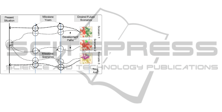
Figure 1: Backcasting principle.
The simulation is based on rules and creates
milestone scenarios as interim goals. Next to the
interim goals the simulation identifies trajectories.
They serve as development paths or guidelines and
express which steps have to be taken in order to get
from the present to the desired future state.
Backcasting is not a conditional method, as it is
forecasting, but it tells the modeller what needs to be
done and what needs to be achieved during the next
years in order to reach the (desired) future state.
The proposed backcasting model first creates a
future scenario. This part of the model utilizes an
Agent Based Model. The second part of the model
simulates backwards starting from the future state.
This part is implemented with a Python script and
linked to the Open Source GIS software Quantum
GIS.
The model is applied to a case study of
sustainable land-use planning in Salzburg, Austria.
The model shall support to reach a vision in land-use
planning in an appropriate time horizon. Thus the
results of the model run show in 10 years’ time steps
a successful back-casting of land-use classes from a
desired future state back until present time.
4 RESEARCH PROBLEM
Although the basic ideas of backcasting are
relatively old, general backcasting is until now
usually applied in non-spatial and non-explicit
context. Today, backcasting is often applied to back-
cast scenarios for whole cities or regions, for
instance, and often performed in workshops. The
unique characteristic of the presented backcasting
approach is its spatial explicity and automation: The
simulations in the proposed model are based on
polygonal equi-areal raster cells covering a selected
pilot region. So far no tangible method exists for the
application of the backcasting concept with spatial
reference and to my best knowledge also no model-
based, spatially explicit backcasting analysis has
been implemented yet.
An automated, GIS-based backcasting model will
reveal new perspectives and opportunities applicable
to research topics like spatial planning, safety,
construction, and health care. The basic research
results of this study will provide new possibilities
for the integration of decision support systems into
the workflow processes of spatial planning
specialists and decision makers.
The backcasting model will be applied in a pilot
region located in Salzburg, Austria. The model shall
help to counteract negative consequences of urban
development in this region by proposing a desired
future vision and related development paths how to
reach this future state.
This research forms a bridge between spatial
planning concepts and Geographic Information
Science and adds a new dimension to GIS. At the
same time it contributes to the provision of
innovative solutions.
5 STATE OF THE ART
The origin of the Backcasting concept goes back to
the 1970s, when it was introduced by Amory Lovins
as a planning method for electricity supply and
demand. At that time he referred to it as ‘backwards-
looking-analysis’. Since then, this method has been
regularly used in energy studies, often being referred
to as ‘energy analysis of the final consumption’
(Dreborg, 1996; Quist, 2000). According to Dreborg
(1996), general backcasting can be applied if:
Complex problems are dominating
Problems include a major trend
External factors greatly influence the problems
The time span for implementing changes is
SIMULTECH2014-DoctoralConsortium
4

long enough
Following the first implementation of
backcasting it took some time before it was realised
that the backcasting approach can be used in a much
wider range of applications. Sustainability became
an important field of application: In Sweden it has
been applied to various topics of sustainability
research, like transportation systems and air
transport. Further studies have been conducted on
the sustainability of water, mobility, or households
(Carlsson-Kanyama et al., 2008; Miola, 2008,
Banister et al. 2000 cited in Quist 2007). In Oxford,
backcasting has been applied e.g. within the VIBAT
project. There it was implemented to lower transport
carbon emissions (Hickman et al., 2009). A
Backcasting analysis aiming at an efficient energy
system with regard to the development of a
sustainable spatial organisation in Austria was
proposed by Wächter et al. (2012). Grêt-Regamey
and Brunner proposed a new approach in 2011,
namely to split the backcasting methodology into
inverse modelling (Grêt-Regamey & Brunner, 2011)
for explicit quantitative problems on the one hand
and a qualitative, strategic backcasting analysis for
complex problems in spatial planning on the other
hand. The latest research in this field dealt with the
implementation of a backcasting analysis with Agent
Based Models (ABMs). This was proposed by Van
Berkel and Verburg (2012) and was applied to
design policies for multifunctional landscapes to
simulate landscape changes.
6 METHODOLOGY
The proposed steps in my PhD towards a spatially
explicit and model-based backcasting approach
include (1) interviews with experts in the field of
spatial and urban planning. They have been selected
based on responsibilities for planning issues in the
pilot region. (2) Visions derived from the experts’
views. (3) Extensive analysis of the current state
including the land-use pattern and influencing
physio-geographical parameters, the population
distribution, and the future population development
in the pilot region. After having characterized the
pilot region (4) normative future scenarios are
created. In backcasting, future scenarios are often
visionary and decoupled from given structures or
circumstances, assuming that there are no constraints
for development. In the proposed approach the
developed future scenario represents a randomly
generated possible future pattern of land-use classes
in the pilot region. The development of the future
scenario is only influenced by exogenous parameters
which have been identified before to influence land-
use in the pilot region. The future scenario serves as
starting point for the next step (5), the backwards
modelling. This is performed by repeatedly applying
pre-defined rule-sets describing the backwards
development. The backwards modelling simulates
changes of equi-areal polygonal cells. Each of these
cells changes its state individually, resp. explicitly
from one time step to the next. These time steps are
represented by milestone scenarios that are created
as outputs during the whole backwards run,
representing interim goals. Further outputs of the
backwards modelling are development paths or
trajectories, revealing which changes have to take
place to reach the future scenario. Finally the
backwards modelling results in a modelled present
land-use pattern. This is compared with the actual
present land-use pattern in the pilot region which
should equal each other.
Based on a profound literature review two
principle modelling techniques have been identified
to be potentially suitable for the backcasting
approach. On the one hand these are Agent Based
Models (ABMs) which in general simulate actions
of autonomous agents, and display the behaviour
and dependencies between those agents and to other
agents. The aim of an ABM is usually not to reach
equilibrium, but to find out how a system will adapt
to changed conditions (Macal et al., 2010). On the
other hand these are Cellular Automata (CA). CA
are considered to be simple mathematical models
used for modelling discrete dynamic systems. These
models evolve due to a repeated application of
simple, deterministic rules (Wolfram, 1982). The
strength of those models is the simplicity of their
implemented transition rules which provide more
flexible system behaviour than other models. CA
can be applied to simulate the transition, for instance
from non-urban to urban landscape, of a system like
cells in a grid space depending on the
neighbourhood: Land-use changes at a certain cell
can thus depend on a previous land-use at this
location, on multi-criteria factors, or on the land use
of its neighbouring cells. These approaches allow a
numerical analysis of non-numerical geographic
systems. (Kim & Batty, 2011)
Based on an internal evaluation of strengths and
weaknesses of both approaches and discussions with
other experts, ABMs were chosen to be used for the
setup of the backcasting model. Nevertheless, the
ABM does not simulate individual agents moving
over a rasterized pilot area, but it simulates the
GIS-basedBackcasting-AMethodforParameterisationofSustainableSpatialPlanningandResourceManagement
5
changes of equi-areal polygon cells covering the
whole pilot area. It can be said that the ABM is
utilized as a CA.
The proposed model is applied to a selected pilot
region in Austria and is divided into two parts: The
first part creates future scenarios and is implemented
in ESRI’s Agent Analyst. This is an Agent Based
Modelling (ABM) extension for ArcGIS and builds
on Not Quite Python (NQPy) language. NQPy
satisfies nearly all requirements of GIS users, who
can also export the models and can add more
sophisticated functions.
Due to performance criteria the backwards
running process, consequently the second part,
which starts from a given future scenario, was
implemented as a Python script that is linked to the
open-source GIS software Quantum GIS (QGIS).
7 OUTCOME
The first results of the backcasting model present a
randomly generated future land-use scenario for
2050. This is input to a backwards running model
starting from 2050 and ending in 2006, as the final
stage. The ABM-based generated random future
scenario for 2050 is shown in Fig. 2.
Figure 2: Randomly generated future scenario of 2050.
This random future land-use pattern consists of the
four dominant land-use classes in the pilot region:
nature, settlement areas, agricultural land, and water
bodies. These data were extracted from Corine
Landcover data of 2006. The land-use class of nature
includes for instance forest areas, pastures,
grasslands, and other vegetated areas. Agricultural
areas include cultivated areas and arable land, and
settlement areas comprise urban areas, industrial
units, road and rail network, and other artificial
facilities (related to leisure, sports, etc.). All
simulated milestone scenarios, as well as the final
output, are made up of these four land-use classes.
To give an impression, two selected milestone
scenarios for the years 2040 and 2020 are presented
in Fig. 3a and b.
Figure 3a: Milestone scenario of 2040.
Figure 3b: Milestone scenario of 2020.
Finally, the output of the backwards running
model, which is similar to the land-use pattern of the
current time (here it is 2006), is presented in Fig. 4.
Figure 4: Final model output: the modelled land-use
pattern of 2006.
This modelled land-use pattern is similar to the
Corine Landcover data of 2006, which represents the
SIMULTECH2014-DoctoralConsortium
6

initial land-use pattern which was also input for the
model. This will always be the final output since the
backwards running model converges in any case
towards a fixed land-use pattern (in this case it is the
land-use pattern of 2006).
8 DISCUSSION
The aforementioned research questions that are also
addressed in my PhD and can be answered through
the presented outputs are:
1. Can backcasting exercises be reasonably
translated into models?
a. Which options could be used?
2. Are Geosimulation tools applicable to a
backwards working approach like backcasting?
c. Can Cellular Automata and/or Agent Based
Models be used?
With the gained results of the model, presented
in Fig. 2 to 4, it is possible to answer all research
questions: Yes, backcasting exercises can be
reasonably translated into models and yes,
Geosimulation tools are applicable to a backwards
working approach like backcasting. For the
generation of a random future scenario of 2050 an
Agent Based Model extension (Agent Analyst) for
ArcGIS is used. Cellular Automata (CA) models
might be used more often but it is made clear that
the ABM extension was not used in a sense of
studying independently acting agents. This
forecasting exercise resulted in a scenario
considering pre-defined rule-sets for the
development of future land-use patterns. The
backwards modelling is implemented as a Python
script linked to QGIS. This was preferred against the
Agent Analyst due to performance criteria and the
free availability of Python and QGIS. Both model
approaches, in Agent Analyst and Python/QGIS, act
like CA meaning that the equi-areal cells covering
the pilot area change their states according to
implemented rules. This statement also answers
question two, if Geosimulation tools are applicable
to a backwards working approach. Yes they are,
which has been proven by the herewith presented
approach of implementing backcasting with ABM
resp. a CA realized via Python.
9 OUTLOOK
Next developments will include the integration of a
baseline scenario for validation of the model. The
baseline scenario is created with Metronamica, land-
use simulation software, developed by RIKS at the
VU Amsterdam. “Metronamica is a unique generic
forecasting tool for planners to simulate and assess
the integrated effects of their planning measures on
urban and regional development. As an integrated
spatial decision support system, Metronamica
models socio-economic and physical planning
aspects. It incorporates a mature land use change
model that helps to make these aspects spatially
explicit” (Metronamica Website, 2014).
Furthermore a whole pool of future scenarios
will be created each having a different emphasis
representing for instance maximum compactness,
maximum Quality of Life or maximum autarky. The
rules for these scenarios are currently set-up.
An on-going update of the backcasting rule-set
includes the integration of neighbourhood influences
on settlement development and population
development in the pilot region. Preferred areas are
then not only influenced by physio-geographic
parameters but also by the surrounding environment.
Besides, the road network of the pilot region will
be included through an explicit raster input.
Since the two parts of the model, the creation of
a future scenario on the one hand, and the backwards
modelling on the other hand are for now
implemented in different software environments, it
is planned to implement both in the same
environment. Thus, the creation of future scenarios
is transferred to Python scripting as well.
Finally, a sensitivity analysis with respect to the
initial condition, which is obtained by the
backcasting model, is conducted in order to see
whether the same results can be achieved.
ACKNOWLEDGEMENTS
The research was funded by the Austrian Science
Fund (FWF) through the Doctoral College
GIScience (DK W 1237-N23).
REFERENCES
Carlsson-Kanyama, A., Dreborg, K.-H., Moll, H. C.,
Padovan, D., 2008. Participative backcasting: A tool
for involving stakeholders in local sustainability
planning. In: Futures 40, 34-46.
Clements, M. P., Franses, P. H., Swanson N. R., 2004.
Forecasting economic and financial time-series with
non-linear models. In: International Journal of
Forecasting, 20, 169-183.
GIS-basedBackcasting-AMethodforParameterisationofSustainableSpatialPlanningandResourceManagement
7

Clements, M. P., Hendry, D. F., 1998. Forecasting
economic time series. Cambridge University Press,
Cambridge, New York.
Dreborg, K.-H., 1996. Essence of Backcasting. In: Futures
28, 813-828.
Grêt-Regamey, A., Brunner, S., 2011. Methodischer
Rahmen für den Einsatz von Backcasting zur
Anpassung an den Klimawandel (Methodological
framework for the application of backcasting on
climate change issues). In: disP 184, 43-51.
Hickman, R., Ashiru, O., Saxena, S., Banister, D., 2009.
Visioning and Backcasting for Transport in London.
Stages 3/4, Background Report. Halcrow, London.
Web: www.vibat.org (May 26, 2014).
Kim, D., Batty, M., 2011. Calibrating Cellular Automata
Models for Simulating Urban Growth: Comparative
Analysis of SLEUTH and METRONAMICA. In: UCL
Working Papers Series No. 176.
Macal, C. M., North, M. J., 2010. Tutorial on agent based
modelling and simulation. In: Journal of Simulation 4,
151-162.
Metronamica, 2014. Metronamica Homepage. Web:
www.metronamica.nl (April 16, 2014).
Miola, A., 2008. Backcasting approach for sustainable
mobility. In: JRC Scientific and Technical Reports.
European Commission, Joint Reseqarch Centre -
Institute for Environment and Sustainability.-Ispra.
Murphy, A. H., Winkler, R. L., 1974. Probability
Forecasts: a Survey of National Weather Service
Forecaster. In: Bulletin of the American
Meteorological Society, 55, 1449–1452.
Quist, J., 2007. Backcasting, for a sustainable future: the
impact after 10 years. Eburon, Delft, 2007.
Van Berkel, D., Verburg, P., 2012. Combining exploratory
scenarios and participatory backcasting: using an
agent-based model in participatory policy design for a
multi-functional landscape. In: Landscape Ecology 27,
641-658.
Wächter, P., Ornetzeder, M., Rohracher, H., Scheurer, A.,
Knoflacher, M., 2012. Towards a Sustainable Spatial
Organization of the Energy System: Backcasting
Experiences from Austria. In: Sustainability 4, 193-
209.
Wolfram, S., 1982. Cellular Automata as Simple Self-
Organizing Systems. In: Caltech preprint CALT-68-
938.
SIMULTECH2014-DoctoralConsortium
8
