
Ocean Remote Sensing Data Predicts Trajectory of Oil Spill
An Analytical Model for SAR Polarimetric Scattering Matrix
Bo Wang
1
, Bertrand Chapron
2
and René Garello
3
1
Department of Computing and Communication, China University of Petroleum (Huadong), Qingdao, China
2
LOS, IFREMER, Plouzané, France
3
Department ITI, Telecom Bretagne, Brest, France
Keywords: Ocean Remote Sensing, Polarimetric SAR, Oil Trajectory.
Abstract: The ocean surface is part of the upper ocean which directly interacts with the overlying atmosphere and sea
ice. Once oil spill happened due to an accident such as the oil rig pipe leaking and exploring, it would be
unimaginable disaster to the oceanic environment, especially in the coastal area. If we can predict the
direction along which the oil films floats over the marginal sea surface, the damage would be controlled
within a pre-knowledge level. Under these knowledge, we analysed the polarimetric SAR (Synthetic
Aperture Radar) data with an analytical model to separate backscattered contributions by different sea
surface scatterers. Furthermore, it provides a possible prediction of the local wind direction by using the
separated backscattered signal. With this direction, it is ready to predict the direction of oil film’s floating.
1 INTRODUCTION
The ocean environment plays an important role in
the global climate change. Ocean remote sensing
offers satellite observations as a data collection
which could be assimilated into ocean models. Such
assimilations as SAR acquisition used in a flood
model (García-Pintado et al., 2013), the ozone
analyses based on Envisat data (Geer et al., 2006;
Lahoz et al., 2007), the cloud and precipitation
observations effort in a numerical weather prediction
model (Ohring et al., 2005), have all achived
benefits from the satellite data. The ocean surface is
part of the upper ocean which directly interacts with
the overlying atmosphere and sea ice. Surface films
isolate the air from the ocean surface, they also
damp the surface wave vibration (Gade et al., 2006),
leaving a dark area or dark textures in the SAR
imagery. Based on the above understandings, we
analysed multi-polarization data by SAR onboard of
the Radarsat-2 satellite, with the first result of wind
wave direction estimated by a Bragg wave
component. This estimation of local wind direction
can help to predict the trajectory of the surrounding
oil films, by applying this parameter into an ocean
wave prediction model, such as the numerical model
Wavewatch III (Feng et al., 2006).
2 SAR POLARIMETRY
SAR measurements or derivatives have recently
been assimilated into models, including hydraulic
(Giustarini et al., 2011), snowpack (Phan et al.,
2013). The efforts to ocean wave modelling trace
back to the 1990s when a large number of researches
focused on the wave retrieval from the SAR imagery
(De las Heras et al., 1995; Olsen et al., 1995;
Hasselmann et al., 1997; Breivik et al., 1998 ),
which have seldom updates recently. Polarimetric
SAR refocused the researches on ocean wave
retrieval, however, it had rarely been considered that
the sea surface is composed by different scattering
mechanisms. A theoretical model concern different
polarization properties in the radar backscattering
coefficient expressed the NRCS (Normalized Radar
Cross-Section) as the sum of polarization dependent
Bragg and polarization independent Scalar
contributions (Quilfen et al., 1999). Following this
theoretical model, we proposed an analytical model
for polarimetric SAR scattering matrix. In our
model, the Bragg contribution was expressed in
scattering matrix by the tilt Bragg model, while the
Scalar contribution concerned the Rayleigh
scattering from foams introduced by sea surface
wave breaking, the specular reflection by the steep
wave, and double-bounced metallic sea surface
822
wang B., Chapron B. and Garello R..
Ocean Remote Sensing Data Predicts Trajectory of Oil Spill - An Analytical Model for SAR Polarimetric Scattering Matrix.
DOI: 10.5220/0005125308220827
In Proceedings of the 4th International Conference on Simulation and Modeling Methodologies, Technologies and Applications (MSCCEC-2014), pages
822-827
ISBN: 978-989-758-038-3
Copyright
c
2014 SCITEPRESS (Science and Technology Publications, Lda.)

target. The interaction between i.i.d. (independent
and identically distributed) scatterers has been
considered within each pixel area using the random
walk model, with the assumption that the Bragg
contribution is the vector sum of the random walk by
all the Bragg scatterings. This analytical model was
iteratively resolved by a former estimate (WANG et
al., 2011). In this iteration algorithm, a Bragg related
polarization ratio, β, was determined iteratively to
separate the Bragg contribution from the non-Bragg
contribution. This model is indeed the theoretical
model of Quilfen et al. when the cross product of
Bragg and Scalar contributions is zero. But in real
case, the latter could not be ignored. Thus the sea
surface depolarization and polarization can be
separated better by complex scattering matrix than
by NRCS. Wind seas were also retained from
separated scattering contributions, indicating a finer
resolution than traditional retrieval method.
3 WIND DIRECTION
3.1 Polarization Wind Wave
Parameters
Since 1990s, global measurements of the two-
dimensional wave spectrum by space-borne SAR
sensors on-board of satellites such as ERS-1/2,
Radarsat-1/2 has been investigated. Missions of
ocean wave investigated mapping of ocean wave
spectrum from the SAR image spectrum
(Hasselmann and Hasselmann, 1991), the unification
of the directional spectrum (Elfouhaily et al., 1997),
and the effect of the longer wave and swell (Chen et
al., 2000; Plant, 2003; Ardhuin et al., 2007).
Furthermore, the bound wave / free wave model
(Plant et al., 2010) consists with sea surface slope
spectrum measured in 1950s (Cox, 1958). However,
all the algorithms were limited within the range of
wavelength longer than a cut-off wavelength, till the
full polarization radar imagery being available. At a
specially selected orientation angle, the modulation
of the wave slope on radar measured intensity could
be enhanced, better than any of that from the
standard linear polarization HH, VV, HV or VH
(Boerner et al., 1992; Schuler et al., 1995). It is
possible to find this special orientation angle to
solve optimal polarization problems. This principle
is called polarization modulation transfer function
(MTF) (Schuler et al., 1995). A combined
polarization MTF with an eigenvector α angle
modulation (Cloude and Pottier, 1996) could also
enhance the wave slope in the azimuth direction
(Schuler et al., 2004). However, Schuler's method
was questioned for applying to the sea surface by not
considering the non-linear velocity bunching effect
(Alpers, 1983).
The α parameter of the entropy-anisotropy-α
decomposition theorem (Cloude and Pottier, 1996) is
roll-invariant in the azimuth direction. It has high
sensitivity to wave-induced change of local
incidence angle. Decomposition theorems consider
polarimetric radar backscattered signal matrices as
the summation of different scattering mechanisms
coherently or incoherently. According to Cloude-
Pottier's theorem, the mean scattering matrix has an
eigenvector
k
√
e
e
e
(1)
in which λ, α is the mean target power (span) and
roll-invariant mean scattering respectively, the rest
three parameters β, δ, γ are orientation angle related,
and rotation variant, could be used to define the
target polarization orientation angle. The five
parameters are connected with the radar
measurements by
∙
∗
∙
∗
(2)
in which
is the covariance matrix, and
(3)
is the '3-D Pauli feature vector' (Lee and Pottier,
2009), where S
,P,Q∈H,V is the components
of Sinclair scattering matrix.
From Eq. (1) and Eq. (3), the approximation of
the α parameter from polarimetric SAR
measurements should be as
tanα
(4)
On the other hand, the relationship between α
angle and incidence angle θ
could be find as Eq.
(5),
tanα
(5)
using the SMP model and considering only
incidence angle, for the water dielectric constant
ϵ→∞.
OceanRemoteSensingDataPredictsTrajectoryofOilSpill-AnAnalyticalModelforSARPolarimetricScatteringMatrix
823
So far, the range slope can be derived from the
local incidence angle corresponding to α angle
subtracted by the incidence angle according to the
radar geometry as
γ
(6)
3.2 Wind Wave Direction Retrieval
Based on the above analysis, the local incidence
angle is reasonable to be iteratively estimated by the
polarimetric SAR measurements, hence possible to
assign each scattering contribution due to different
polarization characteristics (Wang, 2013). The
Bragg scattering of wind seas is considered to be
sensitive to the radar polarization, and the other
scattering mechanisms introduced by steep waves or
breakers are insensitive to the polarization, being
scalar contributions. Separated scattering
contributions correspond to different range of the
ocean wave spectra. As the primary results, we
showed the capability of wind wave direction
retrieval from the Bragg scattering component.
3.3 First Results
In-situ platforms collocated with Radarsat-2 satellite
data set are offered by the Observing System
Monitoring Center (OSMC) programme funded by
NOAA/OCO, providing both the near real and
historical status of meteorological and
oceanographic data collection systems. These
platforms include both buoys and voluntary ships,
returning one record per hour, generally. Records in
the nearest distance were interpolated in time for
satellite acquisitions in August and September.
Other records following up are supplied by
meteorological moored buoys located exactly inside
of the satellite image scene. The result does not
always support our assumption that a special part of
the wave spectra could be assigned for the Bragg
scattering and scalar contribution separately. To the
contrary, scalar contribution retains a wind wave
direction much more consist with the in-situ data
than the Bragg contribution. We are not ready to
give an explanation in this paper, however, the
reginal currents should be considered more carefully
since all the contradiction data located in the
Mediterranean Sea, where the swell is not so
significant to domain in the scalar component as the
polarization insensitive contribution, both in summer
and in winter. Nevertheless, the results from the data
located in the North Sea and North West Atlantic
Ocean indicates consisted wind derived short wave
direction on the Bragg scattering contributions.
3.3.1 Case Study
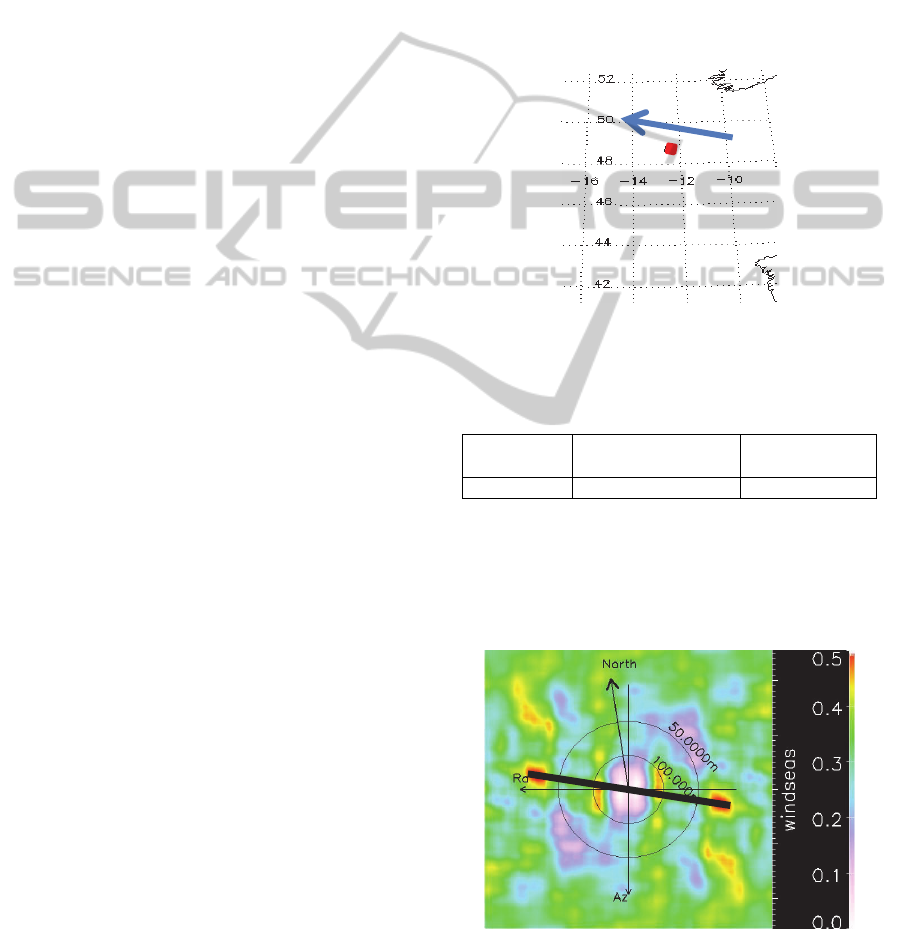
We showed in Fig. 1 the location of the SAR
imagery acquired on 2011 December 5
th
, to the south
west of Scotland and northwest of Bretagne, with the
satellite LOS of 45.11 deg. in the center of image.
The local wind speed is 10.29m/s, blowing to the
direction of 290 deg. departing from the North, as
shown in Table 1.
Figure 1: The location of the SAR imagery 20111205 (red
square) and the local wind direction (blue arrow).
Table 1: The in-situ measurements to be counterpart with
the SAR imagery of 20111205.
Wind speed
(m/s)
Wind direction
(degree)
Wave height
(m)
10.29 290 4.5
3.3.2 The Direction
The cross spectrum of Bragg component in VV
polarization indicated a peak direction consist with
the in-situ 290 deg. from the North, shown in Fig. 2.
Figure 2: Cross spectrum of Bragg component in VV
polarization. The peak direction (thick line in black)
retains the local wind direction of 290 deg. from the
North.
SIMULTECH2014-4thInternationalConferenceonSimulationandModelingMethodologies,Technologiesand
Applications
824
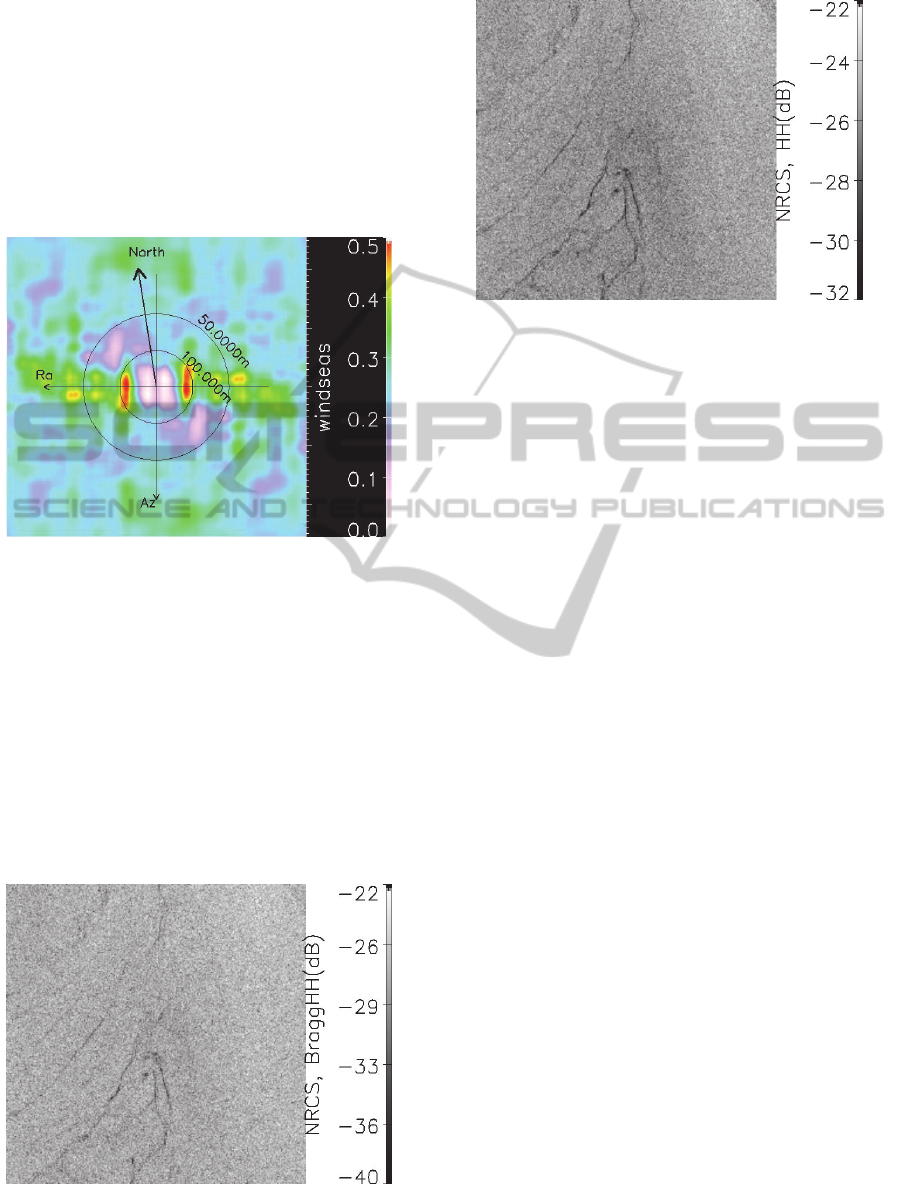
It is clear from the comparison of Figure 2 to 3
that the separation of scattering mechanisms such as
Bragg contribution helped to tell the local wind
direction, which was impossible by using the single
polarization data. The direct SAR measurement is
definitely a combination of different scattering
contributions. This study supported the theoretical
model of NRCS concerning the polarization
(Quilfen et al., 1999).
Figure 3: Cross spectrum of SAR imagery in VV
polarization. There is hard to find the local wind direction.
4 OIL FILMS
Surface films could not only be a natural sea slick
generated by plankton, but also the floating oil
introduced by an oil spill. Oil spill is easily to
accompany with an accident such as the oil rig pipe
leaking and exploring. Oil spill ruins the local sea,
depresses the air/sea interaction, and is even worse
to the environment than the natural plankton films.
Figure 4: Bragg scattering component in HH polarization.
Figure 5: Direct SAR measurement in HH polarization.
In Fig. 4 and 5 is the Bragg scattering component
and the direct SAR measurement, both in HH polarization.
The improvement from original measurement to the
separated single scattering mechanism could be indicated
by the expansion of the range of data value from [-32dB,
22dB] to [-40dB, -22dB], although the image quality has
not been much improved. On the other hand, the slick
texture domains the minimum values, i.e. around -40dB
for Bragg component. It helped the accuracy of local wind
direction estimated from the cross spectrum of Bragg
contributions.
5 CONCLUSIONS
The polarimetric SAR data have been analysed in
this paper, introducing an estimation of short wave
directions, for the wind seas with a wavelength less
than 50 meters. This kind of short wave is
considered to be the wind wave, the propagation
direction of which accords to the local wind. The
local wind direction is critical to predict the
trajectory of oil spills. However, the oil films float
over the sea surface not only along the local wind,
but also tracing the longer wave and current. This is
the same problem that encountered by the
contradiction data of Mediterranean Sea in section 3.
For example, the predictions for significant wave
height by the numerical model such as NCEP
Wavewatch III have been identified to have
substantial differences when include and exclude
ocean surface currents.
ACKNOWLEDGEMENTS
This work was partially supported by a grant from
the European Union, the Brittany Region and the
OceanRemoteSensingDataPredictsTrajectoryofOilSpill-AnAnalyticalModelforSARPolarimetricScatteringMatrix
825

Brest Metropole Oceane to the VIGISAT project, in
the framework of a FEDER grant Presage # 32635,
and by “the Fundamental Research Funds for the
Central Universities” No. 14CX02135A. The
Radarsat-2 data was supported by CLS under the
contracts #08 GET 13M and 09 GET 11M.
REFERENCES
García-Pintado, J., Neal, J. C., Mason, D. C., Dance, S. L.,
Bates, P. D., Scheduling satellite-based SAR
acquisition for sequential assimilation of water level
observations into flood modelling, Journal of
Hydrology 495 (2013) 252-266.
Geer, A. J., Lahoz, W. A., Bekki, S., Bormann, N., Errera,
Q., Eskes, H. J., Fonteyn, D., Jackson, D. R., Juckes,
M. N., Massart, S., Peuch, V. H., Rharmili, S., Segers,
A., The ASSET intercomparison of ozone analyses:
method and first results, Atmos. Chem. Phys., 6, 5445-
5474, 2006.
Lahoz, W., Geer, A., Bekki, S., Bormann, N., Errera, Q.,
Eskes, H. J., Fonteyn, D., Jackson, D. R., Juckes, M.
N., Massart, S., Peuch, V. H., Rharmili, S., Segers, A.,
Evaluation of MIPAS and SCIAMACHY data using
data assimilation, In Proceedings of the Third
Workshop on the Atmospheric Chemistry Validation of
Envisat (ACVE-3), 4-7 December 2006, ESA SP-642,
February 2007.
Ohring, G., Weng, F., Errico, R., Mahfouf, J. Turk, J.,
Bauer, P., Campana, K, Ferrier, B., Assimilation of
satellite cloud and precipitation observations in NWP
models: Report of a workshop, In Proceedings of
ITSC-14, Beijing, May 25-31, 2005.
Gade, M., Hühnerfuss, H., Korenowski, G., 2006, Marine
Surface Films, Springer-Verlag Berline Heidelberg,
The Netherlands.
Feng, H., Vandemark, D., Quilfen, Y., Chapron, B.,
Beckley, B., “Assessment of wind-forcing impact on a
global wind-wave model using the TOPEX altimeter”,
Ocean Engineering, Vol. 33, Issues 11-12, August
2006, P. 1431-1461
Giustarini, L., Matgen, P., Hostache, R., Montanari, M.,
Plaza, D., Pauwels, V. R. N., De Lannoy, G. J. M., De
Keyser, R., Pfister, L., Hoffmann, L., Savenije, H. H.
G., Assimilating SAR-derived water level data into a
hydraulic model: a case study, Hydrol. Earth Syst. Sci.
Discuss., 8, 2103-2144, 2011)
Phan, X. V., Ferro-Famil, L., Gay, M., Durand, Y.,
Dumont, M., Morin, S., Allain, S., D’Urso, G., Girard,
A., 3D-VAR multilayer assimilation of X-band SAR
data into a detailed snowpack model, The Cryosphere
Discuss., 7, 4881-4912, 2013
De las Heras, M. M., Burgers, G., Janssen, P. A. E. M.,
Wave data assimilation in the WAM wave model,
Journal of Marine Systems 6 (1995) 77-85
Olsen, R. B., Dunlap, E. M., De Margerie, S., Wilson, L.
J., Assimilation of SAR image spectra in a spectral
ocean wave model, In Proceeding of Geoscience and
Remote Sensing Symposium, 1995
Hasselmann, S., Lionello, P., Hasselmann, K., An optimal
interpolation scheme for the assimilation of spectral
wave data, Journal of Geophysical Research, Vol. 102,
No. C7, Pages 15823-15836, 1997
Breivik, L. A., Reistad, M., Schyberg, H., Sunde, J.,
Krogstad, H. E., Johnsen, H., Assimilation of ERS
SAR wave spectra in an operational wave model,
Journal of Geophysical Research, Vol. 103, No. C4,
Pages 7887-7900, 1998
Quilfen, Y., Chapron, B., Bentamy, A., Gourrion, J.,
Elfouhaily, T., Vandemark, D., Global ERS 1 and 2
and NSCAT observations: Upwind / crosswind and
upwind / downwind measurements, J. Geophys. Res.,
vol. 104, C5, no. 11,459-11,469, May 15, 1999.
Wang, B., Chapron, B., Mouche, A., Mercier, G., Garello,
R., He, M., Depolarization model - a polarimetry
approach, presented at the CFOSAT meeting, 2011.
Hasselmann, K., Hasselmann, S., On the nonlinear
mapping of an ocean wave spectrum into a synthetic
aperture radar image spectrum and its inversion, J.
Geophysical Research, vol. VOL. 96, No. C6, no.
P.10713-10729, June 15, 1991.
Elfouhaily, T., Chapron, B., Katsaros, K., Vandemark, D.,
A unified directional spectrum for long and short
wind-driven waves, J. Geophys. Res., vol. Vol. 1O2
(C7), no. P.15781-15796, July 15, 1997.
Chen, G., Belcher, S. E., Effects of long waves on wind-
generated waves, Journal of Physical Oceanography,
Vol.30, September 2000.
Plant, W. J., Bound waves and sea-surface slope, In
Proceedings of OCEANS2003.San Diego, CA, USA,
vol. Vol.4, no. 1825-1828, 22-26 Sept. 2003.
Ardhuin, F., Herbers, T. H. C., Vledder, G. P., Watts, K.
P., Jensen, R., Graber, H. C., Swell and slanting-fetch
effects on wind wave growth, Journal of Physical
Oceanography, Vol.37, no. pp.908-931, April 2007.
Plant, W., Keller, W. C., Hayes, K., Chatham, G.,
Normalized radar cross section of the sea for
backscatter: 1. mean levels, J. Geophys. Res., vol. 115,
C09032, 2010.
Cox, C. Measurements of slopes of high frequency waves,
J. Mar. Res., vol. 16, no. 199-225, 1958.
Boerner, W. M., Liu, C. L., Zhang, X., Comparison of
optimization procedures for 2x2 sinclair, 2x2 graves,
3x3 covariance and 4x4 mueller (symmetric) matrices
in coherent radar polarimetry and its application to
target versus background discrimination in microwave
remote sensing and imaging, International Journal of
Advances in Remote Sensing (IJARS), Vol. 2, No.1-1,
no. pp. 55-82, January 1993.
Schuler, D. L., Lee, J. S., A microwave technique to
improve the measurement of directional ocean wave
spectra, Int. J. Remote Sensing, Vol. 16, No. 2, no.
199-215, 1995.
Cloude, S. R., Pottier, E., A review of target
decomposition theorems in radar polarimetry, IEEE
Transacctions on Geoscience and Remote Sensing,
VOL.34, NO. 2, MARCH 1996.
SIMULTECH2014-4thInternationalConferenceonSimulationandModelingMethodologies,Technologiesand
Applications
826

Schuler, D. L., Lee, J. S., Kasilingam, D., Pottier, E.,
Measurement of ocean surface slopes and wave
spectra using polarimetric sar image data, Remote
Sensing of Environment, vol. 91, no. 198 - 211, 2004.
Alpers, W., Monte carlo simulations for studying the
relationship between ocean wave and synthetic
aperture radar image spectra, J. Geophys. Res., vol.
Vol. 88, NO. C3, no. p.1745-1759, February 28, 1983.
Wang, B., Synthetic aperture radar multi-polarization
ocean surface characteristics and ship detection,
Ph.D. dissertation, Télécom Bretagne, Brest,
December 2013.
OceanRemoteSensingDataPredictsTrajectoryofOilSpill-AnAnalyticalModelforSARPolarimetricScatteringMatrix
827
