
Querying Open Street Map with XQuery
Jes
´
us M. Almendros-Jim
´
enez and Antonio Becerra-Ter
´
on
Information Systems Group, University of Almer
´
ıa, 04120 Almer
´
ıa, Spain
{jalmen, abecerra}@ual.es
Keywords:
Open Street Map, Urban Maps, Spatial Databases, XQuery, XML.
Abstract:
In this paper we present a library for querying Open Street Map (OSM) with XQuery. This library is based
on the well-known spatial operators defined by Clementini and Egenhofer, providing a repertoire of XQuery
functions which encapsulate the search on the XML document representing a layer of OSM, and make the
definition of queries on top of OSM layers easy. In essence, the library provides a repertoire of OSM Operators
for points and lines which, in combination with Higher Order facilities of XQuery, facilitates the composition
of queries and the definition of keyword based search geo-localized queries. OSM data are indexed by an
R-tree structure, in which points and lines are enclosed by Minimum Bounding Rectangles (MBRs), in order
to get shorter answer time.
1 INTRODUCTION
Open Street Map (OSM) (Haklay and Weber, 2008) is
a collaborative project to create a free editable map of
the world. It is supported by the non-profit organiza-
tion called OSM Foundation. OSM data can be visu-
alized from the OSM web site
1
, but also many appli-
cations have been built for the handling of maps (see
http://wiki.openstreetmap.org/wiki/Software for a list
of tools). OSM can be represented with many for-
mats; in fact, there are many tools available in order
to export OSM to XML, KML, SVG, etc.
With the increasing interest in OSM, many tools
have been devoloped. However, their main taks are
edition, export, rendering, conversion, analysis, rout-
ing and navigation, and little attention focuses on
querying. Querying urban maps can be seen from
many points of view. One of the most popular query-
ing mechanism is the so-called routing or navigation;
for instance, the most suitable route to go from one
point to another of the city. In this case, the input of
the query are two points (or streets) and the output is
the sequence of instructions needed to reach the des-
tination.
Nevertheless, querying an urban map can also be
interesting for city sightseeing. In this case, places
of interests around a given geo-localized point are the
major goal. The input of the query are a point and
a city area, close to the given point, and the output
is a set of points. The tourist would also like to query
1
http://www.openstreetmap.org
streets close to a given street when looking for a hotel,
querying parking areas, restaurants, high ways to go
out, etc. In such queries, the input is a given point (or
street) and the output could be a number of streets,
parking areas, restaurants, high ways, etc.
Most tools are able to query OSM with very sim-
ple commands: searching by tag and relation names.
This is the case of JOSM
2
and Xapiviewer
3
. The OSM
Extended API or XAPI
4
is an extended API that of-
fers search queries in OSM with a XPath flavoring.
The Overpass API (or OSM3S)
5
is an extension to se-
lect certain parts of the OSM layer. Both XAPI and
OSM3S act as a database over the web: the client
sends a query to the API and gets back the dataset
that corresponds to the query. OSM3S has a proper
query language which can be encoded by an XML
template. OSM3S offers more sophisticated queries
than XAPI, but it is equipped with a rather limited
query language.
XQuery (Robie et al., 2014; Bamford et al., 2009)
is a programming language proposed by the W3C
as standard for handling XML documents. It is a
functional language in which for-let-orderby-where-
return (FLOWR) expressions are able to traverse
XML documents. It can express Boolean conditions,
and provides a format to output documents. XQuery
has a sublanguage, called XPath (Berglund et al.,
2
https://josm.openstreetmap.de/
3
http://osm.dumoulin63.net/xapiviewer/
4
http://wiki.openstreetmap.org/wiki/Xapi
5
http://overpass-api.de/
61
Almendros-Jiménez J. and Becerra-Terón A..
Querying Open Street Map with XQuery.
DOI: 10.5220/0005365500610071
In Proceedings of the 1st International Conference on Geographical Information Systems Theory, Applications and Management (GISTAM-2015), pages
61-71
ISBN: 978-989-758-099-4
Copyright
c
2015 SCITEPRESS (Science and Technology Publications, Lda.)

2010), whose role is to address nodes on the XML
tree. XPath is properly a query language equipped
with Boolean conditions and many path-based opera-
tors. XQuery adds expressivity to XPath by providing
mechanisms to join several XML documents.
In this paper, we present a library for query-
ing OSM with XQuery. This library is based on
the well-known spatial operators defined by Clemen-
tini (Clementini and Di Felice, 2000) and Egenhofer
(Egenhofer, 1994), providing a repertoire of XQuery
functions which encapsulate the search on the XML
document representing a layer of OSM, and making
the definition of queries on top of OSM layers easy.
Basically, the library provides a repertoire of OSM
Operators, for points and lines which, in combina-
tion with Higher Order facilities of XQuery, makes
the Composition of Queries and the definition of Key-
word based search Geo-Localized queries easy. OSM
data are indexed by an R-tree structure (Hadjielefthe-
riou et al., 2008), where lines and points are enclosed
by Minimum Bounding Rectangles (MBRs) in order to
get shorter answer time.
Our work focuses on the retrieval of information
and querying from urban maps. Although navigation
is a interesting type of query, we are more interested
in querying the elements of a urban map in a cer-
tain area or layer and taking as input a given point
or street. Queries about buildings, parkings, lakes,
etc. is considered as future work. The advantages of
our approach are that our XQuery library makes the
definition of queries on top of OSM layers easier. A
repertoire of OSM spatial operators are implemented
in terms of the spatial operators of Clementini and
Egenhofer. Such repertoire of operators is specific for
OSM maps, that is, it handles the particular nature of
the XML representation of OSM. It includes, for in-
stance, the operator isEndingTo for streets (i.e. ways),
which returns true whenever a street ends (without
crossing) to another one. Another operator, isCon-
tinuationOf also for streets, returns true whenever a
street is the continuation of another one. Both are par-
ticular cases of Clementini’s operator touches. In ad-
dition, our proposal includes a batch of emphCoordi-
nate based XQuery functions, allowing the expression
of interesting Geo-positioning queries. Higher order
functions in XQuery
6
allow definitions of composi-
tion of queries and keyword based search queries in a
easy way. Queries are expressed in terms of filtering,
composition, set-based operators (union, intersection
and difference) as well as mapping.
For instance, a typical query in our approach
is something like: “Retrieve the schools close to
6
http://www.w3.org/TR/xpath-functions-30/#higher-
order-functions
a street, wherein “Calzada de Castro” street ends”
which combines proximity to a street, keywords (i.e.,
school), as well as the operator (i.e., isEndingTo). It
can be expressed as follows:
let $waysAllEndingTo :=
fn:filter(
rt:getLayerByName(.,"Calle Calzada de Castro"),
osm:isEndingTo(osm:getOneWay(., "Calle Calzada de Castro"),?))
return
fn:filter(
fn:for-each($waysAllEndingTo, rt:getLayerByOneWay(.,?)),
osm:searchTags(?,"school"))
which uses higher-order functions (i.e., filter and for-
each) of XQuery.
A good performance of query processing is en-
sured due to the use of indexing for OSM data. An
R-tree structure implemented as an XML document
is used to index OSM nodes and ways enclosed by
MBRs. Using the R-tree structure, we are able to re-
trieve the elements (i.e., points and streets) close to a
given point or street, and thus, to process in reason-
able time, queries focused on the vicinity of a point
or street even for large city maps. Thus, for Geo-
localized Queries, we can get better answer times.
We have implemented our library with the BaseX
XQuery processor (Grun, 2015). The implementation
is based on the transformation of geometric shapes of
OSM into the corresponding GML data. Then GML
data are handled by the Java Topology Suite (JTS)
(Shekhar and Xiong, 2008), an open source API that
provides a spatial object model and a set of spatial
operators. JTS is available for most of XQuery pro-
cessors due to the XQuery Java Binding mechanism.
This is the case of Exist (Meier, 2003) and Saxon
(Kay, 2008) processors as well as BaseX. Thus, the
library is portable to other XQuery implementations.
We have also tested our approach by using the JOSM
tool (Haklay and Weber, 2008), that works with the
XML representation of OSM data, customized with
an style to highlight points and streets obtained from
the queries. We have evaluated our library with
datasets of several sizes, for which benchmarks show
that shorter answer times are obtained even for large
city maps. Finally, the developed library is available
from http://indalog.ual.es/osm. The examples shown
in this paper can also be downloaded here.
The rest of this article is organized as follows.
Section 2 will present the basic elements of Open
Street Map. Section 3 will define the XQuery li-
brary. Section 4 will show examples of queries and
give benchmarks for several datasets. Section 5 will
compare with related work and finally, Section 6 will
conclude and present future work.
GISTAM2015-1stInternationalConferenceonGeographicalInformationSystemsTheory,ApplicationsandManagement
62

2 OPEN STREET MAP
OpenStreetMap uses a topological data structure
which includes the following core elements: (1)
Nodes which are points with a geographic position,
stored as coordinates (pairs of a latitude and a longi-
tude) according to WGS84. They are used in ways,
but also to describe map features without a size like
points of interest or mountain peaks. (2) Ways are or-
dered lists of nodes, representing a poly-line, or pos-
sibly a polygon if they form a closed loop. They are
used in streets and rivers as well as areas: forests,
parks, parkings and lakes. (3) Relations are ordered
lists nodes, ways and relations. Relations are used for
representing the relationship of existing node points
and ways. (4) Tags are key-value pairs (both arbitrary
strings). They are used to store metadata about the
map objects (such as their type, their name and their
physical properties). Tags are attached to a node, a
way, a relation, or to a member of a relation.
As an example of OSM, Figure 1 shows the visu-
alization with JOSM of a piece of the Almer
´
ıa (Spain)
city map. In order to represent such a map, OSM uses
XML labels: node, relation and way, and each label
can have several attributes; for instance, node has lat
and lon, among others, for representing latitude and
longitude of the node. A node, representing a point
of interest of the city, can have tags for adding infor-
mation about the point, using attribute pairs key (k)
and value (v) with this end. For instance, the museum
“Museo Arqueologico” of Almer
´
ıa city is represented
as follows:
<node lat=’36.8386557’ lon=’-2.4556049’>
<tag k=’name’ v=’Museo Arqueologico’ />
<tag k=’tourism’ v=’museum’ />
</node>
The main element of the OSM is the way that
serves not only to represent streets but also buildings,
parkings, etc. Ways are described by a sequence of
node references, called nd, which link ways to nodes,
and tags as follows:
<way>
<nd ref=’-3625’ />
<nd ref=’-3623’ />
<nd ref=’-3621’ />
<tag k=’highway’ v=’residential’ />
<tag k=’name’ v=’Calle Calzada de Castro’ />
</way>
When the way is related to a building, park, etc,
specific tags are used inside the way description, for
instance:
<way id=’27161540’>
<nd ref=’298004115’ />
<nd ref=’298004116’ />
Figure 1: (Spain) Almer
´
ıa City Map.
<nd ref=’298004119’ />
<nd ref=’298004128’ />
<nd ref=’298004115’ />
<tag k=’amenity’ v=’parking’ />
</way>
In spite of the simplicity of the XML represen-
tation of OSM, many features in a OSM layer (see
http://wiki.openstreetmap.org/wiki/Map Features for
a list) can be described. Finally, relations are used to
relate elements of the map, for instance, bus routes:
<relation id=’147091’>
<member type=’way’ ref=’27197940’ role=’3,11,12’ />
<member type=’way’ ref=’27197939’ role=’3,7,11,12’ />
<member type=’way’ ref=’35031199’ role=’3,11,12’ />
<member type=’way’ ref=’27197944’ role=’7’ />
<member type=’way’ ref=’27197945’ role=’7’ />
<member type=’way’ ref=’25586878’ role=’3,11,12’ />
<member type=’way’ ref=’30953417’ role=’3,11,12’ />
<member type=’way’ ref=’25585669’ role=’3,5,6,11,12’ />
<member type=’way’ ref=’27161590’ role=’5,6,12’ />
<member type=’way’ ref=’27210271’ role=’3’ />
<member type=’way’ ref=’31484654’ role=’12’ />
<member type=’way’ ref=’27210293’ role=’3,5,6,12’ />
<member type=’way’ ref=’50004718’ role=’12’ />
<tag k=’route’ v=’bus’ />
<tag k=’type’ v=’route’ />
</relation>
3 XQuery LIBRARY FOR OSM
Our main goal is to provide a repertoire of OSM Op-
erators, implemented as a XQuery library which, in
combination with Higher Order facilities of XQuery,
enables the expression of spatial queries over OSM
maps easily. Moreover, we have to ensure shorter an-
QueryingOpenStreetMapwithXQuery
63

swer time for large maps. An R-tree structure to in-
dex OSM maps has been implemented, and suitable
XQuery functions to retrieve the layer of objects close
to a given node and way have been developed.
Next, we will show the elements of the XQuery
library which includes:
(1) OSM Indexing to generate an R-tree and retrieve
elements from it,
(2) Transformation Operators to transform OSM ge-
ometries into GML ones,
(3) OSM Spatial Operators to check spatial relations
over OSM geometries, that is, ways and nodes
representing streets and points, respectively,
(4) Higher Order functions to facilitate the composi-
tion of queries and keyword based search queries.
3.1 OSM Indexing
In order to handle large city maps, in which the layer
can include many objects, an R-tree structure to in-
dex objects is used. The R-tree structure is based, as
usual, on MBRs to hierarchically organize the content
of an OSM map. Moreover, they are also used to en-
close the nodes and ways of OSM in leaves of such
structure. Figure 2 shows a visual representation of
the R-tree of a OSM layer for Almer
´
ıa (Spain) city
map. These ways have been highlighted in different
colors (red and green) and MBRs are represented by
light green rectangles.
The R-tree structure has been implemented as an
XML document. That is, the tag based structure of
XML is used for representing the R-tree with two
main tags called node and leaf. A node tag represents
the MBR enclosing the children nodes, while leaf tag
contains the MBR of OSM ways and nodes. The tag
mbr is used to represent MBRs. For instance, the R-
tree of the OSM map of Figure 1 is represented in
XML as follows:
<node x="-2.4574724" y="36.8305714"
z="-2.4473768" t="36.849285">
<node x="-2.4565026" y="36.8319462"
z="-2.4476476" t="36.849285">
<node x="-2.4557511" y="36.8319462"
z="-2.4491401" t="36.8414807">
<leaf x="-2.4557511" y="36.8347249"
z="-2.4522051" t="36.8396123">
<mbr x="-2.4533564" y="36.8383646"
z="-2.452359" t="36.8384662">
<way ...>
....
</way>
</mbr>
....
The root element of the XML document is the root
node of the R-tree, and the children can be also nodes
Figure 2: R-tree based indexing of OSM Maps.
and, in particular, leaves. x, y, z and t attributes of
nodes are the left (x, y) and right corners (z, t) of the
MBRs. MBRs are also represented by left and right
corners.
We have implemented in XQuery a set of func-
tions to handle R-trees for OSM. The function
load file generates a R-tree from an OSM layer.
The function getLayerbyName obtains, given the
name of a node or way, the nodes or ways of the OSM
layer whose MBR overlaps the MBRs of the given
node or way. In case of points, overlapping means in-
clusion. In other words, getLayerbyName obtains the
elements that are close to the given node or way. Fi-
nally, each node and way in isolation can be retrieved
by means of getOneWay and getNode, respectively.
Our proposed query language uses
getLayerbyName as basis, in the sense that,
queries have to be related to a certain area of interest,
given by the name of a point (park, pharmacy, etc.,)
or by the name of a street. In other words, our
query language is useful for Geo-localized queries.
Once the layer of the area of interest is retrieved,
GISTAM2015-1stInternationalConferenceonGeographicalInformationSystemsTheory,ApplicationsandManagement
64

Name Definition
Equals(a,b) Their interiors intersect and no part of the interior or boundary of one geometry
intersects the exterior of the other
Disjoint(a,b) They have no point in common
Touches(a,b) They have at least one boundary point in common, but no interior points
Contains(a,b) No points of b lie in the exterior of a, and at least one point of the interior of b
lies in the interior of a
Covers(a,b) Every point of b is a point of (the interior of) a
Crosses(a,b) They have some but not all interior points in common (and the dimension of the
intersection is less than at least one of them)
Overlaps(a,b) They have some but not all points in common, they have the same dimension,
and the intersection of the interiors of the two geometries has the same dimen-
sion as the geometries themselves
Figure 3: Clementini Spatial Operators.
the repertoire of OSM operators in combination with
Higher Order functions can be applied to produce
complex queries. The answer of a query will be an
OSM layer including points and streets of the area of
interest.
3.2 Transformation Operators
In order to handle OSM entities (i.e., nodes and
ways), OSM geometries of these entities have to
be transformed into GML data. Once transformed,
the GML data will be handled by the JTS li-
brary based on Clementini’s operators. In our case,
functions osm2GmlLine and osm2GmlPoint have
been defined, in order to transform OSM ways and
nodes into GML multi-lines and points, respectively.
osm2GmlPoint is defined as follows:
declare function osm_gml:_osm2GmlPoint($node as node()){
<gml:Point>
<gml:coordinates>
{
let $lat := $node/@lat, $lon := $node/@lon
return (concat(concat(data($lat),’,’),data($lon)))
}
</gml:coordinates>
</gml:Point>};
3.3 OSM Spatial Operators
A repertoire of OSM Operators suitable for OSM city
maps has been designed. That repertoire is specific
for OSM maps which means that it handles the partic-
ular nature of the XML representation of OSM whose
basis is the well-known spatial operator proposal de-
fined by Clementini (Clementini and Di Felice, 2000).
and represented in Figure 3
7
. We can see in Figures 4
and 5 our proposal of (Boolean) OSM Operators for
7
Clementini has also defined the logic negation of some
operators, that is, Intersects (for Disjoint), Within (for Con-
tains) and CoveredBy (for Covers).
querying maps. We can consider two kinds of opera-
tors:
(a) Coordinate based OSM Operators, shown in Fig-
ure 4;
(b) Clementini based OSM Operators, shown in Fig-
ure 5.
They are designed to cover most of urban queries in-
volving points (i.e., nodes) and streets (i.e., ways).
Usually, we would like to express queries related to
geo-positioning, i.e., streets at north, points at east,
and so on; the street in which a given point is located;
if two points are located in the same street; whether
two streets are crossing in any point or not; whether a
street ends to another one, and finally, whether a street
is a continuation of another one.
Next, we will show the implementation of our
OSM Operators. For instance, the coordinate based
operator furtherNorthPoints, which is true whenever
the first point is further north than the second point, is
defined as follows:
declare function osm:furtherNorthPoints($node1 as node(),
$node2 as node())
{
let $lat1 := $node1/@lat, $lat2 := $node2/@lat
return
(: Case 1: both nodes in positive Ecuador hemisphere :)
if ($lat1 > 0 and $lat2 > 0) then
if (($lat2 - $lat1) > 0) then true()
else false()
else
(: Case 2: both nodes in negative Ecuador hemisphere :)
if ($lat1 < 0 and $lat2 < 0) then
if (((-$lat2) - (-$lat1)) < 0) then true()
else false()
else
(: Case 3: First node in positive Ecuador hemisphere,
Second node in negative Ecuador hemisphere:)
if ($lat1 > 0 and $lat2 < 0) then false()
(: Case 4: First node in negative Ecuador hemisphere,
Second node in positive Ecuador hemisphere :)
else true()
};
QueryingOpenStreetMapwithXQuery
65

Name Definition Spatial Op.
furtherNorthPoints(p1,p2) Returns true when-
ever p1 is further
north than p2
Using latitudes
by consider-
ing points in
north and south
hemispheres
furtherSouthPoints(p1,p2) Returns true when-
ever p1 is further
south than p2
furtherNorthPoints
negation
furtherEastPoints(p1,p2) Returns true when-
ever p1 is further
east than p2
Using latitudes
by consider-
ing nodes in
west and east
hemispheres
furtherWestPoints(p1,p2) Returns true when-
ever p1 is further
west than p2
furtherEastPoints
negation
furtherNorthWays(s1,s2) Returns true when-
ever all points of
s1 are further north
than all points of s2
Using further-
NorthPoints
furtherSouthWays(s1,s2) Returns true when-
ever all points of
s1 are further south
than all points of s2
furtherNorthWays
negation
furtherEastWays(s1,s2) Returns true when-
ever all points of s1
are further east than
all points of s2
Using furtherE-
astPoints
furtherWestWays(s1,s2) Returns true when-
ever all points of
s1 are further west
than all points of s2
furtherEastWays
negation
Figure 4: Coordinate based OSM Operators.
Name Definition Clementini’s Op.
inWay(p,s) Returns true when-
ever p (point) is in s
(way)
Contains
inSameWay(p1,p2) Returns true when-
ever p1 (point) and
p2 (point) are in the
same street
Equals
isCrossing(s1,s2) Returns true when-
ever s1 (way)
crosses s2 (way)
Crosses
isNotCrossing(s1,s2) Returns true when-
ever s1 does not
cross s2
Disjoint
isEndingTo(s1,s2) Returns true when-
ever s1 ends to s2
Touches (neither
initial nor final
point)
isContinuationOf(s1,s2) Returns true when-
ever s2 is a continu-
ation of s1
Touches (either
initial or final
point)
Figure 5: Clementini based OSM Operators.
The Clementini based operator inWay, which
checks whether a point is located in a street, is de-
fined, using Clementini’s operator contains, as fol-
lows:
declare function osm:inWay($point as node(), $way as node())
{
let $point := osm_gml:_osm2GmlPoint($point),
$line := osm_gml:_osm2GmlLine($way)
return geo:contains($line,$point)
};
The Clementini based operator inSameWay, which
returns true whether two points are located in the
same street, uses the auxiliary function WaysOfaPoint
to retrieve the street (or streets) in which the points
are located. inSameWay uses the Clementini’s opera-
tor equals, and is defined as follows:
declare function osm:inSameWay($node1 as node(), $node2
as node(), $document as node()*)
{
let
$way1 := osm:WaysOfaPoint($node1,$document),
$way2 := osm:WaysOfaPoint($node2,$document)
return
some $x in $way1 satisfies
(some $y in $way2 satisfies
(let $line1 := osm_gml:_osm2GmlLine($x),
$line2 := osm_gml:_osm2GmlLine($y)
return geo:equals($line1,$line2)))
};
Now, the Clementini based operator isCrossing,
which checks if two streets are crossing, is defined,
by using Clementini’s operator crosses, as follows:
declare function osm:isCrossing($way1 as node(),
$way2 as node()) {
osm:booleanQuery($way1,$way2,"geo:crosses")
};
Here, a Boolean query pattern is used, called
booleanQuery, which makes the definition of the
Clementini based OSM operators easier, and is de-
fined as follows:
declare function osm:booleanQuery($way1 as node(),
$way2 as node(), $functionName as xs:string)
{
let $mutliLineString1 := osm_gml:_osm2GmlLine($way1),
$multiLineString2 := osm_gml:_osm2GmlLine($way2)
let $spatialFunction :=
fn:function-lookup(xs:QName($functionName),2)
return $spatialFunction($mutliLineString1,$multiLineString2)
};
This pattern takes as parameters two streets and a
functionName. functionName is a Clementini’s op-
erator from JTS, applied to the above streets. The
Boolean query pattern is also used for the implemen-
tation of isNotCrossing. The cases isEndingTo
and isContinuationOf are special cases of OSM
operators that are not direct instances of the Boolean
query pattern. They can be derived from Clementini’s
spatial operators. These functions use Clementini’s
operator touches, as well as start and end point of the
street in order to check the ending or continuation of
the street. For instance, isEndingTo is defined as fol-
lows:
declare function osm:isEndingTo($way1 as node(),
$way2 as node())
{
if (osm:booleanQuery($way1,$way2,"geo:touches"))
then
GISTAM2015-1stInternationalConferenceonGeographicalInformationSystemsTheory,ApplicationsandManagement
66

Name Semantics
fn:for-each(s,f) Applies the function f to every element
of the sequence s
fn:filter(s,p) Selects the elements of the sequence s for
which p is true
fn:for-each-pair(s1,s2,f) Zips the elements of s1 and s2 with the
function f
fn:fold-left(s,e,f) Folds (left) the sequence s with f starting
from e
fn:fold-right(s,e,f) Folds (right) the sequence s with f start-
ing from e
Figure 6: Higher order functions of XQuery.
let $mutliLineString1 := osm_gml:_osm2GmlLine($way1),
$multiLineString2 := osm_gml:_osm2GmlLine($way2),
$intersection_point :=
geo:intersection($mutliLineString1,$multiLineString2),
$start_point := geo:start-point($mutliLineString1/*),
$end_point := geo:end-point($mutliLineString1/*)
return
(geo:equals($intersection_point/*,$start_point/*) or
geo:equals($intersection_point/*,$end_point/*))
else false()
};
3.4 Higher Order XQuery Facilities
XQuery 3.0 is equipped with higher order facilities.
Basically, XQuery provides a library of higher or-
der functions, that is, a repertoire of functions hav-
ing themselves functions as arguments. It is possible
due to the use of XQuery type function(item())
as item()*. Figure 6 shows the set of higher order
functions available in XQuery, which adds new func-
tionality to our library in a double sense:
(a) Allowing query composition by combining higher
order functions and OSM operators, and
(b) Allowing keyword based search queries by com-
bining higher order functions and keyword based
search operators
For instance, with respect to (a), the higher order
function filter combined with the OSM spatial op-
erator isCrossing can be used, in order to get all the
streets crossing a given street (for instance, “Calzada
de Castro” street in Almer
´
ıa city) as follows. Let us
remark the natural interpretation and simplicity of this
query.
fn:filter(rt:getLayerByName(.,"Calle Calzada de Castro"),
osm:isCrossing(?, osm:getOneWay(., "Calle Calzada de Castro")))
Here, getLayerByName obtains all the streets
close to “Calle Calzada de Castro” street
8
from
the indexed OSM layer, and getOneWay retrieves
“Calzada de Castro” street (i.e., the OSM way rep-
resenting “Calzada de Castro”). The symbol “?” in-
dicates the isCrossing argument to be filtered.
8
“Calle” means street in spanish.
With respect to (b), a new repertoire of func-
tions has been defined for adding (addTag), removing
(removeTag), replacing (replaceTag) and retrieving
(searchOneTag and searchTags) keywords of OSM
maps. For instance, the function searchTags, which
searches a set of keywords in a way, is defined as fol-
lows:
declare function osm:searchTags($node as node(),
$collectionValueToSearch as xs:string*)
{
some $value in
(distinct-values(
for $valueToSearch in $collectionValueToSearch
return osm:searchOneTag($node,$valueToSearch)))
satisfies ($value = true()))
};
For instance, searchTags in combination with
the higher order function filter can be used to re-
trieve all the schools close to “Calzada de Castro”
street from the indexed OSM map. Let us highlight
that we work with geo-localized queries; i.e., key-
word search is restricted to a geo-localized point or
street. In this case the search is restricted to “Calzada
de Castro” street.
fn:filter(rt:getLayerByName(.,"Calle Calzada de Castro"),
osm:searchTags(?,"school"))
4 EXAMPLES
In this section, we will show some examples of the
use of our library in order to query OSM map data.
In addition, we will also provide benchmarks from
datasets of several sizes. Assuming the map of Figure
1 (i.e. Almer
´
ıa city), we can consider the following
batch of queries whose results are shown in Figure 7.
Example 1. Retrieve the schools and high schools
close to “Calzada de Castro” street:
fn:filter(
rt:getLayerByName(.,"Calle Calzada de Castro"),
osm:searchTags(?,("high school", "school")))
In this query, the higher order function filter in
combination of the function searchTags is used. It
enables the retrieval of the schools and high schools
from the layer; i.e. to search for the keywords school
and high school from the tags included in the layer
objects
9
. The R-tree has been previously loaded in
memory of the XQuery interpreter, and the function
getLayerByName retrieves from the R-tree, the nodes
9
Although here we cannot work with spatial operators
for buildings, we are still able to formulate keyword based
search queries.
QueryingOpenStreetMapwithXQuery
67
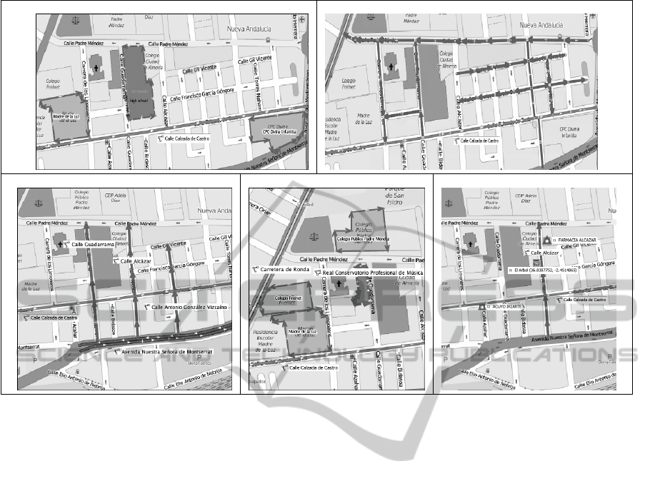
Example 1 Example 5
Example 2 Example 3 Example 4
Figure 7: Results for Examples.
and ways close to “Calzada de Castro” street (i.e.,
those objects whose MBR’s overlap with the MBR of
“Calzada de Castro” street).
Example 2. Retrieve the streets crossing “Calzada de
Castro” and ending to “Avenida Montserrat” street:
let $waysCrossing :=
fn:filter(
rt:getLayerByName(.,"Calle Calzada de Castro"),
osm:isCrossing(?, osm:getOneWay(., "Calle Calzada de Castro")))
return
fn:filter($waysCrossing,
osm:isEndingTo(?, osm:getOneWay(., "Avenida Montserrat")))
Here, the function filter has been used in
combination with the OSM operators isCrossing
and isEndingTo. In this query, first of all the streets
crossing “Calzada de Castro” street are filtered,
and then, from these streets, the streets ending to
“Avenida de Montserrat” street are filtered.
Example 3. Retrieve the schools close to a street,
wherein “Calzada de Castro” street ends.
let $waysAllEndingTo :=
fn:filter(
rt:getLayerByName(.,"Calle Calzada de Castro"),
osm:isEndingTo(osm:getOneWay(., "Calle Calzada de Castro"),?))
return
fn:filter(
fn:for-each($waysAllEndingTo, rt:getLayerByOneWay(.,?)),
osm:searchTags(?,"school"))
Here, we can see how both kinds of queries can
be combined: on the one hand, the OSM operator
isEndingTo is used to get the streets wherein
“Calzada de Castro” street ends, and, on the other
hand, the keyword school from the nodes occurring
in the layer of each street is searched. filter is used
twice.
Example 4. Retrieve the streets close to “Calzada de
Castro” street, in which there is a supermarket “El
Arbol” and a pharmacy (or chemist’s).
osm:intersectionQuery(
osm:unionQuery(
rt:getLayerByName(.,"El Arbol"),
rt:getLayerByName(.,"pharmacy")),
rt:getLayerByName(.,"Calle Calzada de Castro"))
Here, we can see an additional feature of
our library; i.e. the handling of set-based op-
erators, such as union, intersection and
difference of sequences. Functions unionQuery,
intersectionQuery and exceptQuery of the
library can be used to produce more complex queries.
In this case, the intersection of streets close to
“Calzada de Castro” street with a supermarket
(named “El Arbol”) and a pharmacy is requested.
Example 5. Retrieve the streets to the north of
“Calzada de Castro” street:
fn:filter(
GISTAM2015-1stInternationalConferenceonGeographicalInformationSystemsTheory,ApplicationsandManagement
68
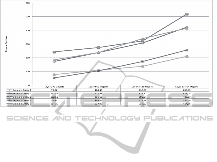
Figure 8: Benchmarking of examples for datasets of different sizes.
rt:getLayerByName(.,"Calle Calzada de Castro"),
osm:furtherNorthWays(
osm:getOneWay(., "Calle Calzada de Castro"),?))
Finally, we can see the use of geo-positioning
queries. Streets close to “Calzada de Castro” street
are obtained, and then, the further north streets are fil-
tered.
4.1 Benchmarks
Now we would like to show the benchmarks obtained
from the previous examples, for datasets of different
sizes. We have used the BaseX Query processor in a
Mac Core 2 Duo 2.4 GHz. All benchmarking proofs
have been tested using a virtual machine running Win-
dows 7 since the JTS Topology Suite is not available
for Mac OS BaseX version. Benchmarks are shown in
milliseconds in Figure 8.
We have tested Examples 1 to 5 with sizes rang-
ing from two hundred to fourteen thousand objects,
corresponding to: from a zoom to “Calzada de Cas-
tro” street to the whole Almer
´
ıa city map (around 10
square kilometers). From the benchmarks, we can
conclude that increasing the map size, does not in-
crease, in a remarkable way, the answer time.
Unfortunately, we cannot compare our bench-
marks with existent implementations of similar tools
due to the following reasons. Even when OSM has
been used for providing benchmarks in a recent work
(Eiter et al., 2014), they use OSM as dataset for De-
scription Logic based reasoners rather than to evaluate
spatial queries. There are some proposals for defining
spatial datasets for benchmarking Spatial RDF stores
(Kolas, 2008; Garbis et al., 2013), mainly focused on
Clementini’s and Egenhofer’s operators whereas our
query language offers more sophisticated queries.
5 RELATED WORK
GQuery (Boucelma and Colonna, 2004) is a pro-
posal for adding spatial operators to XQuery. Ma-
nipulation of trees and sub-trees are carried out by
XQuery, while spatial processing is performed using
geometric functions and JTS. GeoXQuery approach
(Huang et al., 2009) extends the Saxon XQuery pro-
cessor (Kay, 2008) with function libraries that pro-
vide geo-spatial operations. It is also based on JTS
and provides a GML to SVG transformation library
for the XQuery processor in order to show query re-
sults. GML Query (Li et al., 2004) is also a contribu-
tion in this research line that stores GML documents
in a spatial RDBMS. This approach performs a sim-
plification of the GML schema that is then mapped to
its corresponding relational schema. The basic val-
ues of spatial objects are stored as values of the ta-
bles. Once the document is stored, spatial queries can
be expressed using the XQuery language with spatial
functions. The queries are translated to their equiva-
lent in SQL which are executed by means of the spa-
tial RDBMS.
Linked Geospatial Data is an emerging line of re-
search (see (Koubarakis et al., 2012) for a survey) fo-
cused on the handling of RDF based representation
QueryingOpenStreetMapwithXQuery
69

of geo-spatial information, adopting a Semantic Web
point of view (Egenhofer, 2002), and using SPARQL
style query languages like SPARQL-ST (Perry et al.,
2011), stSPARQL (Koubarakis and Kyzirakos, 2010)
and GeoSPARQL (Battle and Kolas, 2012). The
LinkedGeoData dataset (Stadler et al., 2012) is a work
of the AKSW research group at the University of
Leipzig that uses GeoSPARQL and well-known text
(WKT) RDF vocabularies to represent OSM data.
In our approach, we have followed the same direc-
tion as (Boucelma and Colonna, 2004; Huang et al.,
2009; Li et al., 2004), adopting XQuery for querying,
but they are not focused on OSM, and higher order
functions are not used. With regard to OSM3S (i.e.,
Overpass API), it is specifically designed for search
criteria like location, types of objects, tag values,
proximity or combinations of them. Overpass API
has the query languages Overpass XML and Over-
pass QL. Both languages are equivalent. They handle
OSM objects ((a) standalone queries) and set of OSM
objects ((b) query composition and filtering). With re-
spect to (a), the query language allows the expression
of queries in order to search a particular object, and is
equipped with forward or backward recursion to re-
trieve links from an object (for instance, it allows to
retrieve the nodes of a way). With respect to (b), the
query language allows the expression of queries using
several search criteria. Among others, it can express:
to find all data in a bounding box (i.e., positioning), to
find all data near something else (i.e., proximity), to
find all data by tag value (exact value, non-exact value
and regular expressions), negation, union, difference,
intersection, and filtering, with a rich set of selectors,
and by polygon, by area pivot, and so on. However,
Overpass API facilities (i.e., query composition and
filtering) cannot be combined with spatial operators
such as Clementini’s crossing or touching. In Over-
pass API, only one type of spatial intersection is con-
sidered (proximity 0 by using across selector). For
instance, the query (allowed in our library) ”Retrieve
the streets crossing Calzada de Castro street and end-
ing to Avenida de Montserrat street” is not allowed
in Overpass API. On the other hand, Overpass API
has a rich query language for keyword search based
queries. We plan to extend our library to handle a
richer set of keyword search based queries.
SPARQL based query languages offer a rich
set of spatial operators. For instance stSPARQL
(Koubarakis and Kyzirakos, 2010) is equipped with
Clementini’s operators, as well as MBRs based oper-
ators. Also directional operators are considered and,
functions for constructing new objects are included:
buffer, boundary, envelope, convexHull, union, inter-
section and difference as well as distance-based op-
erators: distance and area. Finally, temporal opera-
tors are also considered. The RDF representation of
OSM and the use of SPARQL style query languages,
offer also the opportunity to describe more complex
queries than OSM3S and XAPI. The use of XQuery
for OSM data makes sense when the XML represen-
tation of an OSM layer is the input of a query, and
the answer is also required in XML format; for in-
stance, when using JOSM to visualize OSM maps.
Unfortunately, SPARQL and its spatial dialects are not
equipped with Higher Order (although there exists a
recent proposal (Atzori, 2014) for SPARQL) and thus,
the queries that we can propose, are impossible to ex-
press in them. Even more, spatial dialects of SPARQL
have to deal with the graph based structure of OSM
RDF, that sometimes can make it more difficult, if not
impossible, the expression of some queries (Alkha-
teeb et al., 2011). The same can happen when us-
ing a spatial DBMS and OSM data are imported to it.
While spatial DBMS can offer the same functional-
ity than the proposed XQuery extension, higher order
facilities makes the work easier.
6 CONCLUSIONS AND FUTURE
WORK
We have presented an XQuery library for querying
OSM. We have defined a set of OSM Operators suit-
able for querying points and streets from OSM. We
have shown how higher order facilities of XQuery
enable the definition of complex queries over OSM
involving composition and keyword searching. We
have provided some benchmarks using our library that
take profit from the R-tree structure used to index
OSM. As future work firstly, we would like to ex-
tend our library to handle closed ways of OSM, in
order to query about buildings, parks, etc. Secondly,
we would like to enrich the repertoire of OSM oper-
ators for points and streets: distance based queries,
ranked queries, etc. Finally, we would like to develop
a JOSM plugin, as well as a Web site, with the aim
to execute and to show results of queries directly in
OSM maps.
ACKNOWLEDGEMENTS
This work was funded by the EU ERDF and the
Spanish Ministry of Economy and Competitiveness
(MINECO) under Project TIN2013-44742-C4-4-R,
and by the Andalusian Regional Government (Spain)
under Project P10-TIC-6114.
GISTAM2015-1stInternationalConferenceonGeographicalInformationSystemsTheory,ApplicationsandManagement
70

REFERENCES
Alkhateeb, F., Baget, J.-F., and Euzenat, J. (2011). Ex-
tending SPARQL with regular expression patterns (for
querying RDF). Web Semantics: Science, Services
and Agents on the World Wide Web, 7(2):57–73.
Atzori, M. (2014). Toward the Web of Functions: Interop-
erable Higher-Order Functions in SPARQL. In The
Semantic Web–ISWC 2014, pages 406–421. Springer.
Bamford, R., Borkar, V., Brantner, M., Fischer, P. M., Flo-
rescu, D., Graf, D., Kossmann, D., Kraska, T., Mure-
san, D., Nasoi, S., et al. (2009). XQuery reloaded.
Proceedings of the VLDB Endowment, 2(2):1342–
1353.
Battle, R. and Kolas, D. (2012). Enabling the geospatial
semantic web with Parliament and GeoSPARQL. Se-
mantic Web, 3(4):355–370.
Berglund, A., Boag, S., Chamberlin, D., Fernandez, M.,
Kay, M., Robie, J., and Sim
´
eon, J. (2010). XML path
language (XPath) 2.0. W3C.
Boucelma, O. and Colonna, F. (2004). GQuery: a Query
Language for GML. In Proc. of the 24th Urban Data
Management Symposium, pages 27–29.
Clementini, E. and Di Felice, P. (2000). Spatial operators.
ACM SIGMOD Record, 29(3):31–38.
Egenhofer, M. J. (1994). Spatial SQL: A Query and Pre-
sentation Language. IEEE Trans. Knowl. Data Eng.,
6(1):86–95.
Egenhofer, M. J. (2002). Toward the semantic geospatial
web. In Proceedings of the 10th ACM international
symposium on Advances in geographic information
systems, pages 1–4. ACM.
Eiter, T., Schneider, P.,
ˇ
Simkus, M., and Xiao, G. (2014).
Using OpenStreetMap Data to Create Benchmarks for
Description Logic Reasoners. In Proceedings of the
3rd International Workshop on OWL Reasoner Eval-
uation (ORE 2014), pages 51–57. CEUR Workshop
Proceedings, Vol-1207.
Garbis, G., Kyzirakos, K., and Koubarakis, M. (2013). Ge-
ographica: A Benchmark for Geospatial RDF Stores.
In The Semantic Web–ISWC 2013, pages 343–359.
Springer.
Grun, C. (2015). BaseX. The XML Database. http:// ba-
sex.org.
Hadjieleftheriou, M., Manolopoulos, Y., Theodoridis, Y.,
and Tsotras, V. J. (2008). R-Trees–A Dynamic In-
dex Structure for Spatial Searching. In Encyclopedia
of GIS, pages 993–1002. Springer.
Haklay, M. and Weber, P. (2008). Openstreetmap: User-
generated street maps. Pervasive Computing, IEEE,
7(4):12–18.
Huang, C.-H., Chuang, T.-R., Deng, D.-P., and Lee, H.-
M. (2009). Building GML-native web-based geo-
graphic information systems. Computers & Geo-
sciences, 35(9):1802–1816.
Kay, M. (2008). Ten reasons why saxon xquery is fast.
IEEE Data Eng. Bull., 31(4):65–74.
Kolas, D. (2008). A Benchmark for Spatial Semantic Web
Systems. In International Workshop on Scalable Se-
mantic Web Knowledge Base Systems.
Koubarakis, M., Karpathiotakis, M., Kyzirakos, K., Niko-
laou, C., and Sioutis, M. (2012). Data Models and
Query Languages for Linked Geospatial Data. In
Reasoning Web. Semantic Technologies for Advanced
Query Answering, pages 290–328. Springer.
Koubarakis, M. and Kyzirakos, K. (2010). Modeling and
querying metadata in the semantic sensor web: The
model stRDF and the query language stSPARQL. In
The semantic web: research and applications, pages
425–439. Springer.
Li, Y., Li, J., and Zhou, S. (2004). GML Storage: A Spatial
Database Approach. In Wang, S., Yang, D., Tanaka,
K., Grandi, F., Zhou, S., Mangina, E. E., Ling, T. W.,
Song, I.-Y., Guan, J., and Mayr, H. C., editors, ER
(Workshops), volume 3289 of Lecture Notes in Com-
puter Science, pages 55–66. Springer.
Meier, W. (2003). eXist: An open source native XML
database. In Web, Web-Services, and Database Sys-
tems, pages 169–183. Springer.
Perry, M., Jain, P., and Sheth, A. P. (2011). SPARQL-
ST: Extending SPARQL to support spatiotemporal
queries. In Geospatial semantics and the semantic
web, pages 61–86. Springer.
Robie, J., Chamberlin, D., Dyck, M., and Snelson, J.
(2014). XQuery 3.0: An XML query language. W3C.
Shekhar, S. and Xiong, H. (2008). Java topology suite (jts).
In Encyclopedia of GIS, pages 601–601. Springer.
Stadler, C., Lehmann, J., H
¨
offner, K., and Auer, S. (2012).
Linkedgeodata: A core for a web of spatial open data.
Semantic Web, 3(4):333–354.
QueryingOpenStreetMapwithXQuery
71
