
A Digital Library System for Semantic Spatial Information
Extraction from Images
Michalis Foukarakis
1
, Lemonia Ragia
2
and Stavros Christodoulakis
3
13
School of Electronic and Computer Engineering, Technical University of Crete, Kounoupidiana, Chania, Greece
2
School of Architectural Engineering, Technical University of Crete, Kounoupidiana, Chania, Greece
Keywords: Semantic Extraction, Spatial Context, Image, Camera, Sensors.
Abstract: Spatial information delivery is of high importance today for mobile applications. Knowledge about spatial
objects includes not only location of the user, direction and time, but also knowledge of the semantics of the
spatial objects. These semantics can be related to the user profile and user’s interests at the time, which can
be expressed using domain specific ontologies, such as cultural ontologies, nature ontologies,
tourism ontologies and others. The system then should screen this information and deliver it to the mobile
user device. The system uses as input digital images taken from a simple, modern digital camera. In this
paper we present a digital library system for image storage, image handling and extraction of spatial
information based on the semantics spatial information that the system manages.
1 INTRODUCTION
Cameras as powerful tools can be specific capturing
devices. We are not discussing professional metric
cameras from the scientific area of photogrammetry
but simple cameras which are supported by other
devices and sensors. Modern digital cameras can
cooperate with GPS, camera orientation with
respect to the geographic directions (north, south,
etc.), distance measuring devices, camera directional
(tilt, rotation, etc.). They can have Wi Fi access
capabilities, and send the images to remote
computers, or access information from information
sources, including GIS information, related to the
location or the objects of interest to them. In
summary, they can act as very powerful input
sensors, not just cameras. They can record the
images together with position, direction, tilt and
other parameters, which can be useful metadata for
the image annotation. Subsequently, they enable
different kinds of new applications.
The high focusing, zooming, resolution, and
color range capabilities of the digital cameras makes
their images extremely useful. The user can manage
to extract automatic or semi-automatic spatial
information and manipulate the contents of the
images. These capacities provide powerful
capabilities for several important application
environments for personal and community shared
use. The capabilities for clearer identification of
objects within images allow a better automatic or
semiautomatic communication with other
information resources (like GISs, cultural and
tourism digital libraries, etc.) To explore the images’
full potential in document management applications,
we need to integrate them with other sensors, as well
as with other data types, applications, and services.
In this paper, we present a system for spatial
information extraction, for management of images of
a Digital Library based on the user context. This
work exploits the modern digital cameras' potential
for capturing contextual parameters through the use
of sophisticated sensor devices, information found in
specially annotated semantic maps and industrial
standards. The system implementation provides an
image database that allows users to store and view
their images. Along with the images, the users can
view personalized semantic maps, annotated with
semantic objects described using ontologies. These
maps are supplied from a remote server. The
objective is to effectively manage and associate the
spatial information and semantic objects contained
in both the semantic maps and the images. In
addition, the system uses several algorithms to
Foukarakis M., Ragia L. and Christodoulakis S..
A Digital Library System for Semantic Spatial Information Extraction from Images.
DOI: 10.5220/0005365901650169
In Proceedings of the 1st International Conference on Geographical Information Systems Theory, Applications and Management (GISTAM-2015), pages
165-169
ISBN: 978-989-758-099-4
Copyright
c
2015 SCITEPRESS (Science and Technology Publications, Lda.)

enable the automatic annotation of the images.
Images with position only information or both
position and direction information can be visualized
on top of the maps and be associated with semantic
objects. We demonstrate our system providing
examples from the domain of tourism, archaeology,
and tourism related to coastal erosion problems,
emphasizing the practical applications of this work.
2 RELATED WORK
The paper is based on standards and software that
already exist and are widely used: Exif and NMEA
0183 (Exif 2010, NMEA 0183 2002). Google Earth
is a platform for geographic data which provides
flexibility and lots of useful functionalities for
spatial information processing (Google Earth 2014).
There are examples from the industry that handle a
massive amount of images and annotate, retrieve and
organize lots of images like Picasa (Google) and
Flickr (Yahoo!). Other prototypes propose
technologies to improve and facilitate image
retrieval and organization for personal use (Naaman
et al, 2005, Viana et al., 2011).
The usage of ontology terms to describe
semantic content of images has been discussed
(Hyvönen et al., 2002, Kallergi et al., 2009). Image
annotation using ontologies has been introduced in
different approaches demonstrating the important
role of the ontologies for better image understanding
and querying (Bannour and Hudelot, 2011). Other
approaches propose the usage of semantics for
image retrieval (Vogel and Schiele, 2007).
In this paper we emphasize the idea to integrate
the captured contextual information on a digital
image which has been taken from the digital camera
at the same time with the image (context of
capturing). The retrieval and the visualization of the
personalized semantic information based on the user
context can then be supported by the system.
3 SEMANTIC SPATIAL
INFORMATION PROCESSING
Semantic information processing and semantic
interoperability with other applications in a service
oriented infrastructure is of central importance to the
industry today. Use of industrial standards in the
different application domains, as well as use of
community accepted ontologies are needed in such
an environment. Interoperability support using
ontologies and standards is also very important in
the open internet environment today.
The main characteristics that the system is based
on are:
1. Semantic information processing
2. Semantic interoperability with other
applications in a service oriented
infrastructure
3. Use of industrial standards
4. Use of community accepted ontologies
5. Automatic image annotation
6. Personalization
7. Simplicity and automation in the information
capturing
The objective is to create the infrastructure for
integrated transparent management of semantic
spatial multimedia information that includes maps,
semantic objects in maps, images and semantic
objects of the spatial environment captured in
images. The system takes into account multi-sensor
digital camera capabilities and semantic spatial
information encoded in semantic maps to
automatically associate digital image contents with
semantic spatial information and allow powerful
functionality and visualizations.
Applications implementing the main ideas
presented here have been developed. The system
utilizes a modern digital camera integrated with a
sensor capturing position and direction parameters
and processes the information embedded in the
images in order to associate image contents with
semantic information located in semantic maps.
The application provides a simple interactive
map interface and the ability to visualize objects of
interest and photos on top of the map. The user can
select and view information about semantic objects
contained in pictures and also view detailed picture
information located either in the image metadata or
provided by the system's automatic annotation
capability.
Viewable information about a semantic
object includes:
Name
Semantic type (for example "St. Nikolaos
Church" can be of type Church)
Domain (or ontology - for example "Knossos
Ruins" belongs to the Archaeology domain)
Description
Map representation (as a geometric shape)
List of images depicting the semantic object
Viewable information about an image includes:
The image itself
Metadata (camera model/make, date, focal
length, comments etc.).
Semantic objects contained in the image (as
either a list or superimposed on the image if
possible).
Map representation (using a circle to represent
position and a conic shape to represent
direction and angle of view).
To provide the above functionalities and
visualizations, various algorithms have been
implemented. The system implementation stores the
images and the semantic maps in a relational
database (Christodoulakis et al,. 2009) and provides
retrieval functionality for both. The maps are
acquired from a semantic map server and can be
personalized according to user interests. For
example, if the user is interested in the
archaeological or cultural sites of Crete but not in its
geographic features, the server can then provide a
version of the map of Crete without the geographic
semantic objects. Ontologies play an important role
in our system. The system is interactive and the user
can add its personal ontology tree where ontologies
have a number of semantic types and semantic
objects belong to these types, forming a hierarchy.
Figure 1: High resolution image segmentation with the
single detected sky region. The algorithm has merged the
regions that were not smooth, creating a single region for
the sky. The skyline can then be easily extracted to be
used for image registration and produce the final result.
A very important functionality of the system is
that it associates map information with the
geospatial parameters recorded in the images,
transforming them into interactive windows to the
outside world. We have adopted the approach
described in Christodoulakis et al., 2010 to
accomplish this. This approach calculates the 2D
spatial view from the position and direction of image
taking and then with a defined procedure that
includes image segmentation (Figure 1), region
recognition and image registration, it allows the
visualization of (interactive) semantic objects and
their location in the image by superimposing their
shapes on top of the image.
4 APPLICATIONS
The user interface of the software that has been
developed to demonstrate some aspects of the
functionalities offered by the system is shown in
Figure 2. The user can impose constraints on what
type of semantic objects are of interest (according to
their hierarchy) and the system will only show
objects that satisfy the constraints. The user can
request to see all semantic object footprints that are
visible for a given image, according to the image’s
location and direction. The user can also receive a
list of images that depict a specific semantic object.
Viewing the images on top of the map and
information on each semantic object present is also
supported.
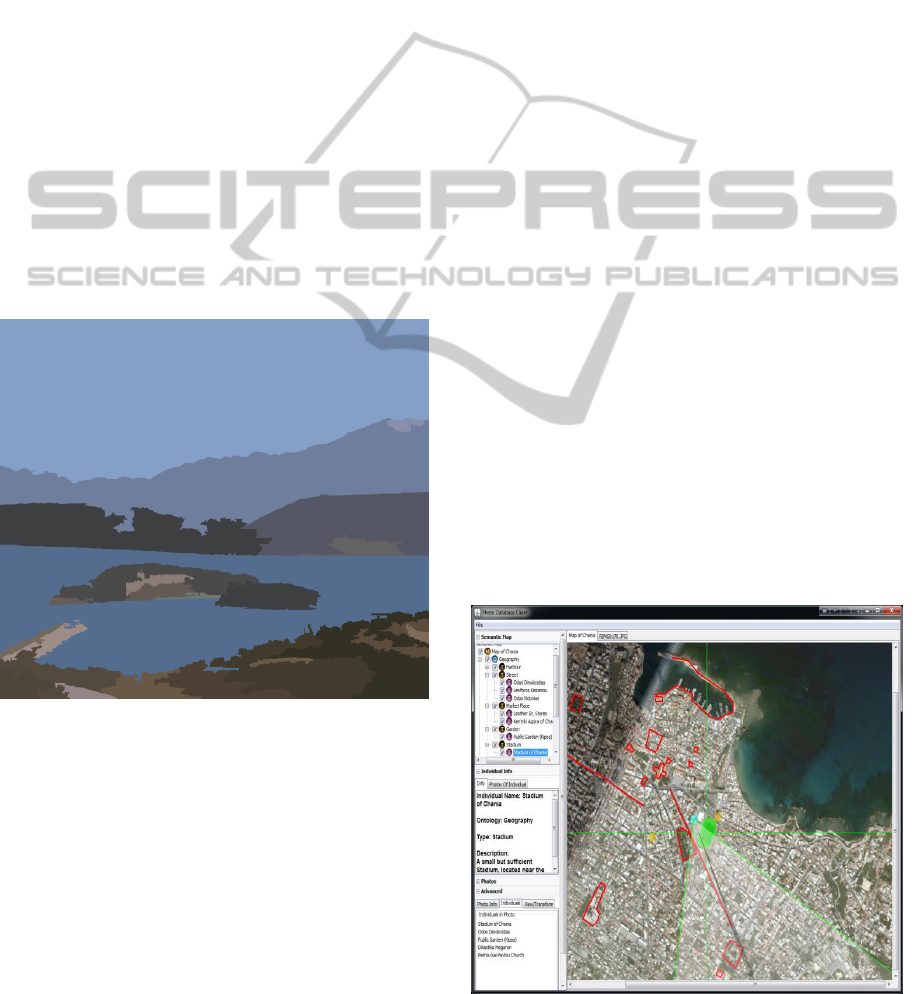
We explored the usefulness of the system in the
tourism domain. A semantic map of the city of
Chania was used and the knowledge base contained
semantic objects that describe tourist attractions,
useful locations, churches and known roads. After
taking images of the city using a modern digital
camera equipped with location and direction sensors,
the images were transferred to the system’s database
and were automatically annotated with information
from the semantic map. The image contents could
then be queried upon.
Figure 2: An example of the system user interface.
The location from which the pictures where taken
and the direction of the pictures can also be
displayed on top of the map.
Another very useful application where we can use
our system is to show the coastal erosion related to
tourism areas. The data for the coastal erosion can
be fed from local authorities and the user of the
system can import his/her private images with GPS
information and image metadata. The location of
interesting hotels in connection with their private
beaches can be displayed on the semantic maps and
the user can have additional information about the
current status of the beach. For example, a
comparison between the new data of semantic maps
about the sea level rise from the local offices with
the individual images can immediately depict areas
where an indirect erosion and loss in beach sand
coexist. Another application of our system can be
the display of the existing sea level rise along the
open coastal areas where specific human activities
are reduced. The main advantages of our system in
such an application is to find answers to individual
questions. The system has a friendly user interface
which enables the users to integrate data from
external resources and import their own private data.
Then a personal scenario about interesting subjects
can be created
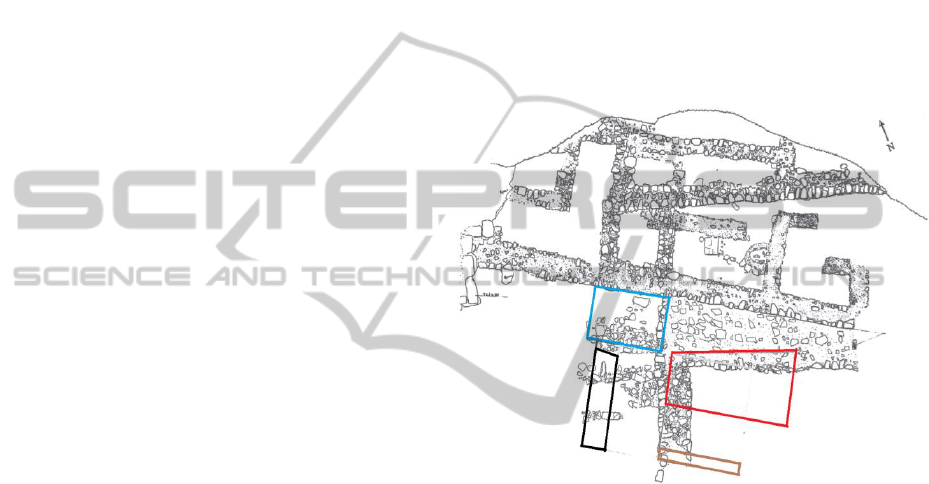
In an application of cultural heritage, the system
can also be used to efficiently manage, interpret and
incorporate spatial information. Several benefits
could be obtained with the usage of our approach: a)
Existing documentation can be imported and
visualized in this work. Cultural heritage
documentation consisting of images, drawings and
sketches can be retrieved and saved. For example,
existing drawings that show an archaeological site
can be represented as a semantic map. The footprint
of an archaeological monument can be visualized in
an existing map. Images with contextual metadata
that display an ongoing excavation can be
downloaded and visualized with other related
documentation. Retrieval matching can be based on
spatial information but also on semantic descriptions
related to a semantic map. Note that in this
application more than one semantic map may exist,
for example showing the same location at different
time intervals. Figure 3 shows an archaeological
drawing that has been processed and converted into
a semantic map Entities such as rooms, walls,
buildings etc. that are in the knowledge base and
contain GPS coordinates are drawn and visualized
on top of the map. b) Multiple data can be
simultaneously processed and saved. Using the old
and new taken images with the GPS information,
inconsistencies about an object of interest, e.g.
archaeological monument, can be detected and
identified. c) An efficient analysis requires some
kind of data organization that can be realised in this
system. An appropriate analysis of relationships
among spatial data from different sources can be
performed. A query makes use of spatial and
temporal criteria combining context of
archaeological data. For example, a personalized
Semantic Map reflecting the interests of a user can
include all the digital images with the context of
“restoration of all Byzantine archaeological
monuments that happened in the last year”.
Figure 3: An archaeological drawing converted into a
semantic map with semantic object footprints. Drawing
taken from Kanta et al., 2012.
5 CONCLUSIONS
The system presented in this work provides an
integrated transparent management of semantic
spatial information processing. A basic contribution
of this work is that integration of inexpensive
sensors with the camera is now feasible and it can
result in semantic management of image contents.
The main advantages of the system are its adoption
of industrial standards and commonly used
ontologies for the purpose of image annotation and
the association of semantic map spatial information
with the images.
The system uses automatically captured
parameters by GPS and compass as well as
contextual knowledge from 3D maps and geographic

ontologies to produce good 2D representations of the
scene visible in the direction of the camera.
In conclusion, the system provides a rich,
transparent, and integrated functionality for
managing a personal database of digital images and
digital maps, in a semantic spatial information
extraction. The images are associated with semantic
objects present in semantic maps, events defined by
the users and persons participating in these events.
The contents of the database can then be seen as an
interactive living memory of the trips or activities
performed by the users, even years after the
completion of these events.
Current work in this area involves the accurate
registration of the images captured by the camera to
detailed earth elevation data so that far objects in
distance can be automatically and accurately located
on top of pictures. Experimentation in different
settings is important to validate the results.
ACKNOWLEDGMENTS
The authors gratefully acknowledge support from
the EU project ASTARTE - Assessment, STrategy
And Risk Reduction for Tsunamis in Europe. Grant
603839, 7th FP (ENV.2013.6.4-3).
REFERENCES
Bannour, H., Hudelot, C., 2011. Towards ontologies for
image interpretation and annotation. 9th International
Workshop on Content-Based Multimedia Indexing
(CBMI), pp. 211-216, Madrid, Espagne.
Christodoulakis, S., Foukarakis M., and Ragia L., 2009.
Personalised spatial knowledge management for
pictures using ontologies and semantic maps.
International Journal of Digital Culture and Electronic
Tourism 1.4: pp. 346-356.
Christodoulakis, S., Foukarakis, M., Ragia, L., H.
Uchiyama H., and Imai T., 2010. Mobile picture
capturing for semantic pictorial database context
access, browsing and interaction. IEEE Mulimedia,
Mobile and Ubiquitous Multimedia, pp. 34-41.
Exif, 2010. Exhangeable Image File Format.
http://en.wikipedia.org/wiki/Exchangeable_image_file
_format
Google Earth, 2014. Google Earth virtual globe.
http://earth.google.com.
Hyvönen E., Styrman A., Saarela, S., 2002. Ontology–
based image retrieval. In Towards the semantic web
and web services, Proceedings of XML Finland
Conference, pp. 15-27.
Kallergi, A., Bei, Y., Verbeek, F.J., 2009. The Ontology
Viewer: Facilitating image annotation with ontology
terms in the CSIDx imaging database. Proceedings
VISSW, CEUR-WS Proceedings Vol. 443.
Kanta, A., Tzigounaki, A., Godart, L., Pecoraro, G.,
Mylona, D., and Speliotopoulou. A., 2012.
MONASTIRAKI IIA The archive building and
associated finds.
Naaman, M., Yeh, R.B., Garcia-Molina H., Paepcke, A.,
2005. Leveraging context to resolve identity in photo
albums. In Proceedings of the Fifth ACM/IEEE-CS
Joint Conference on Digital Libraries (JCDL 2005),
Jne 7-11, Denver, Colorado.
NMEA 0183, 2002. NMEA 0183 electrical and data
specification for communication.
http://www.nmea.org/pub/0183/index.html.
Viana, W., Miron, W., Moisuc, A.D., Gensel, B., J.,
Villanova-Oliver M., and Martin H., 2011. Towards
the semantic and context-aware management of
mobile multimedia. Multimedia Tools and
Applications, 53.2: 391-429.
Vogel, J., Schiele, B., 2007. Semantic modeling of
natural scenes for content-based image retrieval.
International Journal of Computer Vision, 72.2: 133-
157.
