
Architectural Heritage Semantic Data Managing and Sharing in GIS
Elena Cerutti
1
, Francesca Noardo
2
and Antonia Spanò
1
1
Politecnico di Torino, DAD, viale Mattioli, 39, 10125 Torino, Italy
2
Politecnicodi Torino, DIATI, c.so Duca degli Abruzzi, 24, 10129 Torino, Italy
{elena.cerutti, francesca.noardo, antonia.spano}@polito.it
Keywords: Semantics, Standard, Images, GIS, Interoperability, PostGIS, Cultural Heritage, Architectural Heritage.
Abstract: GIS can be effective instruments for managing Architectural Heritage data, in order to query the data for
preservation purposes and to realize advanced analysis. These capabilities can be improved using some tools
developed by the fields of informatics and internet services such as standards, ontologies and object-
oriented programming. The official standards (languages and models) permit the encoding of data so that
they can be effectively shared and integrated, concurrent with the knowledge and integration of data in
Cultural Heritage (CH). Moreover, an even better interoperability of data can be achieved using open-source
management software that normally features more standard data formats and can be used by everyone.
These tools have been used in the research presented here for managing different kinds of data (spatial, non-
spatial, images) on different views, in a unique database respecting the standards codes. In this way some
schemas have been defined, and they can be exported to reach effective data interoperability.
1 INTRODUCTION
The well-known abilities regarding multi-format,
multi-scale and multi-temporal data management are
essential GIS tools in Cultural Heritage digital
archiving. A number of projects have been
developed in order to prove how GIS tools enhance
storage, analysis, and data processing (Apollonio et
al., 2012; Petrescu, 2007). They have become
important support for any kind of knowledge and
planning phase in the field of CH Preservation and
Protection. Central and local authorities responsible
for Cultural Heritage experienced in creating
complex and integrated GIS and/or WEB-GIS have
recognized these tools as useful aids in the decision-
making phase at different scales (Taboroff, 2000).
The success has mainly been rooted in the
archaeological field, because of the intrinsic spatial
connotation of archaeological data (Wüst, 2004).
Some systems with different purposes have been
well-established for at least fifteen years; Djindjian
(1998) has detected the main archaeological sectors
related to GIS use: archaeological surveys (prevision
of sites location), spatial analyses for territorial
inquiries, Cultural Resource Management for CH
Protection and Preservation, and lastly, intra-site GIS.
In the framework of Architectural Heritage
protection, the GIS services requested are very
similar to those well-established for intra-site GIS.
The similarities reside in the scale of details needed
in both systems, and the large amount of archived
multifaceted heterogeneous data. Furthermore, the
use of GIS is suitable for processing complex and
specialized geometrical entities, allowing them to be
manageable in a 3D spatial context. These are
increasing in number, since in recent years spatial
objects have often been derived from LiDAR or
photogrammetry methods of points model
generation. For all these reasons, specialized
semantic values of database objects are needed.
The management of object meanings is being
developed by other sectors, such as web
technologies. However, some necessary infra-
structure in order to easily implement systems able
to manage this information is missing: the available
ontologies are often incomplete for the overall
management of some kind of CH item, and the
software currently used is not always the best
solution for the implementation of the models.
The convenience of using the building
information modelling (BIM) to manage high-scale
semantic representations has been tested. In this
paper we are going to discuss some issues
concerning the ways in which these needs can be
addressed in GIS, as listed in the framework of
Architectural Heritage.
121
Cerutti E., Noardo F. and Spanò A..
Architectural Heritage Semantic Data Managing and Sharing in GIS.
DOI: 10.5220/0005387801210128
In Proceedings of the 1st International Conference on Geographical Information Systems Theory, Applications and Management (GISTAM-2015), pages
121-128
ISBN: 978-989-758-099-4
Copyright
c
2015 SCITEPRESS (Science and Technology Publications, Lda.)

1.1 Ontologies, Semantic
Representations and
Interoperability Issues
Semantics is the study of meanings, and focuses on
the relation between the signifiers - the symbols
used to communicate a concept - and the meaning of
the concept itself. An essential element of this
discipline is the study of language. For the
exigencies of web communications and automatic
computing, the study of formal languages for
expressing concepts and for relating them to one
another has been developed. This development
carried over to the advancement of ontologies; these
can help to resolve heterogeneities, as they define a
unique frame by making the conceptualisation
unambiguous (Guarino, 2009).
The superabundance of data and its
misinterpretation is a real problem in the CH field.
These issues can lead to the risk of carrying out
incorrect interventions and, consequently, of losing
some valuable CH items (tangible or intangible).
The modelling concepts of information systems
based on domain ontologies (Guizzardi, 2005) can
effectively reduce this risk.
The use of semantics theory to achieve
interoperability and data sharing has been examined
in recent years by the developers of the Semantic
Web, the evolution of the World Wide Web, in
which the meaning of data is managed through its
semantic contents. This development is headed by
W3C (World Wide Web Consortium, www.w3c.org),
an organization that publishes explicit standards.
W3C defined some useful languages for
representing information that are both human and
machine-readable. Markup languages (such as
HTML and XML) allow one to write content and
provide information about which role that content
plays. In particular, XML (www.w3.org/XML/) is a
metalanguage for markup: it provides a uniform
framework, and tools for the interchange of data and
metadata among applications. XML does not
provide any means of talking about the semantics
(meaning) of data. Many software applications use
XML for exporting and exchanging files, but these
files cannot always be read correctly by different
software programs. Even so, XML is the base for
several formal languages that are able to define and
to express semantics in a machine-readable format:
RDF (Resource Description Framework), and OWL
(Ontology Web Language). These can structure the
semantics of data effectively, and can be queried
using query languages like SPARQL.
In spite of these advantages, these languages do
not consider the spatial dimension of data. The
management of spatial information is instead the
primary objective of the OGC (Open Geospatial
Consortium), which has spearheaded several efforts
at defining standards for reaching interoperability
solutions that “geo-enable” the Web. The Mapping
sector also requires more and more data integration
and exchange. The international directives, such as
INSPIRE (INfrastructure for SPatial InfoRmation in
Europe) (http://inspire.ec.europa.eu/), promote the
development of spatial data infrastructures (SDI)
that can rely on the availability of spatial data
standards.
The OGC defined standards explicitly for this
kind of data. One of the basic OGC standards is the
GML (Geographic Markup Language), which is
similar to the XML in structure is intended to
express geographical objects. This is used for the
definition of the standard CityGML, which is a
model for the representation of city objects
(http://www.opengeospatial.org/standards/citygml).
The same language is used for the INSPIRE
UML model, aimed at the harmonisation of digital
maps in Europe. Another important standard
language is the OGC geoSPARQL, which is useful
for managing spatial data.
(http://www.opengeospatial.org/ standards/geosparql)
Some projects have been developed for the
integration of spatial information, in OWL
ontologies using the OGC geoSPARQL. See as an
example for Cultural Heritage the project CRMgeo
(Doerr and Hiebel, 2013).
The successes of standards adoption and sharing
arose thanks to ICT (Information and Communication
Technology) support. For further enhancing
interoperability, open source tools are nowadays
increasingly of interest in different environments,
including CH. The Open Source Geospatial Foundation
collects the most popular Open Source GIS projects, and
they refer to standards of the Open Geospatial
Consortium (OGC). Examples of GIS tools employed in
the CH framework are: GRASS-GIS (Geographic
Resources Analysis Support System), QuantumGIS,
with a user-friendly graphical interface, SAGA GIS,
System for Automated Geoscientific Analyses,
MapWindow for modelling and analysis, and ILWIS
GIS (Integrated Land and Water Information System)
with image analysis and photogrammetric functions.
1.2 Architectural Framework Needs
and Standards Availability
The Historical Architectural Heritage is subject to
continuous use, and, over time, to maintenance,
repair and restoration. As such, it is essential to be
able to document and record dynamic
GISTAM2015-1stInternationalConferenceonGeographicalInformationSystemsTheory,ApplicationsandManagement
122

transformations in order to allow for continuous
updating and monitoring. A multiplicity of
heterogeneous information must be stored according
to the relation of specific parts of cultural artefacts.
Concurrent with these archiving requirements, the
need for data meanings management arises;
meanings are needed in order to unambiguously
interpret, share and correctly exchange information.
It is obvious that the implementation of accessible
systems using a supported standard for the
management of CH information should be
encouraged.
Some studies about the development of some
semantic GIS have been performed, beginning in the
mid-1990s (Mennis, 2003; Fonseca et al., 2002). In
these studies, an object-oriented approach was used
as an effective solution for expressing and storing
the data meanings (Scholl, 1992). In this way, even
more powerful systems could be built with
significant data interoperability and a reduction of
any potential ambiguity.
The international CH institutions, including
UNESCO, ICOMOS, ICOM-CIDOC, CIPA and the
Getty Conservation Institute, as well as the ISCR
(Istituto Superiore per la Conservazione e il
Restauro) in Italy, have made significant efforts in
developing guidelines, recommendations, ontologies
and structured vocabularies to construct this
complex framework. It is possible to identify some
effective standards applied to CH that have been
tested with good results. For many subsectors of the
Cultural Heritage field, such as museum archives
and photo inventories, some standard data models
have been defined in spite of continuing uncertainty
regarding a more general framework. For example,
MIDAS Heritage, developed by the Historic
Buildings and Monuments Commission for England,
is a free data standard available for recording
information about CH. It adopts INSCRIPTION, a
collection of wordlists for monument classification.
Category for the Description of Works of Arts
(CDWA), defined by the Getty Research Institute,
describes the content and format for the records of
art databases, including architecture. In the Italian
framework, some efforts have been made by the
Commissione NorMaL (NORmalizzazione Materiali
Lapidei) in the field of monument restoration to
define unified methodologies and specifications for
materials preservation. These guidelines are to
become standard UNI (Italian) and aim to be
recognized in Europe (NorMaL, 2006).
Moreover, the CIDOC (International Committee
for Documentation) of the ICOM (International
Council of Monuments) has defined what is
considered the core ontology for Cultural Heritage:
CIDOC – CRM (Conceptual Reference Model)
(Doerr et al., 2007), which became the standard ISO
21127. It is defined using OWL, and is a formal
ontology for exchanging cultural heritage
information and enabling semantic inferences. An
enhancement of CIDOC-CRM is MONDIS
(Monument Damage Information System) (Blaško et
al., 2012; Cacciotti et al., 2013), the ontology
developed for specializing the CIDOC CRM in the
field of preservation, restoration and intervention. It
also uses OWL for the encoding of the schema.
In recent years, the institutions cited, as along
with the World Monument Fund, have risen to the
challenge of filling in many “CH inventories” -
essentially, Cultural Resource Management - in
order to improve the effectiveness of Heritage
Protection. Such inventories are valuable for public
administration action plans, for specialized research,
for tourist attractions, and generally to promote
cultural awareness. An example of substantial GIS
support aimed to effectively exploit heritage
inventories is the ARCHES project, which invites
specialized users to upload data regarding any assets
across the globe (http://archesproject.org, Myers et
al., 2013).
However, the assets’ data are located on maps
using satellite or small-scale vector web maps; these
kinds of representation are useful for representing
partial or whole regions. These maps are usually not
adequate for representing the assets with the
appropriate level of detail, or from the necessary
point of view. Moreover, these standard models
currently lack integration between spatial and
attribute data for many fields of application.
1.3 Proposal Aims
In this research effort, we modelled a GIS structure
by integrating different spatial and thematic standard
data-models in order to effectively represent the
information in a chosen case study.
The main purposes of our work include the
representation of different aspects and points of
view, the use of various levels of detail concerning
built structures, and the addition of relations with the
landscape context. These aims have been achieved
through the use of different spatial maps, so that
digital regional maps and orthophotos representing
the building fronts, or vector graphic drawings
representing features of facades, can be visualized
separately while remaining stored in a unique
geodatabase.
Our intention is to provide a system in which
information concerning the architectural elements
and their measurable morphology, material decay,
ArchitecturalHeritageSemanticDataManagingandSharinginGIS
123
eventual repair interventions and non-routine
maintenance works can be related with the purpose
of better coordinating the planning phases of
restoration and monitoring activities.
Moreover, the ontological models used follow an
object-oriented structure, which offer several
advantages in representation (such as the possibility
of managing inheritance or polymorphism, essential
characteristics for a multi-scale approach). This is
the reason why we choose the open-source software
PostgreSQL, an object-relational database
management system (ORDMBS), with a spatial
extension (PostGIS).
2 SYSTEMS ENHANCING CH
KNOWLEDGE AND
PRESERVATION PLANS
The interconnection and cooperation of experts and
authorities responsible for CH is a key feature of CH
preservation. For this reason, the increase in
availability of systems able to advance stakeholders’
interactions is significant (Rodríguez et al., 2014).
The goal is the sharing of effort and resources to
address planned actions and financing decisions, so
as to encourage stakeholders to become actively
engaged in preservation processes.
When dealing with CH items one must face
problems of heterogeneity of data from multiple
points of view. The relevant fields of study are
numerous; the formats of data may be different
(vector data, raster data, alphanumeric data tables,
text documents, and so on), and different sources
can provide very different data. At different times in
the history of CH, situations can change. Moreover,
it is important to represent these objects at different
levels of detail for a multi-scale approach; similarly,
different surfaces of the same object that are not
necessarily coplanar must be depicted.
To fulfil these requirements successfully, a
conceptual model derived from multiple self-
integrated standard data models has been chosen.
Particular care has been taken to choose the software
in which this model is implemented.
2.1 The Spatial Object-relational
Database Modelled on an
Integrated Standard
Existing standards for data models correspond to
specific fields of application, and it is unusual to
find a comprehensive model appropriate for all the
features of multidisciplinary and multifaceted fields
like Cultural Heritage. For this reason it is necessary
to integrate different data model standards in a
unique conceptual model that suitably represents the
object of study in an exhaustive way from the
perspective of the interested party.
In the example presented, we extracted most of
our spatial entities from CityGML. We then
integrate them with some entities derived from
CIDOC-CRM, which is essential for representing
CH entities (even if the spatial contents must often
be integrated). Moreover, it can be useful for
expressing details at a higher representation scale.
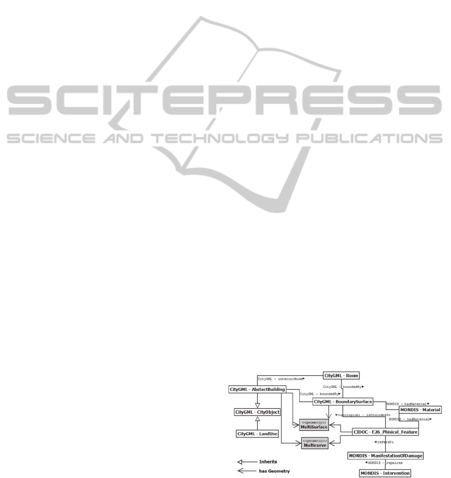
For example E26_Physical_Feature can be
effectively used for mapping the physically damaged
areas on a surface. Doing so is not necessarily
straightforward - “This class comprises identifiable
features that are physically attached to particular
physical objects, but there are no natural borders that
separate them completely in an objective way from
the carrier objects” (Le Boeuf et al., 2013). As these
kinds of details are inherently spatial features, they
have been regarded as such by archiving them in the
database with a geometry attribute. The third key
application field concerning the study object is the
preservation field, modelled by the MONDIS
ontology. The entities extracted from this last one
and related to CIDOC-CRM “E26 Phisical Feature”
are “Material”, “Manifestation of Damage” and the
related “Intervention”. The conceptual model
obtained includes only few entities (Fig. 1), but they
are useful for showing a new approach in modelling
and implementing the GIS.
The standards schemas and conceptual models
must be expressly software-independent, and there
are no systems that manage them completely.
However, different logic data models are useful
for different data management requirements. The
standard schemas could take advantages from the
characteristics of object-oriented database
management systems (OODBMS), which manage
properties typical of object-oriented programming
(inheritance, polymorphism, identity).
Figure 1: Conceptual model derived from the integration
of existing standard data models used for our application.
GISTAM2015-1stInternationalConferenceonGeographicalInformationSystemsTheory,ApplicationsandManagement
124

These could be very meaningful constructs for
managing some aspects of both CH information and
cartographic objects (Worboys, 2004). Some
OODBMS (Object-Oriented DataBase Management
System) exist (e.g. EyeDB www.eyedb.org), but
they are not specifically designed to manage spatial
data. Most of DBMS and GIS management software
systems follow the relational logic model, so that
they cannot manage the useful characteristics of
Object-Oriented systems. Some OOGIS were
implemented in the past (e.g. the project GODOT,
(Gaede et al., 1994), or O2, (Scholl et al., 1992), but
today the most widespread GIS management
software packages (neither commercial nor open-
source) offer these functions. The more advanced
systems use a hybrid object-relational model
(ORDBMS) - a relational model that includes some
functionalities of the OODBMS, such as inheritance
and polymorphism. The most widely spread
programs are the commercial software Oracle and
the open source software PostgreSQL. Both enable
spatial feature management (through the applications
“Oracle Spatial” and “PostGIS”, respectively).
For the choice of software we considered the
scenario offered by the use of open source tools to
store and retrieve information, which is closely
connected to standard issues. Commercial software
packages often use their own formats for storing and
exchanging data, which is a limitation. Standard
application and the storage of CH data in open
source tools certainly foster interoperability and the
exchange of knowledge between different specialists
involved in CH preservation.
For this reason, we chose PostgreSQL – PostGIS
for our case study. It is based on Structured Query
Language (SQL) and presents advantages, handling
large volumes of data and having effective spatial
support. Moreover, the application is based on a
client-server system; as such, the data can be
managed in a centralized way (server) and are
accessible to multiple users (clients).
The case study has thus been represented on the
basis of the model built, using PostgreSQL as the
main repository for the system. Since this system
does not have its own graphical interfaces,
pgAdminIII has been used for the management of
the data table; the open source software QGIS has
been employed for the editing and visualisation of
spatial data. (Spanò et al., 2014)
At first, the data tables corresponding to each
entity identified were created; subsequently, useful
attributes and the settings of mutual relations as
foreign keys constraints, topological constraints or
inheritance (including multiple inheritance) among
classes, have been added.
The spatial extension of PostGIS permits the
addition of attributes with data type “geometry”,
enabling the recording of geometric information. An
advantage of this system (impossible in the
management of spatial entities with relational GIS,
such as ESRI ArcGIS) is the possibility of adding
more than one geometric column. This permits the
representation of entities with characteristics of
polymorphism. Indeed, the same entities can be used
in different formats (for example, as polygons and as
lines), enabling a multi-scale representation. (For
example, a building can be represented as a point or
as a polygon in a minor or a major representation
scale, respectively.) Another case is the
representation of the same object according to
different data sources (like data detected from
different historical cadastral maps).
In all these cases, the object never loses its
identity, by remaining a single record of a table with
different representations. Furthermore, the same
object can be represented from different points of
view, in different reference systems. This necessity
arose as the GIS are very useful for managing
mainly 2,5D data, and for mappings on surfaces.
This is a very valuable tool for many fields of
application: functionality can be effectively
exploited by maintaining the unity of an object, and
more links to different reference systems can be
achieved.
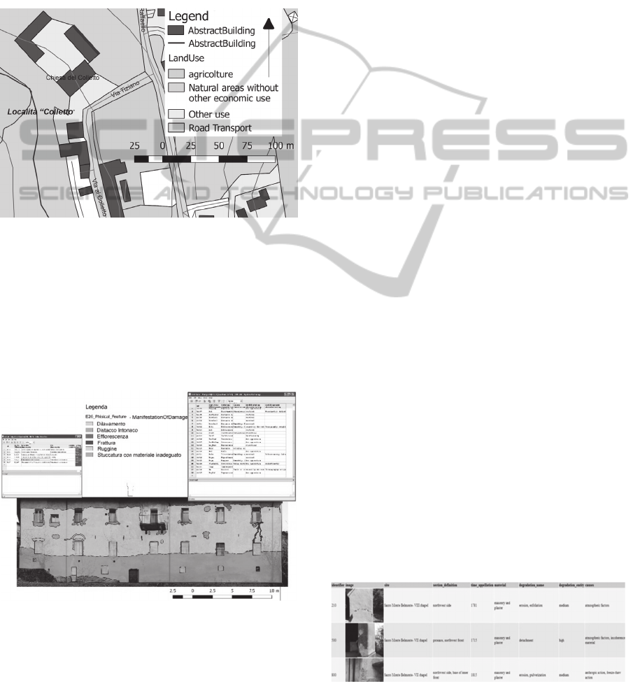
In the example we constructed, a geographically
referenced map represents the building investigated
in its blueprint projection (Fig. 2). Here, the GML
entities “LandUse” and “AbstractBuilding” are
stored; they are useful for embedding the building
studied in its territorial context.
For choosing the values of some classification
attributes we always prefer affirmed taxonomies. For
example, in this case, the values of “LandUse” have
been chosen according to the HILUCS classification
(Hierarchical INSPIRE Land Use Classification
System) given by the INSPIRE European Directive
(inspire.ec.europa.eu/codelist/HILUCSValue/).
On this map, a line (in red in the figure)
distinguishes the projection of one façade (part of
the same entity, “Abstract Building”). This line can
be directly queried and, through a clearly defined
action, another QGIS interface visualising the façade
map can be opened.
This could be done with multiple views of
internal rooms or external façades, so that the
surfaces of an architectural object could be mapped
on the whole object using different reference
systems; these would treat each surface as an
independent plane while obtaining all the similar
data stored in the same central table and making the
ArchitecturalHeritageSemanticDataManagingandSharinginGIS
125
entire structure searchable. For example, it is
possible to have statistics about the whole area (on
all the surfaces of the building) that requires some
kind of preservation intervention, in order to
compute the overall cost of necessary preservation
actions. These structures remain completely
interoperable with the PostgreSQL system at all
times. This interoperability could allow for queries
on objects viewed in both the interfaces at the same
time.
Figure 2: GIS layout representing the object studied (the
ex-convent building annexed to the “Chiesa del Colletto”)
in its context. From this regional map, it is possible to link
to another window where another view at a major scale is
represented (the projection is the red line).
In the example presented, the second QGIS project
shows a façade (the one whose planar projection is the
red line in Fig. 2), on which “Materials” and
“Manifestation Of Damage” (Fig. 3) have been mapped.
Figure 3: Management and representation in GIS of the
“ManifestationOfDamage” values, mapped on the façade
analysed, and the related table in PgAdminIII.
These values are connected to the respective
tables, in which characteristics and other useful
information are also stored. When possible,
taxonomy values are used; they are preferably
acquired from the NORMAL documents, though in
cases of unavailability we used other affirmed
bibliographic sources (Carbonara, 2004). The
schemas defined can be extracted in an
exchangeable format, and can be transposed to other
similar projects and reused. The same can be done
with the data contained in some significant tables,
like the ones containing data extracted from
standards, a specialized bibliography could be
generated, which could be simply updated by adding
information regarding new research and definitions.
2.2 Retrieval of Data Images
This way of managing projects with the use of QGIS
connected to PostgreSQL leads to new opportunities
in CH documentation strategies. This tool allows for
the recording and management of many type of data,
including images. The images, stored and managed
in PostgreSQL, are visualized by means of the
database connection to QGIS. In this way, the
images and their attributes describing the state of
conservation of building elements as well as heritage
management activities can be queried.
The image visualization may be also realized
through loading the PostgreSQL database on a web
page, starting from a php script connection (Fig. 4).
This connection with the Web could be further
exploited in future work for effectively publishing
and sharing data.
The primary goal of data retrieval here is storing,
sharing and updating information about sites and
buildings. A georeferenced repository is structured
in archives able to manage heterogeneous data: the
spatial archive, the images archive and the archive
capturing the CH conservation state. These retrievals
are queried singularly or by means of an integrated
process, according to the aims of the analysis;
through the images and attributes, they offer a highly
detailed reading of geometric and thematic
information in the GIS environment (Fig. 5). Since
PostgreSQL is an ORDBMS, the management of
dynamic data tables- for example, tables concerning
parameters affecting the conservation state - is also
straightforward.
Figure 4: The web page connected to PostgreSQL to
visualize the photo inventory.
GISTAM2015-1stInternationalConferenceonGeographicalInformationSystemsTheory,ApplicationsandManagement
126
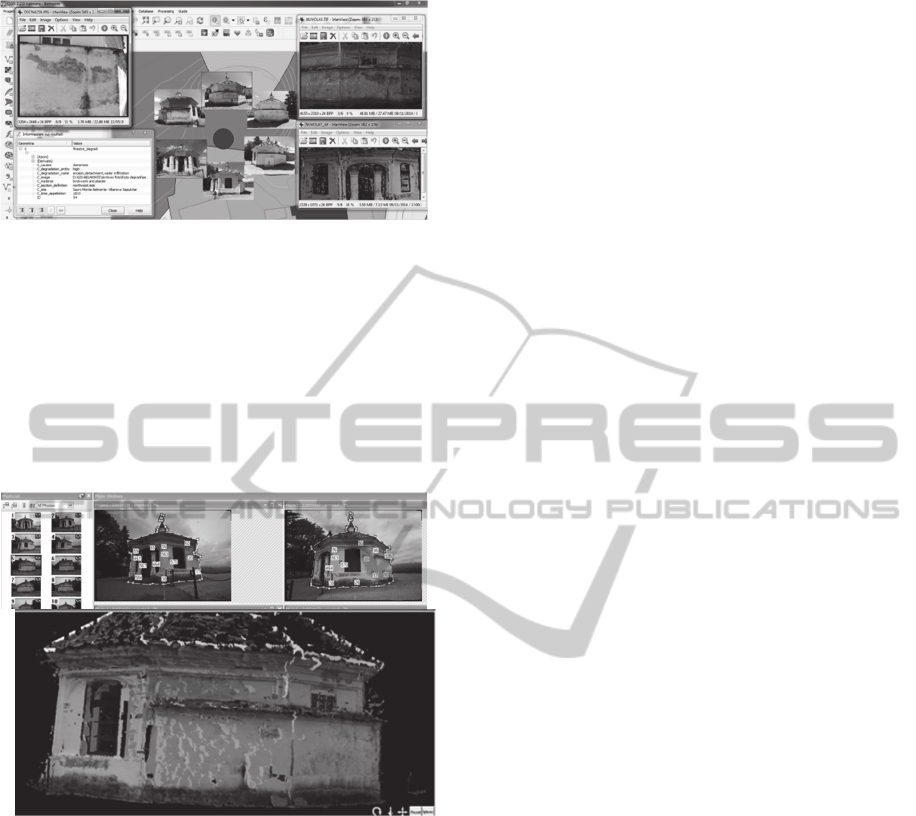
Figure 5: Analysis of materials’ degradation starting from
images, and 3D-metric model in the Belmonte Sacro
Monte (UNESCO Heritage) building.
The georeferenced images repository collects
different images, including the ones acquired to
generate dense 3D models with low cost techniques
(such as image matching and Structure-from-Motion,
Chiabrando et al., 2014). It is possible to query the
images of the object acquired by the camera or
images of the processed 3D model (Fig. 6).
Figure 6: A phase of image matching technique generating
a point cloud model.
The results are different information levels
organized according to a multi-scale approach (from
a territorial to an architectural scale), with the
display of the building surface pathologies directly
on the images and on the 3D-metric model. These
can eventually be mapped using a similar approach
to that described in the previous example.
3 DISCUSSION AND
PERSPECTIVES
The management of Architectural Heritage
documentation by means of some interoperability
tools, such as standards and open-source software,
has been tested experimentally in the examples
presented above.
In this work, some structures enabling the use of
CH semantic information (such as ontologies and
formal languages) have been used together with
tools that the interoperability of data (such as open-
source software). The system could be enhanced
through the use of object-oriented DBMS, which
could catalyse implementation on ontological
models. In any case the management of
heterogeneous and multifaceted data has been shown
to be possible. Moreover, an actual multi-scale
approach has been tested, and the data in the system
can be queried on different levels of interpretation
an essential capability in the CH framework.
The entire workflow has some limits due to the
absence of official integrated standard data models;
in particular, there is a lack of standards in the
acquisition and plotting phases of historical
architectural heritage documentation. This relates to
the fault of homogeneous geometric data, and it is
resultantly more difficult to translate these data into
a unique, integrated and harmonized system.
BIM are recognized as systems suitable for the
3D modelling of historical buildings, and they
provide high editing functionalities for managing the
object representation comprehensively. On the other
hand, GIS fit other CH needs by enabling the
management of more complex and irregular surfaces
in a 2,5D approach. It is therefore possible to realize
analysis and mapping surfaces with semantic
thematic information.
Future work will address the enhancement of these
systems through the improvement of the mutual
integration of models and software implementation.
One of the final aims of both systems is the sharing of
structured data on the Web, so investigation into the
development and implementation of a BIM extension
(GeoBIM) on CityGML is needed. (De Laat and Van
Berlo, 2011).
REFERENCES
Scholl, M., Voisard, A., 1992. Object-oriented database
systems for geographic applications: an experiment
with O2. In: Proc. Int. Workshop on Database
Management Systems for Geographical Applications,
Springer.
Gaede, V., Riekert, W.F., 1994. Spatial access methods
and query processing in the object-oriented GIS
GODOT. In: Proceedings of the AGDM’94 Workshop.
Djindjian F., 1998, GIS usage in world-wide archaeology,
in Archeologia e Calcolatori, 9, pp.19-30.
Taboroff, J., 2000. Cultural heritage and natural disasters:
ArchitecturalHeritageSemanticDataManagingandSharinginGIS
127

incentives for risk management and mitigation. In:
Managing Disaster Risk in Emerging Economies.
World Bank. Disaster Management Risk, 2, pp. 71-79.
Fonseca, F., Egenhofer, M., Davis, C., Camara, G., 2002.
Semantic granularity. In: Ontology-driven geographic
information systems. AMAI Annals of Mathematics
and Artificial Intelligence 36 (1-2), pp. 121-151.
Mennis J.L., 2003. Derivation and implementation of a
semantic GIS data model informed by principles of
cognition. In: Computers, Environment and Urban
Systems 27, pp. 455-479.
Carbonara, G., Atlante del Restauro, UTET, 2004.
Wüst, T., Nebiker, S., Landolt, R., 2004. Applying the 3D
GIS DILAS to Archaeology and Cultural Heritage
Projects Requirements and First Results. In: ISPRS
Archive, 35(Part 5), pp.407-412.
Worboys, M.F., Duckham M., 2004. GIS: a computing
perspective. CRC press.
Guizzardi, G., 2005. Ontological foundations for
structural conceptual models. CTIT, Centre for
Telematics and Information Technology.
NorMaL, Norma tecnica UNI 11182: 2006. Beni Culturali.
Materiali lapidei naturali ed artificiali. Descrizione
della forma di alterazione.–Termini e definizioni.
Doerr, M., Ore, Ch.E., Stead, S., 2007. In: The CIDOC
Conceptual Reference Model - A New Standard for
Knowledge Sharing. Tutorials, posters, panels and
industrial contributions at the 26th International
Conference on Conceptual Modeling - ACS, 83, 51-
56.
Petrescu, F., 2007. The use of GIS technology in cultural
heritage. In Proceedings of the XXI International
CIPA Symposium, Athens, Greece, pp. 01-06.
Meyer, É., Grussenmeyer, P., Perrin, J. P., Durand, A., &
Drap, P., 2007. A web information system for the
management and the dissemination of Cultural
Heritage data. Journal of Cultural Heritage, 8(4), pp.
396-411.
Guarino, N., Oberle, D., Staab, S., 2009. What is an
Ontology? In Handbook on ontologies, Springer
Berlin Heidelberg, pp. 1-17.
De Laat, R., Van Berlo, L., 2011 Integration of BIM and
GIS: The Development of the CityGML GeoBIM
Extension, Advances in 3D Geo-Information Sciences.
LNG&C, pp. 211-225.
Blaško, M., Cacciotti, R., Křemen, P., & Kouba, Z. 2012.
Monument damage ontology. In Progress in CulturaL
Heritage Preservation. Springer B.H., pp. 221-230.
Costamagna, E., Spanò, A., 2012. Semantic models for
Architectural Heritage documentation. In: Lecture
Notes in Computer Science, Springer, pp. 241-250.
Apollonio F, Gaiani M, Benedetti B., 2012, 3D reality-
based artefact models for the management of
archaeological sites using 3D Gis: a framework
starting from the case study of the Pompeii
Archaeological area,
Journal of Archaeological
Science, 39, pp. 1271-1287.
Cacciotti, R., Valach, J., Kuneš, P., Čerňanský, M., Blaško,
M., Křemen, P., 2013. Monument Damage Information
System (Mondis): an ontological approach to Cultural
Heritage documentation. In:ISPRS Annals, II-5/W1.
Le Boeuf, P., Doerr, M., Ore, C.E., Stead, S., 2013.
Definition of the CIDOC-CRM. Produced by the
ICOM/CIDOC Documentation Standards Group
Continued by the CIDOC CRM Special Interest
Group. Version 5.1.2. pp. 12-13.
Myers D., Avramides Y., Dalgity A., 2013. Changing the
Heritage inventory paradigm, The ARCHES Open
Source System, in Conservation Perspectives, The
GCI newsletter, vol. 28, n.2.
Spanò, A., Cerutti, E., Bartolozzi, C., Novelli, F., 2014. Worthy
Outcomes from a System Advancing the Sharing of CH
Data and Stakeholders’ Relations. In: EuroMed 2014,
LNCS 8740, Springer I.P.S. pp. 606–616.
Chiabrando, F, Lingua, A, Noardo, F, Spanò A, 2014. 3D
modelling of trompe l'oeil decorated vaults using
dense matching techniques. In: ISPRS Annals, II-5, pp.
97-104.
Rodríguez Miranda, Á., Valle Melón, J. M., Porcal
Gonzalo, M. C., 2014. Design of tailored strategies for
preservation and re-use of information about heritage.
In: Euromed 2014 Proceedings ISBN:978 1 907132
47 6.
inspire.ec.europa.eu/codelist/HILUCSValue/ Accessed on
02/12/2014.
http://www.daml.org/2001/03/daml+oil-index.html
Accessed on 01/12/2014.
World Wide Web Consortium (W3C), OWL Web
Ontology Language Guide, 2004.
http://www.w3.org/TR/2004/REC-owl-guide-200402
10/ Accessed on 30/11/2014.
http://www.opengeospatial.org/standards/citygmlAccessed
on 03/12/2014.
http://www.opengeospatial.org/standards/geosparqlAccess
ed on 03/12/2014.
http://www.w3.org/2001/sw/wiki/OWL Accessed on
03/12/2014.
www.w3.org/RDF/ Accessed on 03/12/2014.
GISTAM2015-1stInternationalConferenceonGeographicalInformationSystemsTheory,ApplicationsandManagement
128
