
A 4D Virtual/Augmented Reality Viewer Exploiting Unstructured
Web-based Image Data
Anastasios Doulamis
1
, Nikolaos Doulamis
1
, Konstantinos Makantasis
2
and Michael Klein
3
1
Computer Vision Photogrammetry Lab.., Technical University of Athens, 9th Heroon Polytechniou str., Athens, Greece
2
Department of Production and Survey Engineering, Technical University of Crete, Polytechnioupolis, Crete, Greece
3
7 Reasons Company, ltd, 4-6th Bäuerlegasse, Vienna, Austria
Keywords: 4D Modelling, 3D Reconstruction, Content-based Filtering, Web-based Images, Virtual/Augmented Reality.
Abstract: Outdoor large-scale cultural sites are mostly sensitive to environmental, natural and human made factors,
implying an imminent need for a spatio-temporal assessment to identify regions of potential cultural interest
(material degradation, structuring, conservation). Thus, 4D modelling (3D plus the time) is ideally required
for preservation and assessment of outdoor large scale cultural sites, which is currently implemented as a
simple aggregation of 3D digital models at different time. However, it is difficult to implement temporal 3D
modelling for many time instances using conventional capturing tools since we need high financial effort
and computational complexity in acquiring a set of the most suitable image data. One way to address this, is
to exploit the huge amount of images distributing over visual hosting repositories, such as flickr and picasa.
These visual data, nevertheless, are loosely structured and thus no appropriate for 3D modelling. For this
reason, a new content-based filtering mechanism should be implemented so as to rank (filter) images
according to their contribution to the 3D reconstruction process and discards image outliers that can either
confuse or delay the 3D reconstruction process. Then, we proceed to the implementation of a
virtual/augmented reality which allows the cultural heritage actors to temporally assess cultural objects of
interest and assists conservators to check how restoration methods affect an object or how materials decay
through time. The proposed system has been developed and evaluated using real-life data and outdoor sites.
1 INTRODUCTION
Digitalizing cultural sites and objects and creating
3D digital models is an important task to preserve
Cultural Heritage (CH). Among all CH resources,
the outdoor large-scale cultural sites are mostly
sensitive to weather conditions, natural phenomena
(earthquakes, flooding, etc), excavation procedures,
and restoration protocols. This implies an imminent
need for a spatio-temporal monitoring of those sites
to identify regions of potential material degradation,
and unstable structuring conditions. Thus, a time
varying 3D model (i.e., 4D modelling-3D geometric
dimensions plus the time) should be developed to
assess spatial and temporal diversity of CH objects
but again under a cost-effective framework able to
be applied to large-scale sites.
One main difficulty of implementing temporal
3D modelling is the complexity, and the respective
financial effort, in acquiring a set of images required
for the 3D reconstruction. One way to address this,
is to exploit the huge amount of images distributing
over visual hosting repositories, such as flickr and
picasa (Doulamis et al, 2013). However, the main
functionality of the existing web-based visual
repositories is to socially share multimedia content,
instead of archiving the images in a way that allows
efficient and precise 3D modelling of objects of
interest. This unstructured organization of images,
with respect to 3D reconstruction, imposes new tools
and methods in the area of content based filtering;
ranking (filtering) images according to their
contribution to the 3D reconstruction process while
at the same time discarding image outliers that can
either confuse or delay the 3D reconstruction
process
Content Based Image Retrieval (CBIR) methods
can be considered as the first approaches for
organizing multimedia content (Murthy et. al.,
2010). The main goal of a CBIR method is to find a
set of images whose contents are similar to, or even
match with, a given query from within a large image
631
Doulamis A., Doulamis N., Makantasis K. and Klein M..
A 4D Virtual/Augmented Reality Viewer Exploiting Unstructured Web-based Image Data.
DOI: 10.5220/0005456806310639
In Proceedings of the 10th International Conference on Computer Vision Theory and Applications (MMS-ER3D-2015), pages 631-639
ISBN: 978-989-758-090-1
Copyright
c
2015 SCITEPRESS (Science and Technology Publications, Lda.)

database. According to (Daras et. al., 2012) the
combination of multiple 3-D object descriptors can
achieve better retrieval accuracy than a single
descriptor vector alone. Thus, research should focus
not only on the investigation of the optimal
descriptor but also on the appropriate combination of
low-level descriptors as well as on the selection of
the best features and matching metrics. In particular,
in the SHREC'11 search and retrieval competition,
the best performance is achieved by combining a)
the Spectral Decomposition of the Geodesic
Distance Matrix and b) the Scale Invariant Feature
Transform for meshes (meshSIFT) (Smeets et. al.,
2009).
Towards this direction, (Murthy et. al., 2010)
introduces a two layer image retrieval algorithm that
exploits hierarchical clustering based on colour
features. In the same context, the retrieval system of
(Chum et. al., 2007) returns all different views of an
object upon a user's query. However, the main
limitation of these works is that they require a query
image to carry out the retrieval process which is not
suitable in our case; better organization of images
with respect to 3D reconstruction.
Unsupervised content based organization has
been introduced in (Kekre et al., 2010) to create
codebooks based on colour descriptors. Another
approach exploits fuzzy Support Vectors Machines
(fSVMs) to cluster visual information while visual
encoding is carried out on the use of dominant
colour descriptor (Min and Cheng, 2009). The main
limitations of these approaches rely on the usage of
global image features to encode visual content.
Therefore, they are not suitable for an efficient
content-based organization towards 3D
reconstruction due to the fact that global descriptors
fail to represent the different view instances of an
object since they are not able to capture geometric
characteristics.
Some other techniques filter out the retrievals
using textual and/or geo-location information. The
tools combine geo-information along with a
hierarchical clustering method that exploits visual
features to obtain dense groups (Arampatzis et. al,
2013) and (Papadopoulos et. al., 2010). Again, these
methods are based on global descriptors, failing to
represent image geometry.
A content-based filtering method suitable for
organizing visual content located over distributed
web-based image repositories for the purposes of 3D
reconstruction have been proposed in (Makantasis
et. al., 2014). The algorithm exploits local geometric
properties and density based clustering methods to
organize unstructured multimedia content in a way
to accelerate 3D reconstruction, while keeping its
performance as precise as possible. A semi-
supervised approach is presented in (Protopapadakis
et al, 2014)
While the work of (Makantasis et. al., 2014)
introduces a method for efficiently ranking images
according to their contribution to the 3D
reconstruction process, it fails to incorporate the
results into a virtual and augmented reality interface.
The latter not only exploits the organization of the
images in order to achieve 3D modelling but also
permits the users to spatio-temporally assess the
derived 3D models (Hadjiprocopis et. al, 2014).
Only under such a framework, the content based
organization methods of (Makantasis et. al., 2014)
can be exploited in real-life conditions. The
developed scheme assists conservators to check how
restoration methods affect an object or how
materials decay through time, archaeologists to
better document an item, curators to properly display
them, and the creative industries to disseminate
cultural knowledge in a digestive way worldwide.
Today, the construction of high fidelity 3D models is
a time consuming task, with limited functionalities
since it cannot capture time evolutions properties of
an item (how it behaves in time) and scalable
functionalities needed for different types of CH
actors. In addition, the time required to get a precise
model is often too high due to the manual effort
needed to be interwoven in the reconstruction
process. For this reason, 3D digitalization is mainly
applied to individualized items of museums'
collections, to indoor cultural assets where temporal
variations is minimal and to famous sites/museums
where adequate financial resources can be given to
perform such a digitalization.
This paper is organized as follows. In Section 2,
we discuss the algorithms used for modelling the
retrieved images under a geometrically invariant
framework. In this section, we also discuss the
methods for transforming the image data into
multidimensional key-points onto a manifold in a
way that the distance between two points coincide
with the visual similarity distance between the two
images. Then, Section 3 presents the content based
filtering algorithms used for structuring the retrieved
data from distributed Web repositories for 3D
reconstruction purposes. This section includes the
algorithm used for removing the image outliers as
well as the methods used for extracting the most
appropriate images for 3D reconstruction. Section 4
discuss the 4D CH viewer as well the respective
augmented reality functionalities that allow for the
end-users to overlay, track and manipulate 3D
VISAPP2015-InternationalConferenceonComputerVisionTheoryandApplications
632

reconstructed objects over 2D interfaces. Finally,
Section 5 presents the experimental results along
with 4D cultural heritage viewer representation,
while Section 6 concludes the paper.
2 CONTENT MODELLING
2.1 Geometrically Invariant Modelling
Initially, the ORB (Oriented FAST and Rotated
BRIEF) is used for locally representing the visual
properties of an image (Rublee et. al., 2011). ORB
extracts a set of image keypoints which are then
used to describe geometric characteristics of an
image under an invariant affine transformation way.
Selection of ORB compare to other local descriptors,
like SURF, SIFT, is that it gives the same
performance as SIFT while being two orders of
magnitude faster.
Then, the visual similarity between two images is
computed. Visual similarity is measured over the
correspondence points of the two images. The
correspondence points are estimated by applying a
nearest neighbour matching algorithm on the
extracted key-points. In this paper, the local
sensitive hashing approach and the hamming
distance are adopted (Lv et. al., 2007) as far as the
matching algorithm is concerned since the extracted
key-points of ORB are described as a binary pattern.
Let us denote as
)( A
i
k
and
)(B
j
i
k
two correspondent
key points between two images A and B. Then, we
form a set
)( BA
M
that contains the correspondent
key-points from the image A to B and a set
)( AB
M
that contains the respective points from B. The
intersection between those two sets defines the 2-
way matching. Then Then, that the similarity
between images A and B can be defined as
KMs
BA
BjAi
/
),(
,
(1)
where
),( BA
M
refers to the cardinality of
),( BA
M
set and K the number of extracted key-points.
Using the aforementioned process for all N
retrieved images, we conclude to an NxN symmetric
matrix S whose elements
T
ji
s ]10[
,
. Values close
to zero indicate no relation between the two images,
while values near one a high relationship degree.
The visual dissimilarity matrix D is defined as the
logarithm of S,
)log(][
,
SD
ji
d
.
2.2 Multi-dimensional Manifolds
By exploiting the similarity matrix D, we can
represent the N retrieved images as single points
onto a multidimensional manifold. In particular, let
us define as
R
i
)(
x
the coordinates of the i-th
image onto the μ-dimensional space. Then, using the
multi-dimensional scaling method (cMDS) [see
(Cox and Cox, 2000)], we relate the coordinates of
the μ-dimensional image points with the similarity
distance matrix D.
In particular, images that are visually similar
would be mapped onto points of the
multidimensional manifold, which are located
"closely enough" in the subspace. On the contrary,
image outliers will be spread far away. The multi-
dimensional manifold is constructed in a way so that
the distance between two image points of the μ-
dimensional space coincides with the respective
similarity distance
)log(
,, jiji
sd
or
jid
ji
ji
,
,
)()(
xx
.
In the sequel, we exploit the concepts of cMDS
(Cox and Cox, 2000) to establish a connection
between the space of the distances and the space of
Gram matrix
T
XXB
(Cayton, 2006). X is the
matrix that contains all N image coordinates
)(i
x .
More specifically, matrix D is an Euclidean
distance matrix if and only if
HDHB
*2/1
,
where
T
N 11IH */1
a positive semi-definite
matrix with I the unity one and 1 a vector of all
ones elements. Furthermore, this B will be the Gram
matrix for a mean centred configuration with
interpoint distances given by D. Assuming non
Euclidean spaces, matrix B as described above will
not be positive semi-definite, and thus it will not be
a Gram matrix. To handle such cases, cMDS
projects the Gram matrix B onto the cone of positive
semi-definite matrices by setting its negative
eigenvalues to zero.
Having estimated the Gram matrix B, we are
able to get matrix X by spectrally decomposing B
into
T
UVU
and then
2/1
VUX
. Let us now
denote as
i
q i=1,2,…Ν the eigenvectors of B and as
i
the respective eigenvalues. Then matrix U is the
square NxN matrix whose i-th column is the
eigenvector q
i
of B and V is the diagonal matrix
whose diagonal elements are the corresponding
eigenvalues. Finally the dimension μ of the
multidimensional space is equal to the multiplicity
of non-zero eigenvalues of matrix B.
A4DVirtual/AugmentedRealityViewerExploitingUnstructuredWeb-basedImageData
633

3 SELECTION OF THE MOST
REPRESENTATIVE IMAGES
FOR 3D RECONSTRUCTION
In this section, we describe the tools applied to (i)
remove image outliers and (ii) select a set of
representative images enabling an as much as
possible precise 3D reconstruction.
3.1 Outliers Removal
Since in our system 3D reconstruction takes place
from a set of loosely structured imagery data located
over distributed web-based repositories, we expect
that several images that fit a specific category will
be in fact outliers. A density-based visual clustering
algorithm is adopted in this paper to remove the
outliers. As we have no prior knowledge regarding
outliers density parameters (e.g., the area of the
outliers' region and how dense it is), we apply a
procedure to automatically estimate them as in
(Makantasis et. al, 2014).
Then, a modified version of the DBSCAN,
density based clustering algorithm, named Core
Sample Partitioning (CSP), is selected to remove the
outliers. The conventional version of DBSCAN
creates a compact subset by including all points of
the multi-dimensional manifold that are either
density reachable or density connected to a core
sample. Two points are density reachable if they are
either direct reachable, that is, they belong to the
same density area with respect to a similarity
distance, or there exists a chain of points that some
of them are directly reachable.
The main drawback of the conventional
DBSCAN algorithm in the context of our paper is
that, although it minimizes the probability of
excluding relevant images, it also includes some of
the outliers in the target subspace. On the contrary,
CSP exploits the notion of directly density-
reachability, creating a set that minimizes the
probability of an image outlier to belong to the
partitioned subset of relevant images. If we suppose
that a large enough set of images for an object is
available, the proposed modified DBSCAN
approach selects images for the 3D reconstruction
process that yield low computational complexity,
while its precision performance remains almost the
same.
3.2 Representative Images for 3D
Reconstruction
The modified CSP algorithm discards image outliers
since it detects sparse image samples spreading far
away from the dense subspace of the “relevant
images” onto the multi-dimensional manifold. This
way, we exclude the visual space into two areas; the
one of the outliers and the one of the relevant
images. Having detected the relevant set, we need
then to proceed to the extraction of a small set of
representative images of the object of interest that
can maximize geometric depiction. This is achieved
in this paper using a spectral clustering method. The
advantages of the spectral clustering algorithm is
that it treats clustering as a graph partitioning
problem without making specific assumptions on the
form of the created clusters (Bach and Jordan,
2003).
Spectral clustering optimally solves a graph
partitioning problem so that (i) elements within a
cluster present the maximum coherence, while (ii)
elements across data presents the minimum
coherence. This is achieved by estimating the
similarity degree among the partition vertices. That
is, this similarity across vertices belonging to the
same cluster is expected to increase while, on the
contrary, the similarity among the vertices of
different partitions is expected to decrease. To avoid
convergence of the algorithm to trivial solutions in
which a cluster consists only of one element,
normalization factors are imposed in the
minimization process.
Since a graph can be straightforward represented
in a matrix representation, we can formulate the
aforementioned twofold minimization process in a
matrix form as
M
r
r
T
r
r
T
r
r
1
)(
min:
ˆ
aLa
aLa
a
E
(2)
where
Tu
rr
a ][ a
is an index vector, whose the
u-th entry equals to unity whether the respective u-th
image is assigned to the r-th partition
r
C , and zero
otherwise.
We also denote as E the adjacent matrix of the
graph G. Therefore, we have that matrix E is
expressed as
][
ij
w
E
where the elements of
ij
w
are
modelled as
)log(
ijijij
sdw
. We recall that
,ij
s
is the similarity matching between the images i
and j respectively.
Let us also denote as Z the degree matrix of the
graph G as a diagonal matrix )(
i
zdiagZ with
VISAPP2015-InternationalConferenceonComputerVisionTheoryandApplications
634

Cj
iji
wz
. Then, we can define the Laplacian
matrix of the graph G as L=Z-E.
In order to solve the aforementioned
optimization problem, we need to relax the index
vector of
Tu
rr
a ][ a
to take continuous values
instead of binary ones. This means that we assume
that each image is possible to be assigned to all
potential clusters but of different degree of
membership. The relaxed continuous solution of
Tu
rr
a ][ a
is obtained by exploiting the Ky-Fan
theorem (Fan, 1951). Then, a rounding process is
adopted to discretize the continuous solution into a
binary one.
The approach adopted in this paper treats the
rows of the continuous matrix as M-dimensional
feature vectors. Each row indicates the degree of
“fitness” (the association degree) of the
corresponding image to each of the M available
clusters. It has been shown in (Bach and Jordan,
2003) that the aforementioned approximation
provides the minimum Frobenius distance between
the continuous and the discrete solution. Thus, this is
the closest approximate solution to the continuous
optimum provided by the Ky-Fan theorem. The
well-known k-means algorithm is applied to
optimally estimate the most suitable clusters. The
number of clusters is set equal to the parameter M.
We recall that M is the number of estimated
partitions of graph G. When we increase the value of
variable M, we lead to the selection of a greater
number of images used for 3D reconstruction and
thus for a more precise performance. This increment,
however, also yields to an increase of the
computational complexity as well. The estimation of
an appropriate value for parameter M takes place in
regard to application scenarios. Different scenarios
suggest different constraints in regard to devices’
computational power and available memory as well
as the desired re-construction time.
Then, we extract per each cluster the image point
located closer to the its centre as the most
representative one.
4 VIRTUAL AND AUGMENTED
REALITY INTERFACE
Virtual Reality (VR) is a computer simulation of a
real or imaginary system that enables a user to
perform operations on the simulated module and
shows the effects in real time. Real-time interactive
applications, which respond immediately to user
input, allow the user to fly and walk through various
scenes and inspect different objects of interest in the
reconstructed scene. Augmented Reality (AR) is
understood as an implementation of the virtual
reality into the real world. Therefore it is also known
as “mixed reality”. This method is enhanced with
additional 3D graphics superimposed on user's field
of view usually through the use of a portable media
device. Furthermore AR also brings about an
interactive experience, but aims to supplement the
real world, rather than creating an entirely artificial
environment.
The implementation of the proposed content-
based filtering method into a virtual reality
framework would be very useful for cultural heritage
actors. It allows for easy distribution and publishing
of the content from everywhere and for everybody.
Virtual and augmented reality tools enrich the
current digital counterparts to be straightforward
applicable for using under different circumstances
such as remotely and virtually navigating an
archaeological site (déjà-vu), retrieve similar CH
objects in terms of conservation methods used, style,
operational used, evaluate the effect of different
capturing technologies, promote mixing of tangible
with the intangible content (humans’ behaviours on
items functional use), etc.
The visualization of the 3D objects plus the time
is an essential part, as it is what the user perceives.
In order to appreciate the richness of these 4D
objects, we need a performant multipurpose VR
viewer. The VR viewer is an integration of two
levels of sub-viewers corresponding to the
dimensions: the 3D sub-viewer and the 4D sub-
viewer. The 3D VR sub-viewer ensures a true 3D
visualization of the static objects. For the 4D viewer,
the 4th dimension is the time and its visualization is
typically based on animation. The problem is how to
balance the time used to render the scene and how
much is stored in memory in form of pre-computed
animations.
The implementation into the real world is based
on various initiation processes. The first one is
image recognition which allows the user to project
virtual objects into the real environment based on
the position of the image target. As the name
implies, image targets are images that can be
detected and tracked. Unlike traditional markers,
data matrix codes and QR codes, image targets do
not need special black and white regions or codes to
be recognized. There are sophisticated algorithms to
detect and track the features that are naturally found
in the image itself. The system recognizes the image
target by comparing these natural features against a
A4DVirtual/AugmentedRealityViewerExploitingUnstructuredWeb-basedImageData
635
known target resource database. Once the image
target is detected, it tracks the image as long as it is
at least partially in the camera’s field of view.
Feasible targets can be photos, game boards,
magazine pages, book covers, product packaging,
posters, greeting cards as well as architectural
environments. In our case, photos were used for
image tracking.
Once an image is tracked, there is also a
possibility of extended tracking, where the target
remains visible, even if the tracker is out of sight.
This provides more stability for the augmented
object, keeping it in sight even if only partial tracker
recognition is given.
The second tracking method is the positioning of
the objects based on GPS information which
currently has an accuracy of 10 meters. This is a
more inaccurate solution and limits the viewing of
the object to a predefined site.
For a more sophisticated handling of the objects
augmented reality can be combined with 3D real
time game engines, resulting in an interactive
augmented reality system. This way, human senses
are more involved and the immersion into the
presented virtual content is consequently much
greater.
We have implemented all the techniques under
the framework of a European Union project and is
served as an interface to the public, and includes
some of the above mentioned features. Virtual
content can be presented in above described
approaches in different ways. One is referencing the
objects on geographical position presented on
referenced maps of different types (historical,
hydrological, geological, etc.). The other is
enhancement of the already existing media.
The objects can be viewed, interacted or further
information about them can be accessed. The
information can consist of related multi-medial
content like objects, images, texts, links, videos and
audio. A live demonstration is available on the
youtube and on the authors' web site.
5 EXPERIMENTAL RESULTS
The research aims to analyse, design, develop and
validate an innovative system for the rapid and cost-
effective 4D (time varying 3 dimensional space
modelling) model reconstruction from images
selected from the wild (being captured and stored in
image repositories for non-professional 3D
reconstruction use) and support the aim of digital
libraries Europeana and UNESCO Memory of the
World to build a sense of a shard European cultural
history and identity. A 4D dimensional research is
also presented in (Kyriakaki, 2014).
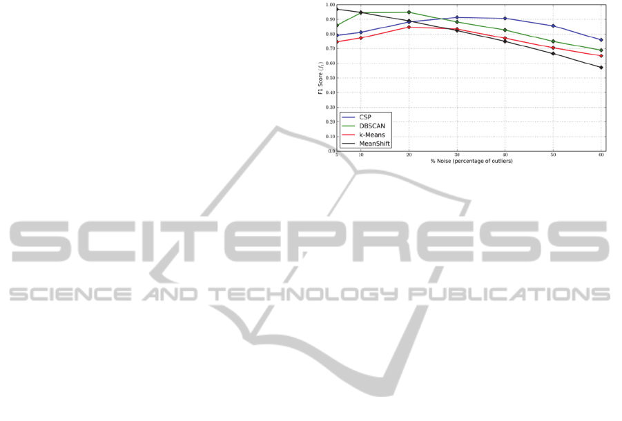
Figure 1: F1 Score versus noise outliers using different
density-based clustering methods.
5.1 Evaluation in Detecting Image
Outliers
Using expert’s assessment, we have initially
annotated a large collection of 31,000 images into
two categories; (i) the one of “relevant image set”
and (ii) the one of image outliers. Fig 1 presents the
F1 Score for two density-based image partitioning
approaches, the conventional DBSCAN and the CSP
method, regarding outliers' removal. For the
evaluation, we range the noise, the percentage of
image outliers, in the created datasets from 5% to
60%. We observe that for a small number of image
outliers (less than 30%) the conventional DBSCAN
algorithm yields better performance. As the noise
increases, however, a common case for our web-
based loosely structured visual content, the
performance of the new CSP density-based
algorithm outperforms the conventional DBSCAN
approach. This is due to the fact that the CSP
partitioning approach is more prone to false
negatives, while DBSCAN is more prone to false
positives.
In the same figure, we have also compared the
results with two other methods, the K-Means and
MeanShift approach. For both cases and for high
values of noise, the adopted CSP method yields
better performance.
5.2 Evaluation in Image Ranking with
Respect to 3D Reconstruction
Initially, an annotation set is created using experts’
assessment. Let us denote as C
n
a set that contains
the n most appropriate images for 3D reconstruction,
i.e., images that correspond to different geometric
views of the object. In the sequel, the spectral based
VISAPP2015-InternationalConferenceonComputerVisionTheoryandApplications
636
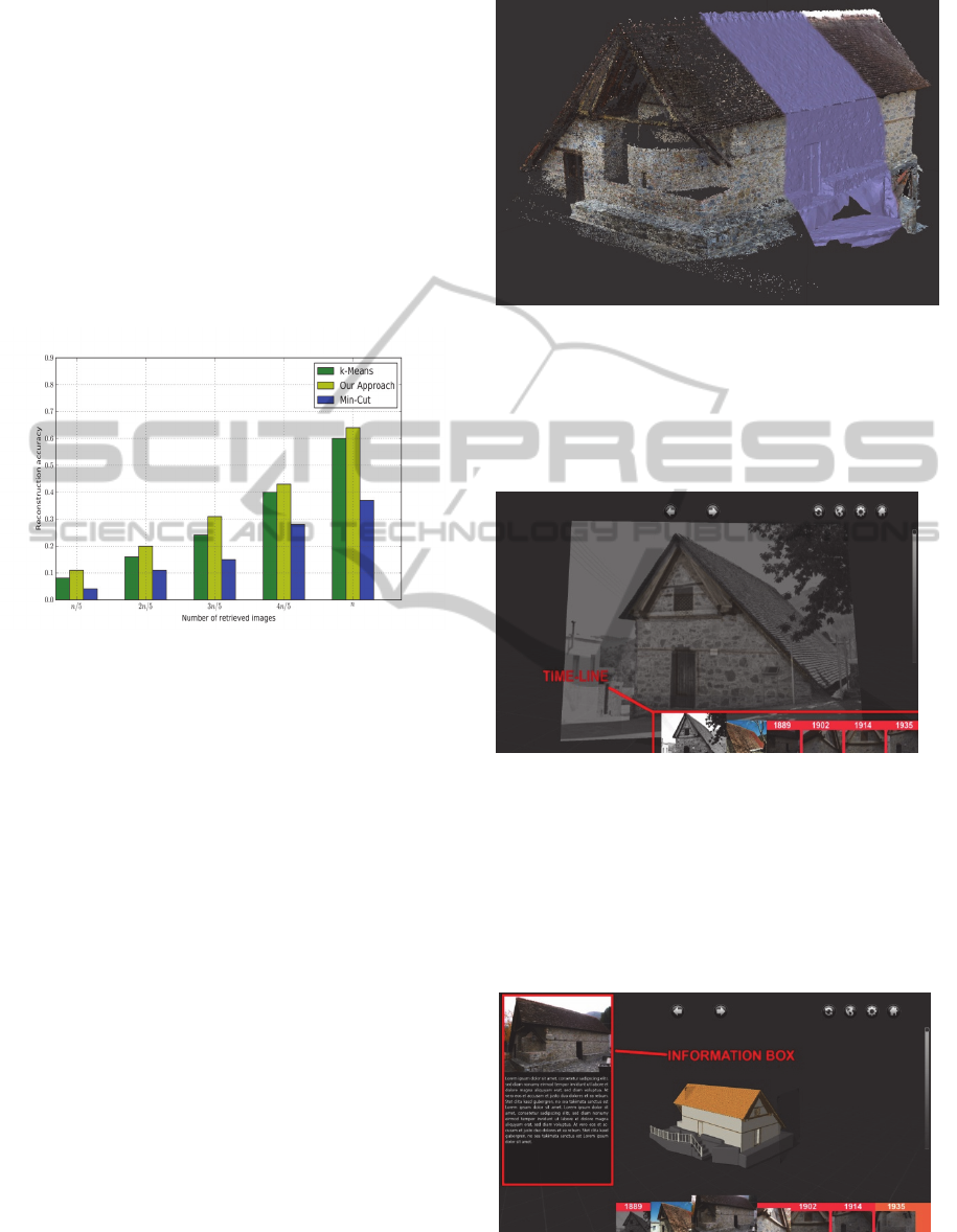
ranked images are extracted by setting graph
partitions to be equal to n/5, 2n/5, 3n/5, 4n/5 and n,
resulting in a maximum reconstruction accuracy of
20%, 40%, 60%, 80% and 100% respectively. Fig. 2
represents the results regarding reconstruction
accuracy with respect to the number of selected
representatives. In the same figure, we have
compared the results two other approaches; the k-
means and the min cut graph partitioning method.
As is observed, our method outperforms both the
two compared ones, in the sense that it extracts
images contributing more to the 3D reconstruction
process.
Figure 2: Reconstruction accuracy in regard to the number
of selected representatives and comparisons with other
methods.
Fig. 3 depicts an example of a 3D reconstruction
from the Archangelos Michael Church. The
reconstruction has been obtained using images. In
this figure, we illustrate from left to right the point
clouds, 3D meshes and the textured 3D mesh.
5.3 Virtual Reality Interface
The Virtual Reality (VR) viewer is an attempt to
create an end-user software which manages the
presentation of the various data-sets (imagery, 3D
scans, 3D models, etc.). In the case study the 3D
model of Archangelos Michael church with different
information levels is presented.
The viewer allows the user to access different
information through various functions. It is designed
with a user friendly interface for an intuitive
working experience. They can be viewed from all
sides, as well as from out- and inside. With the slice-
tool the model can be cut and inspected deeper.
On the bottom of the screen a slider is provided
which allows the user to move through different
time periods accompanied with the images of the
monument in the current period. Sliding over the
Figure 3: 3D reconstruction using the images obtained
from ranking algorithm. The object of interest is the
Archangelos Michael church; left to right: point cloud, 3D
mesh, textured 3D mesh.
images the user can navigate in time and across
different parts of the model (Fig. 4).
Figure 4: The Time-line feature in the VR Viewer.
The system also includes an information box in
which meta-data and in case of additional
reconstructions also para-data of the site together
with its context (period, special morphology,
references, additional images) are presented as well
as links to architectural, historical, artistic, social,
religious or political interest information (Fig. 5).
Figure 5: The Information Box feature in the VR viewer.
The slice tool enables the user to view
A4DVirtual/AugmentedRealityViewerExploitingUnstructuredWeb-basedImageData
637
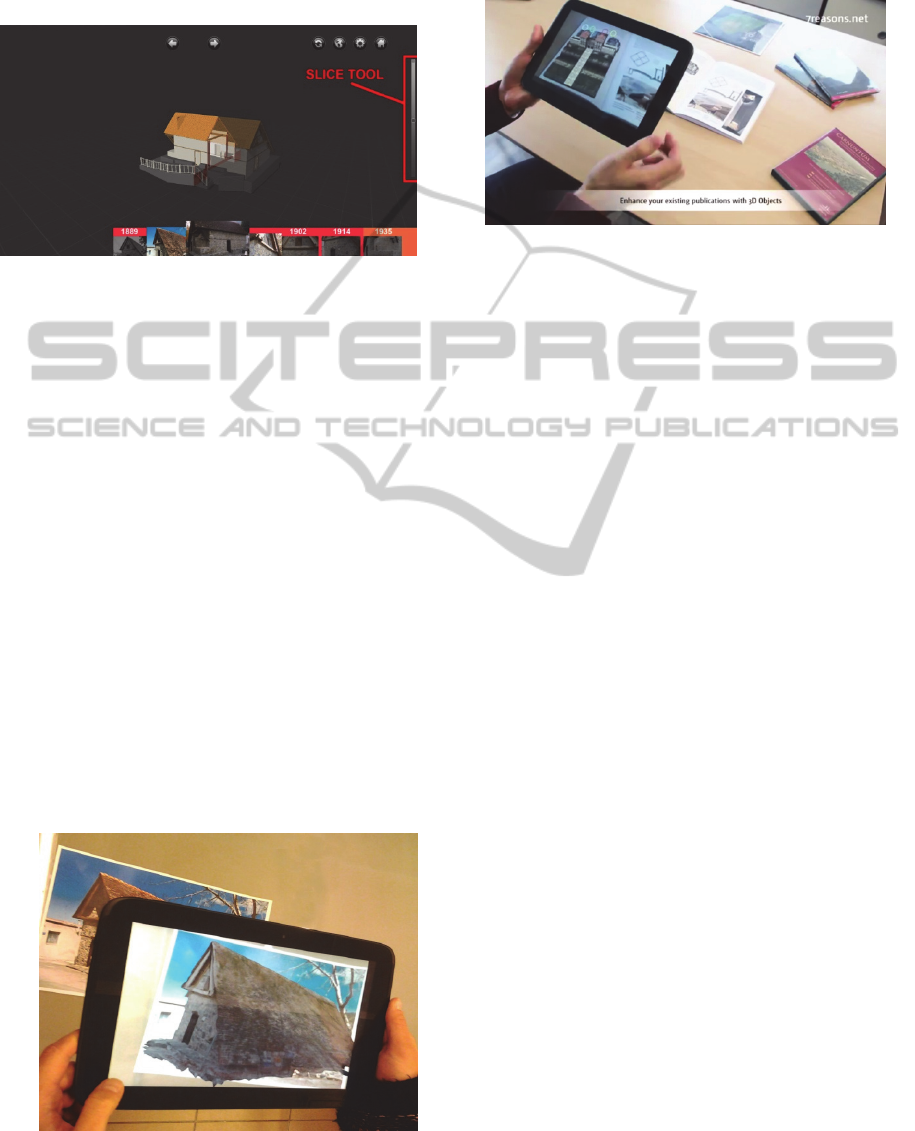
intersection of the reconstructed model with the help
of a slicing plane (Fig. 6). This provides an insight
to the interior construction of the model. With this
tool also the inner image overlays are accessed.
Figure 6: The Slice Tool in the VR Viewer.
In terms of augmented reality models can be for
example placed on a picture. In our test we made a
perspective related integration of the model so the
user can view the 3D model and therefore also the
non-visible parts from the 2D picture (Fig. 15).
The augmented content can be shown on the
original site or on recognized images in various
medias to enrich existing print- (books, articles,
maps, posters) and online-media.
5.4 Augmented Reality Interface
In terms of augmented reality models can be for
example placed on a picture. In our test we made a
perspective related integration of the model so the
user can view the 3D model and therefore also the
non-visible parts from the 2D picture (Figure 7).
The augmented content can be shown on the
original site or on recognized images in various
medias to enrich existing print- (books, articles,
maps, posters) and online-media. Another example
of augmented reality system is shown in Fig. 8. A
Figure 7: Augmented Reality – alignment of the model
over a physical image.
live demonstration of the AR viewer and its
functionalities is available on the youtube and on the
authors' web site.
Figure 8: Another example of Augmented Reality.
6 CONCLUSIONS
In this paper, a new timely evolved 3D
reconstruction process is proposed using as inputs
photos derived from web-based loosely structured
visual repositories, like flickr and picasa. The
method allows a 4D representation of outdoor
cultural sites (3D geometry plus the time). To fulfil
our objectives, initially we apply a content-based
filtering algorithm able to remove outliers that may
confuse the reconstruction process on the use of
density-based clustering. Then, we proceed with the
extraction of a set of representative images that can
described as much as possible the different
geometric views of an object. This is accomplished
using spectral graph partitioning. Finally, a
virtual/augmented reality interface is proposed to
assist cultural heritage actors to evaluate defects,
restoration processes and other phenomena on
cultural objects of interest.
Experimental results on real-life web-based
visual data indicate the outperformance of the
proposed content-based filtering method than other
conventional schemes. The evaluation has been
carried out using objective criteria as of F1 score
and reconstruction accuracy. In addition, the
virtual/augmented reality viewer is demonstrated
against actual cultural sites while its features are also
available on youtube network.
ACKNOWLEDGEMENT
The research leading to these results has been
supported by European Union funds and National
funds (GSRT) from Greece and EU under the
project JASON: Joint synergistic and integrated use
VISAPP2015-InternationalConferenceonComputerVisionTheoryandApplications
638

of "eArth obServation, navigatiOn and
commuNication technologies for enhanced border
security funded under the cooperation framework.
REFERENCES
Arampatzis, A., Zagoris, K., and Chatzichristofis, S. A.,
2013. Dynamic two-stage image retrieval from large
multimedia databases. In. Process. Manag., vol. 49,
no. 1, pp. 274–285.
Bach, F. R., and Jordan, M. I., 2003. Learning Spectral
Clustering. Computer Science Division, University of
California at Berkeley, Berkeley, California.
Cayton, L, 2006. Algorithms for manifold learning.
University of California, San Diego, Tech. Rep.
CS2008-0923.
Chum, O., Philbin, J., Sivic, J., Isard, M., and Zisserman,
A., 2007. Total Recall: Automatic Query Expansion
with a Generative Feature Model for Object Retrieval.
In IEEE 11th International Conference on Computer
Vision, 2007. ICCV 2007, pp. 1–8.
Cox, T., Cox, M., 2000. Multidimensional Scaling.
Chapman & Hall/CRC, Second Edition.
Daras, P., Axenopoulos, A., Litos, G., 2012. Investigating
the Effects of Multiple Factors towards more Accurate
3D Object Retrieval. IEEE Transactions on
Multimedia, Vol. 14, No. 2, Page(s): 374 – 388.
Doulamis, A., Ioannides, M., Doulamis, N.,
Hadjiprocopis, A., Fritsch, D., Balet, O., Julien, M.,
Protopapadakis, E., Makantasis, K., Weinlinger, G.,
S.Johnsons, P., Klein, M., Fellner, D., Stork, A.,
Santos, P. 2013. 4D reconstruction of the past.
Proceedings of SPIE - The International Society for
Optical Engineering, 8795, art. no. 87950.
Fan, K., 1951. Maximum Properties and Inequalities for
the Eigenvalues of Completely Continuous Operators.
Proc. Natl. Acad. Sci. U. S. A., vol. 37, no. 11, pp.
760–766.
Hadjiprocopis, A., Ioannides, M., Wenzel, K., Rothermel,
M., Johnsons, P.S., Fritsch, D., Doulamis, A.,
Protopapadakis, E., Kyriakaki, G., Makantasis, K.,
Weinlinger, G., Klein, M., Fellner, D., Stork, A.,
Santos, P. 4D reconstruction of the past: The image
retrieval and 3D model construction pipeline. 2014
(2014) Proceedings of SPIE - The International
Society for Optical Engineering, 9229, art. no.
922916, .
Kekre, D. H. B., Sarode, T. K., Thepade S. D., and
Vaishali V., 2010. Improved texture feature based
image retrieval using Kekre’s fast codebook
generation algorithm. In Int. Conference on Contours
of Computing Technology, Thinkquest~2010, S. J.
Pise, Ed. pp. 143–149.
Kyriakaki, G., Doulamis, A., Doulamis, N., Ioannides, M.,
Makantasis, K., Protopapadakis, E., Hadjiprocopis, A.,
Wenzel, K., Fritsch, D., Klein, M., Weinlinger, G.,
2014. 4D Reconstruction of Tangible Cultural
Heritage Objects from Web-Retrieved Images.
International Journal of Cultural Heritage in Digital
Era.
Lv, Q., Josephson, W., Wang, Z., Charikar, M., and Li.,
K., 2007. Multi-probe LSH: Efficient Indexing for
High-dimensional Similarity Search. In Proceedings
of the 33rd International Confe-rence on Very Large
Data Bases, Vienna, Austria, pp. 950–961.
Makantasis, K., Doulamis, A., Doulamis, N., Ioannides,
M., 2014. In the wild image retrieval and clustering for
3D cultural heritage landmarks reconstruction.
Multimedia tools and Applications, Springer Press.
Min, R, and Cheng, H. D., 2009. Effective image retrieval
using dominant color descriptor and fuzzy support
vector machine. Pattern Recognit., vol. 42, no. 1, pp.
147–157.
Murthy, V. S., Kumar, S., and Rao P. S., 2010. Content
Based Image Retrieval using Hierarchical and K-
Means Clustering Techniques. Int. J. Eng. Sci.
Technol., vol. 2.
Papadopoulos, S. Zigkolis, K., Kompatsiaris Y.,, and
Vakali, A., 2010. Cluster-based Landmark and Event
Detection on Tagged Photo Collections. IEEE
Multimedia.
Protopapadakis, E., Doulamis, A., Matsatsinis, N. Semi-
supervised image meta-filtering in cultural heritage
applications. 2014. Lecture Notes in Computer Science
(including subseries Lecture Notes in Artificial
Intelligence and Lecture Notes in Bioinformatics),
8740, pp. 102-110.
Rublee, E., Rabaud, V., Konolige, K., and Bradski, G.,
2011. ORB: An efficient alternative to SIFT or SURF.
In IEEE International Conference on Computer Vision
(ICCV), pp. 2564–2571.
Smeets, D., Fabry, T., Hermans, J., Vandermeulen, D., and
Suetens, P., 2009. Isometric deformation modelling
for object recognition. In Proc.CAIP’09, 2009, pp.
757–765.
A4DVirtual/AugmentedRealityViewerExploitingUnstructuredWeb-basedImageData
639
