
Determining Geometric Primitives for a 3D GIS
Easy as 1D, 2D, 3D?
Britt Lonneville, Cornelis Stal, Berdien De Roo, Alain De Wulf and Philippe De Maeyer
Department of Geography, Ghent University, Krijgslaan 281 (building S8), Ghent, Belgium
{britt.lonneville, cornelis.stal, berdien.deroo, alain.dewulf, philippe.demaeyer}@ugent.be
Keywords: 3D GIS, Geometric Primitive, Computational Geometry, Point, Surface, Solid.
Abstract: Acquisition techniques such as photo modelling, using SfM-MVS algorithms, are being applied increasingly
in several fields of research and render highly realistic and accurate 3D models. Nowadays, these 3D
models are mainly deployed for documentation purposes. As these data generally encompass spatial data,
the development of a 3D GIS would allow researchers to use these 3D models to their full extent. Such a
GIS would allow a more elaborate analysis of these 3D models and thus support the comprehension of the
objects that the features in the model represent. One of the first issues that has to be tackled in order to make
the resulting 3D models compatible for implementation in a 3D GIS is the choice of a certain geometric
primitive to spatially represent the input data. The chosen geometric primitive will not only influence the
visualisation of the data, but also the way in which the data can be stored, exchanged, manipulated, queried
and understood. Geometric primitives can be one-, two- and three-dimensional. By adding an extra
dimension, the complexity of the data increases, but the user is allowed to understand the original situation
more intuitively. This research paper tries to give an initial analysis of 1D, 2D and 3D primitives in the
framework of the integration of SfM-MVS based 3D models in a 3D GIS.
1 INTRODUCTION
As a result of increasing computer speed and
capabilities and improving acquisition techniques
such as laser scanning and photo modelling, 3D
models are becoming more and more common in
several fields of research (Arav et al., 2014; Siebert
and Teizer, 2014; Vanneschi et al., 2014).
Consequently, the need arises to use these models
for more than just documentation purposes. The idea
of integrating these models in a 3D GIS (geographic
information system) has already been the subject of
an active debate (De Roo et al., 2014; Heras Barros,
2014; Frank, 2008; Wu et al., 2008; Zlatanova et al.,
2002). Such a 3D GIS would greatly contribute to
both micro- and macroscale research and would
allow researchers to perform 3D queries and study a
site even after its destruction (e.g. following an
archaeological excavation). However, GIS vendors
do not seem too eager to implement 3D functionality
in their software as this would require a considerable
investment in the development of such 3D functions,
whereas the economic benefits of this effort have not
yet been shown. Most plug-ins for existing GIS
software are limited to 2.5D representations (i.e.
using 2D primitives in 3D space), while other
attempts at the integration of 3D geometry and
semantics, such as the development of the CityGML
standard, are focused on specific use cases (cities,
…) and are hard to tailor for every type of acquired
data (e.g. point clouds). Moreover, the integration of
GIS and CAD/BIM, which have been supporting 3D
data for a long time, proves to be difficult (Hijazi et
al., 2010). This has led researchers to alternative
solutions such as the use of game engines and web
GIS (von Schwerin et al., 2013; Rua and Alvito,
2011).
This paper aims to contribute to the development
of a 3D GIS by examining different ways of
representing 3D data from a geometrical point of
view. More specifically, it attempts to give an initial
insight into different possible geometric primitives
for such a 3D GIS and their specific advantages and
drawbacks.
2 GEOMETRIC PRIMITIVES
In order to create or import data in a GIS, a certain
geometric primitive has to be selected. Such a
135
Lonneville B., Stal C., De Roo B., De Wulf A. and De Maeyer P..
Determining Geometric Primitives for a 3D GIS - Easy as 1D, 2D, 3D?.
DOI: 10.5220/0005467201350140
In Proceedings of the 1st International Conference on Geographical Information Systems Theory, Applications and Management (GISTAM-2015), pages
135-140
ISBN: 978-989-758-099-4
Copyright
c
2015 SCITEPRESS (Science and Technology Publications, Lda.)
primitive is defined by rules on the conceptual
representation of a feature, attributes and relation to
other features in the data set. Hence, the chosen
primitive strongly influences the visualisation of the
data, the topology and the possible data
manipulation and querying options. Current 2D
vector GIS use both 1D (point) and 2D (line and
polygon) primitives. The 3D models constructed out
of these primitives are respectively point clouds,
wireframe models and meshes, such as TINs
(triangular irregular networks). 2D raster GIS allow
the user to import raster images into the system,
giving every pixel a specific value (RGB,
elevation,…). Their 3D counterparts are voxels
(volumetric pixels).
When dealing with a 3D GIS, 3D primitives –
which function as building blocks for volumetric 3D
models – should also be considered. In this respect,
Arens et al. (2005) discuss various possible 3D
primitives for a geo-DBMS: tetrahedra, polyhedra,
polyhedra combined with spherical and cylindrical
patches and CAD objects. These last two primitives
render CSG (constructive solid geometry) models, as
described by Ghali (2008). Another 3D primitive
which might be considered for implementation in a
3D GIS is the cube, rendering voxel models. This
primitive, which is a specific type of polyhedron, is
currently being used mainly for modelling in
medical applications and game environments such as
Minecraft (Radua et al., 2014; Pasciak and Erwin,
2009). In order to reduce storage capacity and
computation time, these voxels can be joined in an
octree model (Abdul-Rahman and Pilouk, 2008).
Consequently, the potential geometric primitives
can be classified based on their number of
dimensions: 1D, 2D or 3D. These nD features lead
to respectively point-based, surface-based or solid-
based models in a 3D space, a classification that is
also introduced by Pouliot et al., (2006) and is
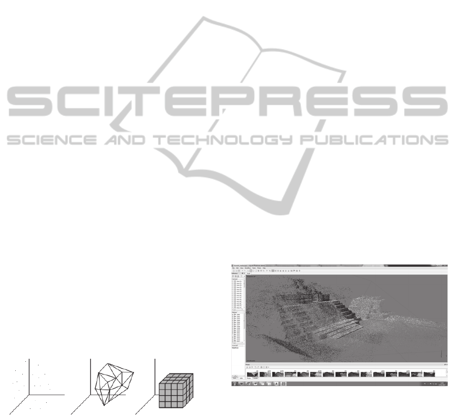
shown in Figure 1.
Figure 1: Point-based, surface-based and solid-based
models (point cloud, wireframe and voxels).
2.1 1D Primitives
Regarding 1D primitives, only one building block is
possible, namely points. The resulting point clouds
can have various sources. They can be the result of
discrete total station or GNSS measurements, a laser
scanning operation or the Structure from Motion and
Multi-View Stereo (SfM-MVS) process that is often
adopted in photo modelling. Moreover, the points
can depict a variety of objects, ranging from
characteristic marks on buildings to a complete
surface.
By importing point clouds in a 3D GIS, the user
would be able to link database data to the distinct
points and perform extensive semantic and
geometric analyses on these points. This can be
exemplified by an excavation where the
archaeologist examines the proximity of certain
objects (e.g. shards) to investigate their coherence
and origin. The main advantage of using point
clouds is that the discrete points represent measured
values and the data has normally not yet been
generalised, giving researchers the chance to
investigate the data in their ‘purest’ form.
Moreover, there are already several (free/open
source) software that allow point cloud analysis to a
certain extent, such as CloudCompare (Figure 2),
AutoCAD Civil 3D and Point Cloud Library.
However, they occasionally consider the point cloud
as a whole and do not allow the user to manipulate
or query one single point as is the case in a regular
GIS. Another alternative in this respect are some
databases that support 3D point coordinates, such as
PostgreSQL (with spatial extension PostGIS),
Oracle Spatial and MySQL. They might provide
researchers with basic tools for analysis but lack the
visualisation possibilities of a full-fledged GIS.
Figure 2: Visualisation of point cloud model of Mayan
temple in Agisoft PhotoScan.
2.2 2D Primitives
Similar to 2D GIS, 3D GIS adopt two types of 2D
primitives, namely lines and polygons, resulting in
wireframe models and meshes, such as TINs. These
models often find their origin in the manipulation of
point clouds. The Delaunay triangulation, for
example, is a well-known algorithm for the creation
GISTAM2015-1stInternationalConferenceonGeographicalInformationSystemsTheory,ApplicationsandManagement
136

of a triangular mesh out of a point cloud (Cheng et
al., 2013). The algorithm tends to maximize the
angles of the resulting triangles and is often used in
computational geometry. In comparison to other
types of polygons, using triangles as a primitive
increases the realism of the final model and allows
the reconstruction of complex structures. TINs
(2.5D) and meshes (3D) thus succeed in approaching
the original shape and look of the modelled object
better than point clouds, as the user can intuitively
understand the context that the model was created in.
When importing meshes or wireframes into a 3D
GIS, several issues arise, the most important one
being the connection to attribute data. It should be
possible to link data to the object as a whole, but
also to a subset of triangles or even one single
triangle. This depends among others on the size of
the object and the goal of the research. When
examining large structures, such as buildings, there
should be a way to distinguish several discrete parts
of the building, such as windows and floors, and link
different attribute data to each part. In other cases, it
can be necessary to treat the object and its
constituting primitives as a whole, with separate
objects having their own separate attribute data.
When every triangle is seen as a distinct feature, the
software should be aware of the coherence of
different triangles and the structures they make up.
In 2D GIS, these relationships are defined through
the use of topology. A similar system should thus be
applied when developing a 3D GIS.
One of the main advantages of using 2D
primitives is that this kind of representation is
already being used very often in non GIS-related
applications and software (e.g. Meshlab, Figure 3).
Not only are there several file formats that the
representation of meshes (and when necessary store
texture), various systems also support these formats
and allow users to quickly import them and visualise
or edit the meshes that they contain.
Figure 3: Visualisation of triangular mesh model of Mayan
temple in Agisoft PhotoScan.
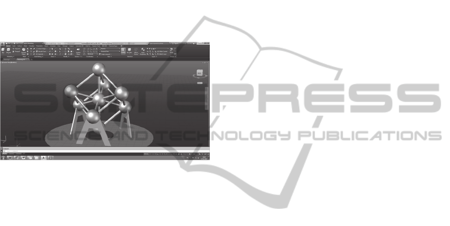
2.3 3D Primitives
When deciding on a suitable 3D primitive, several
choices can be made depending on the source data
and the research goal. For example, when only data
about specific characteristic points of a given object
are provided, the researcher can reconstruct the
object using CAD objects as is the case with CSG
models (Figure 4). When a laser scanning point
cloud is provided, the researcher might opt to
transform the input data into a polyhedron or
tetrahedron model. However, the algorithms that
transform the point cloud into these models are more
complex and less widespread when compared to
those that transform point clouds into a set of 2D
primitives.
Whether or not the resulting model depicts the
object realistically depends on two factors: the input
data and the chosen primitive. When only a few
distinct points are available, CSG models suffice as
they are able to incorporate all points and reduce the
resulting complexity. However, when an entire point
cloud is provided through laser scanning or photo
modelling, basing the reconstruction on CAD
objects would either be inadequate, as this would
reduce the accuracy and realism of the model, or
result in unnecessarily complex models.
The querying possibilities of these 3D models
depend on the chosen primitives as well. The same
issues arise when trying to link attributes to a
tetrahedron model as when trying to link attributes
to a triangular irregular network. As the tetrahedra
are calculated primarily with the goal to match the
input data, it might be hard to distinguish distinct
features in the final model (such as a building’s
floors, windows, etc.). A segmentation or feature
detection algorithm might be required to meet this
goal. A CSG model, on the other hand, is built up of
well-defined features which were decided on by the
user on beforehand. Using these models might
simplify the connection to attributes and thus the
integration into a 3D GIS. Nevertheless, it should be
taken into account that the model might not
represent the input data completely truthfully.
Ideally, both a realistic representation of the object
and a straightforward connection to its defining
attributes should be acquired when using a certain
primitive. Considering validation, realism,
modelling and algorithms, Arens et al. (2005) prefer
polyhedra as 3D primitives when developing a 3D
geo-DBMS.
However, the main drawback of currently using
3D primitives is that there are far less possibilities
compared to 1D and 2D primitives. While laser
DeterminingGeometricPrimitivesfora3DGIS-Easyas1D,2D,3D?
137
scanning and photo modelling software often offer
users the possibility to transform point clouds into
meshes or wireframes, this is not the case for any of
the above 3D primitives. Moreover, there are less
visualisation and editing software available that
support file formats containing these kinds of
primitives. Most applications handling volumetric or
solid models are used in medical imagery analysis
(e.g. MeVisLab and VoluMedic), the gaming
industry (e.g. Blender, Unity) or CAD software (e.g.
AutoCAD). Furthermore, there are some open
source toolkits and derived programs (e.g. VTK and
ParaView) which enable volumetric methods.
Figure 4: Visualisation of volumetric CSG model of
Atomium in AutoCAD.
3 DISCUSSION
Both one-, two- and three-dimensional primitives in
a 3D space have been elaborated in the previous
section. Based on the discussed characteristics,
Table 1 is composed. It evaluates three main aspects
of every primitive: how well/truthfully it represents
or visualises the real-world object, what the
possibilities are when implemented in a 3D GIS (e.g.
1:1 relation object-attributes?) and how well the
primitive is embedded in current practice or 3D
applications. On the one hand, 2D primitives seem
the best fit in many common analyses, due to their
representation possibilities and acceptance in a wide
variety of applications. However, they seem to lack
particular qualities that are necessary when
performing GIS analyses. Certain 3D primitives, on
the other hand, are promising when it comes to their
implementation in a 3D GIS, but are hardly
supported and only used in very specific cases. 1D
primitives, which represent the object in its most
simplified form, have the benefit of already being
available in current geo-DBMS and being supported
by several file formats and software, but have very
limited non-spatial querying possibilities and might
fall short where data visualisation is concerned.
How to decide on what primitive to use mainly
depends on the research goal. Research focused on
the (truthful) representation of objects will probably
benefit most from a mesh model and will thus use a
series of 2D primitives in a 3D space (Table 1),
whereas research that involves volume calculations
and a volumetric representation of the object should
consider the use of a fully 3D primitive. Even when
a certain dimensional complexity is selected, a
choice has to be made regarding the conceptual
model of that primitive. The preference of one type
of primitive over the other is of vital importance to
the further course of the research and will depend
not only on the input data, but also on the desired
output and available software.
However, it is of significant importance that GIS
vendors see the necessity of the implementation of
3D models in their software and consequently
provide users with various tools to visualise, manage
and analyse these models. Common GIS file
formats, such as ESRI’s shapefile, and open standard
geospatial formats, such as GeoJSON, should
incorporate not only 1D and 2D primitives, but also
3D primitives, the possibility to add 3D coordinates
to 1D and 2D primitives and the support for
analysing nD primitives in a 3D space. The open
source community could speed up this process by
either creating their own format, by backing this
evolution or by modifying the GIS possibilities of
current 3D modelling formats. Some of the most
common file formats in this respect are Collada
(.dae), Wavefront OBJ (.obj) and Polygon File
Format (.ply). Moreover, the Virtual Reality
Modeling Language (.wrl) and Extensible 3D (.x3d)
format are being recognised as ISO standards. These
formats can be imported in mesh editing software
such as MeshLab, but as well in game engines and
CAD software (e.g. Blender, AutoCAD). Most
formats, however, do not support attribute data or
even the explicit definition of a coordinate system.
It can also be questioned if a new, 3D GIS-
specific file format should support every possible 3D
primitive or limit itself to one specific type of 3D
primitive. This would of course narrow the
possibilities of such a format, but might also have
the advantage of being straightforward, whereas the
opposite might cause confusion when a specific set
of operations is available for one primitive but not
for another.
Another concern should be the lifespan of such a
format. It is important that this format is accepted by
the GIS community in order for it to be successful
and used over a large period of time. This is closely
GISTAM2015-1stInternationalConferenceonGeographicalInformationSystemsTheory,ApplicationsandManagement
138

Table 1: Overview of potential geometric primitives – advantages and drawbacks.
Dimensions Primitive Representation 3D GIS Current situation
1D Point +/- +/- +
2D
Line
Polygon
+ +/- +
3D
Tetahedron
Polyhedron
Polyhedron combined with
spherical and cylindrical
patches
CAD objects
+ +/- +/-
connected to the chosen primitive and can thus
influence the preference for one primitive over the
other.
4 CONCLUSIONS
As a result of the rising interest in 3D models, the
need for the development of a 3D GIS increases.
Before such a system can be conceived, several
initial issues have to be tackled, such as the decision
on a geometric primitive through which the models
will be imported into the software. 1D (point) and
2D (line and polygon) primitives are well known
and their use in both 2D and 3D applications is
widespread. However, they seem to lack certain
qualities that influence both the visualisation of the
objects that they represent and the implementation
and analytical possibilities of these objects in a 3D
GIS.
Consequently, some thought should go into the
implementation of 3D primitives, and their possible
integration into standard GIS file formats. These 3D
primitives can form either tetrahedral, polyhedral or
CSG models (using CAD objects). All of these
primitives have certain advantages and drawbacks
and the preference for one primitive over the other is
based not only on the desired outcome, but also on
the available input data (characteristic points vs
extensive point cloud). 3D primitives have the
advantage that they allow volumetric representations
and operations and thus show the object in the same
way as it is also perceived in the real world.
It is thus of great importance that GIS vendors
see the necessity of the implementation of 3D
models in their software. The open source
community can play a vital role in this process, as
they are usually at the forefront of technical
developments. Implementing 3D primitives into new
or existing file formats and software may seem a
considerable challenge. However, the possibilities
and the progress this encompasses can encourage
researchers dedicated to several domains and
working on diverse projects to appreciate 3D models
in new ways and even rethink the way in which 3D
models are conceived.
5 FUTURE RESEARCH
This position paper conveys an initial overview of
the possibilities of several geometric primitives in
light of the development of a 3D GIS. Future
research will focus on the use of 3D geometric
primitives (e.g. tetrahedra, CSG objects, voxels,…)
in such a GIS. It will thus incorporate two aspects:
(1) the conversion of existing 3D point clouds into
volumetric 3D models using CAD, BIM and reverse
engineering techniques, (2) an extensive overview of
the advantages and drawbacks of the applied
geometric primitives, focusing on their future use in
a 3D GIS and based on both a theoretical and
empirical pillar. If possible, the use of open source
software will be favoured.
ACKNOWLEDGEMENTS
Financial support from the Special Research Fund
from Ghent University and the Research Foundation
Flanders (FWO) is gratefully acknowledged.
REFERENCES
Abdul-Rahman, A., Pilouk, M., 2008. Spatial Data
Modelling for 3D GIS, Springer. Berlin, 1
st
edition.
Arav, R., Filin, S., Avner, U., Bar-Oz, G., Nachmias, A.,
Nadel, D., 2014. Use of terrestrial laser scans for high
resolution documentation and 3D modelling of ‘desert
kites’. In Near Eastern Archaeology, vol. 77, no. 3,
pp. 219-222.
Arens, C., Stoter, J., van Oosterom, P., 2005. Modelling
3D spatial objects in a geo-DBMS using a 3D
primitive. In Computers & Geosciences, vol. 31, no. 2,
pp. 165-177.
DeterminingGeometricPrimitivesfora3DGIS-Easyas1D,2D,3D?
139

Cheng, S., Dey, T., Shewchuk, J., 2013. Delaunay mesh
generation, CRC Press. Boca Raton, 1
st
editon.
De Roo, B., Ooms, K., Bourgois, J., De Maeyer, P., 2014.
Bridging archaeology and GIS: influencing factors for
a 4D archaeological GIS. Paper presented at 5
th
International conference on Cultural Heritage
(EuroMed 2014), Limassol, 3-8 November.
Frank, A., 2008. Requirements for 3D in geographic
information systems applications. In van Oosterom, P.,
Zlatanova, S., Penninga, F., Fendel, E. (Eds.)
Advances in 3D Geoinformation Systems. Berlin
Heidelberg: Springer.
Ghali, S., 2008. Introduction to Geometric Computing,
Springer eBooks. London, 1
st
edition.
Heras Barros, V., 2014. Towards a GIS based monitoring
tool for a preventive conservation management of the
world heritage city of Cuenca. Unpublished PhD
thesis. Katholieke Universiteit Leuven, Leuven.
Hijazi, I., Ehlers, M., Zlatanova, S., 2010. BIM for geo-
analysis (BIM4GEOA): set up of 3D information
system with open source software and open
specification (OS). In Kolbe, T., König, G., Nagel, C.
(Eds.) ISPRS Archives, vol. XXXVIII-4/W15, pp. 45-
49.
Pasciak, A., Erwin, W., 2009. Effect of voxel size and
computation method on Tc-99m MAA SPECT/CT-
based dose estimation for Y-90 microsphere therapy.
In IEEE Transactions on Medical Imaging, vol. 28,
no. 11, pp. 1754-1758.
Pouliot, J., Lachance, B., Kirkwood, D., 2006.
L’importance de la modélisation géométrique 3D lors
de l’élaboration d’un SIG 3D: Exemple du
développement d’une structure topologique pour une
application géologique”. In Revue Internationale de
Géomatique, vol. 16, no. 1, pp. 29-49.
Radua, J., Canales-Rodriguez, E., Pomarol-Clotet, E.,
Salvador, R., 2014. Validity of modulation and
optimal settings for advanced voxel-based
morphometry. In NeuroImage, vol. 86, pp. 81-90.
Rua, H., Alvito, J., 2011. Living the past: 3D models,
virtual reality and game engines as tools for
supporting archaeology and the reconstruction of
cultural heritage – the case-study of the Roman villa of
Casal de Feiria. In Journal of Archaeological Science,
vol. 38, no. 12, pp. 3296-3308.
Siebert, S., Teizer, J., 2014. Mobile 3D mapping for
surveying earthwork projects using an Unmanned
Aerial Vehicle (UAV) system. In Automation in
Construction, vol. 41, pp. 1-14.
Vanneschi, C., Salvini, R., Massa, G., Riccucci, S.,
Borsani, A., 2014. Geological 3D modelling for
excavation activity in an underground marble quarry
in the Apuan Alps (Italy). In Computers &
Geosciences, vol. 69, pp. 41-54.
von Schwerin, J., Richards-Rissetto, H., Remondino, F.,
Agugiaro, G., Girardi, G., 2013. The MayaArch3D
project: a 3D webGIS for analysing ancient
architecture and landscapes. In Literary and Linguistic
Computing, vol. 28, no. 4, pp. 736-753.
Wu, Q., Xu, H., Zhou, W., 2008. Development of a 3D
GIS and its application to karst areas. In
Environmental geology, vol. 54, no. 5, pp. 1037-1045.
Zlatanova, S., Abdul-Rahman, A., Pilouk, M, 2002.
Trends in 3D GIS development. In Journal of
Geospatial Engineering, vol. 4, no. 2, pp. 71-80.
GISTAM2015-1stInternationalConferenceonGeographicalInformationSystemsTheory,ApplicationsandManagement
140
