
TORCIA
A Decision-support Collaborative Platform for Emergency Management
Chiara Francalanci and Paolo Giacomazzi
Dept. of Electronics, Information and Bioengineering, Politecnico di Milano, P.zza Leonardo da Vinci 32, Milano, Italy
Keywords: Emergency Management, Crisis Management, Social Media, Twitter, Semantic Engine.
Abstract: The TORCIA platform has been developed as part of a project funded by the Lombardy Region. The main
goal of the project is the development of a tool that leverages social media in emergency management
processes. With a continuous and real-time collection of information from social media, TORCIA can detect
situations of potential emergency and identify their geographical position. The TORCIA platform supports
emergency operators from different organizations and institutions with a decision-support dashboard and
favors the creation of a collaborative process combining the contributions of citizens and institutions by
means of a mobile app that is also integrated within the platform.
1 INTRODUCTION
TORCIA is a project funded by the Lombardy
Region (Italy) with the support of the European
Fund for Regional Development. The main goal of
the project is the development of a software platform
that leverages social media in emergency
management processes and, more generally, in the
planning and control processes of crisis situations
(e.g. accidents or natural disasters), with a focus on
roads and transportation issues. The project has
started in June 2012 and ended in June 2014. The
partnership of the project includes Alcatel-Lucent,
main contractor of TORCIA, the Department of
Electronics, Information and Bioengineering (DEIB)
of Politecnico di Milano, scientific coordinator of
TORCIA, Fondazione Politecnico di Milano, ACT
Solutions, Beta 80 and Vidiemme.
Italian cities, on the basis of their local
specificities, have defined plans to respond to
possible emergencies designed in cooperation with
the National Civil Protection. These plans include a
series of tasks, roles and policies to be enacted in
case of a given natural or man-made emergency
situation. The transport network is a key
infrastructure to be managed in emergency
situations. The emergency plans of the Civil
Protection can include a number of changes to the
transport infrastructure in case of emergency, such
as the direction of travel in specific avenues or
highways, or access restrictions to specific areas that
are needed by emergency vehicles. Ensuring safety
is key to an effective management of emergency
situations and controlling the transport infrastructure
is among the main drivers of safety.
In this context, the TORCIA project aims at
supporting the collection of information that allows
institutions to detect critical situations that could
cause an emergency and to make decisions that
decrease the risk of emergencies as well as their
consequences when they cannot be avoided. Citizens
involved in an emergency situation that are also
Web 2.0 users can provide an important contribution
to emergency management by sharing information
on social networks, Facebook and Twitter above all.
In order to collect, organize and interpret this
information and make it useful to the emergency
management teams, the TORCIA project has
implemented a software platform that is based on a
geographically distributed cloud infrastructure
connected by a broadband optical network. TORCIA
can take advantage of the cooperation of citizens by
analyzing the information that they share, using
social networks according to an overall information
workflow that is integrated and technically
innovative. Figure 1 shows the technical architecture
of the TORCIA platform.
2 RELATED WORKS
Leveraging social media to improve disaster
225
Francalanci C. and Giacomazzi P..
TORCIA - A Decision-support Collaborative Platform for Emergency Management.
DOI: 10.5220/0005499202250231
In Proceedings of 4th International Conference on Data Management Technologies and Applications (DATA-2015), pages 225-231
ISBN: 978-989-758-103-8
Copyright
c
2015 SCITEPRESS (Science and Technology Publications, Lda.)
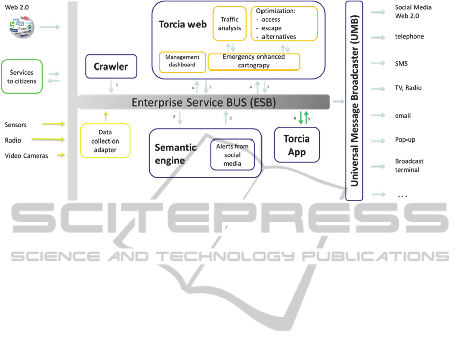
Figure 1: Architecture of the TORCIA platform.
management processes has attracted the attention of
researchers in several different areas (Purohit, 2013).
On one hand, there is a whole body of literature
focusing on how to integrate social media into
official emergency management plans and practices
(Brughemans, 2012). This literature points to the
challenges raised by social media and their unique
collaboration features.
On the other hand, significant research
contributions focus on the technical issues to be
addressed in order for social media information to be
fully exploited. The technical challenges with
gathering, analysing, and sharing social information
span from the identification of relevant information
from a potentially overwhelming number of social
media messages to classifying the conversation
topics and locating the geographical areas impacted
by the emergency. For example, authors of
(Saravanou, 2015) provides a methodology to
identify the areas that have been hit the most by a
disaster based on geographical clustering. In (Imran,
2015), tweets are analysed semantically to
dynamically gather the topics of social
conversations. The assessment of the damaged
caused by a disaster is performed automatically
based on social media information in (Cresci, 2015).
The TORCIA project is positioned in this second
stream of literature, focusing on technology rather
than processes. The main contribution of the
TORCIA project is to provide an end-to-end
platform that integrates multiple technical
components that are typically designed and tested in
isolation in previous literature (see Figure 1). The
technical components of the TORCIA platform are
coordinated according to the TORCIA workflow,
which represents an overall approach to the
management of the social information lifecycle
during. By integrating multiple technical
components and testing the platform on several real
emergencies over a two-year time frame, TORCIA
has proved to be able not only to effectively gather
and classify information, but also to raise alerts with
a significant time advantage compared to the
standard alert channels.
3 SOCIAL MEDIA
The TORCIA workflow starts from the real-time
continuous collection of information from the most
important social media (for a high-level visual
description of the TORCIA workflow see http://sos-
torcia.it/it/news/141-il-video-del-progetto-
torcia.html). The first research question that has
been faced is whether social media can really
provide information that is relevant in the context of
emergency management and useful to reach our
project objectives. The answer to this question is yes
if social media users, that is citizens, talk about
emergency situations on social media and if that
buzz can be useful for emergency management.
These conditions have been verified as part of a
preliminary feasibility analysis that has been
conducted at the beginning of the TORCIA project
and is summarized in the following.
A first, straightforward consideration is that is if
an emergency occurs in a scarcely populated
geographical site, it is very likely that there is not a
DATA2015-4thInternationalConferenceonDataManagementTechnologiesandApplications
226
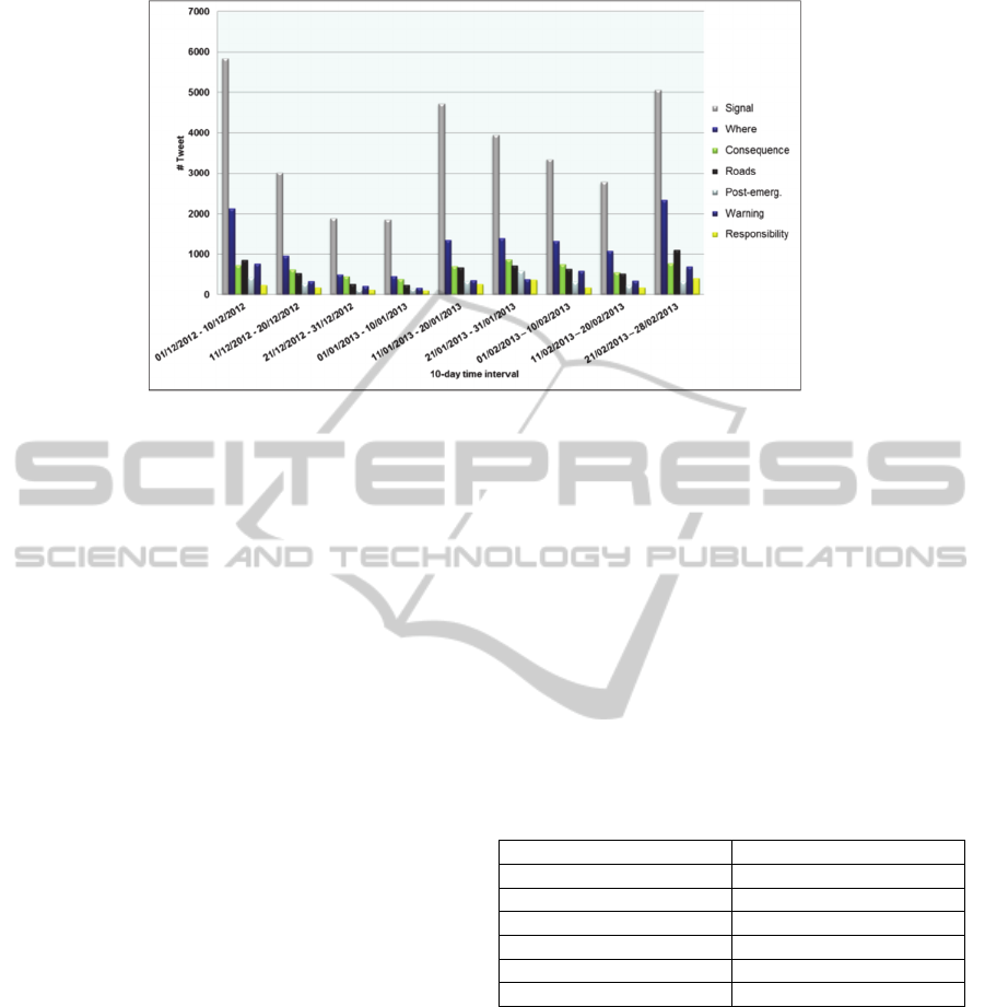
Figure 2: Topics of buzz on floods (buzz in Italian).
sufficient number of social media users among the
citizens involved and, as a consequence, social
media will provide very little or no information. For
example, a landslide blocking a solitary mountain
path is very likely not to receive attention on social
media by the few people involved. Conversely, a
landslide in a famous path (such as the landslide that
has blocked the “love path” at the Cinque Terre in
Italy in 2013) will be immediately signalled on
social media. In general, the higher the number of
people involved in a same emergency situation, the
greater the value of social media information in the
management of that emergency. We have chosen to
focus on the most favourable scenario, that is city
emergencies and, in particular, floods, which have
recently become more frequent, especially in Italy,
and, thus, suitable to provide numerous test cases
within the time frame of our project. With reference
to floods in the context of a city, we have conducted
our preliminary analysis with the following
objectives: (1) verify the volumes of buzz on floods,
particularly from Twitter; (2) analyze the topics of
the buzz on floods; (3) verify whether the buzz on
floods provides information useful to geolocalize the
emergency; (4) evaluate the presence of the
institutions on social media, particularly on Twitter;
(5) compare the Italian case with international best
practices. Crawling, i.e. the collection of posts from
social media, has started in September 2013 on
roughly 60 keywords that define the domain of
interest, i.e. floods, in Italian and English. A sample
list of english keywords is reported in Table 1.
Overall, we have collected over 40 million tweets
during the project. The volumes of buzz reported in
Table 1 represent the number of occurrences of each
keyword in the Italian language in a typical day with
bad weather (without any real emergency situation).
It can be noted how buzz concentrates on a subset of
keywords. Our preliminary qualitative analyses of
buzz have shown that the subset of most frequent
keywords tends to change over time, as a
consequence of the changing weather, but also as a
result of a tendency to imitate each other in the
choice of terms when describing common weather
conditions. A first finding is that the volumes of
buzz in the flood domain in Italian are significant,
on average 40,000 tweet/month and worth of further
analysis (see also (Rossitto, 2012)).
Table 1: Crawling keyword used for data collection and
related number of daily occurrences.
Term Number of occurrences
Flood/s, flooding 362
Hailstorm/s, hail 96
Storm/s 337
Lanslide/s 792
Hurricane 69
Cloudburst 62
Our next step has been to analyze the social media
buzz on floods in order to gather the most frequent
topics (Cesana 2012).
The goal was to verify whether social media
buzz includes information that could be potentially
interesting in emergency management (Cameron,
2012), (Shih, 2012). The most frequent topics are:
(a) Signal, i.e. posts signaling bad weather
conditions and evaluating their severity (from mere
inconvenience to warning of a potential or ongoing
emergency situation). (b) Where, i.e. posts explicitly
referring to the place where the user is experiencing
bad weather conditions. (c) Consequence, i.e. posts
describing facts that have occurred as a consequence
TORCIA-ADecision-supportCollaborativePlatformforEmergencyManagement
227

of bad weather conditions (flooding, landslide,
collapse of a building, etc.). (d) Roads, i.e. posts
reporting on traffic and road conditions. (e) Post-
emergency, i.e. posts commenting on recent events
that have created emergency situations, often with
reference to ongoing activities aimed at restoring
normal conditions.
(f) Warning, i.e. posts commenting on bad
weather forecasts or informing on the potential risks
associated with future bad weather conditions. (g)
Responsibility, i.e. posts expressing opinions on the
causes and related responsibilities of the
consequences of bad weather conditions.
Figure 2 reports the distribution of buzz into the
topics discussed above. It can be noted how buzz
concentrates on the signal category, which, in turn,
indicates a prevalence of social interactions during
the emergency, as opposed to the phases preceding
and following the emergency. The fact that pre- and
post-emergency receive a lower degree of attention
is partly related to a very limited presence of Italian
institutions and authorities on Twitter. It can also be
noted that the volumes of buzz in the where and
roads categories are significant. This indicates that
social media buzz may provide information useful
for the definition of the geographical zone impacted
by the emergency and for the assessment of the
conditions of the road infrastructure.
Overall, these observations indicate that: (1) The
collection and analysis of information from social
media, Twitter in particular, should be performed in
real time, given the high percentage of posts shared
during the emergency (a time frame of a few hours).
(2) The information that is collected can indeed
provide useful insights on the geographical position
and extent of the emergency and, to a more limited
degree, on issues with the road infrastructure.
4 THE SEMANTIC ENGINE
Not all information is useful for emergency
management. Roughly half of the information that is
collected syntactically by means of crawling
keywords is not related to the domain. Figure 3
shows how the floods domain is not an exception,
indicating that 50% of the posts collected with the
crawling keywords exemplified in Table 1 are not
discussing flood-related issues. In the TORCIA
architecture (see Figure 1), the semantic engine
(Carcaci, 2012) is in charge of the identification and
removal of irrelevant information. The semantic
engine classifies relevant posts into the topics shown
in Figure 3 (also called categories). This
classification is performed by a software module
based on a semantic network that associates
metadata with each topic and weighs them according
to their importance in the application domain. Table
2 shows a few instances of the metadata supporting
the classification activity. The selection of metadata
and the tuning of weights in the semantic network
have been repeated several times during the project
to continuously improve the quality of the
classification process.
Finally, the semantic engine analyzes the
information that has been previously cleaned and
classified in order to identify situations of potential
or ongoing emergency. In the first case (potential
emergency), the engine raises an alert, while in the
Figure 3: Volume of posts collected syntactically vs. Volume of posts relevant to the floods domain (example).
DATA2015-4thInternationalConferenceonDataManagementTechnologiesandApplications
228

second case (ongoing emergency) it raises an alarm.
The identification of a potential or ongoing
emergency is based on the detection of peaks in the
volumes of buzz compared to the average volumes.
We have observed how not all peaks correspond to
an actual emergency situation, either potential or
ongoing, and, therefore, setting volume thresholds to
create alerts or alarms results into an overwhelming
number of false positives which is significantly
higher that the correct signals. For example, bad
weather conditions in a vast zone of the national
territory causes a considerable increase in the
volumes of posts, but in most cases those peaks do
not correspond to emergencies. Those peaks can be
even higher than the levels of buzz during a real
emergency impacting on a specific geographical
zone, such as the volumes reached during the flood
experienced by the city of Catania (Sicily, Italy) in
2013 or by the Island of Sardegna in 2014. Both
floods have been severe and have generated
corresponding peaks that we have been able to
identify by combining two thresholds: 1) a threshold
on the overall volumes of buzz and 2) a second
threshold on volumes of posts consistently referring
to the same geographical zone (e.g. a region, such as
Sardegna) or place (e.g. a city, such as Catania).
This second threshold is applied to posts in the
“where” and “roads” categories (see Figure 2). The
identification of geographical zones or places is
supported by a geographical mapping service
designed by Vidiemme, a partner in the TORCIA
project. Given that the majority of users disable their
Table 2: Topics and sample metadata.
Topics Metadata (examples)
Where City, Center, Road, Underground,
North, Spain, Venice, Site, Town,
Citym Region, Zone…
Signal Flood, Rain, River, Water, Storm,
Thunderstorm, Hailstorm,
Hurricane, Cloudburst…
Consequence Dead, Rescue, Landslide,
Situation, Damage, Collapse,
Drown…
Responsibility Police, Judge, Court, Fire
brigades, Manager, Ministry,
Civil Protection, City Hall…
Roads Open, Closed, Accessible, Clear,
Blocked, Congested…
Warning Risk, Danger, Forecast, Sewer,
Clogged, River bank, Dam,
Dyke…
Post emergency Refund, Complaint, Money,
Fund, Statement, Notification,
Charge, Restoration,
Reinstallation…
smartphone’s location service, geographical
information is gathered from text. tweets are cross-
checked with the geographical mapping service to
verify whether they are names of places.
5 THE DASHBOARD
Alerts and alarms are conveyed to the management
dashboard (implemented by Beta80, partner of the
TORCIA project). During the project, we have been
able to test the TORCIA architecture on several
emergency situations, including: (1) Flood, Catania
(Italian city), February 2013; (2) Flood, Vicenza
(Italian city), May 2013; (3) (first) cloudburst, Rome
(Italian city), July 7/8 2013; (4) (second) cloudburst,
Rome (Italian city), July 21/22 2013; (5) (third)
cloudburst, Rome (Italian city), July 27/28 2013; (6)
Flood, Tuscany (Italian region), October 21/22
2013; (7) Flood, Sardegna (Italian region),
November 2013; (8) Flood, Marche (Italian region),
April 2014; (9) Flood, Senigallia (Italian city), May
2014; (10) Flood, Seveso (Italian river), September
2014.
By analyzing these emergencies, we have
realized that buzz on social media is not
straightforward to use, unless it is organized, i.e.
disambiguated, categorized and geolocalized. This
analysis allows users to obtain interesting
information that complements that obtained from
more traditional information sources that are
commonly used by institutional operators. With
reference to the flood in Catania (see list above),
The alerts raised by the semantic engine are notified
to the management dashboard with a significant time
advance compared to the time when the official alert
is broadcasted by the Civil Protection (a few hours).
For example, in the Catania flood (February 2013),
the official alert is at 6 PM, while the TORCIA alert
would have been raised at 4:15 PM. A similar time
advance has been consistently found for all the
emergencies that have been considered for testing.
However, the management dashboard is strongly
user-centric. All information, including alerts and
alarms, are proposed to the user, assuming that
he/she has to manually validate it. This validation is
considered necessary both because the semantic
engine, notwithstanding our continuous refinement,
is subject to errors, and because not all social
information is dependable. The quality of
information can benefit from the insight of an
expert, for example a civil protection operator, who
has access to all information sources, as opposed to
social media only.
TORCIA-ADecision-supportCollaborativePlatformforEmergencyManagement
229

6 THE MOBILE APP
The information organized by the semantic engine
and validated by operators is made available to
citizens by a mobile application (implemented by
Beta80, a partner of the TORCIA project). In the
TORCIA architecture, the mobile application
represents the medium with which citizens and
institutional operators cooperate before, during, and
after an emergency (Estelles, 2012).
It constitutes a coordination tool and, for the
institutions, a crowdsourcing mechanism. Through
the app, citizens can access validated information
and, directly from the app, they can contribute with
additional information which can be addressed to the
operators, to Twitter, or both. Operators can collect
information from citizens in real time and, in turn,
send institutional messages critical for emergency
management. With the registration mechanism, the
users of the mobile app represent a set of selected
citizens whose identity is known to the TORCIA
system. In case of recurring emergencies, the app
can build a profile of mobile app users and design
cooperation processes that assign specific roles to
users depending on their profile characteristics. For
example, it is possible to assess the frequency and
impact of user contributions, with well-known user
scoring mechanisms, and implement automated
evaluations of user influence and dependability
based on the scores (Cha, 2010).
Through the app, mobile users can access the
same geolocalized information that is available to
institutional operators through the management
dashboard. In fact, institutional operators can be
users of the mobile app (Capelli, 2013) and, as a
consequence, the app can also be used as an on-site
coordination tool.
7 CONCLUSIONS
The TORCIA workflow starts with the real-time
collection of information from the main social
media. This information is analyzed by a semantic
engine that can identify and geolocalize potential or
ongoing emergency situations based on the online
buzz. When it identifies a potential emergency
situation, the semantic engine sends an alert to a
management dashboard that has been designed for
institutional operators, such as the Civil Protection.
If the alert is validated by an operator, an emergency
alarm is created and emergency management
procedures are activated. In particular, within the
TORCIA platform, it is possible to communicate
with citizens with a multi-channel approach, by
including social media among the set of active
communication channels. Citizens can use the
mobile app to obtain information on the emergency
situation. For example, they can access all the
information that the crawler collects from social
media, provided that it is previously disambiguated,
classified and geolocalized by the semantic engine.
They can request the app to calculate escape routes
based on their current position as well as operating
constraints imposed by institutional operators (this
software module has been developed by ACT
solutions, a partner of the TORCIA project).
REFERENCES
Capelli, P., 2013, “A Methodology for the Classification
of the competitive models of mobile applications,”
Graduation Thesis in Computer Engineering (in
Italian), Politecnico di Milano, Dec. 2013.
Carcaci, C., 2012, “Syntactic text classification with set
theory”, Graduation Thesis in Computer Engineering
(in Italian), Politecnico di Milano, Dec. 2012.
Cesana, G. , D’Ettorre, A. “Analisi, Metodologia e
Sviluppo di un Sistema Integrato per la Gestione delle
Emergenze in Ambito Social”, Graduation Thesis in
Computer Engineering (in Italian), Politecnico di
Milano, Sept. 2012.
Rossitto R., 2012, “Twitter’s numbers in Italy”, Wired, 26,
Sept. 2012, http://daily.wired.it/news/internet/2012/
09/26/numeri-twitter-italia.html.
M. Cameron, R. Power, B. Robinson, and J.Yin., 2012,
“Emergency situation awareness from twitter for crisis
managment. In SWDM Workshop, 305-308, Lyon,
France, 2012.
E. Estelles, F. Gonzalez, 2012, “Towards an integrated
crowdsourcing definition,” Journal of Information
Science, 38(2), 189-200, 2012.
M.Cha, H.Haddadi, F.Benevenuto, and K.P.Gummadi,
2012, “Measuring user influence in twitter: The
million follower fallacy,” In Proceedings of
international AAAI Conference on Weblogs and
Social, 2010.
G. Shih, 2012. “In hurricane, Twitter proves a lifeline
despite pranksters,” Reuters, 2012.
B. Brughemans, 2012, “Using Information from Social
Media for Emergency Management,” EENA Thematic
Newsletters, http://www.eena.org/uploads/gallery/
files/doc/socialmedia.pdf.
A. Saravanou, D. Gunopulos, G. Valkanas, G. Andrienko,
2015. “Twitter floods when it rains: a case study of the
UK floods in early 2014,” Workshop Series on Social
Web for Disaster Management, Florence (IT), May
18-22, 2015.
M. Imran, C. Castillo, 2015. “Towards a data-driven
approach to identify crisis-related topics in social
media streams,” Workshop Series on Social Web for
DATA2015-4thInternationalConferenceonDataManagementTechnologiesandApplications
230

Disaster Management, Florence (IT), May 18-22,
2015.
S. Cresci, M. Tesconi, A. Cimino, F. Dell’Orletta, 2015.
“A linguistically-driven approach to cross-event
damage assessment of natural disasters from social
media messages,” Workshop Series on Social Web for
Disaster Management, Florence (IT), May 18-22,
2015.
H. Purohit, P. Meier, C. Castillo, A. Sheth, 2013.
“Tutorial: Crisis Mapping, Citizen Sensing and Social
Media Analytics- Leveraging Citizen Roles for Crisis
Response Coordination,” ICWSM 2013,
http://www.knoesis.org/hemant/present/icwsm2013.
TORCIA-ADecision-supportCollaborativePlatformforEmergencyManagement
231
