
From Medieval Data to Geo-resources on the Web
An Innovative Way of Mapping History
Guido Minini
Department of Civil and Environmental Engineering, Politecnico di Milano, Piazza Leonardo Da Vinci 32, Milano, Italy
guido.minini@polimi.it
1 RESEARCH PROBLEM
This research project is being carried on in the
Geodesy and Geomatics area of a Ph.D program in
Environmental and Infrastructure Engineering. It
raises from a Research Project of National Interest
funded by the Italian Ministry of University and has
the aim to equip Historians with a tool that can
facilitate their work in terms of consulting historical
archives. This project has been dealt with by using a
cognitive approach, in order to identify the key
issues and the appropriate tools to help the
Historians in satisfying their research needs.
In the first phase of the project data collected
from historical sources have been organized into
table archives; these data have been associated with
spatial information (point coordinates),
corresponding to the place names found in historical
sources: knowing the spatial reference it is possible
to import data into a Geographic Information System
(GIS), to display their location on the area of interest
and to overlay them with existing base maps. The
data used for the project date back to the late Middle
Ages (mid-Fifteenth Century) and represent fiscal
information, related to various kinds of taxes paid to
different Kings or Princes in the Kingdom of Naples.
The second phase has been related to the creation
of a relational database to be populated with the
data: as compared with a basic single-table structure,
for example implemented with a standard
spreadsheet, a relational database has the great
advantage to make data query and retrieval much
more efficient, eliminating also unnecessary
redundancies. The relational database design is
achieved through the definition of the Entity-
Relationship Diagram (ERD): in it, data are divided
into different “entities”, corresponding to different
data tables or “relations”, which can be put into
“relationship” among each other, using simple
identification codes.
In the third phase of the project, that has been the
main focus of the Ph.D. program activities, the
problem to be resolved is how to publish these data
in the Web, in order to make them available for the
consultation and query by Historians. Two kinds of
approaches have been explored. The first one is
typical of the WebGIS architecture, in which all the
data and the GIS tools needed to analyse them are
stored in a server and published on the Web, so that
the only client-side software requested is a Web
Browser. The second one is again based on a client-
server architecture, but in this case only the data,
collected into and managed by a Database
Management System (DBMS), are stored in a
server; the GIS tools are provided by a Desktop GIS
installed locally on a PC.
In the next chapters these two architectures will
be described in more detail, comparing them in order
to underline advantages and disadvantages of each
approach.
It is important to state that this research work
presents several challenges, especially from the
point of view of understanding the requirements of
the System’s users. In fact, Medievalist Historians
appear to be usually not well acquainted with GIS
technologies; so defining e.g., a proper conceptual
model fit for XV Century data or implementing
tailored queries represents a major task from the
Geomatics point of view. Several such issues have
been discussed in (Carrion et al., 2015, in press).
2 OUTLINE OF OBJECTIVES
One of the aims of the project is to create a GIS that
can be useful for Historians to draw maps from
historical data in order to study the territorial
dynamics emerging from the historical sources,
achieving a cartographical representation of the
spatial distribution of historical information.
Besides, the possibility to share data among History
research groups is another goal and a feature that
must be added to the system, through the publication
of the Medieval geo resources in the Web.
Currently three historical sources have been
collected into the DBMS:
7
Minini G..
From Medieval Data to Geo-resources on the Web - An Innovative Way of Mapping History.
Copyright
c
2015 SCITEPRESS (Science and Technology Publications, Lda.)

the Liber Focorum Regni Neapolis, produced by
the financial offices of Alfonso V of Aragon in
the 1440s, after his conquest of the Neapolitan
kingdom;
the Quaterni declaracionum, produced between
1446 and 1463 by the leading Treasury officials
(the magistri rationarum) of the last Prince of
Taranto, Giovanni Antonio Orsini del Balzo, the
greatest feudal vassal of the kingdom (Pizzuto,
2009);
the Quaternus decimarum, drawn up in 1478 by
Paolo Vassallo, bishop of Aversa, that registers
the payments of the Decima, a tax related to
ecclesiastical benefits (Mangia, 2013).
The relational database architecture is useful for
representing this type of data, because it allows to
subdivide the information into smaller parts, making
easier to analyse and query them.
Regarding the GIS technologies to be exploited,
it has been decided to use only open source
software: this goal raises from the need to develop
and maintain the system for a long period with
limited economical resources.
Another important objective pertains the ease of
use of the GIS, because the end users are not GIS
experts, so the system must be complete but also
simple and intuitive to use.
3 STATE OF THE ART
GIS design for historical information analysis is a
rather new achievement, see e.g. (Schlichting, 2008).
At the international level, many works have to be
mentioned, see e.g. (Gregory, 2002), (Gregory et al.,
2002), (Berman, 2005) and (Gregory and Healey,
2007), being the main references for this kind of
research. In Italy some examples of GIS
methodologies applied to the analysis of ancient
maps can be found: (Balletti et al., 2000), (Balletti,
2000), (Baiocchi and Lelo, 2002) and (Balletti,
2006). However the latter works rather address the
urban-historical analysis and the methods for
adapting ancient maps to present-day maps through
geometrical transformations.
Many examples of historical data organized into
national atlases can be found, see e.g (Pawson,
1997) and (Black, 2003); in some cases data are
structured into relational databases, to be managed
into a GIS environment, see e.g. (Ardissone and
Rinaudo, 2005); in most cases they are related to
census data and rarely they date before the XVI
century: (Boonstra et al., 1995), (De Moor and
Wiedemann, 2001), (Fitch and Ruggles, 2003).
It is possible to find some examples of historical
data organized into a GIS and published on the
Internet, such as the China Historical GIS
(http://www.fas.harvard.edu/~chgis/) or the northern
Italy cadastral map WebGIS (Brovelli et al., 2012).
Another interesting example published on the Web
is constituted by the “E 179 database”,
(http://www.nationalarchives.gov.uk/e179/) which
contains records relating to lay and clerical taxation
and which is included into the United Kingdom
National Archives. However, in this case the
geographic component is not made explicit into a
map.
Finally, the research developed and presented in
this paper starts from previous works by (Carrion
and Migliaccio, 2009) and (Barzaghi and Carrion,
2011).
4 METHODOLOGY
This project required a close cooperation between
Geomatics experts and Historians, in particular for
the data collection, data organization and design of
the ERD. Historical know how is fundamental
during the phase of extraction of data from historical
archives and translation of the information into
digital format (typically into a spreadsheet). Also the
conceptual model of the database must be planned
and designed in cooperation with Historians, in
order to understand their needs and the meaning of
the collected information (in particular the
preparation of a data dictionary is necessary).
The participation of Historians in the discussion
about the issues related to the publication of data is
again very fundamental, because they are the end
users of the GIS, so it is important to understand
what tools can be useful for them. Obviously,
technical aspects of the GIS publication concern
only Geomatics experts, and this is the main topic
discussed in this paper.
4.1 Historical WebGIS
The first type of GIS architecture approach adopted
to publish the Medieval data has been an Historical
WebGIS. The WebGIS (mainly developed in the
context of another Ph.D. thesis, see (Zambrano,
2013)) has been the starting point of the research
work presented in this paper. As already said, it is
based only on open source software; its architecture
is shown in Figure 1.
The server side is stored in an Ubuntu Linux
GISTAM2015-DoctoralConsortium
8
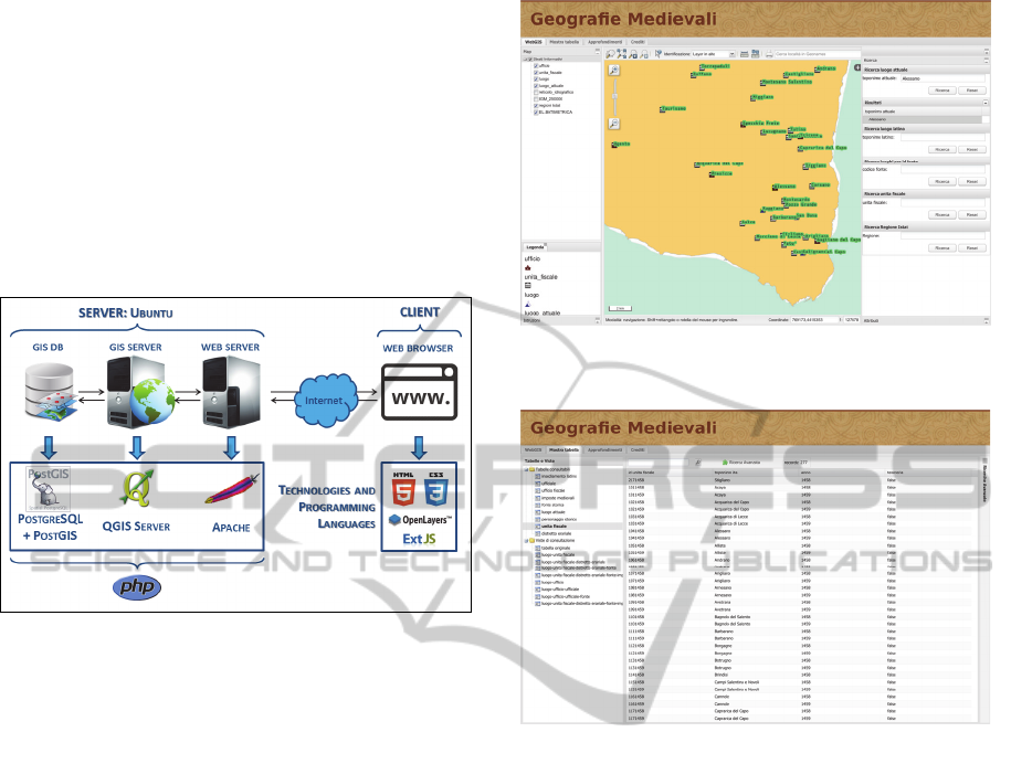
virtual machine and is composed by three modules:
a DBMS, a GIS Server and a Web Server.
The DBMS used is PostgreSQL, an open source
software that can be integrated with a PostGIS
extension, which manages the geographical
information stored in the database and allows to
interact with QGIS Mapserver, a WMS server that
takes advantage of the QGIS libraries and uses the
.qgs projects created with QGIS Desktop. The GIS
server is invoked by the Apache Web Server, whose
task is to publish web pages.
Figure 1: Architecture of the Historical WebGIS.
The client side is entrusted to a Web Browser,
which interprets the web pages written in HTML5
language. The three components of this language are
HTML, CSS and Javascript: they manage contents,
customization and behavior of web pages. The
Javascript toolkit GeoExt was used: it is composed
by the ExtJS library, which allows to improve the
graphical user interface and to integrate them with
grids, buttons and toolbars, and the OpenLayers
library, which allows to include web-mapping
functionalities.
The Historical WebGIS, named Geografie
Medievali (Medieval Geographies) and published
into a Website, is composed by two parts: the
“WebGIS” mode and the “Show table” mode (see
Figure 2 and 3).
However, it must be underlined that the WebGIS
only represents the georeferenced entities of the
database and is based on the architecture just
described, while the “Show Table” page displays all
the entities, georeferenced and not, and some views
that combine the information of two or more entities
in one table, exploiting the relationships between
them; this page is realized again with ExtJS libraries
and allows to query tables and views with a query
builder tool.
Figure 2: The “Geografie Medievali” Website:
“WebGIS” mode.
Figure 3: The “Geografie Medievali” Website:
“Show table” mode.
The typical advantage of this kind of architecture
is that the installation of GIS software is not required
on the client-side, because all the GIS functionalities
are implemented into the server. On the other hand
the GIS tools provided by a GIS server are less
advanced than those provided by a Desktop GIS.
Moreover in the present architecture the “WebGIS”
and the “Show table” pages are not connected to
each other, because they are based on different
versions of the ExtJS libraries. These are the reasons
that led to explore other types of approach.
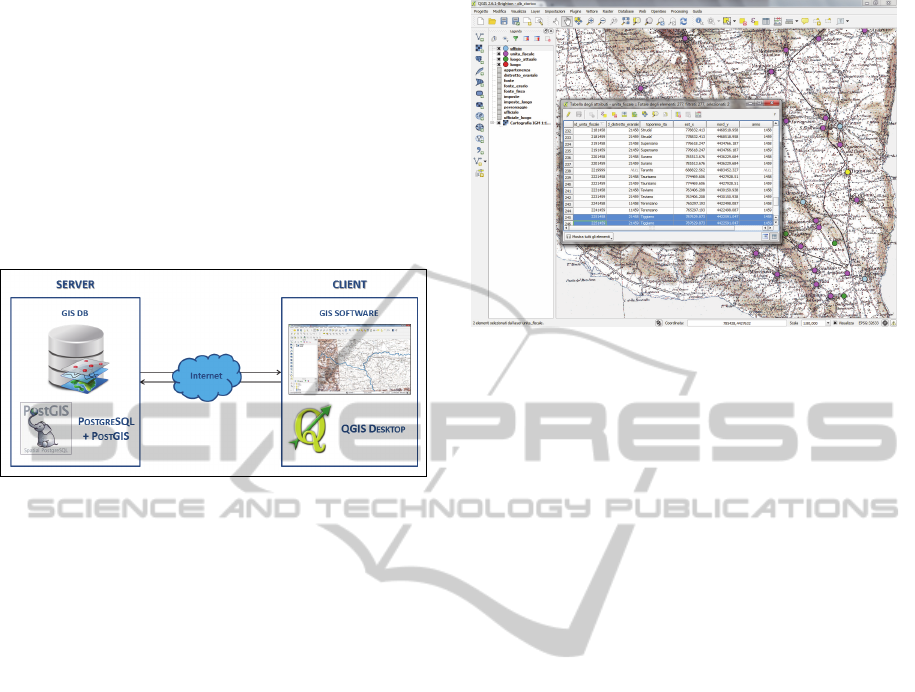
4.2 Historical Geo-resources Sharing
through the Web
This new solution presents an architecture (shown in
Figure 4) that is much simpler than a WebGIS
architecture: in this case only the GIS database is
stored into the Server; the Client is composed only
of a GIS software, QGIS Desktop, that natively
supports the connection with a PostgreSQL database
through the Internet.
FromMedievalDatatoGeo-resourcesontheWeb-AnInnovativeWayofMappingHistory
9
This configuration solves the problem related to
the Medieval WebGIS, regarding the connection
between attribute tables and cartographic
representation, which is now implemented.
Furthermore a GIS Desktop software offers many
tools that are not available in a WebGIS
architecture; finally QGIS Desktop is an open source
software that does not require licensing costs and in
recent years is catching up with commercial
software like ArcGIS from the point of view of
completeness and performances.
Figure 4: Client-Server architecture for Medieval
Geo-resources sharing through the Web.
The main problem that remains in this approach
is that the relationships implemented into the
database are not recognized by QGIS, so when the
connection with the DBMS is realized, the entities
imported into QGIS, shown as layers or attribute
tables, are not associated through relationships.
One possible solution is the one implemented the
WebGIS: the creation of views into the database,
that contain the information stored in two or more
entities. The main disadvantage of this solution is
related to the increasing in number of the attributes
contained in a single table, which makes the
consultation of data much more difficult and less
intuitive (if all the relationships in the database
would be implemented, the outcoming view should
become equal to the huge Excel table resulting from
the first phase of the project).
Another solution is being investigated at this
moment, since it could prove to be more
advantageous: namely, to exploit the possibility of
creating some scripts that can work into the QGIS
environment and that allow the software to take into
account the relationships among entities established
in the database.
The entities imported into QGIS from the
Historical Database and one cartographic
representation of the data are shown in Figure 5.
They are overlaid onto a basemap of the Italian
Military Geographic Institute (IGM) made available
as WMS service on the Italian National Geoportal.
Figure 5: The Historical Database imported into QGIS.
5 EXPECTED OUTCOME
The approach presented in this paper has the final
objective to import an Historical Medieval database
into a GIS environment and to implement it in all its
potentiality and completeness (all the entities related
between each other, as represented in the ERD
design). The goal is to supply Historians with an
instrument that makes it possible to realize complex
queries on the Historical data and to show the
outcome of spatial queries on maps.
The System will be accessible mainly by experts
in the field of Medieval research, who will be
provided with suitable tools to easily integrate and
edit data in the database according to their
requirements. The results, in the form of an
Historical Atlas containing selected data and maps,
will be open to a larger community through the
Web.
This type of technology is certainly useful for
improving the ability to deeply analyse Historical
sources and to extract information from them to
support research methods in the field of Medieval
History. Furthermore, even though the GIS will not
be on the Web as a WebGIS, geodata will be stored
on a server and published on a Website, so the data
sharing features of the system will be in any case
maintained with improved performances.
The proposal of this research to exploit the GIS
environment in Historians work can be considered
innovative, particularly for the structuring of a
relational database containing information dating
back to the Medieval period, and for the use of GIS
and Web technologies for History data sharing
through the Internet.
GISTAM2015-DoctoralConsortium
10

6 STAGE OF THE RESEARCH
Currently the research is focused on finding the best
solution to realize a complete and useful Historical
GIS, from the point of view of the database
capacities. At the moment the final part of the study
is in a preliminary phase, to understand how to
realize scripts to import the database relationships
into QGIS.
In any case the possibility to explore any other
way to solve the problem is not yet precluded, also
considering that GIS technologies are continuously
improving, making new solutions available at a very
fast rate.
REFERENCES
Ardissone, P., Rinaudo F., 2005. A GIS for the
Management of Historical and Archaeological Data. In
Proceeding of the CIPA 2005 XX International
Symposium. Torino.
Baiocchi, V., Lelo, K., 2002. Confronto di cartografie
storiche con cartografie attuali per l’area del centro
storico di Roma. In Atti della VI Conferenza Nazionale
ASITA. Perugia.
Balletti, C., 2000. Analytical and Quantitative Methods for
the Analysis of the Geometrical Content of Historical
Cartography. In International Archives of
Photogrammetry and Remote Sensing, vol. XXXIII,
part B5. Amsterdam.
Balletti, C., 2006. Digital elaborations for cartographic
reconstruction: the territorial transformations of
Venice Harbours in historical maps. e-Perimetron,
Autumn 2006, 1, 4: 274-286.
Balletti, C., Guerra, F., Monti, C., 2000. Analytical
Methods and New Technologies for Geometrical
Analysis and Georeferenced Visualization of
Historical Maps. In International Archives of
Photogrammetry and Remote Sensing, vol. XXXII, part
6W8/1, ISPRS WG VI/3 and IV/3, Bridging the gap.
Lubiana.
Barzaghi, R., Carrion, D., 2011. Il GIS come strumento di
ricerca storica: il contributo della cartografia. Ricerche
storiche, anno XLI, n. 1, gennaio-aprile 2011: 45-60.
Berman, L. M., 2005. Boundaries or Networks in
Historical GIS: Concepts of Measuring Space and
Administrative Geography in Chinese History.
Historical Geography, vol. 33, Special issue:
Emerging trends in Historical GIS. Baton Rouge.
Black, J., 2003. Mapping the Past: Historical Atlases.
Orbis, 47: 277-293.
Boonstra, O., Collenteur, G., van Elderen, B., eds, 1995.
Structures and Contingencies in Computerized
Historical Research. In Proceedings of the IX
International Conference of the Association for
History and Computing. Nijmegen, 1994 (Hilversum,
1995).
Brovelli, M. A., Minghini, M., Giori, G., Beretta, M.,
2012. Web Geoservices and Ancient Cadastral Maps:
The Web C.A.R.T.E. Project. Transactions in GIS 16:
125-142.
Carrion, D., Migliaccio, F., 2009. Il principato di Taranto
in un GIS: problemi e potenzialità. In I domini del
principe di Taranto in età orsiniana (1399-1463).
Somaini, F. and Vetere, B. eds, Congedo Editore: 37-
60.
Carrion, D., Migliaccio, F., Minini, G., Zambrano, C.,
2015, in press. From historical documents to GIS: A
spatial database for medieval fiscal data in Southern
Italy, Historical Methods: A Journal of Quantitative
and Interdisciplinary History.
De Moor, M., Wiedemann, T., 2001. Reconstructing
territorial units and hierarchies: a belgian example.
History & Computing 13: 71-97.
Fitch, C. A., Ruggles, S., 2003. Building the National
Historical Geographic Information System. Historical
Methods: A Journal of Quantitative and
Interdisciplinary History 36: 41-51.
Gregory, I. N., 2002. A Place in History: A Guide to
Using GIS in Historical Research. Oxbow. Oxford.
Gregory, I. N., Bennet, C., Gilham, V. L., Southall, H. R.,
2002. The Great Britain Historical GIS: From Maps to
Changing Human Geography. The Cartographic
Journal.
Gregory, I., Healey, R., 2007. Historical GIS: Structuring,
mapping and analysing geographies of the past.
Progress in Human Geography 31: 638-653.
Mangia, M. A., 2013. La diocesi di Benevento nel
Quaternus decimarum del 1478: un contributo alla
realizzazione di un GIS di cartografia storica sul
Mezzogiorno bassomedievale. Master’s degree thesis,
Università del Salento.
Pawson, E., 1997. The New Zealand Historical Atlas.
Journal of Historical Geography 23: 496-499.
Pizzuto, S., 2009. Il Quaternus declaracionum di
Francesco de Agello (1450-1461). Un contributo allo
studio della geografia politica del Principato di
Taranto in età orsinana. In I domini del principe di
Taranto in età orsiniana (1399-1463). Somaini, F. and
Vetere, B. eds, Congedo Editore: 61-76.
Schlichting, K., 2008. Historical GIS: New Ways of Doing
History. Historical Methods 41: 191-196.
Zambrano, C., 2013. Progettazione e realizzazione del
sistema informativo territoriale “Geografie dell’Italia
Medievale (XIII – XV sec.)”. Ph.D. thesis, Politecnico
di Milano.
FromMedievalDatatoGeo-resourcesontheWeb-AnInnovativeWayofMappingHistory
11
