
A Wireless Sensor Network System
For Monitoring Trees’ Health Related Parameters in a University Campus
Luis Eduardo Pérez, Jorge Arturo Pardiñas-Mir, Omar Guerra, Javier de la Mora, Mauricio Pimienta,
Nestor Hernández and Manuel de Atocha Lopez
Electronics, Systems and Informatics, ITESO University, Periférico Sur 8585, 45604, Tlaquepaque, Mexico
Keywords: Wireless Sensor Networks, Web Services, Mobile Application.
Abstract: This paper presents an experimental Wireless Sensors Network system which aims to contribute to the
transformation of a university campus into a living lab to experiment with applications in the context of a
smart city. The system acquires environmental data related to the campus trees’ health, stores it in a server
to be analysed and makes it available to be displayed in a mobile application. Details are given to the design
and results of the server’s system and the MobApp.
1 INTRODUCTION
Our cities around the world are having currently a
significant growth, the UN estimates that by year
2050 70% of the population will live in cities (UN,
2010). This will create significant pressure for cities
to efficiently provide services for the population:
water, energy, transportation, health care, education
and security. Cities must become "smart" (Naphade
et al., 2011) in how they manage their infrastructure
and resources to meet current and future needs.
The intelligence of cities is on the basis of
innovation and new working practices, primarily, on
the use of communication technologies and
information as a mean to achieve it. In this aspect,
the concept of all objects connected via internet
forms a technological basis for collecting
information from the city centers: water meters,
electricity meters, traffic sensors, parking meters,
temperature sensors, GPS devices, mobile phones,
etc. It is the concept called "Internet of Things" (or
IoT) (Foschini et al., 2011).
One of the key components of IoT is
undoubtedly wireless sensor networks of different
types (architecture, size, extent) which connect to
the Internet. They are able to provide the collected
information facing several challenges such as
holding systems’ owners and operational standards
that are not open, which prevents, for example, the
integration with other systems (Jiang et al., 2013).
We are developing a campus wide wireless
sensor network as an experimental platform to
research and implement solutions oriented to turn
the university campus into an intelligent community,
being a living lab to experiment with applications
that could be adapted in the context of a smart city.
One of such applications that we are using at the
same time as a demo of a living lab possibilities, as a
real laboratory for student lab work and research and
as a running service, is a system conceived to
collect, store and present information concerning the
health of the trees in the campus. This paper focuses
on the development of the computing and
information process stage of the application, leaving
for a later publication the details of the platform
hardware.
The system aims to collect information from a
network of wireless sensors making it available for
immediate query through a mobile application. At
the same time the information is stored in a web
server for later analysis. This represents the
integration of various emerging technologies; first of
all, the network of sensors reads temperature and
humidity data, secondly, the data is stored and
managed in a database on a server and, finally,
through a web service, a mobile application requests
the data from the server and presents it graphically.
It is expected that lab work from students and
research could be driven in these subjects under real
conditions. Some studies (Dospinescu, 2013),
(Moreira, 2011), (Choi, 2013), (Koo, 2011) which
refer to using a mechanism for sending / receiving
information through the use of web services using
REST and HTTP, are similar to our purpose.
42
Pérez L., Pardiñas-Mir J., Guerra O., de la Mora J., Pimienta M., Hernández N. and Lopez M..
A Wireless Sensor Network System - For Monitoring Trees’ Health Related Parameters in a University Campus.
DOI: 10.5220/0005546600420047
In Proceedings of the 12th International Conference on Wireless Information Networks and Systems (WINSYS-2015), pages 42-47
ISBN: 978-989-758-119-9
Copyright
c
2015 SCITEPRESS (Science and Technology Publications, Lda.)
2 ELEMENTS OF THE SYSTEM
The university campus to be monitored has a surface
of over 41 hectares where 22 hectares correspond to
green areas. Here there are over three thousand trees
of over 280 different species. In order to maintain in
good health this valuable natural resource of the
university it is necessary to periodically monitor
some physical parameters that bring information
related to the conditions at which trees become
susceptible to contracting a disease or pest.
According to the requirements provided by the
office in charge of the gardens of the campus, the
parameters to be sensed in a first stage, are the
moisture and temperature of soil and the temperature
of trees.
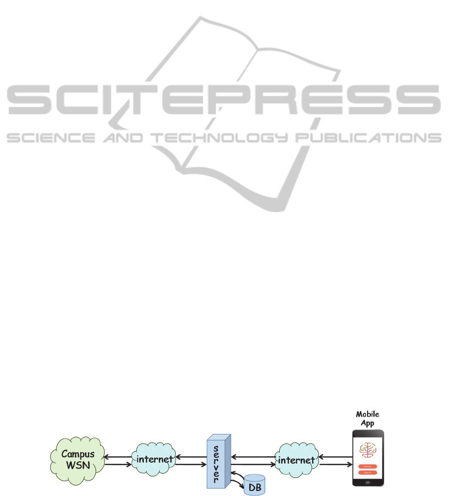
The system that we are developing, Figure 1, has
already been concept tested in a first stage. It is
based on a wireless network of sensors distributed
all over the campus to collect the physical
parameters from the trees’ environment. This data is
transmitted to a station (server) in charge of storing
it and providing it to the users for its analysis. The
information is then looked up and displayed through
a mobile application via internet. An additional
feature is to show the route to go from any location
in the campus to a specific tree.
2.1 The Campus Wide Wireless Sensor
Network
At the base of the system there´s an experimental
wireless sensor network consisting of several sensor
nodes (SN). Each sensor node has the possibility of
sensing the values corresponding to the soil
moisture, humidity sensor (HS), and temperature of
soil (ST), and the temperature of trees (TT).
According to the requirements, some samples of
these values are sensed in a specific gardens’ area,
meaning that there’s no need of having a sensor
node for each and every tree of the campus.
The sensors are grouped into areas of trees
concentration and they communicate wirelessly to a
router node (RN). The router, one for each area,
manages the communication between sensors and a
coordinator node (CN) in charge of the whole
network. This coordinator node has also the
possibility of performing as a gateway to let the
network communicate with the system’s server by
internet. Figure 2 shows, as an example, a tested
WSN architecture comprising a coordinator, 3
routers and 3 sensor nodes per router. Each router
covers a specific tree-covered zone of the campus
where the monitoring is required. This architecture
is changing as we make the network grows and test
for the best results.
The WSN uses Zigbee technology to
communicate wirelessly between nodes while the
coordinator, at present, is connected to the internet
through an Ethernet port. We use XBee ZB RF
Modules from Digi International working at the ISM
2.4 GHz band. The low version is used in the sensor
nodes, running on batteries, while the PRO version
(more power) is used for the Router and the
Coordinator nodes running on electric power. A
more detailed description of the WSN is planned in a
coming publication.
2.2 The Server
The main functions of the systems’ server are: to
communicate with the WSN, to interact with the
mobile application (MobApp), and to manage the
database and to calculate the route to go from any
location in the campus to a specific tree.
The communication with the WSN is made with
the networks’ coordinator, through a TCP/IP
connection. It sends the required commands to read
the sensors’ values.
The interaction between server and the mobile
application uses web services based on REST and
SOAP. Here we are using SOAP as an educative
strategy for the students participating in the project.
The MobApp sends requests to the server for tree
information: species, georeference, planting date,
height, and health related variables (tree’s
temperature, soil’s temperature and soil’s moisture).
The sever has the possibility to respond with a XML
or JSON format file.
Figure 1: Components of the system.
AWirelessSensorNetworkSystem-ForMonitoringTrees'HealthRelatedParametersinaUniversityCampus
43
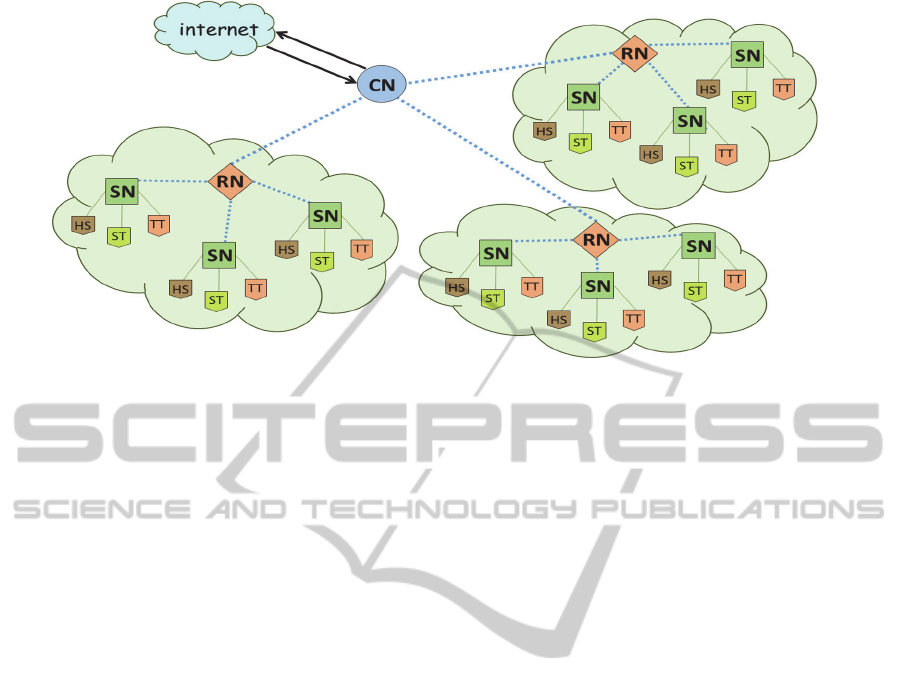
Figure 2: The Wireless Sensor Network Architecture.
The data base design takes into account an
existing old database of trees in the campus, still at
work, in order to normalize it and assure data
consistency. This data was linked to the sensors’
positions. In addition, a small program was made to
have the possibility of managing new entries and
relations between trees and sensors.
Due to the fact that main maps’ providers don’t
take into account the route path computation into
private spaces, like the University campus in this
case, it was necessary to develop in the server a web
service to compute the route to go from any point in
the campus to a targeted tree. For this means it was
necessary to consider the internal map of the
campus.
2.3 The Mobile Application
The Mobile Application was developed at the same
time for the iOS and Android platforms. Both of
them were designed with the same looking and
functionalities. The design process includes the
application requirements determination, the design
concept definition, and the user experience (UX) and
the user interface (UI) tests.
The entry data to the application is either the
number of a tree (all trees in the campus have a plate
with a number) or the name of a tree species. The
MobApp establishes an HTTP connection to send
the identifier. The server responds with the related
information from the database which is formatted in
one of two requested formats: XML or JSON. The
MobApp displays this information in a graphical
way. In the case of an inquiry using the tree’s
identifier the response includes all the tree’s
characteristics. For the case of an inquiry with a tree
species’ name the response is the map of the campus
showing the positions of all trees belonging to that
species. These results can be filtered for different
zones of the campus. Each tag on the map,
representing one tree, is sensitive to show the
information of that specific tree.
In the case of a route inquiry to go from any
location in the campus to a specific tree, the
MobApp sends to the server the user’s location and
the target tree’s location. The algorithm in the server
searches for the shortest route from the user to the
tree and sends the location of points of a valid path
to the MobApp in order to be displayed on the
campus map.
3 IMPLEMENTATION AND
RESULTS
The center of the system is a Linux server which
communicates with the WSN coordinator through a
TCP/IP connection. The communication program is
coded in Python, performing the necessary
commands to interact with the WSN protocol: IEEE
802.15.4. At this first stage of development we
acquire only the temperature and moisture of soil;
tree’s temperature as well as other environmental
variables will be added in a next stage.
The database was developed using MySQL
technology. It manages four kinds of information,
each one defined in a data table: information related
to the tree (rssy_arboles_inventario), information
related to the tree species
(rssy_arboles_taxnonomias), information related to
the garden zones (rssy_arboles_jardines) and
WINSYS2015-InternationalConferenceonWirelessInformationNetworksandSystems
44
information related to the sensors
(rssy_arboles_inspeccion).
The web services are accessed through an API
running in the server that was developed in PHP.
This API lets the server receive a request for a
specific tree or for a tree’s species. In the case of the
tree, the syntax needed to be used by the MobApp to
get the information in XML format is:
http://papvidadigital.com/risi_app/?
nid=ID
where ID is the tree identifier, while for getting the
JSON format, for example, the tree with identifier
99, is:
http://papvidadigital.com/risi_app/?
nid=99&format=json
The response received by the MobApp from the
server includes the whole information related to the
tree: identifier, species, planting date, diameter,
height, estimated health status (according to
temperature and moisture data), latitude, longitude,
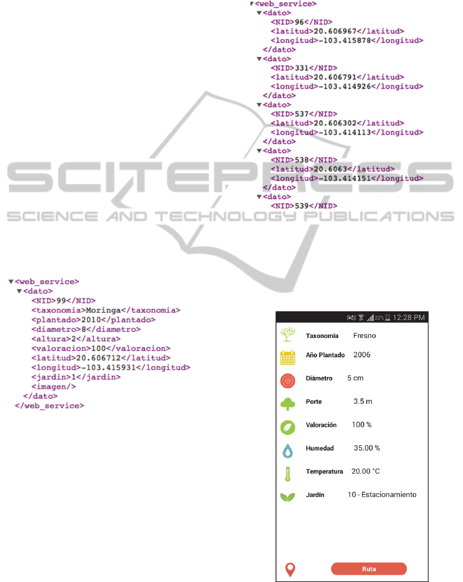
garden’s zone, and image. Figure 3 shows the page
of the MobApp which displays the tree’s
information.
An example of a response for both XML and
JSON format are:
{“dato”:[{“dato”:{“NID”:“99”,”taxono
mia”:“Moringa”,“plantado”:“2010”,”di
ámetro”:”8,”altura”:”2”,”valoración”
:”100”,”latitud”:”20.606712”,”longit
ud”:”103.415931”,”jardin”:”1”,”imag
en”:””}}]}
In the case of a species request, the inquiry is
constructed from the tree identifier and the name of
the species, as shown here for both formats:
http://papvidadigital.com/risi_app/?
id_taxonomia=ID
http://papvidadigital.com/risi_app/?
id_taxonomia=2&format=json
The response, as said before, is the location of
every tree belonging to that species, as shown here
for the XML format case:
The process of showing the route from the user’s
location to the target tree was divided in two: first,
the path is calculated in the server after an inquiry
from the MobApp, and then, the server returns the
latitude and longitude corresponding to all points of
the path. Second, the MobApp takes these points and
shows them graphically on the campus map.
Figure 3: Mobile display of tree’s information.
AWirelessSensorNetworkSystem-ForMonitoringTrees'HealthRelatedParametersinaUniversityCampus
45
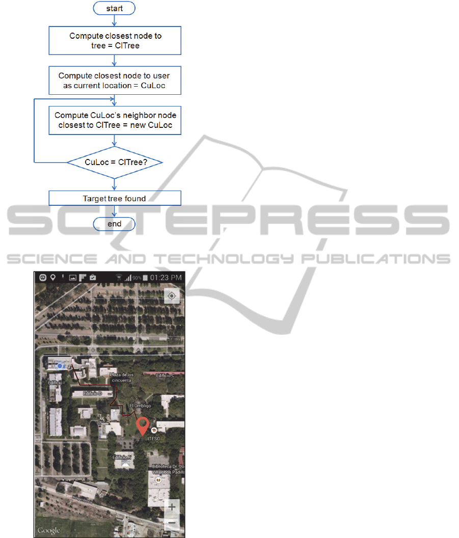
Figure 4: Flow diagram to compute the route from the user
to a target tree.
Figure 5: Display of the result of a route computing.
We programmed a simple algorithm for
calculating a path from the user to the target tree
following the possible real routes of the campus. For
this aim it was necessary to acquire and store in
advance the georeferenced data related to the
location points of campus’ valid walking routes. The
algorithm corresponding to the route computing is
shown in figure 4 while a display of a route result is
shown in figure 5. At this moment, the algorithm is
not yet optimal for analyzing all possible routes and
be able to know which the shortest one is.
4 CONCLUSIONS
We have presented a complete system consisting of
a wireless sensor network, a server provider of web
services, and a mobile application, that provides
information of some environmental parameters
related to the tree’s health in a university campus.
We have described details concerning the design of
the server and the MobApp based on the paradigm
of web services using REST and SOAP.
The project has a double objective. First, to
develop a system that provides a service for the
university. Second, to allow to experience with real
applications related to wireless sensor networks, web
services, and mobile applications. In this context, the
future work is first, to optimize the hardware and
management of the wireless network, second, to link
to the system a culture house belonging to the
university which is located at the center of the city
and, third, to develop an application that lets the
university’s office in charge of the campus’ gardens
to process and analyze the information.
All of this contributes to transform the campus
into a living lab for experimenting with applications
that could be in turn adapted in the context of a
smart city.
REFERENCES
Choi, M., Jeong, Y., Park, J., 2013. Improving
Performance through REST Open API Grouping for
Wireless Sensor Network. In International Journal of
Distributed Sensor Networks Volume 2013, Article ID
958241. http://dx.doi.org/10.1155/2013/958241
Dospinescu, O., and Perca, M., 2013. Web Services in
Mobile Applications. In Informatica Economica, vol.
17. DOI:10.12948/issn1431305/17.2.2013.02
Foschini, L.; Taleb, T.; Corradi, A.; Bottazzi, D., 2011.
M2M-based metropolitan platform for IMS-enabled
road traffic management in IoT. In Communications
Magazine, IEEE , vol.49, no.11, pp.50,57, November
2011. doi: 10.1109/MCOM.2011.6069709
Koo, B., Han, K., James, J., Shon, T., 2011. Design and
implementation of a wireless sensor network
architecture using smart mobile devices. In
Telecommun Syst (2013) 52:2311–2320. DOI
10.1007/s11235-011-9535-z
WINSYS2015-InternationalConferenceonWirelessInformationNetworksandSystems
46

Jiang, Y., Zhang, L., and Wang, L., 2013. Wireless Sensor
Networks and the Internet of Things. In International
Journal of Distributed Sensor Networks, vol. 2013,
Article ID 589750. doi:10.1155/2013/589750
Moreira, N., Venda, M., Silva, C., Marcelino, L., Pereira,
A., 2011. @Sensor – Mobile Application to Monitor a
WSN. In CISTI (Iberian Conference on Information
Systems & Technologies / Conferência Ibérica de
Sistemas e Tecnologias de Informação) Proceedings,
July.2011.
Naphade, M.; Banavar, G.; Harrison, C.; Paraszczak, J.;
Morris, R., 2011. Smarter Cities and Their Innovation
Challenges. In Computer , vol.44, no.6, pp.32,39, June
2011. doi: 10.1109/MC.2011.187
United Nations, 2010. World Urbanization Prospects: The
2009 Revision—Highlights, 2010; http://esa.un.org/
unpd/wup/doc_highlights.htm.
AWirelessSensorNetworkSystem-ForMonitoringTrees'HealthRelatedParametersinaUniversityCampus
47
