
A Service-oriented Architecture for GIS Applications
Atif Naseer, Hossam I. Aldoobi and Basem Y. Alkazemi
GIS Technology Innovation Center, Umm Al-Qura University, Makkah, Saudi Arabia
Keywords: Geographical Information System, Service Oriented Architecture (SOA), Software Architecture.
Abstract: Many Geographic Information Systems (GIS) are currently built according to the N-Tier architectural style.
Despite the advantages of this style in terms of simplicity for the GIS business domain, it lacks many
capabilities related to several key characteristics that might affect reusability and extensibility of GIS systems.
Service-oriented architecture (SOA), on the other hand, can better serve the continual changing nature of GIS
business requirements by facilitating faster and more reliable implementation of business requirements. This
paper analyzes the current state of one of the commonly used GIS applications, namely GRASS, to define a
potential road map for re-factoring its architecture to match our proposed SOA style in this paper.
1 INTRODUCTION
Geographic Information Systems (GIS) are widely
used by many users nowadays. With the rapid
development of technology, GIS systems are now
used as a daily tool by many people. However, most
people face a lot of difficulties in designing and
implementing GIS systems. Some of these difficulties
relate to GIS data, GIS services, GIS system
development and interfacing of GIS systems with
other applications. GIS introduces some methods and
services to visualize, analyze and manipulate GIS
data. Different organizations develop their own data
model and structure.
Nowadays many GIS systems are used to achieve
the goals of their users. Most of the systems follow
N-Tier architecture for GIS application development.
There are several advantages to N-Tier architecture,
the main advantage being that all the business logic is
defined once in a business, and the presentation layer
uses that logic to represent information. Any changes
in one layer can be easily available in all the
applications. Despite the advantages of this style in
terms of simplicity for the GIS business domain, it
lacks many capabilities related to several key
characteristics that might affect reusability and
extensibility of GIS systems. Also it is more difficult
to set up and maintain the physical layers as it results
in high communications overheads as well.
SOA is a software engineering methodology for
constructing a distributed software system. The SOA-
based model can better serve the continual changing
nature of GIS business requirements. In this paper we
analyze the current state of one of the commonly used
open source GIS software programs, GRASS.
GRASS is one of the open source tools used for
geospatial data management and analysis, maps
construction and processing, modelling and
visualization of spatial data (GRASS GIS, 2015).
GRASS is used to develop desktop GIS applications.
Most of the vendors describe their GIS system from a
business perspective. They do not describe the
architecture of the system, but only show the
functional aspects of the systems to the users.
Here we discuss an SOA-based model and map
the services of GRASS onto this model. We will
identify the services which are currently not present
in GRASS and try to identify those services and fit
them into appropriate layers of proposed architecture.
The paper is structured as follows. In section 2,
we discuss GIS application architecture in brief. In
section 3, we discuss the Service Oriented
Architecture of software engineering. Section 4
highlights analysis of GIS application architecture. In
section 5 we map the GRASS on Proposed SOA-
based Framework. We discuss future research
directions and conclude the paper in section 6.
151
Naseer A., Aldoobi H. and Alkazemi B..
A Service-oriented Architecture for GIS Applications.
DOI: 10.5220/0005556501510155
In Proceedings of the 10th International Conference on Software Paradigm Trends (ICSOFT-PT-2015), pages 151-155
ISBN: 978-989-758-115-1
Copyright
c
2015 SCITEPRESS (Science and Technology Publications, Lda.)
2 GEOGRAPHIC INFORMATION
SYSTEM APPLICATION
ARCHITECURE
A Geographic Information System (GIS) is a
computer system that has an N-Tier architecture like
most other computer information systems (Jankovic
and Milidragovic, 2013). Most of the systems used
for GIS application development follow the N-Tier
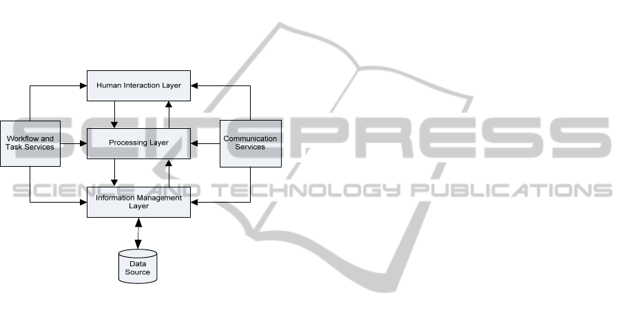
architecture. This architecture is mainly composed of
three layers, namely Human Interaction Layer,
Processing layer and Information Management
Layer, as shown in Figure 1.
Figure 1: Typical N-Tier GIS Architecture.
The main advantage of this n-tier GIS architecture is
that it separates the system functionality into three
different layers, and these functions interact only
through interfaces. The developer can modify the
functionality of any layer with little impact on others.
So this architecture provides flexibility,
maintainability, reusability, scalability and increased
performance. (Luaces, Brisaboa, Paramá and
Viqueirs 2005) presents some special functional
requirements for GIS applications. For example:
The datatypes required to represent geographic
information are different from ordinary
datatypes called Special data types.
Geographic information have different analysis
and visualization procedures.
Geographic information is typically large in
terms of its hierarchical structure.
Geographic information database transactions
are much more complex than a transaction of
standard relational database.
There are two diverse conceptual views of
geographic space i.e. field-based model and
object-based model.
Some of the examples of GIS systems that follow N-
Tier architecture are as follows:
MapWindow GIS is an open source GIS
application and set of programmable mapping
components. These components can be
reprogrammed to perform different tasks. The
MapWindow GIS is built upon Microsoft .NET
technology (MapWindow GIS, 2014). It
provides a human interaction layer to build user
interfaces, it has some processing functions that
can process the data and it also has a data storage
mechanism. So the MapWindow application
includes standard GIS data visualization
features, attribute table editing, shape file
editing and data convertors (MapWindow GIS
Desktop Overview, 2013).
ArcGIS is used for creating and sharing web
maps, and web mapping apps, searching for GIS
content in organizations, creating groups, and
sharing links to GIS apps, maps, and layer
packages (ARCGIS 10.3.1 FOR SERVER,
2015). ArcGIS provides different types of
services like real-time data processing,
querying, visualization and editing.
SEXTANTE is a spatial data processing
framework that is used by Quantum Geographic
Information System (QGIS) for analysis.
SEXTANTE contains many tools like graphical
modeler, command line interface and batch
processing interface. It allows the QGIS
interface to run a large number of analysis
algorithms. (The SEXTANTE framework,
2015).
3 SERVICE-ORIENTED
ARCHITECTURE
Service-oriented architecture (SOA) is a new
development in distributed computing. It allows
software components called “services” to interact
with each other to complete any task. In service-
oriented application, each activity is implemented as
a separate service (Kushwaha, Amundson,
Koutsoukos and Neema, 2007). Many applications
can be created from a composition of these services,
and the services can also be shared among many
applications.
Service-oriented architecture (SOA) has become a
very popular architecture paradigm for designing and
developing a distributed system. According to Bianco
et al. (Phil, Rick and Paulo, 2012), there are many
ICSOFT-PT2015-10thInternationalConferenceonSoftwareParadigmTrends
152
definitions of a service in SOA but none are
universally accepted. A service:
Can be deployed independently.
Is used in the network by name or locator instead
of absolute network address.
Implementation is encapsulated and can only
interact through the interface.
Can be discovered by user through a directory
service.
Is dynamically bound so a user can locate and
bind the service at runtime.
In SOA, the services are interact among themselves
through a standard language called XML. According
to Papazoglou et al. (Papazoglou, 2003), this
architectural approach allows multiple applications
running on different technologies to communicate
with each other. An SOA service is usually a business
function implemented in any language that has a well-
defined interface and is accessed and used by other
components. Papazoglou et al. Papazoglou, 2003)
state that this feature is inherited from the software
engineering concept of modularity, like modules,
objects and components. A service is a complete
business function that is reused by many other
applications.
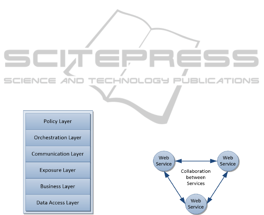
Figure 2: Architecture Layers of SOA-based Framework.
Here we discuss the SOA-based model proposed in a
previous work by Alkazemi (Alkazemi, Baz and
Grami, 2012). This framework functions as an
integration facilitator for applications. It is composed
of six layers. Figure 2 shows the proposed
architecture.
The descriptions of these layers are as follows:
Data Access Layer: This layer provides the database
connectivity service to the application. This layer
hides the underlying database from the application.
Business Layer: This layer is responsible for
executing the basic functionality that represents an
organization’s business needs. This layer provides the
services related to the business layer of any
application. It will be responsible for managing all the
modules and encapsulating them accordingly so that
every module of an application behaves as a
standalone system.
Exposure Layer: This layer is responsible for
exposing the available applications from the
application layers to services (e.g. web services, com
components). All applications are therefore
decoupled from their underlying environment and
made available through the request-response
interaction mode.
Communication Layer: This layer provides the
services related to communication pattern and routing
protocol. It enables service discovery and interaction
which helps applications in establishing
communication. It also defines the policies according
to different standards used in the application. For
example, web services interact by exchanging SOAP
messages over HTTP protocol. So this layer is
responsible in establishing communication between
services. This layer is also referred as Enterprise
Service Bus (ESB) layer.
Orchestration Layer: This layer is responsible for
defining the business process. With the help of this
service system the sequence and dependencies
between all the services required by the application
are established. Figure 3 shows how the web services
collaborate with each other.
Figure 3: Collaboration between services.
Policy Layer: This layer is responsible for defining
the user rights and privileges to access the
application. Any application administration can
define the privileges and policy of the application by
using this service.
AService-orientedArchitectureforGISApplications
153
4 ANALYSIS OF GIS
APPLICATION
ARCHITECTURE
Most GIS applications are built using N-Tier
architecture. There are several advantages and
disadvantages of N-Tier architecture. We proposed an
SOA-based framework in the previous section. There
are several advantages of SOA-based systems. Some
of them are:
The SOA environment is open and
interoperable, as the services are reusable and
have standardized components.
SOA creates an infrastructure for application
development, so an application based on SOA
provides users with only the functionality they
need (Sahin and Gumusay, 2008).
Data is not stored locally for any processing
and is used from various different sources. For
this reason the quality of output is increased.
A system developed using the SOA approach
can be adapted to changing requirements and
technologies. Also these systems are easy to
maintain and are more consistent (Aydin, 2007).
The services in SOA-based architecture are
loosely coupled, which means we can easily
change or update any component without
making changes to other components.
The services in SOA-based architecture are
encapsulated so the user can get the services
without knowing the internal implementation
of the service.
There are numerous characteristics of N-Tier and the
SOA model that make them a successful model for an
application. In this section we make a comparison
between N-Tier and SOA according to the following
characteristics: Language/Technology Dependency,
Extendibility, Modifiability, Data Exchange, System
Table 1: Comparison between N-Tier and SOA model.
Characteristics N-Tier SOA
Language/Techno
-logy Dependency
Dependent
Independent
Extendibility Hard to extend Fully extendible
Modifiability Major changes to
source code
Supports plug and
play effectively
Data Exchange
Internally
Internally/
Externally
Maintenance Affects most of the
system
Only one service is
affected
Separation of
Concerns
Homogeneous Heterogeneous
Coupling Tightly coupled Loosely coupled
Encapsulation Partially
encapsulated
Fully encapsulated
Integration, Maintenance, Separation of Concerns,
Coupling, and Encapsulation.
We have generated a comparison matrix of N-Tier
and the SOA-based model. Table I below presents
this matrix.
5 MAPPING OF GRASS ON
PROPOSED SOA-BASED
FRAMEWORK
In the above section we define the SOA-based
framework with different layers. Each layer provides
a specific service which helps in developing any GIS
application. In this section we discuss how an
application can be built in GRASS GIS using the
above-mentioned SOA-based framework. We try to
map the services provided by GRASS GIS onto each
layer of the proposed SOA-based model.
Data Access Layer: In GRASS GIS, the function
db.connect allows the user to set database connection
parameters. Values are stored in the mapset's VAR
file (GRASS Database Connection, 2013). By adding
this service to GRASS the user can add, access and
retrieve data from any type of database. This layer
provides the compatibility services between DBMS
and GRASS.
Business Layer: GRASS GIS supports lots of
business applications. It can provide a service that
serves different types of businesses related to
archeology, agricultural, geophysics, public health,
remote sensing etc. This layer helps in developing a
component-based GIS using GRASS.
Exposure Layer: To wrap GRASS functionality as a
service, one mandatory requirement is to invoke GIS
functionality by a programmable interface (e.g. shell
scripts or an interface for programming languages).
GRASS has a function “—interface-description” for
process description.
Communication Layer: GRASS uses the Open
Geospatial Consortium (OGC) standards and
protocols for data sharing and processing (Open
Geospatial Consortium, 2015).
(Xueming, Shifeng and Steve, 2004) presented the
inter-object and intra-object communication
mechanism. When a client object requests a method
on a server object, it goes to the Object Request
Broker (ORB). The ORB then invokes the method on
behalf of the client. The ORB takes care of locating
the server object, establishing a connection, invoking
the method, getting the result, and closing the
communication session.
ICSOFT-PT2015-10thInternationalConferenceonSoftwareParadigmTrends
154

Orchestration Layer: GRASS is not an SOA-based
model so it cannot establish the sequence and
dependencies between all the services required by the
application. There should be some wrapper that reads
all the services of GRASS and establishes the
sequence and dependencies of all the services.
Policy Layer: “Free software projects are gaining
interest even in the proprietary GIS industry due to
their stability and the transparent development
process” (Open Source GIS, A GRASS GIS
Approach, 2007). GRASS is a desktop-based
application and provides access to users according to
the policy developed by the system administrator.
One of the main advantages to convert GRASS from
desktop to web-based service is that GRASS will
identify the users from their IP addresses and display
the relevant graphs and information for that user.
6 CONCLUSIONS AND FUTURE
WORK
In this paper we highlight the fact that most systems
follow N-Tier architecture for GIS application
development. Despite the many advantages of N-Tier
architecture, there are lot of shortcomings. We
introduce the SOA-based framework for GIS
application development and discuss how an
application can be built in GRASS GIS using the
proposed SOA-based framework. We try to map the
services provided by GRASS GIS onto each layer of
the proposed SOA-based model.
The next step in this project is to translate the design
of the proposed architecture into a real working
system and conduct a number of experimental works
to generate results from the proposed system. Also we
will develop some other applications from different
domains using the proposed SOA architecture.
ACKNOWLEDGEMENTS
This work was funded by KACST GIS Technology
Innovation Center at Umm Al-Qura University under
grant “GISTIC-13-OP04”.
REFERENCES
GRASS GIS 2015. Available form: <http://en.wikipedia.
org/wiki/GRASS_GIS>. [9 April 2015]
Jankovic Dejan, Milidragovic Radmila, 2013 “Integration
opensource GIS software for improving decision-
making in local community”, Acta Technica
Corvininesis - Bulletin of Engineering. Vol. 6 Issue 4,
p73-76.
Luaces M. R., Brisaboa N. R., Paramá J. R. and Viqueirs J.
R. 2005, “A Generic Framework for GIS Applications.
Web and Wireless Geographical Information Systems”,
3428/2005:p94–109.
MapWindow GIS 2014. Available from: <http://en.
wikipedia.org/wiki MapWindow_GIS> [31 Dec 2014].
MapWindow GIS Desktop Overview, 2013, Available
fromhttp://www.mapwindow.org/apps/wiki/doku.php?
id=mapwindow_4_overview [23 March 2013]
Arcgis 10.3.1 for Server, 2015, Available from:
<http://www.esri.com/library/brochures/pdfs/arcgis-
server-functionality-matrix.pdf>, [May 2015]
The SEXTANTE framework, 2015 Available from:
http://www.sextantegis.com, [23 February 2015]
Kushwaha, M.; Amundson, I.; Koutsoukos, X.; Neema, S.;
Sztipanovits, J, 2007: “OASiS: A Programming
Framework for Service-Oriented Sensor Networks,”
COMSWARE 2007. 2nd International Conference on,
vol., no., pp.18, 7-12 Jan 2007.
Phil Bianco, Rick Kotermansk, Paulo Merson, 2012
“Evaluating a Service- Oriented Architecture”,
Available from: http://www.sei.cmu.edu/reports/
07tr015 .pdf [15 Dec 2012].
Papazoglou MP, 2003 “Service-oriented computing:
concepts, characteristics and directions”. In:
Proceedings 4th international conference on web
information systems engineering.
Alkazemi, Basem Y, Baz Abdullah, Grami Grami M, 2012,
“Refactoring Legacy Software Systems into SOA
Compatible Style to Support e-Business Development
in Enterprise Organizations: The Case of Umm Al-Qura
University’s Systems, International Journal of e-
Education, e-Business, e-Management and e-Learning”
2012, Vol.2(6): 465-472 ISSN: 2010-3654.
Sahin K and Gumusay M. U. 2008: “Service oriented
architecture (SOA) based web services for geographic
information systems”, Paper presented at the XXIst
ISPRS Congress, Available from:
http://www.isprs.org/congresses/beijing2008/proceedi
ngs/2 pdf/5 WG-II-5/03.pdf, 2008.
Aydin G, 2007, “A Service Oriented Architecture for
Geographic Information Systems Supporting Real
Time Data Grids”, Ph.D. Thesis, Indiana University,
IN, USA, pp. 12-47.
GRASS Database Connection, 2013 Available from:
<http://grass.osgeo.org/grass64/manuals/db.Connect
.html> [14 Dec 2013]
Open Geospatial Consortium 2015, Available from:
http://en.wikipedia.org/wiki/Open_Geospatial_
Consortium, [27 April 2015]
Xueming Wu, Shifeng Zhang and Steve Goddard, 2004,
“Development of a Component-based GIS using
GRASS”, Proceedings of the FOSS/GRASS Users
Conference (2004).
Open Source GIS, A GRASS GIS Approach, 2007,
Available from http://www.academia.edu/5753114/
Open Source_ GIS_A. GRASS_GIS_ Aproach_3rd,
[August 2007]
AService-orientedArchitectureforGISApplications
155
