Real-time Local Topic Extraction using Density-based Adaptive
Spatiotemporal Clustering for Enhancing Local Situation Awareness
Tatsuhiro Sakai, Keiichi Tamura, Shota Kotozaki, Tsubasa Hayashida and Hajime Kitakami
Graduate School of Information Sciences, Hiroshima City University, Hiroshima, Japan
Keywords:
Spatiotemporal Analysis, Geotagged Tweets, Local Topic Extraction, Social Data Mining, Big Data Analysis,
Spatiotemporal Clustering.
Abstract:
In the era of big data, we are witnessing the rapid growth of a new type of information source. In particular,
tweets are one of the most widely used microblogging services for situation awareness during emergencies.
In our previous work, we focused on geotagged tweets posted on Twitter that included location information
as well as a time and text message. We previously developed a real-time analysis system using the (ε,τ)-
density-based adaptive spatiotemporal clustering algorithm to analyze local topics and events. The proposed
spatiotemporal analysis system successfully detects emerging bursty areas in which geotagged tweets related
to observed topics are posted actively; however the system is tailor-made and specialized for a particular ob-
served topic, therefore, it cannot identify other topics. To address this issue, we propose a new real-time
spatiotemporal analysis system for enhancing local situation awareness using a density-based adaptive spa-
tiotemporal clustering algorithm. In the proposed system, local bursty keywords are extracted and their bursty
areas are identified. We evaluated the proposed system using actual real world topics related to weather in
Japan. Experimental results show that the proposed system can extract local topics and events.
1 INTRODUCTION
One of the most interesting emerging topics in big
data analysis of social media is that social data posted
on social media can be applied to situation awareness
during real world topics and events (Yin et al., 2012).
In particular, during natural disasters such as earth-
quakes, typhoons, floods, and heavy snow storms,
people actively post messages that mention the situ-
ations they are facing through social media sites. This
trend has been encouraged by the increasing popu-
larity of a new type of data on social media: geo-
annotated social data, which is also referred to as geo-
referenced social data (Naaman, 2011). Moreover, it
creates new technical challenges, such as how to show
where and when events occur. These new techniques
help users to better understand their local situation.
In our previous work we focused on geotagged
tweets posted on Twitter that included location infor-
mation as well as a time and text message. Geotagged
tweets are referred to as spatiotemporal documents
because we can analysis topics and events spatiotem-
porally using them. We proposed a spatiotempo-
ral clustering algorithm called the (ε,τ)-density-based
adaptive spatiotemporal clustering algorithm that al-
lows us to extract spatiotemporal clusters in which
geotagged tweets are actively posted. Moreover, we
developed a real-time analysis system using the (ε,τ)-
density-based adaptive spatiotemporal clustering al-
gorithm to analyze local topics and events. The pro-
posed spatiotemporal analysis system is successful in
detecting emerging bursty areas in which geotagged
tweets related to observed topics are posted actively.
The real-time analysis system proposed in our
previous work allows us to enhance local situation
awareness; however, the system requires the key-
words related to the observed topics to be specified in
advance. If the system is specialized for a particular
observed topic, it cannot identify other topics, even
though some local bursty keywords related to emerg-
ing local topics and events are posted around users.
To address this issue, we propose a new real-time spa-
tiotemporal analysis system for enhancing local situ-
ation awareness. This method is based on a density-
based adaptive spatiotemporal clustering algorithm.
Our new real-time spatiotemporal analysis system
is composed of two techniques: quartile-based out-
lier detection to identify bursty local keywords and
density-based adaptive spatiotemporal clustering to
identify bursty local areas. In our new system, lo-
Sakai, T., Tamura, K., Kotozaki, S., Hayashida, T. and Kitakami, H..
Real-time Local Topic Extraction using Density-based Adaptive Spatiotemporal Clustering for Enhancing Local Situation Awareness.
In Proceedings of the 7th International Joint Conference on Knowledge Discovery, Knowledge Engineering and Knowledge Management (IC3K 2015) - Volume 1: KDIR, pages 203-210
ISBN: 978-989-758-158-8
Copyright
c
2015 by SCITEPRESS – Science and Technology Publications, Lda. All rights reserved
203
cally frequent keywords in geotagged tweets that are
within a particular distance from a user are first ex-
tracted. To determine whether local frequent key-
words are bursty keywords or routine keywords, we
utilize quartile-based outlier detection (Hyndman and
Fan, 1996). Moreover, bursty local areas related to
extracted local bursty keywords are identified using
density-based adaptive spatiotemporal clustering.
The remainders of this paper is organized as fol-
lows. In Section 2, related work is reviewed. In Sec-
tion 3, we propose a new real time spatiotemporal
analysis system. In Section 4, we explain the method
for detecting bursty local keywords. In Section 5,
the (ε,τ)-density-based adaptive spatiotemporal clus-
tering algorithm is described briefly. In Section 6, ex-
perimental results and case studies are reported. In
Section 7, we conclude this paper.
2 RELATED WORK
In the era of big data, social media is expected to
enhance the situation awareness of local topics. In
particular, many researchers focus on natural disas-
ters and have developed awareness systems for nat-
ural disasters such as earthquakes, typhoons, floods,
and diseases (Yin et al., 2012). During natural dis-
asters, users often post text messages through social
media about things that they are witnessing(Hui et al.,
2012), (Kreiner et al., 2013), (Mendoza et al., 2010).
Some of the most successful proposals concern
crisis management systems for earthquakes, floods,
and epidemics. Sakaki et al. (Sakaki et al., 2010)
focused on a method for predicting earthquake epi-
centers by using geotagged tweets regarding earth-
quakes. Avvenuti et al. (Avvenuti et al., 2014) de-
veloped an earthquake alert and report system that can
identify damage in earthquake-affectedareas. Vieweg
et al. (Vieweg et al., 2010) showed that information
related to emergency situations is posted on Twitter
during emergencies such as floods and fires. More-
over, Hwang et al. (Hwang et al., 2013) observed flu
epidemics using a spatiotemporal analysis of social
media geostreams.
Kim et al. (Kim et al., 2011) introduced mTrend,
which constructs and visualizes spatiotemporal topic
trends, referred to as “topic movements.” mTrend is
not a tailor-made system; however, it cannot analyze
bursty areas of local topics and events. Thom et al.
(Thom et al., 2012) presented a system that extracts
anomalies from geolocated Twitter messages and vi-
sualizes them using term interactive clouds. This sys-
tem does not address spatiotemporal analysis. Ku-
mar et al. (Kumar et al., 2014) detected road hazards
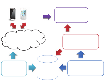
Geotagged
Tweet
Database
Twitter Site
Local Bursty
Keyword Extraction
Manager
newly added
geotagged tweets
Spatial Clustering
Manager
browsing
results
Web Browsers, Android App
Geotagged
Tweet
Crawler
Map-based Web
Interface
local bursty
keywords
bursty areas of
local bursty keywrods
Figure 1: System Overview.
by aggregating hazard-related information posted by
Twitter users. This system is was tailor-made and it
could not extract any hazards other than road-related
topics.
3 SYSTEM OVERVIEW
In this section, we present an overview proposed real-
time spatiotemporal analysis system.
3.1 Sequence Geotagged Tweets
In this study, we focus on geotagged tweets
posted on Twitter. Let gt
i
denote the i-th geo-
tagged tweet in a set of geotagged tweets SGT =
{gt
1
,gt
2
,··· ,gt
t
}; then, gt
i
consists of four items:
gt
i
=< text
i
, pt
i
, pl
i
, photo
i
>, where text
i
is a short
text message, pt
i
is the time when the geotagged tweet
was posted, pl
i
is the location where gt
i
was posted or
is located (i.e., latitude and longitude), and photo
i
is
an attached photo.
3.2 Components
In our system, spatiotemporal clusters of local bursty
keywords related to topics and events are extracted
as bursty areas in real time. Moreover, to visualize
bursty areas, our system provides a map-based user
interface. There are four managers in our system (Fig-
ure 1).
• The Geotagged Tweet Crawler crawls geotagged
tweets from Twitter feed via its Streaming APIs.
Geotagged tweets are stored in a geotagged tweet
database.
• The Local Bursty Keyword Extraction Manager
generates a sequence of geotagged tweets
that are located within r distance of a user.
This sequence is stored in SGT. First, this
manager extracts locally frequent keywords
KDIR 2015 - 7th International Conference on Knowledge Discovery and Information Retrieval
204
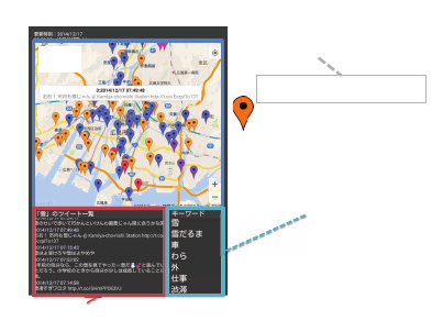
Geotagged Tweets including Focusing Local Bursty Keyword
Map
d T
Ranking of Local
Bursty Keywords
Marker: geotagged tweet
Wow! It is snowing in downtown
Pop-up Window:
geotagged tweet’s message
Figure 2: Interfaces.
LFK
(c)
= {l fk
(c)
1
,l fk
(c)
2
,··· ,l fk
(c)
l
} from
SGT
(c)
, where SGT
(c)
= {gt
k
|gt
k
∈ SGT and pt
k
is
within one hour of the current time}.
It then extract local bursty keywords
LBK
(c)
= {lbk
(c)
1
,lbk
(c)
2
,··· lbk
(c)
m
} from LFK
(c)
using quartile-based outlier detection. The details
of this manager are further explained in Section
4.
• The Spatial Clustering Manager identifies bursty
local areas as spatial clusters using (ε,τ)-density-
based adaptive spatiotemporal clustering for each
local bursty keyword. For each lbk
(c)
i
∈ LBK
(c)
,
(ε,τ)-density-based adaptive spatiotemporal clus-
ters are extracted from SKGT
(key)
= {gt
k
|gt
k
∈
SGT and key∈ text
k
}, where key = lbk
(c)
i
. The de-
tails of this manage are further explained in Sec-
tion 5.
• The Map-based Web Inter face provides the user
interface for browsing extracted spatial clusters.
3.3 User Interface
Figure 2 shows a screen shot of the Map-
based Web Interface which is an Android applica-
tion. There is a map, a list of geotagged tweets of
a current focus local bursty keyword, and a ranking
of local bursty keywords on the Android application
interface. For each local bursty keyword, bursty lo-
cal areas and each geotagged tweets in extracted spa-
tiotemporal clusters within a particular distance from
a user are shown on the Google map. A marker repre-
sents a geotagged tweet and a pop-up window appears
when a user touches the marker.
4 LOCAL BURSTY KEYWORD
EXTRACTION
We extract local bursty keywords from locally fre-
quent keywords that appear frequently in geotagged
tweets near a user. There are many routine keywords
(e.g., greetings) in the set of locally frequent key-
words. Therefore, we have to remove routine key-
words from the set of local bursty keywords. For
example, suppose that a set of frequent keywords is
{“good morning,” “heavy rainfall,” “delay”}. The
keyword “good morning” is a routine keyword that
appears frequently everyday. Therefore, “good morn-
ing” is regarded as a routine keyword.
It is difficult to determine whether a keyword is
a routine keyword or not because the frequencies of
keywords change dynamically depending on time and
location. To determine if locally frequent keywords
are routine keywords, we utilize the quartile-based
outlier detection. The local bursty keyword extraction
comprises two steps: (1) keyword frequency counting
and (2) routine keyword removal.
To count keyword frequency, for each key-
word that appears in the geotagged tweets, the fre-
quency of the keyword is counted per day and
the total is stored in FCD
(key)
. Let FCD
(key)
=
( fcd
(key)
1
, fcd
(key)
2
,··· , fcd
(key)
t
) be a sequence of the
daily frequencies of the keyword key. Moreover, for
each keyword that appears in geotagged tweets, the
frequency of keyword is counted par one hour. Let
FCH
(key)
= ( fch
(key)
1
, fch
(key)
2
,··· , fch
(key)
t
) be a se-
quence of the hourly frequencies of keyword key.
If fch
(key)
c
is larger than a user-given threshold
minf and fch
(key)
c
≥
∑
c−1
k=c−25
fch
(key)
k
/24, the key-
word is a locally frequent keyword. Thus,
LFK
(c)
= {l fk
(c)
i
|
∃gt
(c)
j
∈ SGT
(c)
includes l fk
(c)
i
,
fch
(l fk
(c)
i
)
c
≥ min f and
fch
(l fk
(c)
i
)
c
≥
c−1
∑
k=c−25
fch
(l fk
(c)
i
)
k
/24} (1)
In the second step, for each locally frequent key-
word in LFK
(c)
, locally frequent keyword l fk ∈
LFK
(c)
is removed if it is a routine keyword. Let
the lower quartile, second quartile, and third quar-
tile of FCD
(l fk)
be Q
(l fk)
1
, Q
(l fk)
2
, and Q
(l fk)
3
, respec-
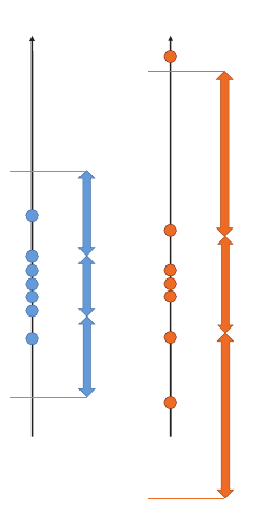
tively. Consider as an example sequence FCD
(l fk
1
)
=
{8,12, 17,10, 11,13, 14}. The second quartile Q
(l fk
1
)
2
is the median of FCD
(l fk
1
)
; therefore Q
(l fk
1
)
2
= 12.
Moreover, Q
(l fk
1
)
1
= 10 and Q
(l fk
1
)
3
= 14.
Real-time Local Topic Extraction using Density-based Adaptive Spatiotemporal Clustering for Enhancing Local Situation Awareness
205
8
17
12
Q
3
=14
Q
1
=10
Q
2
=12
3
29
Q
2
=12
Q
3
=16
Q
1
=8
IQR=4
IQR=8
FCD
(lfk
1
)
FCD
(lfk
2
)
12
Figure 3: Detecting local bursty keywords.
The range |Q
(l fk)
3
− Q
(l fk)
1
| = IQR
(l fk)
is called
the Interquartile Range (IQR). The distribution of
FCD
(l fk)
is used to detect bursty keywords. If dis-
tribution of FCD
(l fk)
is small, this means that l fk
appears constantly in geotagged tweets, but not con-
stantly.
Definition 1 (Local Bursty Keyword). If a locally fre-
quent keyword l fk satisfies at least of the following
conditions, l fk is a bursty local keyword.
(1) ∃ fcd
(l fk)
i
∈ FCD
(l fk)
, fcd
(l fk)
i
− Q
(l fk)
3
>
IQR
(l fk)
× 1.5.
(2) ∃ fcd
(l fk)
i
∈ FCD
(l fk)
, Q
(l fk)
1
− fcd
(l fk)
i
>
IQR
(l fk)
× 1.5
Figure 3 shows an example of local bursty
keyword detection. Consider two example se-
quences FCD
(l fk
1
)
= {8,12, 17,10,11,13,14}, and
FCD
(l fk
2
)
= {3, 12,29, 8,11,13, 16}. For the first se-
quence, as IQR
(l fk
1
)
= 4, there is no data that sat-
isfies definition 1; therefore l fk
1
is a routine key-
word. For the second sequence, IQR
(l fk
2
)
= 8 and
29− 16 > IQR
(l fk
2
)
× 1.5; therefore l fk
2
is not a rou-
tine keyword.
5 ADAPTIVE SPATIOTEMPORAL
CLUSTERING BASED ON
(ε,τ)-DENSITY
Local bursty keywords help us to be aware of what is
happing near users; however, it is difficult to deter-
mine in which places the keywords are occurring.
The Spatial Clustering Manager identifies bursty lo-
cal areas as spatial clusters using (ε,τ)-density-based
adaptive spatiotemporal clustering.
Adaptivespatiotemporal clustering based on (ε,τ)-
density is a natural extension of the density-based
criteria proposed by Ester et al. (Ester et al.,
1996),(Sander et al., 1998). In this section, (ε,τ)-
density-based adaptive spatiotemporal clustering is
explained briefly and we show how to use it to extract
bursty areas of local bursty keywords.
In density-based spatial clustering, for each data
point within a spatial cluster, the neighborhood of a
user-defined radius must contain at least a minimum
number of points; thus, the density in the neighbor-
hood must exceed some predefined threshold. This
density criterion allows us to recognize areas in which
densities are higher than in other areas. However,
it does not consider temporal changes correctly. It
is important to analyze temporal changes to extract
local topics and events to enhance situation aware-
ness in real time. In contrast, the (ε, τ)-density-based
adaptive spatiotemporal clusters cover spatiotemporal
clusters that are both temporally and spatially sepa-
rated from other spatiotemporal clusters.
5.1 Definitions
There are several density-based adaptive spatiotem-
poral criteria that can be used to define (ε,τ)-density-
based adaptive spatiotemporal clusters.
Suppose that a keyword and the set of
geotagged tweets including that keyword are
key and SKGT
(key)
∈ SGT, respectively. Let
kgt
(key)
j
= gt
φ
(key)
( j)
be a keyword-related geo-
tagged tweet that has keyword key included in its
text
φ
(key)
( j)
. A sequence of keyword-related geotagged
tweets is SKGT
(key)
= (kgt
(key)
1
,··· ,kgt
(key)
m
}, where
SKGT
(key)
∈ SGT. Further, function φ
(key)
( j) is an
injective function:
φ
(key)
( j) :
SKGT
(key)
→ SGT; kgt
(key)
j
7→ gt
φ
(key)
( j)
(2)
Definition 2 ((ε,τ)-density-based Neighborhood).
The (ε,τ)-density-based neighborhood of a rele-
vant geotagged tweet kgt
(key)
p
, which is denoted by
KSTN
(ε,τ)
(kgt
(key)
p
), is defined as
KSTN
(ε,τ)
(kgt
(key)
p
) = {kgt
(key)
q
∈ SKGT
(key)
|
dist(kgt
(key)
p
,kgt
(key)
q
) ≤ ε and
iat(kgt
(key)
p
,kgt
(key)
q
) ≤ τ}, (3)
KDIR 2015 - 7th International Conference on Knowledge Discovery and Information Retrieval
206

where the function dist() returns the distance between
kgt
(key)
p
and kgt
(key)
q
, and the function iat() returns the
interarrival time between them.
The local spatiotemporal density of a keyword-
related geotagged tweet kgt
(key)
p
is denoted as
lstd(kgt
(key)
p
). The spatiotemporal space is divided
into several spatiotemporal grids in three-dimensional
space. The number of spatiotemporal grids is div
lng
×
div
lat
× div
time
, where lng, lat and time are longi-
tude, latitude and posted time, respectively. For each
spatiotemporal grid, the number of geotagged tweets
posted in the past is calculated. The degree of lo-
cal spatiotemporal density of a geotagged tweet is the
normalized value of the number of geotagged tweets:
lstd(kgt
(key)
p
) =
stnum(geo
gid(kgt
(key)
p
)) − stnum
min
stnum
max
− stnum
min
, (4)
where stnum(i) returns the number of geotagged
tweets in the i-th grid. Function geo
gid(kgt
(key)
p
) re-
turns the grid ID where kgt
(key)
p
is located. Further-
more, stnum
min
and stnum
max
are the minimum and
maximum values, respectively.
Definition 3 (Adaptive Threshold). The minimum
number of keyword-related geotagged tweets is called
the adaptive threshold ATH, defined as follows.
ATH(kgt
(key)
p
,MinKGT) =
(MinKGT − 1) × lstd(kgt
(key)
p
) + 1, (5)
where the function lstd() returns the degree of local
spatiotemporal density (0 ≤ lstd(kgt
(key)
p
) ≤ 1.0).
A keyword-related geotagged tweet kgt
(key)
p
is called a core-keyword-related geotagged tweet
if there is at least ATH(kgt
(key)
p
,MinKGT) in
KSTN
(ε,τ)
(kgt
(key)
p
) such that (|KSTN
(ε,τ)
(kgt
(key)
p
)|
≥ ATH(kgt
(key)
p
,MinKGT)). Otherwise, kgt
(key)
p
is
called a border-keyword-related geotagged tweet.
Definition 4 ((ε,τ)-density-based Directly Adaptive
Reachable). Suppose that a keyword-related geo-
tagged tweet kgt
(key)
q
is in the (ε,τ)-density-based
neighborhood of kgt
(key)
p
. If |KSTN
(ε,τ)
(kgt
(key)
p
)| ≥
ATH(kgt
(key)
p
,MinKGT), kgt
(key)
q
is (ε,τ)-density-
based directly adaptive reachable from kgt
(key)
p
.
Definition 5 ((ε,τ)-density-based Adaptive
Reachable). Suppose that there is a se-
quence of keyword-related geotagged tweets
(kgt
(key)
p
,kgt
(key)
(p+1)
,··· ,kgt
(key)
(p+l)
) and the (p + i)-th
keyword-related geotagged tweet kgt
(key)
(p+i+1)
is (ε,τ)-
density-based directly adaptive reachable from the
(p + i)-th keyword-related geotagged tweet kgt
(key)
(p+i)
.
The keyword-related geotagged tweet kgt
(key)
(p+l)
is
(ε,τ)-density-based adaptive reachable from kgt
(key)
p
.
Definition 6 ((ε,τ)-density-based Adaptive Con-
nected). Suppose that the keyword-related geotagged
tweets kgt
(key)
p
and kgt
(key)
q
are (ε,τ)-density-based
adaptive reachable from an arbitrary keyword-related
geotagged tweet kgt
(key)
o
. If |KSTN
(ε,τ)
(kgt
(key)
o
)| ≥
ATH(kgt
(key)
o
,MinKGT), kgt
(key)
p
is (ε,τ)-density-
based adaptive connected to kgt
(key)
q
.
5.2 Adaptive Spatiotemporal Clusters
based on (ε,τ)-Density
An (ε,τ)-density-based adaptive spatiotemporal clus-
ter is defined as follows:
Definition 7 ((ε,τ)-density-based adaptive spatiotem-
poral cluster). An (ε,τ)-density-based adaptive spa-
tiotemporal cluster for an keyword key (ASTC
(key)
) in
SKGT
(key)
satisfies the following restrictions:
i1j ∀kgt
(key)
p
, kgt
(key)
q
∈ SKGT
(key)
, if and only if
kgt
(key)
p
∈ ASTC
(key)
, kgt
(key)
q
is (ε,τ)-density-
based adaptive reachable from kgt
(key)
p
, and
kgt
(key)
q
is also in ASTC
(key)
.
i2j ∀kgt
(key)
p
, kgt
(key)
q
∈ ASTC
(key)
, kgt
(key)
p
is (ε,τ)-
density-based adaptive connected to kgt
(key)
q
.
5.3 Algorithm
Algorithm 1 describes the algorithm for (ε,τ)-
density-based adaptive spatiotemporal clustering for
extracting bursty areas of local bursty keyword key.
In this algorithm, for each geotagged tweet gtp in
SKGT
(key)
, the function IsClustered checks whether
gtp is already assigned to a spatiotemporal cluster.
The (ε,τ)-density-based neighborhood of gtp is then
obtained using the function GetNeighborhood. If
gtp is a core keyword-related geotagged tweet, it is
assigned to a new spatiotemporal cluster, and all the
neighbors are queued to Q for further processing.
The processing and assignment of keyword-related
geotagged tweets to the current spatiotemporal clus-
ter continues until the queue is empty. First, the
next keyword-related geotagged tweet is dequeued
from queue Q. If the dequeued keyword-related geo-
tagged tweet is not already assigned to the current
spatiotemporal cluster, it is assigned to the current
Real-time Local Topic Extraction using Density-based Adaptive Spatiotemporal Clustering for Enhancing Local Situation Awareness
207

input : SKGT
(key)
- a set of geotagged tweet including keyword key, ε - neighborhood radius, τ -
interarrival time, MinKGT is threshold value
output: STC
(key)
- set of spatiotemporal clusters
cid ← 1;
STC
(key)
← φ;
for i ← 1 to |SKGT
(key)
| do
gtp ← gt
(key)
i
∈ SKGT
(key)
;
if IsClustered
(
gtp
)
== false then
N ← GetNeighborhood
(
gtp,ε,τ
)
;
if |N| ≥ ATH(gtp, MinKGT) then
stc
(key)
cid
←MakeNewCluster
(
cid,gtp
)
;
cid ← cid + 1;
EnQueue
(
Q,N
)
;
while Q is not empty do
gtq ← DeQueue
(
Q
)
;
stc
(key)
cid
← stc
(key)
cid
∪ gtq;
N ← GetNeighborhood
(
gtq,ε,τ
)
;
if |N| ≥ ATH(gtp,MinKGT) then
EnNniqueQueue
(
Q,N
)
;
end
end
STC
(key)
← STC
(key)
∪ stc
(key)
cid
;
end
end
end
return STC
(key)
;
Algorithm 1: (ε, τ)-density-based adaptive spatiotemporal clustering algorithm.
spatiotemporal cluster. If the dequeued keyword-
related geotagged tweet gtq is a core keyword-
related geotagged tweet, the keyword-related geo-
tagged tweets in the (ε,τ)-density-based neighbor-
hood of gtq are then queued in queue Q using the
function EnNniqueQueue, which places the input
keyword-related geotagged tweets into queue Q if
they are not already in it Q.
6 EXPERIMENTS
We implemented our proposed system and evaluated
it.
6.1 Experiment Setup
We evaluated our proposed system by a case study.
The parameters in the experiments were set as fol-
lows: ε is 5km, τ is 3600sec, and MinKGT is 5.
Moreover, the user location was set to (34.578618,
132.796105). In the experiments, we used geotagged
tweets that were located within 70 km of the user. The
user-given threshold minf is 5.
In the (ε,τ)-density-based adaptive spatiotempo-
ral cluster, local spatiotemporal densities are required.
To calculate local spatiotemporal densities, we used
3,301,605geotagged tweets from December 13 to De-
cember 23, 2013 and counted in each spatiotemporal
grids. We considered the spatiotemporal space for lo-
cal spatiotemporal densities, which is a rectangle con-
sisted of the westernmost point (24.4494, 122.93361)
and the northernmost point (45.5572, 148.752) of
Japan. This rectangle was equally divided into several
spatiotemporal grids of div
lng
= 1,000, div
lat
= 1,000
and div
time
= 24.
6.2 Case Studies
In this experiment, we confirmed our new system
could identify two local topics related to natural dis-
asters. The first local topic is heavy snowfall on De-
cember 17, 2014. A explosive cyclogenesis called
a “bomb” cyclone hit the region of Japan. This ex-
plosive cyclogenesis brought heavy snowfall in Hi-
KDIR 2015 - 7th International Conference on Knowledge Discovery and Information Retrieval
208
Wow! It’s snowing in downtown
Figure 4: Case-1.
Macdonald in Yume Town can
not serve hamburgers because of the power frailer.
They game a refund.
Figure 5: Case-2.
roshima, which is user’s location. Figure 4 shows a
screen shot of the Web-based interfaces on the An-
droid application. The locally bursty keyword include
“snow,” “snow man” and “traffic jam.” These key-
words are related to the snowfall. In the Android ap-
plication, attached photos can be opened. Figure 4
also shows a attached photo. If we look at this photo,
we can be aware of the snowfall in downtown.
The second local topic is a power failure. Figure
5 shows a screen shot of the Web-based interfaces on
the Android application. The power failure occurred
in Hiroshima due to lightning strikes around 13:15
p.m. on February 12, 2015 (JST). Our system could
detect this local topic in real time. The locally bursty
keywords include “lightning” and “power failure.”
7 CONCLUSIONS
In this paper, we proposed a new real-time spatiotem-
poral analysis system for enhancing local situation
awareness using density-based adaptive spatiotempo-
ral clustering. In the proposed system, local bursty
keywordsare extracted and their bursty areas areiden-
tified. In our new system, locally frequent keywords
in geotagged tweets within a particular distance from
a user are first extracted. To determine whether lo-
cally frequent keywords are bursty keywords or rou-
tine keywords, we utilize quartile-based outlier detec-
tion. Moreover, bursty local areas related to extracted
local bursty keywords are identified using density-
based adaptive spatiotemporal clustering. We evalu-
ated the proposed system using actual real-world top-
ics related to weather in Japan. Experimental results
Real-time Local Topic Extraction using Density-based Adaptive Spatiotemporal Clustering for Enhancing Local Situation Awareness
209
showed that the proposed system could extract local
topics and events. In our future work, we are go-
ing to evaluate using variety types of local topics and
events. Moreover, some local bursty keywords are re-
lated each other; however, the proposed system shows
these keywords individually. We are developing sum-
marizing method for local bursty keywords.
ACKNOWLEDGEMENTS
This work was supported by JSPS KAKENHI Grant
Number 26330139 and Hiroshima City University
Grant for Special Academic Research (General Stud-
ies).
REFERENCES
Avvenuti, M., Cresci, S., Marchetti, A., Meletti, C., and
Tesconi, M. (2014). Ears (earthquake alert and re-
port system): A real time decision support system
for earthquake crisis management. In Proceedings of
the 20th ACM SIGKDD International Conference on
Knowledge Discovery and Data Mining, pages 1749–
1758.
Ester, M., Kriegel, H.-P., Sander, J., and Xu, X. (1996).
A density-based algorithm for discovering clusters in
large spatial databases with noise. In Second Interna-
tional Conference on Knowledge Discovery and Data
Mining, pages 226–231.
Hui, C., Tyshchuk, Y., Wallace, W. A., Magdon-Ismail, M.,
and Goldberg, M. (2012). Information cascades in so-
cial media in response to acrisis: A preliminary model
and a case study. In Proceedings of the 21st Interna-
tional Conference Companion on WWW, pages 653–
656.
Hwang, M.-H., Wang, S., Cao, G., Padmanabhan, A., and
Zhang, Z. (2013). Spatiotemporal transformation of
social media geostreams: A case study of twitter for
flu risk analysis. In Proceedings of the 4th ACM
SIGSPATIAL IWGS, pages 12–21.
Hyndman, R. J. and Fan, Y. (1996). Sample Quantiles
in Statistical Packages. The American Statistician,
50(4):361–365.
Kim, K.-S., Lee, R., and Zettsu, K. (2011). mtrend: discov-
ery of topic movements on geo-microblogging mes-
sages. In Proceedings of the 19th ACM SIGSPATIAL
International Conference on Advances in GIS, pages
529–532.
Kreiner, K., Immonen, A., and Suominen, H. (2013). Crisis
management knowledge from social media. In Pro-
ceedings of the 18th ADCS, pages 105–108.
Kumar, A., Jiang, M., and Fang, Y. (2014). Where not to
go?: Detecting road hazards using twitter. In Proceed-
ings of the 37th International ACM SIGIR Conference
on Research & Development in Information Retrieval,
pages 1223–1226.
Mendoza, M., Poblete, B., and Castillo, C. (2010). Twitter
under crisis: Can we trust what we rt? In Proceedings
of the First Workshop on SOMA, pages 71–79.
Naaman, M. (2011). Geographic information from geo-
referenced social media data. SIGSPATIAL Special,
3(2):54–61.
Sakaki, T., Okazaki, M., and Matsuo, Y. (2010). Earthquake
shakes twitter users: Real-time event detection by so-
cial sensors. In Proceedings of the 19th International
Conference on WWW, pages 851–860.
Sander, J., Ester, M., Kriegel, H.-P., and Xu, X. (1998).
Density-based clustering in spatial databases: The al-
gorithm gdbscan and its applications. Data Mining
and Knowledge Discovery, 2(2):169–194.
Thom, D., Bosch, H., Koch, S., Worner, M., and Ertl, T.
(2012). Spatiotemporal anomaly detection through
visual analysis of geolocated twitter messages. In
Pacific Visualization Symposium (PacificVis), 2012
IEEE, pages 41–48.
Vieweg, S., Hughes, A. L., Starbird, K., and Palen, L.
(2010). Microblogging during two natural hazards
events: What twitter may contribute to situational
awareness. In Proceedings of the SIGCHI Confer-
ence on Human Factors in Computing Systems, pages
1079–1088.
Yin, J., Lampert, A., Cameron, M., Robinson, B., and
Power, R. (2012). Using social media to enhance
emergency situation awareness. IEEE Intelligent Sys-
tems, 27(6):52–59.
KDIR 2015 - 7th International Conference on Knowledge Discovery and Information Retrieval
210
