When Textual Information Becomes Spatial Information Compatible
with Satellite Images
Eric Kergosien
1
, Hugo Alatrista-Salas
2
, Mauro Gaio
3
,
F
´
abio N. G
¨
uttler
4
, Mathieu Roche
5
and Maguelonne Teisseire
5
1
GERiiCO, Univ. Lille, Lille, France
2
Pontificia Universidad Cat
´
olica del Per
´
u, Lima, Peru
3
LIUPPA, Univ. Pau, Pau, France
4
ICube, Univ. Strasbourg, Strasbourg, France
5
UMR TETIS & LIRMM, Montpellier, France
Keywords:
Natural Language Processing, Information Retrieval, Spatial Information, Land-use Planning.
Abstract:
With the amount of textual data available on the web, new methodologies of knowledge extraction domain
are provided. Some original methods allow the users to combine different types of data in order to extract
relevant information. In this context, we present the cornerstone of manipulations on textual documents and
their preparation for extracting compatible spatial information with those contained in satellite images. The
term footprint is defined and its extraction is performed. In this paper, we describe the general process and
some experiments conducted in the ANIMITEX project, which aims to match the information coming from
texts with those of satellite images.
1 INTRODUCTION
Nowadays, impressive amounts of high spatial reso-
lution satellite data are available. This raises the is-
sue of fast and effective satellite images analysis as it
still requires a costly human implication. In this con-
text, automated and semi-automated remote sensing
approaches attempt to tackle this challenge.
Such large amount of data is also related to in-
creasing temporal repetitivity of Earth Observation
satellites (i.e. one image every 5 days for the new
satellite Sentinel-2 instead of 16 days for the current
Landsat-8). At the same time, the web offers a large
amount of textual data and many researcher commu-
nities are interested in the issue of knowledge extrac-
tion including spatial information.
The ANIMITEX project aims at processing mas-
sive and heterogeneous textual data (i.e. big data con-
text) in order to provide relevant information to enrich
the analysis of satellite images. The project has many
application areas such as image annotation (Forestier
et al., 2012). For instance, identifying the precise type
of crop or the function of a building is not always pos-
sible using only remote sensing images. Nevertheless,
textual data could contain this kind of information and
give additional meaning to the images. The devel-
opment of approaches based on image/text matching
becomes crucial in order to complete image analysis
tasks. It also enables a better classification of data.
Moreover, image-text matching will enrich Informa-
tion Retrieval (IR) methods and it will provide users a
more global context of data (Sallaberry et al., 2008).
This can be useful for experts involved in land-use
planning and management.
In this paper, we investigate one specific scenario:
The construction of a bypass north of Villeveyrac (a
small town close to Montpellier, south of France).
The aim of this case study is to show how to enrich
images with spatial information present in newspa-
per articles provided by Midi Libre (French newspa-
per). The main difficulty in extracting spatial infor-
mation, e.g. Spatial Features (SF), is the ambiguity
inherent in natural language. SF extraction methods
generally exploit two complementary fonctionalities:
toponym recognition (geoparsing) and toponym res-
olution (geocoding) (Leidner and Lieberman, 2011).
The problem of the recognition of toponyms (place
names) in text, can be seen as a particular category of
named entity recognition and classification (NERC).
According to Smith and Mann (Smith and Mann,
Kergosien, E., Alatrista-Salas, H., Gaio, M., Güttler, F., Roche, M. and Teisseire, M..
When Textual Information Becomes Spatial Information Compatible with Satellite Images.
In Proceedings of the 7th International Joint Conference on Knowledge Discovery, Knowledge Engineering and Knowledge Management (IC3K 2015) - Volume 1: KDIR, pages 301-306
ISBN: 978-989-758-158-8
Copyright
c
2015 by SCITEPRESS – Science and Technology Publications, Lda. All rights reserved
301

2003) there are actually several types of ambiguity
involved in toponym resolution (i.e. associate a to-
ponym with its spatial representation). The use of
contextual elements (other than toponyms), such as
words that have a geographical denotation (”river”,
”town”, ”basin” , etc.), can be extremely important
in a toponym disambiguation task (Hollenstein and
Purves, 2010).
This paper focuses on the use and adaptation of
Natural Language Processing (NLP) techniques for
recognition of the spatial representation throughout
the document. To achieve this, we have collected a
set of newspaper articles (corpus of 3809 textual doc-
uments) about the Thau basin territory from 2010 up
to 2013. NLP methods based on lexico-syntactic pat-
terns (Gaio and Nguyen, 2011) were then used to au-
tomatically annotate linguistic expressions conveying
more or less complex spatial information. In the pro-
posed approach, SF appearing in a text, are composed
of at least one named-entity allowing a geolocation
and one or more spatial indicators specifying its lo-
cation (Lesbegueries et al., 2006). Once the SF ex-
tracted, the problem is to identify their spatial char-
acteristics in order to define a spatial representation
throughout the document.
The paper is structured as follows. In Section 2,
an overview of SF extraction methods is presented.
In Section 3, the method to identify SF representa-
tion is detailed. Section 4 gives a short description
of the corpus, reports experiments and lists associated
prospects. The paper ends with conclusions and some
perspectives.
2 RELATED WORK
NERC methods automatically annotate different
types of named entities: dates, people, organisa-
tions, themes, numeric values, as well as place names.
There is a significant number of systems available,
both proprietary and open source, such as OpenNLP
1
from Apache, OpenCalais
2
from Thomson Reuters,
and CasEN (Maurel et al., 2011). More specific meth-
ods that are solely concerned with geographical data
are known as geoparsing (Leidner and Lieberman,
2011). In our work, we focus on this category and
a first issue is to precisely identify named-entities al-
lowing a geolocation using the definition proposed in
(Lesbegueries et al., 2006).
In this model, SF can then be identified in two dif-
ferent ways:
1
https://opennlp.apache.org/
2
http://www.opencalais.com/
• an Absolute Spatial Feature (A SF) one Named-
Entity (NE) allowing a geolocation, such as:
< (spatialIndicator)
∗
, NE of Location>
A spatialIndicator is a term contained within a
geographic lexicon (“river”, “town”, “mountain”,
etc.). Two examples of this type of SF are the
”The Thau basin” and ”the town of S
`
ete”;
• a Relative Spatial Feature (R SF) one spatial re-
lationship (topological or Euclidean) with at least
one SF. An R SF, including one A SF at the end
of a pattern, is defined as:
< (spatialRelation)
1..∗
, A SF > or
< (spatialRelation)
1..∗
, R SF >.
Five spatial relation types are considered: orien-
tation (“in the south of”, etc.), distance (“20 kilo-
metres from”, etc.), adjacency (“near”, etc.) , in-
clusion (“in”, etc.) , and geometry which defines
the union or intersection linking two SFs (between
A and B, etc.). An example of this type of SF is
“in the area of Cuzco” according to the pattern
< (spatialRelation)
1..∗
, A SF >.
A second issue is related to the identification of
spatial representation for each SF. In this sub-domain,
first research works in the 90s have been focused
on the representation of complex qualitative relation-
ships such as orientation (Frank, 1991). The direc-
tion of a SF is defined taking as reference the position
of a second SF. To achieve this, the author proposes
the model with cones to represent the four cardinal
points: north, east, south, west. A second proposal
was to represent the orientation relationship using a
3x3 grid in which the central cell is called the ”neutral
zone”. Cells around represent eight cardinal points,
north, northeast, east on southeast, etc. In (Hern
´
andez
et al., 1995), the authors focus on the study of the
representation of qualitative distances (far, near, etc.)
and propose a representation model of for flexible dis-
tances at different levels of granularity. In (Cohn,
1996), a state-of-the-art of SF representation is drawn.
At first, the author focuses on the use of an ontol-
ogy of geographic objects and presents a study on
the extension of basic physical objects (points, lines,
etc..) to build more complex figures (regions , roads,
etc..). In a second step, the author takes into account
the topological relationships between SF and relations
(orientation, distance, size and shape of related ob-
jects). These representations, enabling to take into
account the underlying abstractions, are then used to
create complex qualitative models.
More recently, in (Davis, 2013), the authors rely
on a corpus of citations to identify the spatial relation-
ships between spatial objects. The authors describe
KDIR 2015 - 7th International Conference on Knowledge Discovery and Information Retrieval
302
several problems related to the identification of rela-
tionships between SF, such as ambiguity in the recog-
nition of the spatial representation, continuity of geo-
metrical objects and many others.
3 SPATIAL FOOTPRINT AND
DOCUMENTS
3.1 General Process to Match Satellite
Images and Textual Documents
In the context of ANIMITEX project, we pro-
pose a new approach which is designed to semi-
automatically match satellite images and textual doc-
uments in land-use planning contexts. This general
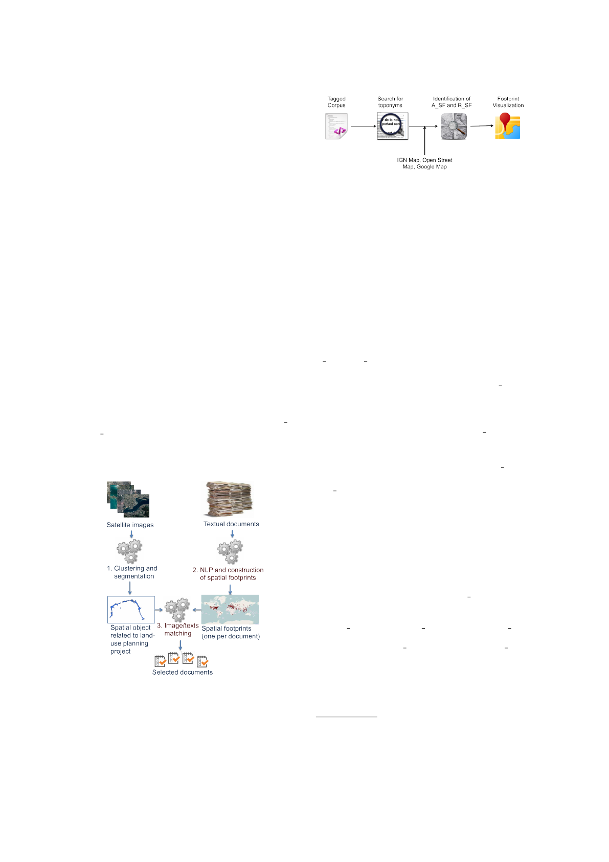
approach is divided into three stages (see Figure 1).
In the first stage, the approach focuses on the semi-
automatic extraction of image objects from satellite
images, using temporal clustering and segmentation.
In the second stage, NLP methods have been applied
in order to identify linguistic features concerning spa-
tial information in the documents. The use of lexicons
and dedicated rules (Gaio and Nguyen, 2011) allows
us (1) to identify the absolute (e.g., ”Madrid”) and rel-
ative (e.g., ”south of Madrid”) Spatial Features (AS F
and R SF) and (2) to calculate the footprint of each
document. In the final stage, we propose to select tex-
tual documents in relation with the studied land-use
planning project.
Figure 1: General process of the ANIMITEX project.
In this paper, we focus on the second and third
stages. The following section describes the proposed
approach to construct footprints from textual docu-
Figure 2: From document to footprint definition: the three-
steps process.
ments, and then to match these documents with satel-
lite images using spatial representation.
3.2 Footprint Identification Process
To calculate the footprint, we propose a process con-
sisting of three steps (see Figure 2).
SF Marking: the text marking step is achieved
through an automatic framework containing all spec-
ifications proposed in (Gaio and Nguyen, 2011). This
framework outputs a structure incorporating the SF
definition proposed in the previous section. A list of
A SF and R SF can be extracted from each document
of the treated corpus.
SF Validation: for each identified A SF, we
check on external resources if there is a corresponding
spatial representation. In particular, we have used lay-
ers provided by the IGN
3
(municipalities, roads, rail-
ways, buildings, etc.). In addition, if an A SF does not
present on IGN resources, we use gazetteers (Geon-
ames and Open Street Maps) to complete the infor-
mation. Concerning the representation of R SF, we
use spatial indicators of topological order associates
to A SF.
Following the scopes proposed in (Sallaberry
et al., 2008), the spatial indicators of topological
order have been grouped in five categories:
• Proximity: Different indicators can be used in
relationship of proximity, such as “near”, “around”,
“beside”, “close to”, ”periphery”, etc. To represent
this relationship, we define a Tolerance Zone T Z.
This area built around the studied A SF will be cal-
culated as follows:
T Z(A SF) = sur f ace(A SF) + φ ∗ sur f ace(A SF)
where sur f ace(A SF) is the surface of A SF on
which the relationship is docked. The value of φ is
fixed by taking into account the needs of experts and
in particular the size of the studied area.
• Distance: The indicators used in this relation-
ship are of the form: “x km”, “x miles”, etc. Two
3
National Institute of Geographic and Forestry Informa-
tion - www.ign.fr
When Textual Information Becomes Spatial Information Compatible with Satellite Images
303
representations are then proposed in our approach: 1)
calculus of distance from the centroid of the A SF and
construction of a circular buffer of size x from the cen-
troid; 2) regarding the shape of the A SF and building
a buffer of size x from the edge of the processed A SF.
• Inclusion: This binary operation allows us to
check if an A SF is inside another by taking into ac-
count indicators such as “center”, “in the heart”, “in”,
“inside”, etc. Two types of inclusion are considered:
1) full inclusion, for instance, the expression “the
town of Sete is in the Herault region”; 2) partial in-
clusion (i.e. intersection), for instance, “departmental
road RD2 crosses (partly included) Poussan town”.
• Orientation: This unary relationship has been
broadly studied in the literature. Different approaches
have been proposed to identify a cardinal points of an
A SF. We have chosen to use the conical model pro-
posed in (Frank, 1991). For this, we use the centroid
of A SF and we build a buffer around. The size of
this buffer will be calculated by taking into account
the surface of the studied A SF. Then we decompose
the buffer into four equal areas (forming a “X”) from
the centroid. Each intersection between the buffer and
cones thus formed represent the four cardinal points.
• Geometry: Geometry relations are built from at
least two A SF. These relationships are, for example,
the union, the adjacency, the difference or a position
of an A SF with respect to other A SF, for example,
C between A and B (where A,B and C are A SF), etc.
Representation of the Footprint: After the ex-
traction step and spatial representation of the A SF
and R SF, the footprint associated with the treated
document can be mapped. In this process, two main
problems have been identified. The first one is the
persistent ambiguity of some named entity contained
in SF because some named entities correspond to sev-
eral places, e.g. ”Montagnac”. To address this issue,
a configurable spatial filter based on predefined sce-
narios has been developed. For example, to identify
events related to a specific land-use planning project
occurred in a part of the area of the Thau lagoon, only
the SF contained in this area will be explored. The
second issue is related to the use of external resources
and the identification of the spatial representation ap-
propriate to each A SF. Taking into account the spatial
indicator (e.g. ”town”, ”road”, etc.) preceding by the
toponymic name is a first answer because it allows us
to specify the type of the SF and thus take into account
the appropriate spatial representation.
4 EXPERIMENTS
4.1 Data Preprocessing
A set of newspaper articles (i.e. 3809 documents)
concerning the Thau basin from 2010 up to 2013 has
been acquired. A second part of the data set is com-
posed of three Pleiades satellite images (2 m pixel size
and 4 spectral bands) covering the entire Thau basin
region. Satellite images are available via the GEO-
SUD Equipex
4
.
As cited before, in this article we propose a pro-
cess to identify and construct footprints from textual
documents to help the remote sensing analysts to ex-
plain changes. To achieve this, we need two inputs.
1) In one hand, we have to identify a spatial rep-
resentation of a spatial object related to the land-use
planning project that we want to address. This spatial
representation is obtained thanks to a remote sensing
process applied over a time series of satellite images.
The goal is to find abrupt and unexplained changes in
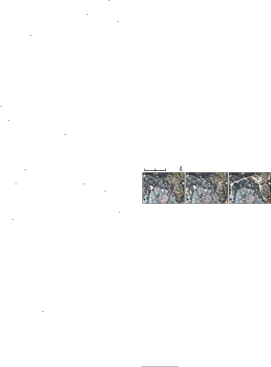
this time series. The three Pleiades images used in
this work were acquired on 10 July 2012, 14 Septem-
ber 2012, and 15 March 2013 (see Figure 3).
0 500 1000 m
10 July 2012 14 September 2012 15 March 2013
Figure 3: Visible color composite of the three Pleiades
images showing the construction of a bypass north of
Villeveyrac (France).
First, a temporal clustering is performed over the
Villeveyrac area (K-means algorithm with 12 classes).
One of the obtained clusters (see Figure 4.a. - blue
color) is related to the atypical change represent-
ing the bypass construction. Then, a segmentation
(MeanShift algorithm) is applied over the temporal
clustering results. In total, 1711 objects are obtained
from the segmentation (see Figure 4.b.) and 8 of them
correspond to the bypass construction. These 8 ob-
jects are exported as a single multi-polygon vecto-
rial layer (see Figure 4.c.) and represent the footprint
of the Villeveyrac bypass extracted from the Pleiades
time series.
2) In the other hand, we have at our disposal an
extract of our corpus containing 3809 newspapers ar-
ticles provided by the French press Midi Libre. This
corpus is related to the Thau basin region from 2010
up to 2013.
4
http://www.equipex-geosud.fr/
KDIR 2015 - 7th International Conference on Knowledge Discovery and Information Retrieval
304
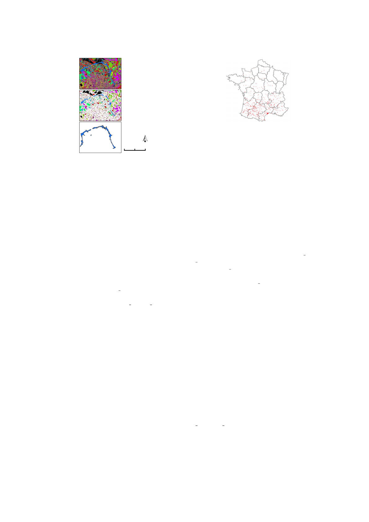
0 500 1000 m
b)
a)
c)
Figure 4: Clustering, segmentation and vector output from
the Pleiades time series processing around the Villeveyrac
area.
4.2 The Process to Match Images and
Textual Documents
Once the textual corpus collected, the process, de-
scribed in Section 3.2, has been applied to extract
SF (see Table 1). There are two outputs files. The
first one is A XML file, in which SF are identified
and marked by a tag < SF >. A SF is validated if it
is present in the external geographical resources used
(IGN and gazetteers).
In the XML file, one of the tags expresses a spatial
relationship between one or two SF. Indeed, tag indi-
rection represents one of the five categories of spatial
relations described in Section 3. We can take advan-
tage of indirections to build R SF. To do this, all com-
ponents in < indirection > tag are explored in order
to extract information to extend A SF to R SF. In this
manner, some SF associated to spatial relationships
can be extended to approximate SF towards the spatial
representation of the event identified in the use-case.
The second file (structured in JSON format) rep-
resents the geographical characteristics of confirmed
SF. In fact, once SF is validated, geographical infor-
mation describing the SF is collected from resources.
This information is, for example, the Lambert coor-
dinates, the resource name, times that SF appears in
resources, etc. This information is presented follow-
ing a JSON structure.
Figure 5 represents validated spatial entities ex-
tracted from 3809 documents. As presented in Table
1 (see line 1), 252575 spatial entities are identified
and validated.
In this context, an important issue has to be tack-
led: a validated SF could represent different locations.
For example, the SF “Croissiles” is a municipality lo-
cated in 3 different areas in France: Pas-de-Calais,
Calvados and Orne. In the same way, “Calais” is a
Figure 5: Spatial entities identified from corpus over the
French territory.
town located in United States and as well in the north
of France.
To address this problem and reduce the noise as-
sociated to the ambiguity of spatial entities, we have
filtered spatial entities located in the studied area (us-
ing Lambert coordinates). The treated experimental
land-use planning project is the construction of the
Villeveyrac bypass, which represents a small part of
the Thau basin region. Thanks to this filtering step,
we reduce by 95% potentially SF candidates (from
252575 points to 2090 SF, see Table 1, lines 1 and 2).
Nevertheless, our goal is to be as close as possible
to an event that appeared in a specific area located
thanks to our scenario. The representation using a
simple point is not enough. In this work, we pro-
pose to take into account representation of A SF and
R SF extracted by our process (see Section 3.2). For
instance, the A SF “the town of Villeveyrac” can be
represented by a polygon (corresponding to territory
of the municipality), the A SF “the road R2” can be
represented by lines (it is a departmental road), etc.
These representations are obtained using external re-
sources as IGN maps, GeoNames, etc. We have pro-
posed a top-down geographic granularity level, from
departments to buildings (in France). However, three
types of representations have been considered for our
experiments: municipalities, roads, and buildings be-
cause of the studied scenario that covers a relatively
small area. Figure 6 shows 4 footprints, generated by
our approach, which are in intersection relation with
the spatial object representing the Villeveyrac bypass.
As presented in Section 3.2, a footprint is obtained by
the union of all validated SF extracted from a docu-
ment.
We note that footprints are spatially closer to
event previously identified in the representation of the
treated spatial object (extracted from satellite images
and related to the Villeveyrac bypass construction)
thanks to Absolute and Relative Spatial Features (cf.
A
SF and R SF). Our method enables to identify a
footprint for 754 textual documents, e.g. these doc-
uments contain at least one SF located in the studied
area (see Table 1, line 4). From this selection, 279
When Textual Information Becomes Spatial Information Compatible with Satellite Images
305
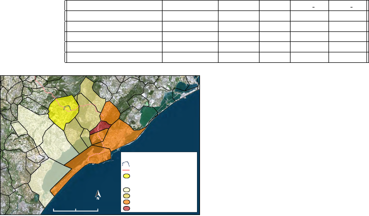
Table 1: Experiments on a corpus of 3809 articles.
Steps Nb Documents Nb Points Nb SF Nb A SF Nb R SF
1. Initial corpus 3809 252575 - - -
2. Filtering by the spatial area 758 2090 - - -
3. Intersection with points 0 0 - - -
4. Documents with footprints 758 - 2090 1992 98
5. Intersection with footprints 279 - 763 677 96
0
1
2 km
SF of the Villeveyrac bypass
SF of the "road R2"
SF of the "city of Villeveyrac"
(present in all documents)
Footprint of document id=89
Footprint of document id=393
Footprint of document id=2701
Footprint of document id=1453
Map Key
Mediterranean
Sea
Figure 6: Representation of footprint related to 4 selected
documents.
documents have got a footprint in intersection with
the spatial object representing the Villeveyrac bypass
(see Table 1, line 5).
In this work the footprints are identified, the next
step is to analyze the document content to identify the
ones referring to the event defined in the scenario.
5 CONCLUSION AND FUTURE
WORK
This paper presents the first step of a methodology
for extracting spatial footprint associated with textual
documents. The main issue is to identify textual docu-
ments containing spatial footprint associated to satel-
lite images, and this work is part of the ANIMITEX
project. We have used the spatial relation of inter-
section to identify textual documents related to the
same area of the spatial object representing the sce-
nario. The second step will be performed via several
spatial operators (i.e. distance, orientation, covering,
etc.) according to a protocol which has to be fixed and
in adequacy with the needs of the experts.
Finally, we propose to evaluate the reproducibil-
ity and relevance of experiments on other corpora and
associated to a distinct land-use planning context.
ACKNOWLEDGEMENTS
The authors thank Midi Libre (French newspaper)
for its expertise on the corpus, and all of the part-
ners of ANIMITEX. This work is partially funded by
Mastodons CNRS grant, and GEOSUD Equipex.
REFERENCES
Cohn, A. G. (1996). Calculi for qualitative spatial reason-
ing. Artificial Intelligence and Symbolic Mathemati-
cal Computation, 1138(5):124–143.
Davis, E. (2013). Qualitative spatial reasoning in interpret-
ing text and narrative. Spatial Cognition & Computa-
tion, 13(4):264–294.
Forestier, G., Puissant, A., Wemmert, C., and Ganc¸arski,
P. (2012). Knowledge-based region labeling for re-
mote sensing image interpretation. Computers, Envi-
ronment and Urban Systems, 36(5):470–480.
Frank, A. (1991). Qualitative spatial reasoning with cardi-
nal directions. Seventh Austrian Conference on Artifi-
cial Intelligence, 287:157–167.
Gaio, M. and Nguyen, V. (2011). Towards heterogeneous
resources-based ambiguity reduction of sub-typed ge-
ographic named entities. In Int. Conf. of GeoSpatial
Semantics (GeoS), pages 217–234.
Hern
´
andez, D., Clementini, E., and Felice, P. (1995). Qual-
itative distances. Spatial Information Theory A Theo-
retical Basis for GIS, 988:45–57.
Hollenstein, L. and Purves, R. (2010). Exploring place
through user-generated content: Using flickr tags to
describe city cores. J. Spatial Information Science,
1(1):21–48.
Leidner, J. L. and Lieberman, M. D. (2011). Detecting ge-
ographical references in the form of place names and
associated spatial natural language. SIGSPATIAL Spe-
cial, 3(2):5–11.
Lesbegueries, J., Gaio, M., and Loustau, P. (2006). Geo-
graphical information access for non-structured data.
In ACM Symposium on Applied Computing (SAC ’06),
ACM, pages 83–89.
Maurel, D., Friburger, N., Antoine, J.-Y., Eshkol-Taravella,
I., and Nouvel, D. (2011). Casen: a transducer cascade
to recognize french named entities. TAL, 52(1):69–96.
Sallaberry, C., Gaio, M., and Lesbegueries, J. (2008).
Fuzzying gis topological functions for gir needs. In
5th ACM Work. On Geog. Inf. Ret., pages 1–8.
Smith, D. A. and Mann, G. S. (2003). Bootstrapping to-
ponym classifiers. In Proceedings of the HLT-NAACL
2003 Workshop on Analysis of Geographic References
- Volume 1, pages 45–49.
KDIR 2015 - 7th International Conference on Knowledge Discovery and Information Retrieval
306
