
The Status and Disaster Losses of Seawater Intrusion in Kiaochow
Bay Region
Jianwei
ZHANG
1,2,3
, Shuya HU
1
and Zhongcheng LU
3
1
Department of Environmental Sciences, Qingdao University, Qingdao 266071, China
2
School of Ocean Sciences, China University of Geosciences (Beijing), Beijing 100083, China
3
Geo-Engineering Investigation Institute of Qingdao, Qingdao 266100, China
{f_author, t_author} dragonzjw@126.com
Keywords: Seawater Intrusion, The Status, Disaster Losses, Kiaochow Bay Region.
Abstract: By analyzing the history about seawater intrusion of the Dagu river estuary, Baisha river estuary, Yang river
estuary and Xin’an region, we study the seawater intrusion in Kiaochow Bay region. With the content of Cl
-
200mg/L, 250mg/L, 300mg/L in groundwater as main index, we divide Kiaochow Bay region into four
parts: non-seawater intrusion region, the slight one, the more serious one and the severe one. And we can
conclude that the most serious seawater intrusion region is the river estuary, it will be gradually less serious
in backland and two banks of rivers. We estimate the direct economic of the seawater intrusion region.
1 INTRODUCTION
Human long-term remaking nature and developing
economy, destroyed the natural environment of
relative balance(
Cao B X, 1995
). Excessive
exploitation of water resources makes the situation
of the water resources and ecological environment is
becoming more and more serious. Almost all coastal
areas are densely populated areas. A large amount of
water demand has caused great pressure on
groundwater resources, and excessive exploitation of
groundwater has become more serious. In Europe,
there are at least 100 areas affected by seawater
intrusion effect(
Scheidleger A, 2004
); such as the
Netherlands, have the enough fresh water resources
from the river and the atmosphere, but more than 20
wells forced to close by the action of seawater
intrusion in the past few decades(
Freedman V and
Ibaraki M, 2002; Stuyfzand P J et al, 2004
).
Kiaochow Bay is the mother Gulf of Qingdao, is
located in the south of Shandong Peninsula, also
known as the Jiaoao. There are the Nanjiao River,
Dagu River and other rivers flow into the Kiaochow
Bay. The seawater intrusion of Kiaochow Bay
region originated in the 1970ˊs, which has been
developed for several decades, and the scale of
invasion has been increasing(
Luan X M et al, 2009
).
2 DEFINITION OF SEAWATER
INTRUSION
Xue Yuqun gives the definition of seawater intrusion
from the perspective of its mechanism and
evolution(
Xue Y Q et al, 1992
): if the groundwater
was pumped more than recharged it, when the
groundwater head of the coastal zone decreases to
below the head of the sea water, the interface
between salt water and fresh water is going to be
pushed to the land until a new balance is formed,
that is the seawater intrusion. Wang Bingchen gives
the definition of seawater intrusion from the angle of
influence(
Wang B C, 1995
): seawater intrusion is a
natural phenomenon due to the decline of the
groundwater level in land caused seawater intruding
to the aquifer in the coastal areas. Jiang Jiali
analysed seawater intrusion from the angle of
inducement(
Jiang J L, 2002
): in the coastal areas, over
exploitation of groundwater leads to groundwater
depth decline, then the dynamic balance of salt water
and fresh water was destroyed, that the groundwater
is directly invaded by the sea water.
15
HU S., LU Z. and Zhang J.
The Status and Disaster Losses of Seawater Intrusion in Kiaochow Bay Region.
DOI: 10.5220/0006018300150019
In Proceedings of the Information Science and Management Engineering III (ISME 2015), pages 15-19
ISBN: 978-989-758-163-2
Copyright
c
2015 by SCITEPRESS – Science and Technology Publications, Lda. All rights reserved
15

3 RESEARCH AREAS AND
METHODS
3.1 Research Area
Shandong province and Qingdao city carried out the
strategy of protection and development surrounding
the Kiaochow Bay Region. Within all variety of
geological hazards which exist in Kiaochow Bay
region, seawater intrusion is of the largest scale, the
most influential and the most serious hazard losses.
Therefore, study area includes the West of Shinan
District, the old port area, the West of Sifang
District, Hongdao area, Shaohai of Jiaozhou city,
Huangdao eastern regional area, that the total area is
about 500km
2
.
3.2 Research Methods
We get the newest seawater intrusion data of the
content of Cl
-
and other chemical composition in
groundwater, which corresponds to a hydrological
year’s. With the different content of Cl
-
as main
standard of the seawater intrusion degree, we
divided Kiaochow Bay region into serious parts. We
evaluated the disaster loss of seawater intrusion by
the mathematical methods.
4 TYPICAL SEAWATER
INTRUSION AREA
The seawater intrusion of Kiaochow Bay coastal
areas began in the 1970's, and the start time and the
process of development are different in the different
shore section, the interannual change and the
influence factors are different also, and take
prevention measures of seawater intrusion also
varies. Typical seawater intrusion area includes four
shore section of Dagu River downstream, Baisha
River downstream, Yang River downstream and
Huangdao Xinˊan area.
4.1 Downstream of the Dagu River
In the downstream area of Dagu river has large
distribution of salt water. Its marine silt sediment
layer has been extended to Lancun of Jimo North.
Since 1981 developed the groundwater of Dagu
River downstream to supply the Qingdao city,
Ligezhuang area has formed groundwater drawdown
funnel about 100km
2
, and the lowest groundwater
level -8.18m in the center, caused seawater intrusion
gradually in the southern and southeastern. At the
same time, because the poor management of
Nanzhuang Dongfeng gate in the downstream of the
Dagu River, resulting the seawater traced back to
Hejiazhuang village, and distance estuary up to
12km. Because of groundwater level is lower,
seawater intrusion is very favorable, resulting in
groundwater quality deteriorated significantly along
both banks of the river, compared to 1988 and 1981,
the front of seawater intrusion carried about 750m,
the effect area is 3km
2
. After 1990, with the water
conveyance project from the Yellow River to
Qingdao city, the amount of groundwater
exploitation reduced, and precipitation increased
than the 1980s, the high water period of funnel does
not occur again after 1994. In 1997, the engineering
of underground seepage prevention curtain wall has
constructed in Xiaomawan, salt water not to expand.
overall, the Cl
-
concentration and salinity have
downward trend. During the extremely dry years of
2002, downstream of the Dagu River seawater
intrusion area did not change much due to take
measures in advance. After 2004 and 2005 years, the
groundwater has supplied, seawater intrusion trend
slowed down significantly, groundwater quality has
the signs of recovery. But near the Ligezhuang area
of seawater intrusion, the exploitation area of
groundwater is mining, the water supply capacity is
reducing, so that residents using water is difficult.
4.2 Downstream of the Baisha River
Baisha downstream is the groundwater source area
near Qingdao city. Its aquifer is the alluvium and
diluvium of the Baisha River, and has excellent
quality water in the 1960s. In the 1970s,
groundwater overexploitation, underground water
level gradually decreased, that caused seawater
intrusion. In 1984, it has formed groundwater
drawdown funnel about 25km
2
, and the lowest
groundwater level -9m in the center. So it became
the earliest and most harmful area of seawater
intrusion in Qingdao city. In the middle of the
1980's, the seawater intrusion area reached 8.5km
2
.
Until 1985, under the influence of the ninth
Typhoon, the seawater intrusion has eased, and then
continued to develop slowly. It is the abundance of
groundwater in 1990, the groundwater funnel were
pacified, and groundwater exploitation amount is
reduced, to compensate the groundwater, seawater
intrusion area stepped back a little. It is extremely
dry year in 2002, seawater intrusion increased, some
villages disaster is very serious, such as Qianhaixi
village is completely surrounded by salt water, near
ISME 2015 - Information Science and Management Engineering III
16
ISME 2015 - International Conference on Information System and Management Engineering
16

the little water can be drunk. As the vegetable
planting base of Qingdao, seawater intrusion caused
vegetable cannot grow, that yield 70%, grain also
significantly cuts or even, a large number of wells
scrapped.
4.3 Downstream of the Yanghe River
The groundwater exploitation in downstream of the
Yanghe River based on agricultural water supply,
and the area is five small river estuary (also known
as the "five river estuary "). Seawater along the river
upstream, caused seawater intrusion, the intrusion
area has occurred large area of grain production and
wells scrapped phenomenon.
4.4 Downstream of the Xin’an River
Seawayer intrusion area is located in Xin’anhe River
downstream estuary, and the distance to the coast
nearest less than 500m. Because of the mining
amount greatly exceeds the natural recharge in the
1980s, the water level drops quickly, the lowest
water level elevation is -3m, leads to seawater
intrusion. Since the beginning of 1986, the distances
of seawater intrusion is 600m or so. The amount of
the mining is reduced gradually until the total is
stopped.in 1986 ~1995 years, At present, there are
some phenomena such as land salinization, farmland
damage, rural water use difficult and so on. Now
surface water is the main supply source, the trend of
the intrusion of sea water has been contained.
5 DISTRIBUTION
CHARACTERISTICS OF
SEAWATER INTRUSION
5.1 Status Survey
Seawater intrusion is affected by human factors, is
due to the over exploitation of groundwater,
saltwater and freshwater interface changed, seawater
intrusion into freshwater aquifers, form the disaster.
So the range and distribution of seawater intrusion is
in constant change. Through the investigation of the
current situation of the seawater intrusion in a
hydrological year, we can get the latest data of
intrusion.
A total of 544 groundwater samples were
collected. In the sample collection process, we also
investigate the water intake point information, such
as the landscape, environment, mining methods and
others.
Samples were collected by successive encryption
sampling method, a total of three times. First, 220
groundwater samples were collected in the region,
according to the results of laboratory tests to
understand the overall situation of water quality.
Then according to the distribution of Cl
-
content, in
the distribution of the 200mg/L, 250mg/L and
300mg/L boundary lines are encrypted 200 samples.
Finally, according to the results of the previous two
analysis, we selected the key and the typical section
to collect 124 samples. So there are two purposes.
One is to fill some of the sampling area by the
supplementary sampling in the study area. Two is a
better analysis of the characteristics about the
current situation of seawater intrusion through the
targeted encryption.
5.2 Status Characteristics
According to the results of Cl
-
, we used the Excel
software and Surfer software to generate the
equivalent line automatically. Isoline map and
MapGIS map were corrected, and the Cl
-
content
said in a location map.
With the content of Cl
-
200mg/L 250mg/L
300mg/L in groundwater as main index we divide
Kiaochow Bay region into four parts: non-seawater
intrusion region, the slight one, the more serious one
and the severe one. And we can conclude that the
most serious seawater intrusion region is the river
estuary of Dagu river, Baisha river and Yang river
and Xin’an region of Huang island, it will be
gradually less serious in backland and two banks of
rivers.
5.3 Seawater Intrusion Area
The invasion area was low, the ground elevation is
generally less than 10m. The formation is the
Quaternary sedimentary layer. According to the
different geographical position, from the coastline to
the Cl
-
concentration of 250mg/L, we can get the
area ratio of the affected area of the seawater
intrusion.
Dagu River downstream region of seawater
intrusion affected area is the largest, accounting for
main intrusion zone 46%. Followed by Baisha
downstream, the Yanghe River downstream area,
and the area of seawater intrusion in Huangdao area
is the smallest, which accounts for 9% of the main
invasion area. The area of seawater intrusion is
The Status and Disaster Losses of Seawater Intrusion in Kiaochow Bay Region
17
The Status and Disaster Losses of Seawater Intrusion in Kiaochow Bay Region
17
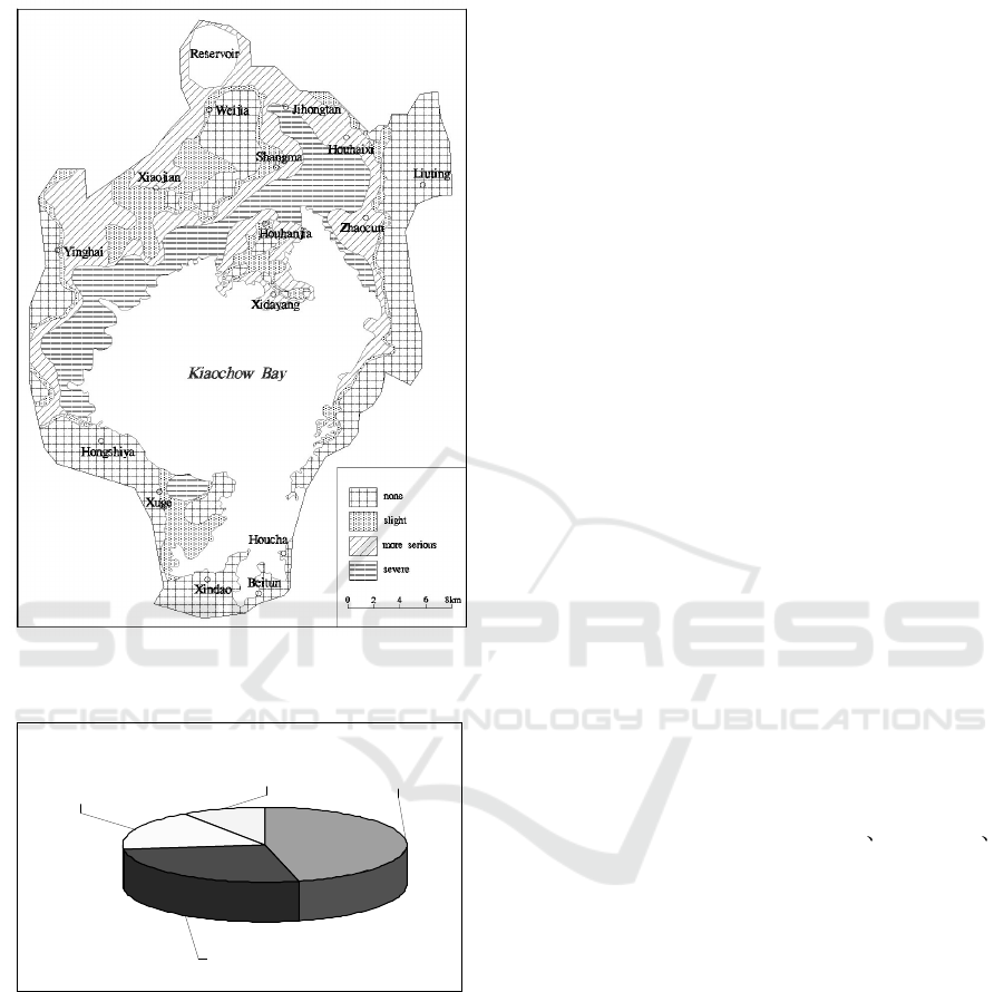
related to the regional hydrogeology, groundwater
utilization and exploitation.
Figure 1: Distribution of seawater intrusion area in the
Kiaochow Bay region.
Downstream of the
Baisha River
27%
Downstream of the
Yanghe River
18%
Downstream of the
Xin’an River
9%
Downstream of the
Dagu River
46%
Figure 2: Percentage of major seawater intrusion area.
6 LOSS OF SEAWATER
INTRUSION DISASTER
The seawater intrusion is a geological disaster of
slow degeneration, which has a wide distribution
area, which is often not easy to cause people's
attention, but the economic loss caused by it is huge
(
Li P et al, 2004
). The seawater intrusion area of
Kiaochow Bay is mainly in the farmland and
vegetable planting area, the seawater intrusion has
destroyed the underground fresh water resources,
which has brought the extremely disadvantageous
influence to the agricultural production. Due to
differences in lots of different soil texture and
cultivated species, it is difficult to accurately
calculate the seawater intrusion disaster loss. But
according to the value of agricultural production
caused by seawater intrusion, agricultural production
was more than 15% in the concentration of Cl
-
at
250mg/L~300mg/L area, and agricultural production
was more than 35% in the concentration of Cl
-
higher than 300mg/L area.
In the Kiaochow Bay region, the concentration
of Cl
-
at 250mg/L~300mg/L area is 114.5km
2
, and
the concentration of Cl
-
higher than 300mg/L area is
73.5km
2
. The normal agricultural output of
Kiaochow Bay coastal areas is 4.5 million yuan/km
2
.
Then in the area of the concentration Cl
-
at
250mg/L~300mg/L, agricultural production loss:
114.5km
2
× 4.5 million yuan/km
2
×15%=77.29
million yuan
And in the area of the concentration Cl
-
higher
than 300mg/L, agricultural production loss:
73.5km
2
× 4.5 million yuan/km
2
× 35%=115.76
million yuan
The sum of these two is the total disaster loss,
that is to estimate the direct economic losses caused
by seawater intrusion in the Kiaochow Bay region
every year, about 193.05 million yuan.
7 CONCLUSIONS
With the content of Cl
-
200mg/L 250mg/L
300mg/L in groundwater as main index, we divide
Kiaochow Bay region into four parts: non-seawater
intrusion region, the slight one, the more serious one
and the severe one. And we can conclude that the
most serious seawater intrusion region is the river
estuary, it will be gradually less serious in backland
and two banks of rivers.
We have evaluated the economic damage caused
by the seawater intrusion in the Kiaochow Bay
region, which is 193.05 million yuan every year.
ACKNOWLEDGEMENTS
The study is financially supported by the National
Natural Science Foundation of China (No.
41202175).
ISME 2015 - Information Science and Management Engineering III
18
ISME 2015 - International Conference on Information System and Management Engineering
18

REFERENCES
Cao B X., 1995. Geomorphology and Quaternary Geology,
Wuhan: China University of Geosciences press.
Freedman V and Ibaraki M, 2002. Effects of chemical
reactions on density-dependent fluid flow: on the
numerical formulation and the development of
instabilities, Adv. Water Resour, 25: 439-453.
Jiang J L, 2002. Research on the seawater intrusion in the
coastal area of Huludao, Journal of China Hydrology,
22 (2): 27-31.
Li P, Li P Y, Xu X Y, et al., 2004. Effect of human
activities on the coastal zone disaster environment,
Coastal Engineering, 23 (4): 45-49.
Luan X M, Zheng X L, Lin G Q et al., 2009. Numerical
simulation of groundwater in the downstream of the
Dagu River, Qingdao, Groundwater, 31 (3): 7-10.
Scheidleger A, Grath J, Lindinger H., 2004. Saltwater
intrusion due to groundwater over exploitation—EEA
inventory throughout Europe, 18
th
Salt Water Intrusion
Meeting, Cartagena, Spain.
Stuyfzand P J, Maas K, Kappelh J et al., 2004. Pumping
brackish groundwater to prepare drinking water and
keep salinized wells fresh, 18
th
Salt Water Intrusion
Meeting, Cartagena, Spain.
Wang B C., 1995. Groundwater development and
utilization and management, Chengdu: Electronic
Science and Technology University Press.
Xue Y Q, Xie C H, Wu J C., 1992. Research on the
seawater intrusion, Hydrogeology & Engineering
Geology, 19 (6): 29-33.
APPENDIX
Zhang Jianwei (1980-), male, post doctoral, research
interests include coastal geological, environmental
geology, etc.
[E-Mail:] dragonzjw@126.com
The Status and Disaster Losses of Seawater Intrusion in Kiaochow Bay Region
19
The Status and Disaster Losses of Seawater Intrusion in Kiaochow Bay Region
19
