
Empowering the Elderly: Implementation of Navigation Assistance
Application for Public Transportation
Samuli Heinonen and Erkki Siira
VTT Technical Research Centre of Finland Ltd, Kaitoväylä 1, 90571, Oulu, Finland
Keywords: Public Transportation, Navigation, Mobile Services, Elderly, Error Detection.
Abstract: When a human ages, the functional abilities could weaken, which can lead to isolation from the society.
Applying technological aid for improving the quality of life of the elderly helps them to stay independent
and active in their community across their life. This article introduces a system, which is empowering the
elderly by aiding them in using public transportation in both rural and urban environments, and helps them
in this way to maintain the mobility and activity. The ASSISTANT system provides a simple, yet effective,
route info for user and shows only relevant information, at the right time and in the appropriate format. The
system is communicating with the user via audio and visual guidance. In addition, it has an error detection
functionality, which helps user in case of common navigation errors. End user evaluation performed in
Helsinki (Finland), Vienna (Austria) and Donostia-San Sebastian area (Spain) confirms that the service
works as intended and helps older people to use public transport by guiding them all the way from the start
to the end of their journeys. The system was found to be particularly helpful on unfamiliar routes.
1 INTRODUCTION
Public transportation is perhaps the most important
mode of transport among the elderly who live in
cities. (Social Exclusion Unit, 2013) Public
transportation becomes a primary mode of transport
when they lose the ability to drive. To learn how to
use the public transportation might be challenging
for elders. Utilizing public transportation in
unfamiliar places might be stressful even for people
with normal cognitive and sensory abilities.
In the ASSISTANT project we have developed a
system, which aids elderly in using public
transportation in urban environments, and provides
simple, yet effective guidance for them.
ASSISTANT system provides only relevant
information, at the right time and in the appropriate
format, and the user interface supports both visual
and audio guidance. In addition, ASSISTANT
supports safety and security by its error trapping and
remediation functionality, which makes it responsive
to the user’s physical, cognitive and mental
capacities and preferences using the ICT already
available.
2 RELATED RESEARCH
In the ASSISTANT project Carmien and Obach
(Carmien and Obach, 2013) have studied the
implications of getting lost and getting back on track
in public transportation. They approach the
happenstance of becoming lost as a form of error,
which anchors it to a long line of error research.
Their philosophy is based on Dekker’s (Dekker,
2006) suggestion in which errors are to be
considered more as a systemic event and not a solely
a human error. This makes errors easier to
understand and react-to from the system design point
of view. ASSISTANT’s theoretical background for
errors is done by Carmien and Obach whose main
research is on error capturing, error classification
and error mitigation in public transportation using
the mobile navigation systems.
Matthews and Wardman (Matthews and
Wardman, 2015) have studied how people with
physical mobility impairments would want to use
mobile application to help them in public transport
and private car setting and how much the users
would be willing to pay for different services the
mobile application could provide. When using
public transport the 59% users would be willing to
Heinonen, S. and Siira, E.
Empowering the Elderly: Implementation of Navigation Assistance Application for Public Transportation.
In Proceedings of the International Conference on Information and Communication Technologies for Ageing Well and e-Health (ICT4AWE 2016), pages 35-44
ISBN: 978-989-758-180-9
Copyright
c
2016 by SCITEPRESS – Science and Technology Publications, Lda. All rights reserved
35

purchase an app in contrast to 42% for car users. For
the car users, the most important services of which
they are willing to pay were:
the route directions
assistance in road breakdown situations, and
ability to pre-book disabled parking slots
For public transport users the most important
services of which they are willing to pay were:
the ability to pre-book staff assistance in
transportation hubs
pre-book a taxi for continuation of the trip
information on the next station/stop with the
arrival time
up to date connection information
accessibility info of the arriving vehicle
The amount of mobile applications which
provides public transport navigation support is
continuously growing. Even though new services are
appearing constantly, most of the newcomers are
aimed at public transport users without taking into
account specific user groups.
Assist-Mi (assist-Mi, 2014) operates in United
Kingdom and is planned for disabled users. It has no
journey planning or travel information, but support
organization people can see the user location and
provide help in difficult situations.
App&Town (App&Town, 2015) is a Spanish
(Barcelona, Madrid and Laval) navigation service
for users that are blind, partially-sighted, deaf or
physically disabled. It has several characteristics that
are shared with ASSISTANT, but it has no error
mitigation functionality.
GeorgiePhone (GeorgiePhone, 2014) operates in
United Kingdom. In the system, the pedestrian
guidance is emphasized. In the error situations, a
“help me” functionality contacts a garegiver.
Transit App (Transit App, 2015) is a free local
transportation planner for mobile phones. It operates
in 100 big cities across the USA. They also support
Canada and many cities in Europe and Mexico.
Transit App does have a support for real-time
information. On the other hand, it is not designed for
special groups and it does not have error mitigation
functionality in it.
Moovit (Moovit, 2015) is also a free, local transit
planner app for mobile phones featuring live arrival
times, updated line schedules, local station maps,
service alerts & changes that affects users’ trip.
Moovit supports hundreds of cities around the world
including many European cities. Moovit presents the
planned route in legs and shows the path in a map. It
also gives textual information how to walk to the
nearest bus stop. While user is in the vehicle, the app
gives a list of the stops during a route. There is no
error mitigation functionality available in the app.
There are even more mobile apps for public
transportation navigation (e.g. TRAFI, Citymapper,
Avenue-Public Transport). Many have a pedestrian
guidance showing a path in a map or by giving a
textual guidance for walking leg, but rarely they do
have error mitigation functionality or other aid for
supporting user in case they get lost.
3 ASSISTANT PROJECT
ASSISTANT (Aiding Sustainable Independent
Senior Travellers to Navigate in Towns) project is a
pan-European joint project under AAL Programme
(Active and Assisted Living Programme, 2015). In
the project there are seven companies from five
European countries – Austria, Finland, France, Great
Britain and Spain. The project contributes to
maintaining the mobility of older people in Europe.
Motivation is in safeguarding their social and
economic participation in aging society by
introducing a navigation assistance service to
support their journeys in urban areas.
The ASSISTANT project was divided into three
phases. First phase in spring 2013 identified which
kind of application would be needed to assist elders
in public transport system. Second phase in spring
2014 had a first version of the system that was tested
in real world environment with the elderly in three
European cities – Vienna, Austria; Helsinki, Finland
and San Sebastian, Spain. Test included both the
creation as well as the execution of a journey from
Point-A to Point-B. To ensure support in case of
operational problems or need for help, a person from
ASSISTANT project was present all the time during
the tests. The third phase in 2015 had a polished
navigation assistance system that was piloted in
same three European cities with the elderly.
3.1 ASSISTANT Use Case
Main goal of the project was to improve the usage of
public transport for older travellers. A user may
navigate independently in public transport network
using a mobile phone application. The application is
connected with back-end system that keeps the
status of the traveller and the status of the public
transport network up to date. The user plans a route
by using a web application and the route is uploaded
to the mobile application for further use.
ASSISTANT project has a clearly defined target
use case that was laid down at the beginning of the
project and consistently pursued. Such use case is
ICT4AWE 2016 - 2nd International Conference on Information and Communication Technologies for Ageing Well and e-Health
36

split into two parts: route planning and navigation.
Route planning: When the user decided to go to a
theatre. At first, she log in to ASSISTANT website,
enter her preferences and fill in if she has any
caretakers that the system should contact to in case
of an error. On route planner tab, she enters date and
time for the journey, her home as a start address and
the theatre as destination. A map view shows the
route, starting point and the destination. If she is
pleased with the plan, she presses ‘send to mobile’
button and the plan is sent to user’s mobile device.
Navigation: Mobile device will acknowledge that
it has received the information and then waits until
the time for the journey comes up. Application alerts
the user beforehand that she should get ready for the
journey. When the journey starts, the application
will show arrow-based pedestrian guidance to the
public transportation stop. When user gets to the
stop the application guides user to get the right
vehicle and shows how the journey continues while
she is sitting in the vehicle. When destination or
transfer stop gets closer the application will notify
the user. There is an arrow-based guidance from
transfer stop to the stop she needs to go to catch
another vehicle or from the stop to the destination.
4 DESIGN RATIONALES FOR
THE ASSISTANT SYSTEM
The needs of the target group of the elderly users
were reflected on to five rationales that were seen as
essential for the ASSISTANT system to implement.
The five characteristics are:
Personalization and customization
Research-based interface for the elderly
Route planning metadata with accessibility
information
Help for the last kilometre
Design for failure
These characteristics themselves are not new or
unique, but the use of the combination of them
makes the system unique for elderly and disabled
users. Our main contribution to the field of
navigational services is ‘design for failure’ and it is
being discussed in Chapter 5 in more detail.
Personalization and customization was the first
characteristic that was chosen. The elderly people
have very different kind of disabilities and the
ASSISTANT system was designed to be helpful for
the people with different needs. When users have
disabilities the normal look-and-feel might not be
functional enough and the service is thus not usable.
To create functional service for disabled users, the
system needs to take into account the users’ special
needs. Here are two possible approaches. System
can be split up and design services individually to
address different disabilities or it may be designed to
be flexible and customizable. ASSISTANT took the
latter approach. ASSISTANT’s customization and
personalization tries to provide only the relevant
information, at the right time and using visual,
haptic and audio cues to communicate.
The second characteristic is research-based
interface for the elderly. There is a large body of
research about how user interfaces should be
constructed for elderly users. In addition to
academic research, we have performed two
developmental incremental phases with the target
user group, where they have been able to affect
which kind of user interfaces they prefer and they
have been able to confirm or unconfirm the choices
made by the design team. From research we derived
several user interface guidelines for ASSISTANT
(Carmien and Garzo, 2014). In addition, TELSCAN
project provided lots of guidelines how to implement
for elderly and disabled. (TELSCAN, 1997)
The third characteristic is using accessibility
information in route planning. This characteristic is
ASSISTANT’s way to create possibility for
continuous accessible path of travel. Normal route
planning services do not utilize this information
when routing people from place to another. For the
elderly this might be a deal breaker, because of
disabilities they do not want to end up on a train
platform where they can’t exit for example because
of long and steep stairs. This characteristic has
proved the most difficult to implement in pilot cities,
because getting the accessibility information is
difficult as the information is usually not up to date
and might not even reflect the real world conditions.
The fourth characteristic is help for the last (and
first) kilometre. This means that system will help the
pedestrian part of the journey in addition to the use
of public transportation system. The grounding
philosophical approach in ASSISTANT was that the
user will be guided from the doorstep to the
destination. ASSISTANT last-kilometer guidance
includes both a compass-based arrow guidance and a
map-based guidance. Route planners and
navigational guides typically only do routing
through the public transportation system and maybe
add a rough map for the pedestrian part of the
journey.
Empowering the Elderly: Implementation of Navigation Assistance Application for Public Transportation
37

5 CATCHING ERRORS
ASSISTANT system is designed to be able to catch
and mitigate the errors during the navigation. An
ability to catch and recover from errors is one of the
main features of ASSISTANT system and it is the
main difference with other similar navigation
systems.
5.1 Design for Failure
As mentioned in design rationales for the system in
previous chapter (Chapter 4), one of our design
principles in ASSISTANT project was the so-called
“Design for Failure”. Design for Failure in the
context of ASSISTANT means, that at some point of
use something will go wrong. It might be a human
error, lack of network coverage or fault in the public
transportation system, but inevitably everything does
not go as planned. Because of this, the navigational
system needs to be able to react for errors somehow,
and be reliable enough so that the user can trust that
he or she is not left alone and lost. ASSISTANT has
a process to enable recovery from failure.
5.2 Error Detection
In ASSISTANT system there are several ways to
detect an error. Our approach to error detection is
that the route navigation is based on a state machine.
In every state there might be different errors.
5.3 State Machine
In order to be able to give precise and compact
guidance to the user, the application needs to have
reliable identification of the user state (e.g. walking,
in the vehicle or at a stop). When the system detects
an error, it categorizes it based on the user’s state
and then it will try to remediate the situation.
The ASSISTANT mobile application has four
main context states: idle, walking, at stop and in
vehicle. (See Figure 1). Transitions between the
states are identified by different sensors: compass,
speed, bearing and accelerometer. State transitions
are described here:
T1 idle to walking
T2 walking to stop
T3 stop to vehicle
T4 vehicle to stop
T5 stop to walking
T6 walking to idle
A successful route starts from the home (or other
origin) and goes through all of these states. If route
includes the vehicle changes, it is possible that state
machine cycles between WALKING - AT STOP -
IN VEHICLE – states as long as route lasts.
IDLE WALKING ATSTOP INVEHICLE
T1 T2 T3
T6 T5 T4
Figure 1: Mobile app state machine.
Errors in the journey itself are easier to catch and
recover, because the system itself can work to fix the
problem. More difficult problems are those where
the system itself does not function as planned. For
example loss of network, loss of battery power or
weak GPS signal are problems that affect the
performance of the system severely. To react these
types of problems, the system has a caretaker
register in the database. If the system fails, the
caretakers are notified that the user is missing and
the system cannot help enough. The back-end
system will then help the caretaker to its best ability
to regain contact with the user. Thus, the user can
trust that if everything else fails there still is a person
that knows where she was going to and what was the
error that happened during the journey.
5.4 Error Remediation
Next we take a look what are the most common
errors and how the system recovers from these errors
during the route
User is Walking to Wrong Direction
While the user is guided on the First/Last kilometre,
she is travelling by walk. Normally she may use the
compass to see the direction where to go or use the
map to see her route to the next waypoint. However,
it might be possible that she put the mobile phone in
her pocket, when she may forget the right direction.
Now, if she has been walking to the totally wrong
direction (the distance to the waypoint is continually
extended) for more than 3 seconds, the Assistant app
warns (as seen in Figure 2) her by the dialog and
also by saying aloud: “You are walking to the wrong
direction!”
Missed Stop while Travelling by Vehicle
While user is travelling e.g. by the bus and she is
approaching the destination stop, she is informed
about this on the second-last stop. When user arrive
ICT4AWE 2016 - 2nd International Conference on Information and Communication Technologies for Ageing Well and e-Health
38
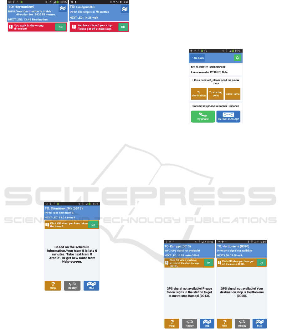
Figure 2: Warning - dialogs.
the destination stop, the user is advised to get off. If
the user travels past the destination stop, assistant
app informs user (see Figure 2) by a dialog saying:
“You have missed your bus stop. Please get off at
the next stop.” When user has step out of the bus, the
system calculates the new route to destination, and
the navigation continues as normally.
Missed Vehicle while Waiting the Transport on a
Stop
Sometimes user may be a bit late from the stop
where she was planned to get on the transport, and
her vehicle may have already left the stop. If there is
real-time information available, ASSISTANT
system could provide information about the next
vehicle departure time. If real-time information is
not available, system needs to utilize the schedule
information for further guidance. Then, the user is
asked to refresh the route to see when the next
appropriate vehicle will arrive to the stop. Figure 4
shows the dialog to the user.
Figure 3: Missed vehicle dialog on the stop.
User Gets Lost during the Route
If user gets lost during the route in any point, he can
ask help from the Assistant app HELP-screen which
is seen in Figure 5. There are 5 different alternatives:
1. Get a route to destination. This action creates a
new route to the planned destination.
2. Get a route to starting point. This action creates
a new route to the starting point.
3. Get a route back home. This action creates a
new route to the user’s home.
4. Connect to the contact person by Phone. This
action makes a phone call to the user’s contact
person for asking more help.
5. Connect to the contact person by SMS. This
action send’s a SMS message to the user’s
contact person for informing her about troubles
on the route.
Figure 4: HELP-screen.
GPS Signal Lost
Navigating in urban environment with the help of
GPS is sometimes challenging. High buildings form
urban canyons, where GPS signal may be weak
temporarily. The navigation module in the mobile
application tolerates the short and temporary GPS
signal lost during navigation without disturbing user
about that too sensitively. The user is informed only
if the GPS signal has been lost more than 15 seconds
by saying: “GPS signal not available!” In addition,
Assistant app tells user the next waypoint where she
was travelling, so she can try to continue the
navigation on her own.
Figure 5: Guidance during the Metro leg.
Metro Leg, no GPS Signal Available
If user travels by metro, it is mandatory to go below
the ground, where GPS signal is not available. In the
Figure 6 it can be seen how the application informs
user about the lost GPS signal, and request to follow
the signs in the station to get to the metro stop.
Empowering the Elderly: Implementation of Navigation Assistance Application for Public Transportation
39
When user has is on the metro, the name of the
destination stop is shown. Finally, when user has
reached the destination stop by metro and she comes
on the ground, the GPS signal comes available and
user is guided to her destination as normally.
Mobile Data Connection Lost
While user is travelling, Assistant system keeps
track on her progress by sending so called ‘I-am-
alive’-message to the server every five minutes
automatically. ‘I-am-alive’-messages include
information about mobile phone battery level,
current state of the route (walking-stop-in vehicle),
and current location. If server does not receive
messages from the mobile phone in every five
minutes, a SMS message is sent to the user’s contact
person. The reason for system fail may be a mobile
data connection lost or some unpredictable and
serious application error. The example of the SMS
message is here: “Mobile phone is unreachable for
Mr. West. Phone battery level was 50% and Mr.
West was travelling by tram. Mr. West has most
recently been located at Mannerheimintie 2,
Helsinki.” When SMS is sent to the contact person, a
responsibility to help user is moving to the contact
person.
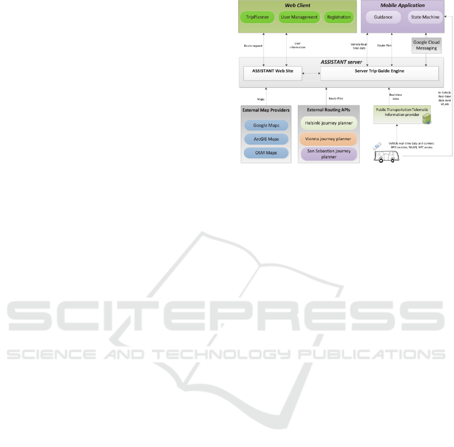
6 SYSTEM ARCHITECTURE
ASSISTANT system follows a traditional client-
server architecture, where mobile phone client
communicates with back-end server-based
application. Server retrieves updated maps,
schedules and telematics data from external sources.
The system offers a web site with the set of features
such as trip planning and caretaker support. The
Figure 6 gives a high-level architecture of the
system and its relations to the external systems.
The main components of the ASSISTANT
system consist of a mobile application running on
the Android device carried by the user, and a
backend system interacting with the mobile
application asynchronously over the Internet. The
main role of the backend system is to provide public
transport route planning functionality, and profile
management services. The server is also used to
monitor the systems interactions for storing error
states in order that the system can provide error
mitigation functions for user.
Figure 6: High-level system design.
6.1 Components
There are five main components in the ASSISTANT
system: Web Client, Mobile Application, Server,
External Routing APIs and External Map Providers.
Web client is used for user registration, user
management and trip planning. With the web client,
user can create user accounts and adjust user
preferences, like walk speed, home addresses,
telephone numbers etc. More importantly, user can
plan public transport routes by using trip planner.
The Server hosts the web site, where the web client
is installed. There are two ways to get routes for the
user: the trip guide engine may request route plans
from external routing APIs and modify the route to
ASSISTANT-specific format or it can use
OpenTripPlanner (OpenTripPlanner, 2014) module
(inside of Trip Guide Engine) to create routes from
the raw schedule information. When route is created,
it is sent to the mobile application, which starts the
guidance when the planned route is about to start.
External Map providers are used to clarify the
overall view of route for user. ASSISTANT server
can utilize maps from Google and OpenStreetMap.
6.2 Communication
Communication between server and client is handled
using REST API. It means that server is stateless, it
has uniform interface, communication is based on
client-server architecture and system follows the
standard https-based security mechanisms. If the
server needs to contact the mobile client, it sends
GCM (Google Cloud Messaging) message to the
client with appropriate parameters. For example, if
user has created a new route by using the web client,
the server sends a GCM-message to the mobile
client to inform about the new route. The mobile
ICT4AWE 2016 - 2nd International Conference on Information and Communication Technologies for Ageing Well and e-Health
40
application’s GCM-listener notices the message and
starts to download route information from the server
in pre-determined XML format.
6.3 Real-time Information
The ASSISTANT system is able to utilize real-time
information during the navigation. Real-time
information in public transportation can be utilized
two ways:
1. The local route planner’s telematics server
provides the real-time information through the
web interface. The ASSISTANT server requests
the data from the telematics server and delivers
it to the mobile application. Real-time
information is used to make public
transportation guidance more accurate. For
example, while user is waiting a vehicle on the
stop, she can receive real-time information of
the vehicle arrival time.
2. Gathering real-time data in vehicle stops and in
vehicles over the on-board vehicle
WLAN/Bluetooth. Every vehicle could have
their own WLAN/Bluetooth base station, which
is used to identify the right vehicle in heavy
traffics stops. In addition, the vehicle itself can
provide route information, disruption data, etc.
for user through the specified API. In metros,
user could get exact information about time
schedules and upcoming stops.
Using WLAN/Bluetooth hotspot in vehicles will
solve the problem of user mistakenly boarding a
wrong vehicle. In Helsinki there is a new vehicle on-
board WLAN/BT system under development, but
other pilot cities (Vienna and San Sebastian) do not
offer WLAN hotspots in their vehicles, so the
ASSISTANT system did not utilize on-board
WLAN for real-time data delivery.
7 GRAPHICAL USER
INTERFACE
In this section a Graphical User Interface (GUI) of
the ASSISTANT System is introduced. First we go
through Web Route Planner GUI, and after that, a
GUI of a Mobile Application is introduced.
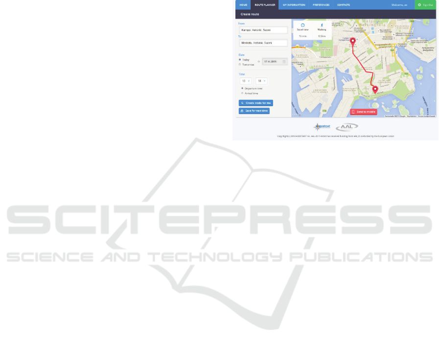
7.1 Web Route Planner
The use case of ASSISTANT System is was
described in section 3.1. If the user is using the
system first time, the user should first create and
define a user profile in ‘My Information’- and
‘Preferences’-tabs. The user should give a name, a
phone number, an email address and a home street
address. In addition, in user can define attributes,
like personal walking speed and alert sounds to
customize a system to better fit on the user’s needs.
Figure 7: Route Planner-tab on ASSISTANT web site.
When the user has finished creating a user profile, it
is possible to plan a route by using ‘Route Planner’-
tab. The figure (Figure 7) is a screenshot from
‘Route Planner’-tab. In this screen, the user gives
start and end addresses, and desired time for the
route. This makes the system to calculate a new
route and which can be seen in a map. The route can
be send to the mobile client by “Send to mobile”-
button.
7.2 Mobile Application
Currently Loaded Routes – Screen
The main screen of the mobile application can be
seen in Figure 8. Screen lists all the routes which are
loaded to the mobile client. In this screen user can
delete old routes, or see the details of the route. In
addition, user has an option to get help in any
moment by opening the HELP-screen.
Navigation – Screen
This screen shows all the textual information on the
top of the screen. There are three kind of
information available: 1. TO-field telling user the
next goal of the route; 2. INFO-field giving user a
textual advice how to reach the next goal, and; 3.
NEXT LEG-field which prepares user for the next
leg of the route. In the bottom of the screen there are
three buttons, which gives different kind of
assistance for user during the navigation: Help-
button opens the HELP-screen, Replay-button
reads aloud the INFO-field text again, and
Empowering the Elderly: Implementation of Navigation Assistance Application for Public Transportation
41
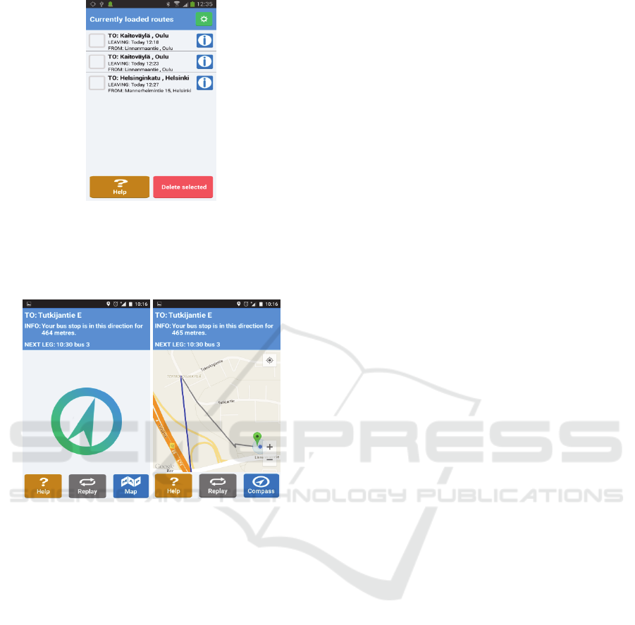
Figure 8: Currently loader routes - screen.
Map/Compass-button is used for switching between
map/compass views. Navigation screen can be seen
in Figure 9
Figure 9: Navigation-Screen (Compass- and Map-view).
Help – Screen
Figure 5 is showing the screenshot from the HELP –
screen. Mobile application utilizes the GPS signal to
locate user, and by taking advantage of the
geocoding, the app tells user the current location as
street address. In addition, there are buttons which
helps user to create routes to three different
destinations: 1) To destination, 2) To starting point
and 3) Back home. In the bottom of the screen there
are two buttons, which makes it possible to connect
with the user’s contact person by making a phone
call or sending a SMS message.
8 END USER PILOTS
In ASSISTANT project we had two evaluation
phases: the first one was arranged in spring 2014 and
the second one was arranged in spring 2015. The
system was improved based on the analysis of the
first pilot’s results. The general objective of the
second evaluation phase was to gather feedback
from the representatives of the target user group
(mobile older adults who are over 65 years old) not
only to evaluate the usability and the usefulness of
the system but also to track system bugs and errors
for future development.
8.1 Organization
End user testing in spring 2015 was organized in
three cities simultaneously: Helsinki (Finland),
Vienna (Austria) and San Sebastian (Spain). The test
users were outfitted with smartphones for two
weeks, and it was ensured that everybody have a
personal computer with internet connection at their
home. The test users were asked to use the
ASSISTANT system in their everyday life and not
to change their mobility habits for the testing period.
The project partners have a common
methodology for the testing sessions ensuring that
the results from the three testing sites are
comparable and that all the test participants are
treated in an equal manner. At each testing site, one
project partner was responsible for organizing the
testing sessions, recruitment of the testers,
acquisition of the testing material and carrying out
the tests by applying the testing methodology.
The test users participated in an initial workshop,
which ensured that they understood their role in the
evaluation and learned how the system functions.
Then, during the two weeks, they used ASSISTANT
system to guide their routes in the local public
transports. The testers recorded their user
experiences in a specific diary. In the end of the test
phase, the participants were gathered for a final
discussion where they were able to exchange their
user experiences with the test administrator.
8.2 Results and Analysis
As a result of end user testing, some testers used the
system more often than the others. Furthermore,
some of the users were more comfortable with the
system than others, and in consequence some
requested help from the test administrator and the
others did not. The Table 1 below demonstrates
statistical information from the end user pilots 2015.
Even though some system bugs and some
usability difficulties occurred during the two-week
autonomous testing, the general attitude of the users
were very positive and they consider that once they
trust ASSISTANT system, it would encourage them
to be more mobile and to take the public transports
more often. Furthermore, several participants said
ICT4AWE 2016 - 2nd International Conference on Information and Communication Technologies for Ageing Well and e-Health
42

Table 1: Statistics from the second end user pilots.
CITY
A number
of created
routes
A number of
routes sent to
the Mobile
client
A number
of
finished
routes
HELSINKI 315 162 23
VIENNA 271 150 14
SAN
SEBASTIAN
465 - 22
that this service is helpful when taking unknown
route or when travelling in previously unknown city.
The essential recommendation that the testers
gave is that ASSISTANT system should interact
more with the user’s needs; all functionalities should
be optional so that the user could adapt them
according to their ICT-skills and functionality needs.
Another important feedback from the testers was
that the users need the possibility to change and
create routes on the mobile phone too. People want
to be flexible: they cannot plan their entire journey
ahead and they don’t carry a computer with them. It
is nice to have the possibility to send routes from a
computer but when people get used to handling a
smartphone, they can use the service with a
smartphone more efficiently. There was quite much
discussion of enabling route planning in mobile
application in early design stages of the project, but
in the end we limited it to the three choices of ‘to
original goal’, ‘to home’ and ‘to route start’. The
design rationale for these was twofold:
1. We decided early on to eliminate the need to
use on-screen keyboards, because elderly may
have difficulty of using tiny keyboards on
mobile phone, and
2. When the screen is divided into data display and
keyboard / text input areas the data must be
displayed in much smaller font making the use
of the system difficult for elders.
This evaluation confirmed that the system
provides a helpful service for the end-user when
using public transportation and notably when taking
new unknown routes where the user needs to trust
the guidance provided by the system. The general
reaction was that the system is relatively easy to use
in the context of both devices. As a conclusion, it
was noticed that based on the evaluation the
ASSISTANT project fulfilled 85 % of the initial
user requirements (14/17 items achieved).
9 FUTURE WORK
Even though the current version of the ASSISTANT
system is a well-functioning service, it is not
completely ready yet. There are a couple of missing
features which needs some development work
before the system is ready for markets.
One of the features missing in the current system
is its inability to recognize the right vehicle while
user was waiting it on the stop. As mentioned on
section 6, on-board WLAN/Bluetooth hotspots could
help with this challenge. Furthermore, there has been
recently published new devices on markets called
Bluetooth Beacons. In essence, Bluetooth Beacon
technology allows mobile applications to understand
their position on a micro-local scale, and deliver
hyper-contextual content to users based on location.
In that sense, Bluetooth Beacons could be utilized in
ASSISTANT as follows: Beacons could be mounted
in public transport vehicles. While the user is
waiting a vehicle on a stop, the application can
detect the arriving vehicles by listening the vehicle
Beacon signals. When the signal is strong enough,
the user can be guided to get on to the right vehicle.
Another missing feature in ASSISTANT is its
inability to plan new routes on-the-fly during the
navigation. This feature is easy to implement, and a
test version of that is existing already.
In order that the system could be taken into use
in other cities, a specific server module and a couple
of configuration files should be updated and tailored
to support the local transportation operator’s route
format. Finally, all the GUI text labels on Mobile
Application and Web Route Planner must be
translated to the host country language.
10 CONCLUSIONS
In this paper we introduced The ASSISTANT
system, which is developed in ASSISTANT project.
System can be used by the home PC and smartphone
and it helps older travellers plan public transport
journeys and then provides guidance during their
journeys. ASSISTANT includes:
A web browser based on-line means of
planning a trip
Guidance on making multi-step journeys
Alerts which tells the user when it is time to
leave or board the vehicle
Error detection and mitigation during the trip
ASSISTANT system helps older people to travel
safely and independently by public transport. The
system offers a seamless support for the entire
length of a journey in urban environments.
An ability to catch and recover from errors is one
Empowering the Elderly: Implementation of Navigation Assistance Application for Public Transportation
43

of the main features of ASSISTANT system and it
makes the difference with other navigation systems.
End user evaluation confirmed that the
ASSISTANT system provides a helpful service for
the end-user when using public transportation and
notably when taking unknown routes where the user
needs to trust the guidance provided by the system.
ACKNOWLEDGEMENTS
The authors would like to thank ASSISTANT
project partners for the good cooperation during the
project. In addition, we would like to thank our
financier Tekes (the Finnish Funding Agency for
Innovation) and AAL Program for their support for
this research work.
REFERENCES
Active and Assisted Living Programme Referenced from
http://www.aal-europe.eu/ 4th of September 2015.
App&Town - website 2015 Referenced from http:/
/www.appandtown.com/ 11th of September 2015.
assist-Mi -website 2014 Referenced from www.assist-
mi.com 15th of October 2015.
Avenue - Public Transport, Google Play Market website
2015 Referenced from https://play.google.com/store/
apps/details?id=com.pocketavenue&hl=en 15th of
October 2015.
Carmien, S. and Garzo, A., Elders using smartphones: a
set of research based heuristic guidelines for designers,
in 16th International Conference on Human-Computer
Interaction (HCII 09) in the parallel session
"Cognitive Accessibility and Cognitive Support" in the
8th international Conference on Universal Access in
Human-Computer Interaction (UAHCI),2014,
Springer LNCS, Lecture Notes in Computer Science
Heraklion, Crete, Greece. p. 26-37.
Carmien, S. and Obach, M. 2013 Back on Track: Lost and
Found on Public Transportation. 15
th
International
Conference on Human-Computer Interaction (HCII
09) in the parallel session "Cognitive Accessibility and
Cognitive Support" in the 7th International
Conference on Universal Access in Human-Computer
Interaction (UAHCI), 21-26 July, 2013, Las Vegas,
Nevada, USA, Springer LNCS, Proceedings Part II
Part V pp 575-584.
Citymapper - website 2015 Referenced from
https://citymapper.com/berlin 11th of September 2015.
Dekker, S. 2006. The field Guide to Understanding
Human Error, p. 236. Ashgate, Burlington, Vermont,
USA.
GeorgiePhone – website 2015. Referenced from
www.georgiephone.com 15th of October 2015.
HaptiMap-project – website 2015 Referenced from
http://www.haptimap.org/ 15th of October 2015.
Matthews and Wardman 2015, Travel apps for disabled
people: Evaluating their contribution toward inclusive
transport, Proceedings of Transed2015 conference
Jun/2015 Lisbon, Portugal.
Moovit - website 2015 Referenced from http://
moovitapp.com/ 10th of September 2015.
OnTheBus 2014. Referenced from www.onthebus-
project.com/index.html 15th of October 2015.
OpenTripPlanner 2014 The open trip planner organisation
- Multimodal trip planning & analysis. 201 7/5/2014];
Available from: http://www.opentripplanner.org.
Social Exclusion Unit. 2003. Making the connections:
Final report on transport and social exclusion. London:
Social Exclusion Unit, Office of the Deputy Prime
Minister.
TELSCAN 1997, Inventory of ATT System Requirements
for Elderly and Disabled Drivers and Travellers.
Report from Transport Telematics Project No. TR
1108. Deliverable 3.1 Referenced from
ftp://ftp.cordis.europa.eu/pub/telematics/docs/tap_tran
sport/telscan_d3.1.pdf 26th of February 2015.
Trafi App - website 2015 Referenced from http://
www.trafi.com/ 10th of September 2015.
Transit App - website 2015 Referenced from http://
transitapp.com/ 8th of October 2015.
ICT4AWE 2016 - 2nd International Conference on Information and Communication Technologies for Ageing Well and e-Health
44
