
edpMGB - A Metadata Editor Built as SaaS for the Brazilian
Geospatial Metadata Profile
Marcos Montanari, Vitor Dias, Eduardo Lourenço and Jugurta Lisboa-Filho
Department of Informatics, Federal University of Viçosa, Viçosa, MG, Brazil
Keywords: Spatial Data Infrastructure, INDE, Editor, Metadata, MGB Profile.
Abstract: Aiming to encourage the reuse and prevent wasting resources in the production of spatial data, in 2008, the
Brazilian government edited Act 6,666, instituting the National Spatial Data Infrastructure (Infraestrutura
Nacional de Dados Espaciais - INDE). To meet the need of geospatial data documentation, the INDE
defined the Brazilian Geospatial Metadata (MGB) profile based on ISO 19115:2003. This paper describes
the development of edpMGB, a metadata editor for the MGB profile. The editor is open-source and is being
released in the cloud via Web following the Software as a Service (SaaS) model, so it can be accessed from
any point on the Internet, requiring only a Web browser. This editor was developed on the scope of the
research and development project (R&D) Geoportal Cemig – SDI-based corporate GIS (Geoportal Cemig -
SIG corporativo baseado em IDE), whose objective is the implementation of a corporate SDI for the Minas
Gerais Power Company (Companhia Energética de Minas Gerais - Cemig).
1 INTRODUCTION
Within Information and Communication
Technology, information redundancy and lack of
data standardization proves very common. The same
data often ends up being produced, managed, used,
and stored by several independent producers that use
different formats and standards, who seek to meet
exclusively the individual needs of specific users
(Dornelles and Iescheck, 2013).
The greater production of spatial data requires
documenting them so they can be reused. A piece of
data immersed in its context becomes information,
however, with no such documentation, it is virtually
worthless information (Nebert, 2004).
In order to prevent actions in duplicity and
wasted resources to obtain spatial data, the Brazilian
government began, in 2003, studies aiming to
integrate and reuse geospatial data produced by the
different federal administration organs. In 2008, Act
6,666 of November 27th established the National
Spatial Data Infrastructure (Infraestrutura Nacional
de Dados Espaciais - INDE) (Brasil, 2008). INDE’s
goal is “to catalog, integrate, and harmonize the
geospatial data produced and maintained by the
different governmental institutions so as to facilitate
their location, exploration, and access by any user
connected to the Internet” (Concar, 2009).
To Leme (2006), geographic metadata
correspond to the documentation of geographic data
and are created according to standards. Such
standards consist of a set of regulations that allow
the geographic data to be described textually in a
previously established manner (Leme, 2006). The
most well-known geographic metadata standards
were defined by the Federal Geographic Data
Committee (FGDC) and by the International
Organization of Standards (ISO). These institutions
established international geographic metadata
standards that meet the needs of different users, thus
which comprises the variability in geographic
information (Prado et al., 2010).
In order to meet the metadata standardization
demands started by INDE, the National Cartography
Committee (CONCAR) created the Brazilian
Geospatial Metadata Profile (MGB Profile) based on
norm ISO 19115:2003. A metadata profile is a basic
set of elements that portray the characteristics of
geospatial products of a given community and
guarantees their identification (ISO, 2003).
Based on norm ISO 19139:2007, XML schemas
were defined to materialize and code ISO
19115:2003 as a file. Since the MGB profile is based
on norm ISO 19115:2003, its metadata must also
follow the materialization standards defined in norm
19139:2007 to increase the interoperability among
24
Montanari, M., Dias, V., Lourenço, E. and Lisboa-Filho, J.
edpMGB - A Metadata Editor Built as SaaS for the Brazilian Geospatial Metadata Profile.
In Proceedings of the 2nd International Conference on Geographical Information Systems Theory, Applications and Management (GISTAM 2016), pages 24-31
ISBN: 978-989-758-188-5
Copyright
c
2016 by SCITEPRESS – Science and Technology Publications, Lda. All rights reserved

the systems that use the profile as their base (Pascoal
et al., 2013).
The present paper aims to describe the
development of edpMGB, a metadata editor for the
MGB profile. edpMGB is open-source software and
is available on the cloud via the web following the
model Software as a Service (SaaS). Thus, it can be
accessed from anywhere and requires only a web
browser (Weiss, 2007). Some features of this
metadata editor are also available through web
services, which allow other systems to use some of
this tool’s features.
This editor was developed in the context of the
research and development (R&D) project
“GeoPortal Cemig – SIG corporativo baseado em
IDE” (Cemig GeoPortal – SDI-based corporate GIS)
being developed to help implement a corporate SDI
for Minas Gerais Power Company - Cemig
(Compania Energética de Minas Gerais).
The main reason for developing edpMGB was
the need for a specific tool for this metadata standard
focusing on the Brazilian technical audience that
works with spatial information. Other editors are
available in the market, such as CatMDEdit
(Catmdedit, 2015) and GeoNetwork (GeoNetwork,
2012). Although these are metadata editors, they are
not specific for documenting metadata in the MGB
profile. GeoNetwork, in particular, can be used
alongside the editor described in the present study.
2 THEORETICAL FRAMEWORK
2.1 Cloud Computing
According to Armbrust et al. (2010), cloud
computing refers to applications provided as online
services as well as the hardware and software
systems that provide such services. These systems
favor the user’s access to different applications using
the internet, regardless of the platform used or where
the user is. Therefore, all data processing and
storage occurs at some online datacenter, as virtual
servers.
Cloud computing takes place through different
types of services. The main one, which will be
approached in this study, is the concept of Software
as a Service (SaaS) (Yang et al., 2011). This type of
service has several resources that the end user can
access via web browsers (Armbrust et al., 2010).
The metadata editor presented in this study is an
example of SaaS.
2.2 Web Services
According to the W3C (2004), a web service is a
software system designed to support the
interoperability among machines on a network. A
web service is accessed through platform-
independent protocols and data formats such as the
Hypertext Transfer Protocol (HTTP), eXtensible
Markup Language (XML), and Simple Object
Access Protocol (SOAP). A web service’s interface
is accessible through standardized XML messages,
i.e., in text format (Lopez-Pellicer, 2012).
The editor hereby presented makes available web
services that can be accessed via SOAP by any
application regardless of the technology used, with
no need to access the system’s interface. The
services can be used by developers that want to use
them in their applications.
2.3 Brazilian Geospatial Metadata
Profile (MGB Profile)
According to Pascoal et al., (2013), the purpose of
the MGB profile is to establish a national standard to
structure geospatial metadata. It was created with the
collaboration of representatives of Brazilian
geospatial-data-producing organs. The profile was
entirely based on the international norm ISO 19115
(ISO, 2003). However, this profile does not define
how these metadata are structured in electronic files,
which is managed by norm ISO 19139:2007. Based
on Pascoal et al., (2013), norm ISO 19139 aims to
materialize the concepts of ISO 19115:2003 into a
file by coding these metadata in XML schemas.
Before the MGB profile was created, the profiles
previously established in several other countries
were analyzed, all of which based on norm ISO
19115, such as the following profiles:
MIG – Metadados de Informação Geográfica
(Portugal);
NEM – Núcleo Español de Metadados (Spain);
NAP – North American Profile (USA/Canada);
LAMP – Latin American Metadata Profile
(proposed for Latin America).
The MGB profile has a simplified version called
summarized profile, which represents the minimum
elements the geospatial metadata must have. The
summarized profile has 23 elements, illustrated in
Table 1. The idea is to make the adoption of the full
MGB profile, comprising 82 elements, optional
while all data in Brazil must be documented with at
least this summarized core (Concar, 2009).
edpMGB - A Metadata Editor Built as SaaS for the Brazilian Geospatial Metadata Profile
25
When the MGB profile was being built, the ISO
19115 standard was analyzed in order to identify the
section, entities, and elements that describe the
characteristics of the geospatial data produced in
Brazil. Thus, the profile defines a subset of elements
available in ISO 19115, changes the cardinality of
some elements, and defines some code lists (Pascoal
et al., 2013).
The elements in the MGB profile are organized
into the following sections (Concar, 2009):
Section 1 (Identification) - provides basic
information on the geospatial dataset such as
title, date, person or institution responsible, and
summary of the data;
Section 2 (Identification of the geographic
dataset – GDS) - refers to the information
required to identify and evaluate a GDS. This
section characterizes the type of spatial
representation, scale, language, extension, etc.;
Section 3 (Restriction information) - publicizes
information regarding access and use restrictions
and is made up of two entities, one regarding
legal restrictions and the other, security
restrictions;
Section 4 (Quality) - allows the quality of a
dataset to be evaluated by informing the
hierarchical level, linage, and report on the data;
Section 5 (Maintenance information) - informs
the maintenance and update frequency;
Section 6 (Spatial representation information) -
describes the mechanisms used to represent the
spatial information (matrix or vector);
Section 7 (Reference system) - information on
the reference system, including the coordinates
system and the geodesic referential of the spatial
dataset;
Section 8 (Content information) - describes the
catalog of features and the content of the matrix
data;
Section 9 (Distribution) - reports information
related to the distributor and to the alternatives to
obtain geographic data;
Section 10 (Metadata) - section responsible for
information on its own metadata. It includes the
person or institution responsible, creation date,
norm used, etc.
2.4 Norm ISO 19139:2007
Norm ISO 19139:2007 defines a set of XML
schemas for metadata defined in ISO 19115:2003. It
aims to define a file format for geospatial metadata
that follows ISO 19115:2003. These schemas enable
structuring and validating the metadata’s XML files
in accordance with the norm (ISO, 2007). The XML
format allows the metadata instances to go around
the internet, including geospatial web services, as
predicted in the specification of the Web Services
Catalog (Nebert et al., 2007).
Maintained since 1998 by the W3C, XML is a
flexible and simple mark-up language. Its main
characteristics are being a text-based language,
separating content from formatting, being simple
and easily interpreted, and allowing the creation of
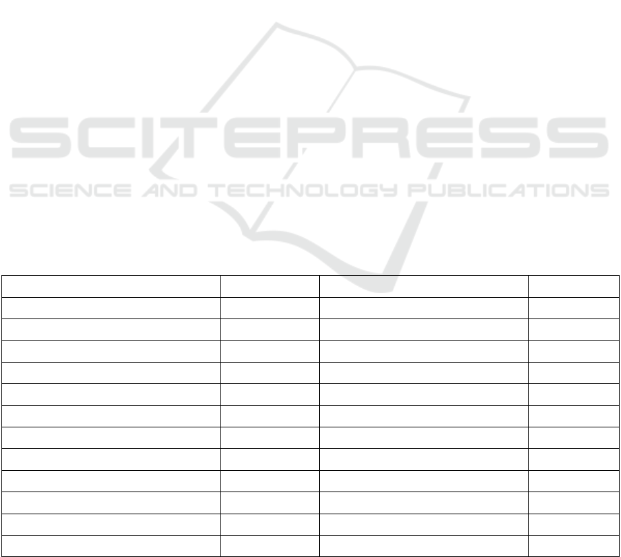
Table 1: Entities and elements of the metadata core of the summarized MGB profile.
Entity/Element Condition Entity/Element Condition
1. Title mandatory 13. Reference system mandatory
2. Date mandatory 14. Linage optional
3. Responsible mandatory 15. Online access optional
4. Geographic extension conditional 16. Metadata identifier optional
5. Language mandatory 17. Standard metadata name optional
6. Character encoding conditional 18. Metadata norm version optional
7. Thematic category mandatory 19. Metadata language conditional
8. Spatial resolution optional 20. Metadata character encoding conditional
9. Summary mandatory 21. Responsible for the metadata mandatory
10. Distribution format mandatory 22. Metadata date mandatory
11. Time and altimetry extension optional 23. Status mandatory
12. Type of spatial representation optional
GISTAM 2016 - 2nd International Conference on Geographical Information Systems Theory, Applications and Management
26

limitless tags, which facilitates online data exchange
(Goldberg, 2009). An XML document can be
considered well formatted if it matches what it
prescribed in the norms (Bray et al., 2006). This
document can be valid as long as it follows some
norms described in its grammar. The XML Schema
Definition (XSD) is an XML grammar format
(Fallside and Walmsley, 2004). ISO 19139 is
described as XML schemas built under the
specification by Thompson et al. (2004).
3 RELATED WORKS
Filling out metadata is hard work, as is any other
product cataloging.
The use of software to generate geographic
metadata files in several formats that meet different
norms has been proposed to improve geographic
data documentation. Among these tools, the
freeware ones such as CatMDEdit and GeoNetwork
stand out, both featuring forms to fill out the
metadata according to a pre-defined profile and
enabling the automatic extraction of some
characteristics from the dataset.
3.1 CatMDEdit
CatMDEdit (Catmdedit, 2015) is a tool to edit and
visualize metadata in several standards that
facilitates resource documentation, particularly
geographic information. It is developed by the
Instituto Geográfico Nacional de España (IGN)
along with the Advanced Information Systems
Group (IAAA) from the University of Zaragoza,
with technical support from the GeoSpatiumLab
(GSL). The tool was implemented in Java and has
important features for metadata documentation,
among which: The system is multiplatform (running
on Linux and Windows); multilingual (Spanish,
English, French, German, Polish, Portuguese, and
Czech); open source, supporting the automated
metadata file extraction and generation (Shapefile,
DGN, ECW, FICC, GeoTIFF, GIF/GFW, JPG/JGW,
PNG/PGW); and it converts and personalizes
metadata standards to generate new metadata
standards and profiles in order to serve all types of
geographic data.
3.2 GeoNetwork
GeoNetwork (GeoNetwork, 2012) is a standardized
decentralized environment based on a catalog
system to facilitate geospatial data access, recovery,
update, and management. It provides a complete
environment with metadata editor and catalog with
search functions. It also carries an online interactive
map viewer using web map service. It is currently
used in countless SDI initiatives worldwide. Some
of its main features include: (1) native support to the
metadata standards ISO 19115, ISO 19139, FGDC,
and Dublin Core, besides being able do configure a
new metadata standard profile; (2) metadata
synchronization among distributed catalogs; (3) user
management and customized access control; (4)
cataloging and access to several types of data and
documents (upload/download); (5) interface with
multilingual support; and (6) metadata importing in
the ISO 19115 standard into a metadata profile
configured in GeoNetwork. This system is free and
open-source, which facilitates its evolution and
customization by SDI developers.
What differentiates edpMGB from the editors
mentioned in this section is that the former is a SaaS
system that does not need to be installed on the
user’s machine, besides having a simplified interface
that helps users document metadata. Moreover, it is
the only editor specific for the MGB profile and its
interface has the local advantage of being in
Portuguese.
4 edpMGB - MGB PROFILE
METADATA EDITOR
Metadata documentation in the MGB profile is an
important task for them to be shared and reused. Up
until now, no other editor specific for the MGC
profile has been created, hence, each metadata set is
specified according to the preferences of their
authors (Pascoal et al., 2013).
edpMGB is a web application developed with the
Google Web toolkit (GWT), a framework developed
by Google for web-applications. The GWT used the
java programming language to develop applications
and the tool itself converts the JavaScript code so
that the application can be interpreted by any web
browser regardless of the platform the user is
running.
Through edpMGB, the user can create, edit, and
save metadata as a .xml file following international
standards so it can be used in several geospatial
tools. Before the XML file is generated, it must be
validated according to the MGB profile rules.
One of the components of GeoPortal Cemig is
the geospatial metadata catalog. Therefore, the
metadata are documented through edpMGB, thus
integrating SDI-Cemig to the INDE.
edpMGB - A Metadata Editor Built as SaaS for the Brazilian Geospatial Metadata Profile
27
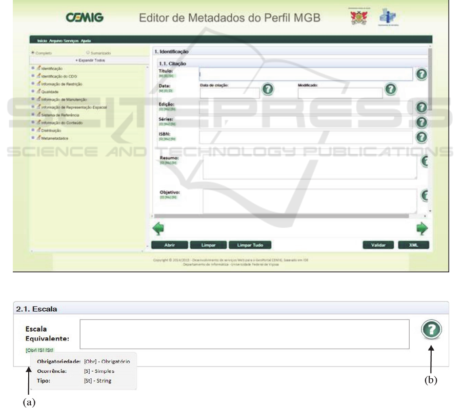
Figure 1 illustrates edpMGB’s home screen. The
left-hand side has the navigation tree separated into
sections and profile elements. The center-right area
features the screen with the MGB profile fields
divided into ten panels that represent the sections,
which may be accessed using the green arrows to the
right or to the left.
Figure 2 (a) shows the rules of enforcement,
occurrence, and type of value of an element. The
icon shown in Figure 2 (b) shows an element’s
detailed information.
The bottom part of the home screen features the
editor buttons panel. The button “Abrir” (Open)
displays the dialog box where the user can load an
XML file to be edited. Each element of the profile
will be loaded in its respective text box.
The button “Limpar” (Clear) clears the open
element’s text box, while “Limpar Tudo” (Clear All)
clears all text boxes of the metadata being edited.
The button “Validar” (Validate) performs one of
the system's main features, which is to validate
whether the metadata is in accordance with the XML
schema of the MGB profile. When the button is
clicked, the system verifies the data input and may
display, for instance, a dialog box as shown in
Figure 3 to inform that the metadata does not respect
the MGB profile’s rules. The dialog box displays an
error log alerting the user and showing which fields
are not in accordance with the rules. The user may
keep editing the metadata or store it in his or her
machine even if it is not validated for the MGB
profile. When a non-validated metadata is generated,
it is tagged informing it does not conform to the
MGB profile.
Figure 1: edpMGB’s home screen.
Figure 2: Warning dialog about mandatory elements.
GISTAM 2016 - 2nd International Conference on Geographical Information Systems Theory, Applications and Management
28
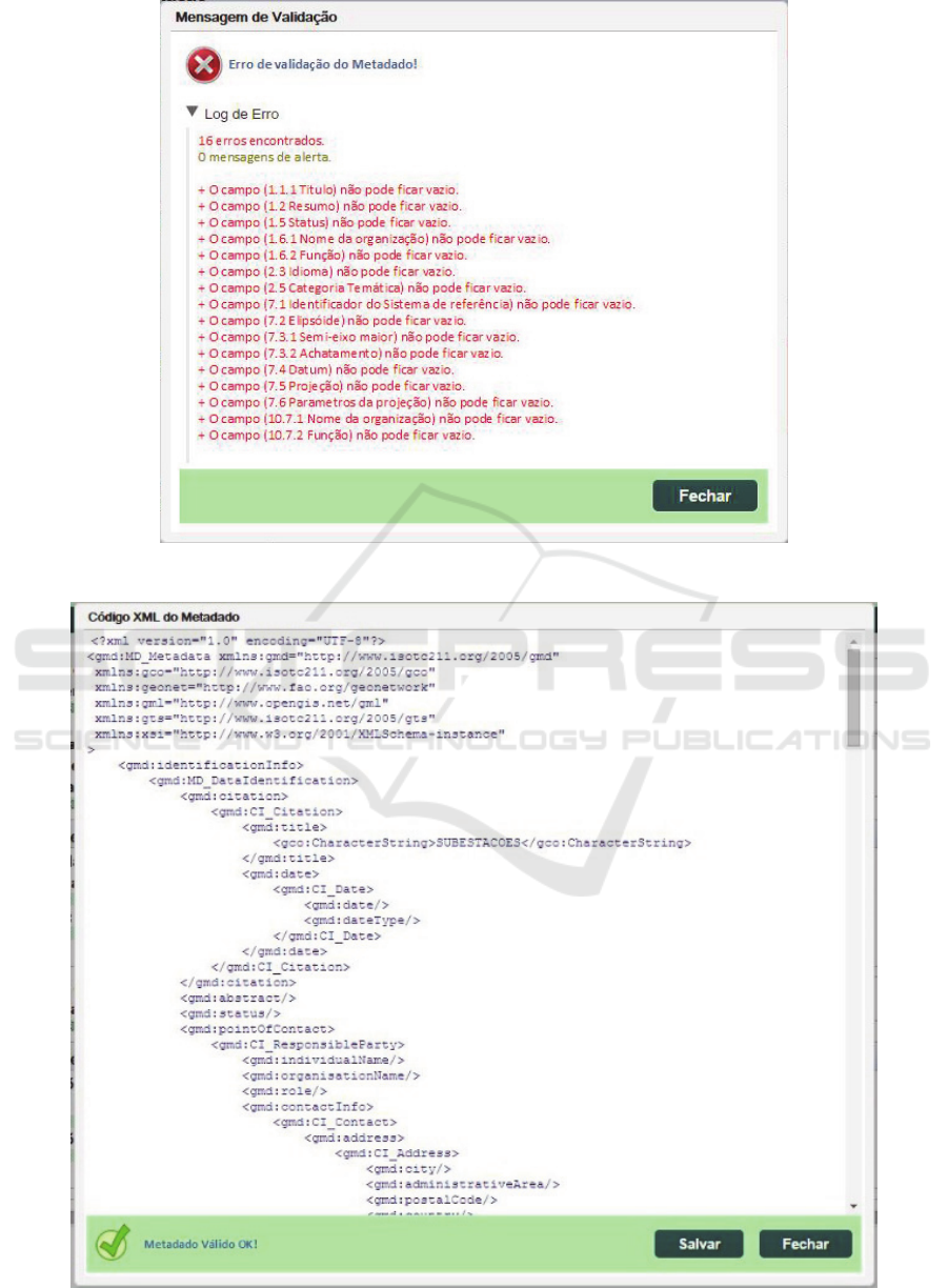
Figure 3: Result with errors found by the validation service.
Figure 4: XML file generation screen.
edpMGB - A Metadata Editor Built as SaaS for the Brazilian Geospatial Metadata Profile
29

A generateXMLScript() method receives as
parameter the elements of the MGB profile, which
are validated by the method validateMGB(), then the
former outputs the XML script as a string.
The method validateMGB() validates the
metadata according to the MGB profile, receiving its
elements as parameter and outputting a list with the
error messages found in the metadata or an empty
list in case it respects the profile.
To Pascoal et al., (2013), most metadata
provided by national data producers do not fully
respect the profile's rules, which is a big issue since
it compromises the interoperability among the
systems that use the same profile. Nonetheless, the
impossibility of saving a non-validated metadata
may cause problems to users, perhaps due to the lack
of information on the metadata elements. Hence, the
user has the option of saving the metadata even if it
does not conform to the MGB profile and, if needed,
load it again in the tool for further editing. The
“XML” button saves the metadata as a .xml file
(Figure 4) that contains all information input in the
fields. The .xml file is saved in the user’s computer.
5 CONCLUSIONS
The present paper presented the development of a
geographic metadata editor that follows the concept
of Software as a Service (SaaS) and is available to
any user with internet access. edpMGB was
developed specifically to create geospatial metadata
in accordance with the Perfil de Metadados
Geoespaciais do Brasil (MGB profile). Besides
using software developed in his or her native tongue,
the user has easy access to the system with no need
to install it locally. edpMGB may also be used to
change metadata sets created with other editors (e.g.,
Geonetwork).
The feature of validating whether the metadata is
in accordance with the standard defined by the MGB
profile helps produce higher quality, more complete
and correct metadata. However, the user may save
the documents still incomplete, in which case the
metadata receives a tag of non-conformity with the
MGB profile.
Since the XML validation and generation were
also developed as web services, other developers
will be able to remotely create applications (e.g.,
metadata catalog manager) that use the services
implemented in the tool through SOAP, which
broadens the tool’s reach.
As proved by Pascoal et al. (2013), most
metadata sets currently available in the INDE do not
conform to the MGB profile. Therefore, this
metadata editor with its XML schema conformity
validation service is an important contribution to
INDE’s evolution.
This editor was developed in the context of the
research and development (R&D) project
“GeoPortal Cemig” being developed to help
implement a corporate SDI for Cemig - Minas
Gerais Power Company. One of the components of
GeoPortal Cemig is the geospatial metadata catalog,
whose metadata are documented via edpMGB,
which integrates SDI-Cemig to the INDE.
Finally, being free open-source software,
edpMGB may also be adapted to other geospatial
metadata standards and/or profiles.
As future works, other features that will be
implemented include: the development of a web
service to index terms used in the metadata’s
documentation so that they can be recovered
semantically from a vocabulary specific to the power
sector, structured through a hyperbolic tree;
integration of the editor with automated extraction
modules of the rectangle involving the geospatial
data; treatment of strongly related metadata
collections; etc.
ACKNOWLEDGEMENTS
This project was partially funded by the Brazilian
research promotion agencies Fapemig and CAPES,
along with Companhia Energética de Minas Gerais
- Cemig.
REFERENCES
Armbrust, M.; Fox, A.; Griffith, R.; Joseph, A. D.; Katz,
R.; Konwinski, A.; Zaharia, M., 2010. A View of
Cloud Computing. Communications of the ACM,
53(4), pp. 50-58.
Brasil. Decreto Presidencial nº 6.666, de 27 de novembro
de 2008. Available at: http://www.planalto.gov.br/
ccivil_03/_Ato2007-2010/2008/Decreto/D6666.htm.
(in Portuguese)
Bray, T.; Paoli, J.; Sperberg-McQueen, C. M.; Maler, E.;
Yergeau, F., 2006. Extensible Markup Language
(XML) 1.0. 4th ed. World Wide Web Consortium
(W3C).
Catmdedit. CatMDEdit OpenSource Project. 2012.
Available at: http://catmdedit.sourceforge.net/
index.html.
Concar. Perfil de Metadados Geoespaciais do Brasil.,
2009. Comissão Nacional de Cartografia. Available at:
http://www.concar.ibge.gov.br/arquivo/Perfil_MGB_F
GISTAM 2016 - 2nd International Conference on Geographical Information Systems Theory, Applications and Management
30

inal_v1_homologado.pdf. (in Portuguese)
Dornelles, M. A.; Iescheck, A. L., 2013. Análise da
aplicabilidade da Infraestrutura Nacional de Dados
Espaciais (INDE) para dados vetoriais em escalas
grandes. Bol. Ciênc. Geod., sec. Artigos, v. 19, n. 4, p.
667-686. (in Portuguese)
Fallside, D. C.; Walmsley, P., 2004. XML Schema Part 0:
Primer. 2nd ed. World Wide Web Consortium (W3C).
GeoNetwork, 2012. “GeoNetwork User Manual: Release
2.6.4”. Available at: <http://geonetwork-
opensource.org/manuals/2.6.4/eng/users/GeoNetwork
User Manual.pdf>.
Goldberg, K. H., 2009. XML – Guia prático visual. Rio de
Janeiro: Alta Books.
ISO. ISO 19115:2003. Geographic information –
Metadata. International Organization for
Standardization (ISO).
ISO. ISO 19139:2007. Geographic information - Metadata
- XML schema implementation. International
Organization for Standardization (ISO).
Leme, L. A. P. P., 2006. Uma arquitetura de software para
catalogação automática de dados geográficos.
Dissertação (Mestrado em Informática) - PUC-Rio,
Rio de Janeiro. 120 p. (in Portuguese)
Lopez-Pellicer, F. J. et al., 2012. Towards an active
directory of geospatial web services. In: Bridging the
Geographic Information Sciences. Springer, p. 63–79.
Nebert, D.D., 2004. Developing spatial data
infrastructures: the SDI Cookbook, version 2.0. GSDI-
Technical Working Group.
Nebert, D.D; Whiteside, A.; Vretanos, P. A., 2007. Open
GIS® Catalogue Services Specification. Version 2.0.2,
OGC 07-006r1. Open Geospatial Consortium (OGC).
Pascoal, A. P., Carvalho, R. B., e Xavier, E. M. A., 2013.
Materialização do Perfil de Metadados Geoespaciais
do Brasil em esquema XML derivado da ISO 19139.
XVI Simpósio Brasileiro de Sensoriamento Remoto.
(in Portuguese)
Prado, B. R.; Hayakawa, E. H.; Bertani, T. C.; Silva, G. B.
S.; Pereira, G.; Shimabukuro, Y. E., 2010. Padrões
para metadados geográficos digitais: modelo
ISO19115:2003 e modelo FGDC. Revista Brasileira
de Cartografia, n. 62, v. 1, p. 33-41. (in Portuguese)
Thompson, H. S.; Beech, D.; Maloney, M.; Mendelsohn,
N., 2004. XML Schema Part 1: Structures. 2nd ed.
World Wide Web Consortium (W3C).
W3C - World Wide Web Consortium. Web Services
Architecture. http://www.w3.org/TR/2004/NOTE-ws-
arch-20040211/. 2004.
Weiss, A., 2007. Computing in the clouds. netWorker,
11(4), p. 16-25.
Yang, C.; Goodchild, M.; Huang, Q.; Nebert, D.; Raskin,
R.; Xu, Y.; Fay, D., 2011. Spatial cloud computing:
how can the geospatial sciences use and help shape
cloud computing?. International Journal of Digital
Earth, v. 4, n. 4, p. 305-329.
edpMGB - A Metadata Editor Built as SaaS for the Brazilian Geospatial Metadata Profile
31
