
Multidimensional Relation of Urban Dwellers and Green Spaces
Gyula Kothencz
Interfaculty Department of Geoinformatics - Z_GIS, Paris Lodron University Salzburg,
Schillerstraße 30, 5020, Salzburg, Austria
Keywords: Geographic Information Systems, Subjective and Spatial Attributes of Green Spaces, Perceived and Actual
Services of Green Spaces, Hot Spots of Spatial Inequalities in Green Space Availability.
Abstract: Green spaces have a positive impact on the daily life of urban communities; however numerous aspects of
the relation between humans and urban green spaces are not widely understood. This PhD thesis is
concerned with this ambiguous relationship and focuses on three of its aspects. First, the thesis explores the
relationship between humans’ subjective evaluations on urban green spaces and objective, spatially explicit
indicators of the same green spaces. Secondly, the work complements green space users’ perception of
services supplied by green spaces, with crowd-sourced data on actual community usage. Finally, the spatial
relation between the geographic distribution of demographic groups of urban population with high green
space demand and the distribution of urban biomass with the highest societal use value is identified. The
expected outcome of the thesis is an improved knowledge on the multidimensional relation between urban
dwellers and green spaces.
1 INTRODUCTION
Urban green spaces (UGS) are essential contributors
to city dwellers’ quality of life (QoL). Their positive
impact on visitors’ physical and mental health is a
well-known fact (Irvine et al., 2013; Lee and
Maheswaran, 2011). Urban green spaces stimulate
social cohesion and provide a place for recreational
activities (Germann-Chiari and Seeland, 2004;
Kaźmierczak, 2013). Other essential services
supplied by UGS are air purification (Tallis et al.,
2011) and microclimate regulation (Bowler et al.,
2010). Shelter and habitat services that they provide
for biodiversity indirectly contribute to QoL
(Fontana et al., 2011). Unambiguously UGS have a
positive impact on the daily life of urban
communities; however numerous aspects of the
relation between humans and urban green spaces are
not widely understood.
This PhD thesis is concerned with the
aforementioned ambiguous relationship of humans
and urban green spaces and focuses on three of its
aspects. The associated research is tackled by the
author of this paper in an article based PhD thesis.
The results will be reported in three ISI ranked
journal articles with first authorship. Each article is
dedicated to one of the three studied aspects of the
human–urban green space relationship and provides
solution for each research problem.
Beyond contributing only to science, another
main concern of the thesis is to strongly support the
work of urban planners and managers with practical
solutions for informed decisions regarding UGS and
QoL. To ensure the fulfilment of this goal, prior to
starting the work, expert interviews were conducted
with urban developers, architects, and urban
environment managers in the City of Szeged,
Hungary, to learn their needs and demands on
perceptual information of urban green spaces. This
initial step eventuated in an active working
collaboration and dialogue with the Szeged
Architect Office and the Szeged Environment
Management Non-profit Ltd. This cooperation
ensures continuous feedback and provides
suggestions from the target user groups to secure the
practical relevance of the research.
2 RESEARCH PROBLEMS
The fragmented knowledge on the relation between
humans and UGS is a multicomponent phenomenon
of which three aspects will be investigated within
this PhD thesis. Accordingly to the aforementioned
28
Kothencz, G.
Multidimensional Relation of Urban Dwellers and Green Spaces.
In Doctoral Consortium (DCSMARTGREENS 2016), pages 28-34

ambiguities, this thesis is concerned to fill the
subsequent three research gaps.
2.1 The Relation between Human
Perception of Urban Green Spaces
and Their Objective Attributes
The first investigated component is arising from the
human perception of the ambient environment which
differs by individuals. In contrary, objective
environmental indicators foster a relatively
straightforward characterisation of the studied areas.
Therefore the two inherently different data domains
may depict different information on the ambient
environment without featuring any knowledge on
the encompassed discrepancies. An extensive
literature research for evidences of the investigation
of the relation between subjective and spatially
describable objective attributes of UGS resulted in
the definition of the first research problem.
Accordingly, the first research gap which this thesis
is going to fill is articulated as follows. The degree
of relationship between visitors’ subjective
evaluations on urban green spaces and objective,
spatially explicit indicators of the same public green
spaces is unknown.
2.2 Information Gap on Actual Green
Space Use
The second concern of the thesis is described as
follows. The community use and appreciation of
services supplied by UGS can incorporate essential
information to urban planning and development,
although it is not readily measurable. Therefore
current assessments of services derived from UGS
often solely rely on subjective data input, such as
societal benefits perceived and reported by visitors
of UGS. The application of this purely subjective
information for planning and management of UGS
encumbers the objective decision support.
Accordingly the second research gap is identified
and explained here. Easily quantifiable data on real
usage and appreciation of services provided by UGS
is not present to decision support processes to
complement perceptual information, such as data
obtained from questionnaire surveys.
2.3 Relation between the Spatial
Distribution of Urban Biomass and
Demographic Groups with High
Green Space Demand
The third studied aspect of the ambiguous human-
UGS relationship is that the distribution of biomass
heterogeneity varies in the urban space as well as
does the distribution of various demographic groups
of urban communities. This eventuates in the third
research gap that this thesis is going to fill: The
degree of relation between the spatial distribution of
urban biomass and spatial locality of those members
of urban communities who most desperately need
easily accessible green space is unknown.
3 OUTLINE OF OBJECTIVES
Concerning the interests explained in Section 2, this
PhD thesis has three main objectives.
3.1 Objective 1
According to Research gap 1, the objective of the
first tier of the thesis is to investigate the degree of
relationship between human perceptions of urban
green spaces and spatial environmental indicators of
these studied green spaces by matching perceived
and reported features of the parks to their spatial
environmental indicators.
3.2 Objective 2
To fill the second research gap the work outlines the
following aim as the second objective of the thesis.
The research aims to complement subjective
information, explicitly green space users’ perception
of services supplied by UGS, with crowd-sourced
data on actual community usage and appreciation of
UGS.
3.3 Objective 3
The third objective of the work is explained here.
The thesis aims to reveal the spatial relation between
the geographic distribution of demographic groups
of urban population with high green space demand
and the distribution of urban biomass with the
highest societal use value to reveal inequalities in
urban green space availability.
4 STATE OF THE ART
To achieve the objectives described in Section 3 the
research introduces the following novelties.
Multidimensional Relation of Urban Dwellers and Green Spaces
29
4.1 Novelty 1
The thesis delivers the first study that explores the
degree of relationship between perceived, subjective,
properties of UGS and spatially explicit, objective
attributes of the same green spaces.
4.2 Novelty 2
The novelty of the second tier is twofold and
explained here.
The research introduces a methodology that uses
easily quantifiable crowd-sourced, voluntary
information on actual community consumption of
recreational and aesthetic services of UGS. This will
complement questionnaire records on park visitors’
perceptions of services supplied by the study areas.
4.3 Novelty 3
The state of the art of Tier 3 is threefold.
Spatial location of demographic groups with high
green space demand will be identified.
The work will apply digital surface model
(DSM) to identify vegetation with the highest
societal usability value.
Distances between demographic groups with
high green space demand and high societal value
urban vegetation will be identified on the road
network, which allows calculating real distances
instead of following recent practices which use
Euclidean distance to assess green space
availability.
5 METHODOLOGY
This PhD research applies a multi-method approach
to study the composite relationship between urban
green spaces and humans. Firstly, this section
introduces the study areas, then it explains the
applied methodologies that are conducted to solve
the three research problems.
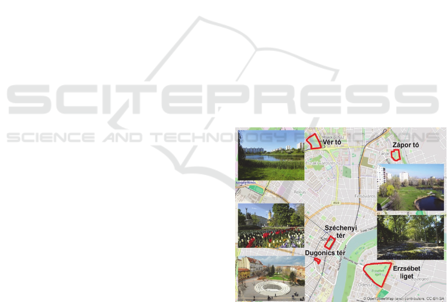
5.1 Study Areas
The research was conducted in the city of Szeged,
Hungary. Arching across the River Tisza, Szeged is
situated in south-east Hungary and serves home for
160,000 urban dwellers. Numerous green spaces of
the city contribute to the improvement of the
citizens’ QoL. The diversity of the studied parks was
a main concern of the research to ensure the
objective and subjective environmental
heterogeneity. Five green spaces have been chosen
accordingly for study areas of the thesis.
Erzsébet liget (ER) located in the vicinity of the
city centre is a relatively large, 21 ha, area with a
high proportion of vegetated surfaces including
mainly lawn and wooded areas. The park is visited
by recreational users of all age groups, from all over
the city. The recently renovated Dugonics tér (DU)
is situated in the city centre, and nearly half of its
size is vegetated. Széchenyi tér (SZ) is the attractive
main square of the city. More than half its size is
covered with lawn, flower beds, and a number of
trees. Both DU and SZ are located in
neighbourhoods consisting of pleasant late-19
th
and
early-20
th
century architecture. Whilst SZ mostly
serves as refuge and aesthetic enjoyment for locals
and tourists, DU functions as an important
pedestrian transit area. At the edge of the city, Vér tó
(VE) boasts a large lake and houses a hill at its
eastern edge. VE is surrounded by 5-10 storey
residential housing and suffers from serious noise
pollution due to nearby traffic. Similar to VE, Zápor
tó (ZA) is surrounded by residential blocks and has a
pond located in its centre. An important aspect in
which ZA is rather different from VE is that its quiet
environment serves as a tranquil resting area for its
visitors. Figure 1 pictures the location of the study
areas within Szeged.
Figure 1: Study areas.
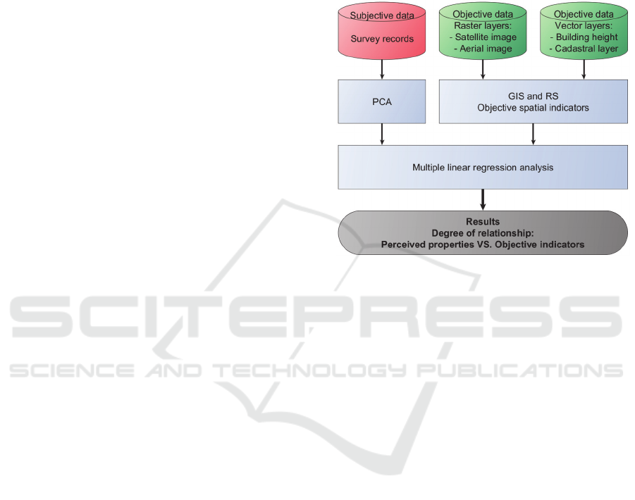
5.2 Methodology 1
As described in Section 3.1, this study seeks for the
relationship between human perception of urban
green spaces and their spatially explicit
environmental indicators. To achieve this aim the
following study was conducted.
DCSMARTGREENS 2016 - Doctoral Consortium on Smart Cities and Green ICT Systems
30
5.2.1 Used Datasets
Perceptual (subjective, qualitative) data:
Records of a questionnaire survey campaign in
the study areas.
Spatial (objective, quantitative) data:
Raster data: 2 m ground resolution Multispectral
bands of Pléiades satellite imagery of Szeged
(Astrium et al., 2014) to derive Normalized
Difference Vegetation Index (NDVI); 10 cm
ground resolution colour aerial image of Szeged
(DPGG, 2011) to delineate vegetated areas and
water surfaces of the green spaces.
Vector data: Building height layer of Szeged
(Sümeghy et al., 2011); Cadastral layer of
Szeged.
5.2.2 Description of Methodology
A questionnaire survey campaign was conducted in
the five UGS of Szeged, in April and May 2014, to
explore visitors’ subjective evaluations on objective,
spatially describable attributes of the studied areas.
The topics of the survey were the “Personal
judgement of the area”; the “Perceived greenness of
the UGS”; the “Accessibility”; and finally the
“Functions of the area”. Two hundred and fifty five
questionnaires were collected. After validation 227
answers supplied the subjective, perceptual data for
the research.
Area of the park grounds, water surfaces and
vegetated areas of the green spaces were digitised
from the aerial image to vector layers. An NDVI
image was generated form the multispectral bands of
the Pléiades satellite scene.
Applying geographical information systems
(GIS) and remote sensing technology (RS) the
following spatial indicators were calculated for each
green space based on the available objective data:
Area of the parks (ha); Area of vegetated surfaces
(ha); Percentage of vegetated surfaces (%); Area
weighted NDVI for the parks; Percentage of water
surfaces (%); Number of building units in a 50 m
buffer zone around the parks; Percentage of built up
area in a 50 m buffer zone around the parks (%);
Average building height in a 50 m buffer zone
around the parks; Standard deviation of building
heights in a 50 m buffer zone around the parks.
During a principal component analysis (PCA),
performed on the questionnaire data, three subjective
assessment dimensions were identified: Impression
of green, healthy and recreational environment;
Impression of the state of the park and Assessment
of accessibility of the park by private or public
transport. The subjective assessment dimensions,
representing visitor’s perception on the studied
UGS, and the objective data were tested against each
other with multiple regression analysis to seek for a
correlation and the degree of the relation between
the two inherently different information domains.
Figure 2 demonstrates the workflow of the first tier.
Figure 2: The workflow of Tier 1.
The results of the analysis are explained in
Section 6.1.
5.3 Methodology 2
5.3.1 Used Datasets
Perceptual (subjective, qualitative) data:
Questionnaire survey on perceived services of
the studied five urban green spaces of Szeged.
Crowd-sourced voluntary information on actual
usage and aesthetic appreciation of the study areas:
Crossing and tangential running paths uploaded
to online recreational applications, Futótérkép
and Runtastic (www.futoterkep.hu;
www.runtastic.com);
Photos from Panoramio, 360cities, Flickr and
Instagram picturing aesthetic appreciation and
recreational use of the five green spaces
(www.panoramio.com, www.360cities.net,
www.flickr.com and www.instagram.com).
5.3.2 Description of Methodology
The questionnaire data, described in Section 5.2.1
and Section 5.2.2, also incorporated information on
the perceived services provided by the five studied
parks. The answers for the questionnaires were
Multidimensional Relation of Urban Dwellers and Green Spaces
31
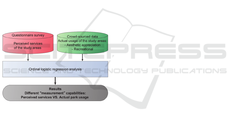
collected through a 1 to 5 Likert scale. The scores
reflect on green space users’ assessment of the
quality of recreational and infrastructural services of
the parks, as well as the subjective (perceived)
capacity of the five urban green spaces to mitigate
natural and human generated environmental
nuisances. As this information reveals individually
different opinions of survey participants it is rather
subjective. Therefore it reflects perceived, though
still crucially important, properties of the study
areas. Since the actual park usage and aesthetic
appreciation cannot be revealed by questionnaire
surveys the addition of this information is crucial for
urban planning and public space management.
To complement perceived information with data
on real park usage, the running paths crossing or
touching the park grounds were collected from the
Futótérkép and the Runtastic recreational crowd
services. For the assessment of recreational and
aesthetic use of the parks geo-located photos taken
and uploaded by users of the five public spaces were
downloaded from Panoramio, 360cities, Flickr and
Instagram photo sharing services.
Figure 3: The workflow of Tier 2.
The downloaded photos were individually
studied and classified into seventeen categories each
representing different aspects of the aesthetic
appreciation and recreational use of the green
spaces. The number of running paths will be
summed for each park in the next phase of the
second tier. The number of running paths and the
number of images per classes will provide real park
usage information and demonstrates the popularity
and suitability of the studied urban green spaces for
recreational and aesthetic purposes.
The survey records, the number of running paths
and the number of images per classes will be input
for an ordinal logistic regression analysis. The
analysis is expected to reveal the different
“measurement” capabilities of the perceived services
of the parks collected through the survey, and the
green space visitor generated actual usage of
aesthetic and recreational benefits from the study
areas. Figure 3 demonstrates the workflow of the
second tier of the thesis.
5.4 Methodology 3
5.4.1 Used Datasets
Stereo scene of the panchromatic band of the
Pléiades satellite imagery;
Normalized Difference Vegetation Index derived
from the multispectral product of the Pléiades
satellite imagery;
Enumeration district level, tabular format census
data of Szeged sourced from the 2011 Census of
Hungary;
Vector layer of census enumeration districts of
Szeged;
OpenStreetMap road network of Szeged.
5.4.2 Description of Methodology
Digital surface model (DSM) of the city of Szeged
will be generated from the stereo scene of the
Pléiades satellite imagery. The DSM will be used to
detect object heights within the satellite scene. The
vegetation within the scene will be indicated by the
NDVI product.
Using object heights and NDVI values, the
vegetation will be identified and classified into three
levels of vegetation height classes using object based
image analysis (OBIA) methods:
Low vegetation (e.g. lawn);
Middle height vegetation (e.g. bushes);
High vegetation (tree canopy).
The High vegetation class will indicate tree cover.
As green spaces with tree canopies have the highest
societal value, this class will be used for the further
analysis. Families with children and elderly citizens
have an increased demand on green space
availability. The method, being elaborated in Tier 3,
will provide a solution for calculating green space
deprivation based on demographic data and real
distances measured on the road network.
Records of the tabular format census data will be
joined to the corresponding enumeration polygons of
the Szeged enumeration district vector layer.
Number of children, their family members and
elderly citizens in each enumeration district will be
calculated based on the demography sensitive
variables of the census records (e.g. “Households by
DCSMARTGREENS 2016 - Doctoral Consortium on Smart Cities and Green ICT Systems
32
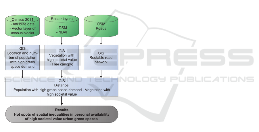
household composition and by the age composition
of household members, 2011”; “Families by family
composition and by the number of children living in
the family, 2011”; etc.). By applying this method
census blocks with high proportion of children
and/or elderly citizens will be geographically
identified.
In the next step, routable road network of Szeged
will be generated from the OpenStreetMap data.
Using the road network, walking distances to the
closest vegetation patch with “high societal value”
will be calculated for polygons of each enumeration
district. By using the walking distances to high
societal value vegetation patches, and the number of
people with high green space demand within the
enumeration districts, hot spots of spatial
inequalities in personal availability of urban green
spaces of Szeged will be identified. Figure 4
demonstrates the workflow of the second tier of the
thesis.
Figure 4: The workflow of Tier 3.
6 EXPECTED OUTCOME
The general expected outcome of the thesis is an
improved knowledge on the multidimensional
relation between urban dwellers and green spaces.
This outcome is expected to be achieved through the
results from the three tiers of the work. The expected
outcomes of the three studies are described in this
section.
6.1 Outcome 1
The multiple regression analysis, applied in the first
tier, found two minor and two mediocre correlations
between the perceived properties and the ten
objective spatial attributes of the studied green
spaces. The study concluded that there is a weak
relation between subjective and objective, spatially
explicit, attributes of urban green spaces. Therefore
the work proposes a combined use of perceptual
information and spatially explicit data for green
space planning and management.
6.2 Outcome 2
First, the results from Tier 2 are expected to unveil
the potentials of park visitor generated crowd-
sourced information to provide quantifiable input
data on actual use of aesthetic and recreational
services of urban green spaces. Secondly, the
statistical test is supposed to prove that questionnaire
surveys, as the most common sources of perceptual
information, and actual park usage reveal different
aspects of societal benefits visitors derive from
urban parks. Therefore, the tier will propose the
addition of crowd-sourced park usage information to
the results of questionnaire surveys to provide a
more comprehensive input for decision making
processes. The research warns: only the application
of both information domains can ensure thorough
and informed urban development and management
practices.
As questionnaire surveys are often conducted by
urban governments and crowd-sourced data is
readily available online, the introduced methodology
has a high transferability to further study areas
regardless of environmental settings.
6.3 Outcome 3
The methodology, applied in Tier 3, will identify the
spatial location of demographic groups of urban
population with high green space demand. More
importantly, the tier reveals real distances between
the identified groups of Szeged’s population and
urban green spaces with high societal value. By
achieving this, hot spots of spatial inequalities in
personal availability of high societal value urban
green spaces of Szeged will be identified.
Although the method introduced in this research
is highly transferable to other cities, the
demographic development of the society is constant
in time and space. To overcome this difficulty, the
more frequently available micro-censuses or mid-
year population estimates can also be used for the
described analysis rather than relying solely on less
frequent census data. Thereby, the adaptability of the
Multidimensional Relation of Urban Dwellers and Green Spaces
33

methodology to other urban environments can be
ensured.
7 STAGE OF THE RESEARCH
This PhD research is planned to last for four years.
The work was started in October 2013 and is
planned to be finished by September 2017.
The first tier of the work has been fully
elaborated and written up for publication in an ISI
ranked journal, Urban Forestry & Urban Greening.
The manuscript was accepted with major revisions.
The revisions have already been carried out. The
revised draft will be read by co-authors and proof-
readers, and then it will be resubmitted by April
2016.
Research associated to the second tier of the
thesis is being conducted at the moment. Green
space user generated, voluntary information on
aesthetic and recreational use of services generated
by the study areas have been collected from crowd-
sourced recreational and content sharing
applications. At the moment, February 2016, images
picturing aesthetics of the five green spaces are
being evaluated. The analysis of running paths will
be carried out in March and April 2016. The
statistical analysis will take place in May, then the
course of the work and the results will be written up
for an ISI ranked journal article. The draft is
expected to be submitted in the third quarter of
2016.
The work related to the third tier has already
been planned. Practical work accomplished so far is
that point cloud data has been retrieved from the
stereo pair of Pléiades satellite imagery for DSM
extraction. Secondly, routable road network of
Szeged has been generated form OpenStreetMap
data. At the moment, access to census data is being
negotiated with the Szeged Branch of the Hungarian
Central Statistical Office. The research is expected
to being accomplished in the third and the fourth
quarters of 2016. The work and its results will be
written up for an ISI ranked journal article parallel to
the research. The manuscript will be submitted in the
first quarter of 2017.
The recent state of the entire PhD thesis is
approximately thirty percent of completeness.
ACKNOWLEDGEMENTS
This research was jointly funded by the Austrian
Science Fund FWF through the Doctoral College
GIScience (DK W 1237-N23) and the University of
Salzburg.
REFERENCES
Astrium, CNES & Airbus Defence and Space 2014.
Pléiades Satallite Imagery. Toulouse, France: Astrium,
and Airbus Defence and Space.
Bowler, D. E., Buyung-ali, L., Knight, t. M. & Pullin, A.
S. 2010. Urban greening to cool towns and cities: a
systematic review of the empirical evidence.
Landscape and urban planning, 97, 147-155.
DPGG 2011. Szeged Ortofotó 2011. Szeged, Hungary:
University of Szeged, Department of Physical
Geography and Geoinformatics (DPGG).
Fontana, S., Sattler, T., Bontadina, F. & Moretti, M. 2011.
How to manage the urban green to improve bird
diversity and community structure. Landscape and
Urban Planning, 101, 278-285.
Germann-chiari, c. & seeland, k. 2004. Are urban green
spaces optimally distributed to act as places for social
integration? Results of a geographical information
system (gis) approach for urban forestry research.
Forest policy and economics, 6, 3-13.
Irvine, K., Warber, S., Devine-Wright, P. & Gaston, K.
2013. Understanding urban green space as a health
resource: a qualitative comparison of visit motivation
and derived effects among park users in Sheffield, UK.
International Journal of Environmental Research and
Public Health, 10, 417-442.
Kaźmierczak, A. 2013. The contribution of local parks to
neighbourhood social ties. Landscape and Urban
Planning, 109, 31-44.
Lee, A. C. K. & Maheswaran, R. 2011. The health benefits
of urban green spaces: a review of the evidence.
Journal of Public Health, 33, 212-222.
Sümeghy, Z., Gál, T. & Unger, J. 2011. Szeged 3d
Városmodellje. Geodézia és Kartográfia, 63 (1), 13-
16.
Tallis, M., Taylor, G., Sinnett, D. & Freer-Smith, P. 2011.
Estimating the removal of atmospheric particulate
pollution by the urban tree canopy of london, under
current and future environments. Landscape and
Urban Planning, 103, 129-138.
DCSMARTGREENS 2016 - Doctoral Consortium on Smart Cities and Green ICT Systems
34
