
The Computational Research on the Ancient near East
(CRANE) Project: An Archaeological Data Integration, Simulation
and Data Mining
Stephen Batiuk
1
, Tim Harrison
2
, Lynn Welton
3
, Darren Joblonkay
2
and Lemonia Ragia
4
1
Department of Near & Middle Eastern Civilizations and the Archaeology Centre of the University of Toronto, Canada
2
Department of Near and Middle Eastern Civilizations University of Toronto, Canada
3
The Oriental Institute, The University of Chicago, U.S.A.
4
Geneva School of Economics and Management/Information Science Institute & University Center of Informatics
(CUI)/Institute of Services Sciences, University of Geneva, Switzerland
Keywords: Data Mining, Archaeological Database, Data Analysis, Spatial Analysis, Information Retrieval, Simulation
Modelling.
Abstract: Archaeology has emerged as one of the most dynamic and innovative disciplines in the humanities and social
sciences, employing a truly interdisciplinary, collaborative approach and a continually expanding array of
analytical research tools. Computer aided analysis of archaeological data is remarkably challenging given the
heterogeneous nature of the material. Archaeologists generally aim to discover patterns, spatial relationships
and other associations between different traits of the archaeological record. However, given the idiosyncratic
and highly personal nature in which archaeological data is collected and analyzed, identifying these patterns
and relationships offers many challenges. The Computational Research on the Ancient Near East (CRANE)
initiative seeks to build an international multidisciplinary research collaboration, comprised of archaeologists,
computer scientists, and paleo-environmental specialists, with the capacity to leverage a burgeoning corpus
of data from a number of archaeological sites and fundamentally transform our knowledge of the civilizations
of the ancient Middle East. The CRANE initiative is developing a sustainable, scalable, user-driven vehicle
for large-scale data management and cross-project data integration, to harness the full evidentiary range
produced by this uniquely rich cultural legacy. At the same time we are developing tools for data mining
techniques, and to analyze simulate ancient societies using agent-based models of behavior.
1 INTRODUCTION
Over a century and a half of archaeological research
in the Near East has documented the emergence of the
first sedentary communities, the origins of
agriculture, the development of the first state-level
societies, and the first interregional commercial and
political networks (Redman, 1978; Wilkinson, 1994;
Akkermans and Schwartz, 2003; Yoffee, 2005; Edens
and Kohl, 1993; Marfoe, 1987; Stein and Blackman,
1993; Wattenmaker, 1994; Wattenmaker, 1998a;
Wattenmaker, 1998b; Mazzoni, 2003). Yet its
contribution to a deeper understanding of the long-
term growth and development of human communities
and their interaction with the natural environment has
been hindered by a less-than-ideal publication record
and the lack of any real analytical framework that
incorporates the full array of data produced by this
uniquely rich cultural legacy. Furthermore, the
present wars in Syria and Iraq have left the
completion of many projects impossible for the
foreseeable future, further hindering final
publications, leaving data sets in limbo.
Advances in the collection and analysis of
archaeological data mean that, in many respects, we
have never been in a better position to pull together
the often heterogeneous and idiosyncratic published
and unpublished datasets, and understand the nature
and scope of these social, political, economic, and
ideological transformations in the ancient world
(Kansa, 2005; Kansa, 2010; Kansa et al., 2005;
Kansa et al., 2007; Petrovic et al., 2011). Yet such
efforts are often hampered by the challenges of
integrating the datasets (which are often at varied
Batiuk, S., Harrison, T., Welton, L., Joblonkay, D. and Ragia, L.
The Computational Research on the Ancient near East (CRANE) Project: An Archaeological Data Integration, Simulation and Data Mining.
DOI: 10.5220/0006213401530160
In Proceedings of the 3rd International Conference on Geographical Information Systems Theory, Applications and Management (GISTAM 2017), pages 153-160
ISBN: 978-989-758-252-3
Copyright © 2017 by SCITEPRESS – Science and Technology Publications, Lda. All rights reserved
153
spatial and temporal scales) which would be capable
of resolving short term actions or long term processes
spanning the millennia of data we have in the Ancient
Near East.
Large-scale data analysis has become increasingly
common in humanities scholarship, with researchers
increasingly disappointed by the impoverished results
they receive when querying multiple datasets that
have only superficially shared data structures, an all
too familiar problem when using internet search
engines such as Google. The poor quality of large-
scale query results, typically of textual data, reflects
the difficulties inherent in machine processing of
natural language and other kinds of ‘artificial
intelligence’ (Abiteboul et al., 2000; Ling and
Dobbie, 2004; Dreyfus, 1992). The Computational
Research on the Ancient Near East (or CRANE)
Project, directed by Tim Harrison of the University of
Toronto and funded primarily by the Social Sciences
and Humanities Research Council of Canada, is an
international collaboration that takes up these
challenges through the integration and analysis of
data from a number of archaeological projects
working within the Orontes Watershed of modern
Southeastern Turkey and Northwestern Syria.
The underlying rationale for the CRANE Project
is to build an international collaboration of
researchers who will leverage these data to model and
visualize the interplay of social, economic and
environmental dynamics at various spatial and
temporal scales in order to shed light on the rise and
development of complex societies in this important
region. This research will also provide insight into a
number of pressing contemporary issues, including
the ecological impact of human activities, the
socioeconomic and political impact of climate
change, the long-term health consequences of human
dietary practices and subsistence strategies, and the
role of cultural conflict in affecting social and
political change.
The work of the CRANE Project is guided by a
number of specific research objectives, including the
integration of digital data from multiple
archaeological research projects - both legacy and
active - that use different terminologies stemming
from different research traditions and
methodologies; the development of a core cultural,
paleo environmental and chronological sequence for
the Orontes Watershed; the creation of protocols and
analytical tools to facilitate broad access to this
information; the modeling of emergent and inverse
simulations of ancient social practices and related
human-environment dynamics based on parameters
supplied by empirical data; the creation of spatially
accurate and realistic 3D visualizations of
reconstructed ancient landscapes and human activity
based on empirical data and the output of simulated
scenarios; the creation of research opportunities and
training in advanced archaeological analysis for
university students at all levels and junior scholars.
2 THE ORONTES WATERSHED
In its current stage, the CRANE Project is addressing
these objectives through a focus on the Orontes
Watershed in southeast Turkey and northwest Syria.
The Orontes valley represents the northern most
extension of the Greta Rift Valley, and is dominated
by the Orontes river, which finds its headwaters in the
Lebanese mountains, flowing north reaching the
Mediterranean Sea in the Hatay region of south
Eastern Turkey, which is in turn fed by a hydrological
system fed from as far north as the Maraş plain,
encompassing a drainage basin of around 24,000 km
2
(Fig. 1).
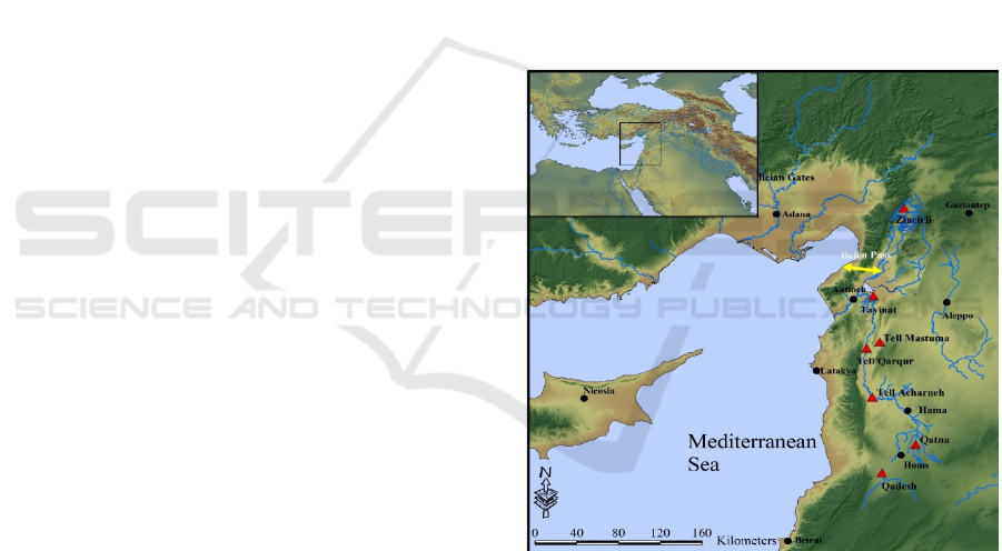
Figure 1: The Orontes Watershed.
Over a century and a half of archaeological survey
and excavation throughout this region has brought to
light one of the most important cultural sequences in
the ancient Near East. As a cohesive geographical
unit and a cultural microcosm of the broader Near
East, it represents an exceptional initial test case. Our
present efforts are concentrating on the integration of
data from five important sites in this region, Tell
Acharneh, Tell Nebi Mend, Qatna, Tell Tayinat and
Zinçirli Höyük, as well as a number of archaeological
surveys, and is presently set to expanding to include
other sites in the greater region. These projects
GISTAM 2017 - 3rd International Conference on Geographical Information Systems Theory, Applications and Management
154
represent a diverse set of not only of archaeological
data, but excavation and recording methodologies,
different taxonomies for the collected data, in which
the level of detail and quality of the data varies greatly
within the individual projects, let alone between the
projects.
2.1 OCHRE Data Integration
Data integration is an essential component of CRANE
and presents a significant challenge in trying to
incorporate the heterogeneous datasets from various
projects into a single query able environment without
imposing a uniform taxonomy. Archaeological data
can be quite diverse and significantly variable;
including architectural, artefactual, or ceramic data,
which can be represented by drawings, photos,
vector, or textual data of measurements and/ or
descriptions. Furthermore this data is highly
interpretive, which can change over an excavation
season, with post-excavations analysis, or with
changes in theoretical approaches, all of which must
be coherently documented. Making meaningful links
between these disparate datasets is an immense
challenge, and one that can only be undertaken with
The Present Advances in Computing. the Collection
of This Data in a Centralized Networked Legacy
Protected Location Allows for the Preservation of the
Record of Archaeological Excavations in an
Electronic Format for Present and Future Scholars or
Even Eventually the Public to Utilize.
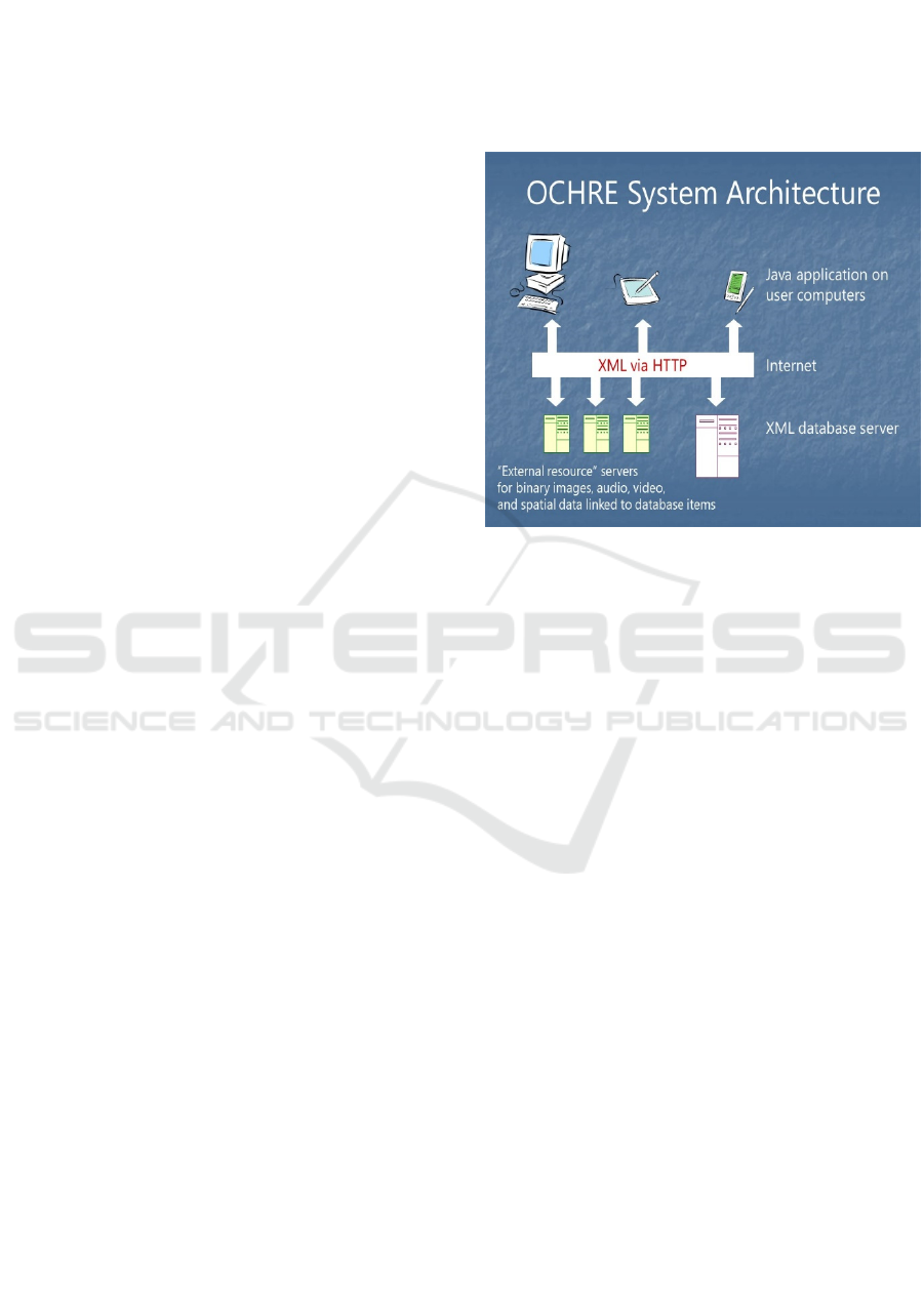
to Meet This Challenge, Our Current Data
Integration Efforts Focus on the Use and
Enhancement of the Online Cultural and Historical
Research Environment, or OCHRE, a Powerful,
Multi-User, XML Database System Developed by
David and Sandra Schloen of the University of
Chicago (Schloen 2001). in the Figure 2 the OCHRE
System Architecture Is Presented. OCHRE’s Item-
based Approach Is Highly Flexible, and as Relatively
Few Concepts and Relationships Are Predefined, It
Enables It to Operate at a Much Higher Level of
Abstraction than Formal Ontologies Employed by
Other Such Data Frameworks. Its Generic Ontology
Is Also Inherently Extendible, Allowing CRANE
Researchers to Construct Their Own Lists and
Hierarchies of Data Items, and Their Own
Taxonomies to Describe Those Items, but More
Important for Us Allows Us to Create Thesauri to
Link Equivalent Categories across Participating
Projects. OCHRE Displays and Manages Data Items
Spatially through the Use of an Embedded Java SDK
by ESRI Which Allows for the Full Visualization of
All Data Housed within the Database. CRANE Is
Collecting and Integrating Data from the Orontes
Region at an Unprecedented Level and Developing
New Tools to Leverage These Data. Modern Data
Mining, Modeling/Simulation and Visualization
Techniques Are Being Used to Transform the Data
into Information That Helps Researchers Better
Understand What Happening in the Region in the past
and Present It in More Meaningful Ways to the
General Public.
Figure 2: The OCHRE System Architecture.
2.2 Crane Subprojects
The over-arching nature of CRANE results in a
number of inter-related sub projects. What follows is
a brief description of a few of the relevant subprojects
that focus on Geographical Information Systems. For
a full description of the various CRANE subprojects
and how they are integrated, see (CRANE 2016). One
of the primary projects initiated was a comprehensive
inventory of all sites identified in the Orontes
Watershed to serve as a backbone to the project, a
scaffold upon which many of the sub-projects hang.
We presently have identified over 4100 sites in the
greater Orontes region, delineated by their geographic
location, chronological periods, linked to an
exhaustive bibliography. OCHRE’s API Integration
with the French PaleoSyr Project (ANR-PALEOSYR
2014), has given us access to an incredible array of
additional data for the various sites, including
descriptive, chronological and other archaeological
metadata. These data have been shared with ASOR’s
Cultural Heritage Initiative (ASOR 2014) – to aide in
the construction of a more comprehensive database
of sites in Syria and Iraq to help with management of
the destruction of Cultural heritage monuments from
the civil wars in the region. Integrating remotely
sensed imagery, historical maps of the regions, along
with thematic maps (including soil, geology,
hydrology, elevation and slope etc) were all
The Computational Research on the Ancient near East (CRANE) Project: An Archaeological Data Integration, Simulation and Data Mining
155
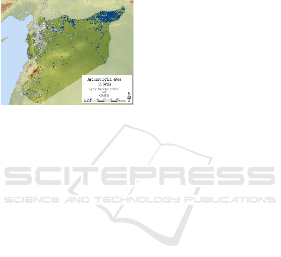
integrated into OCHRE, and utilizing the GIS
capabilities of OCHRE (Fig. 3).
Figure 3: A map with GIS.
2.3 Simulation Modeling
One important objective of the CRANE project was
to ultimately be able to utilize the various assembled
georeferenced archaeological and environmental
datasets from within the Orontes watershed to
examine human-environment interaction through the
modeling of both natural systems and social
processes, as well as investigate the interplay and
interaction between these two sets of variables in
contributing to emergent social complexity.
As a result, a secondary sub-project developed as
part of CRANE was to implement a program of agent-
based simulation modelling built on an earlier
research initiative entitled “Modeling Ancient
Settlement Systems” (Wilkinson et al., 2007), which
used holistic agent-based simulation techniques to
explore socio-ecological questions in ancient
Mesopotamia. Agent-based modelling is used to
simulate the emergence and functioning of complex
systems through the actions and interactions of
autonomous agents, who are programmed to behave
according to certain defined rules. These agents can
either be individuals, or can represent collective
entities such as organizations or groups. While it has
been more consistently used in other fields such as
computational sociology and ecology, it has not been
frequently applied to archaeological questions. The
ways in which the results of agent-based modelling in
archaeology have been interpreted in the past have
been problematic, sometimes leading its value to the
discipline to be misconstrued. The outcomes and
goals of simulation modeling have often been
conceptualized in terms of the idea that the ultimate
goal of an agent-based model is simply to run it and
have it approximate reality as closely as possible, and
therefore that its ability to do so represents its ultimate
value to archaeology. When the endeavour is viewed
this way, the criticisms are obvious; it is impossible
to account for every single possible factor that could
affect the outcomes of processes in complex systems
like ancient societies, and the idea that we can
adequately account for random variation is also
problematic.
The outputs of computer-based simulations can be
compared to the archaeological record, but this is
generally best done as a means of testing specific
hypotheses about explanations for the appearance or
behaviour of certain phenomena and the investigation
of new research avenues (for a recent attempt in
biomedicine, see Kammash, 2008). ENKIMDU is a
modeling framework with the capability to create a
virtual world in which to run simulations based on
various environmental and social parameters
(Christiansen, 2005; Christiansen and Altaweel
2006a; Christiansen and Altaweel, 2006b).
ENKIMDU’s approach is holistic and agent-based,
and represents a “bottom up” method of modeling.
This means that its simulated historical trajectories
appear as the cumulative outcomes of a host of small-
scale activities and interactions, for instance as a
result of actions by individual persons, households,
crop fields, and domesticated animals. ENKIMDU
was developed with the intention of testing the idea
that the appearance of urban centres in Mesopotamia
was an emergent phenomenon that was ultimately
regulated by positive feedback loops that encouraged
population agglomeration and settlement growth, and
negative feedback loops that constrained growth and
kept it within certain limits.
For much of its environmental modelling,
ENKIMDU relies on communicating with third-party
software called SWAT, the Soil and Water
Assessment Tool, developed jointly by the USDA
Agricultural Research Service and Texas A&M
University (Neitsch et al., 2002; Arnold and Fohrer,
2005). This software was developed to model a
variety of natural processes, such as basic weather
patterns, hydrology (including surface runoff and
water table dynamics), soil evolution and erosion,
plant nutrient cycling, and vegetation growth
(including both the natural environment and human-
managed crop growth). SWAT’s internal weather
generation abilities are augmented by using ClimGen,
a Markov-chain weather generator (Stöckle et al.,
1999). This SWAT-based environmental model is
then positioned in a larger social model, whose
original focus was on subsistence economy,
agricultural processes and sustainability in relation to
GISTAM 2017 - 3rd International Conference on Geographical Information Systems Theory, Applications and Management
156
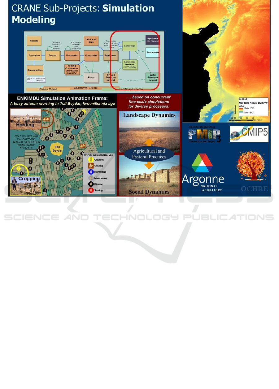
Figure 4: The simulation modelling.
environmental conditions and the demographic
structure of the population. The model focused on the
performance of detailed aspects of the agricultural
cycle, including planting, irrigation, harvesting, crop
processing, storage and consumption (Fig. 4).
Although the ENKIMDU model creates individual
people as agents, the primary decision-making social
agent for agricultural processes is the Household.
Households can allocate labor and other resources,
and plan both short-term and long-term agricultural
operations. Households can also identify situations of
short-term, medium-term and long-term food stress,
and deploy a variety of different coping strategies for
dealing with each of these situations.
Another important area of CRANE’s interest has
been in the implementation of paleoclimate
modelling using General Circulation Models, in
particular, the models of the Coupled Model
Intercomparison Project (Taylor et al., 2011) and the
Paleoclimate Modelling Intercomparison Project
(Argus and Peltier, 2010; Tarasov et al., 2012;
Lambeck et al., 2010).
These projects model various climate-related
variables both forward and backward in time,
including temperature and precipitation, but also a
host of other factors relating to issues like ocean
currents and temperatures, wind patterns, snow
coverage, and vegetation patterns. CMIP5’s standard
modelling time frames include 6kya (the mid-
Holocene, ca. 4000 BC), while PMIP runs
experiments for additional time frames including the
Early Holocene and the 8.2 kya climatic event (ca.
6200 BC).
2.3 Data Mining
Archaeologists are frequently pursuing new
techniques and tools to analyze their data. In an effort
to identify relationships for interpretation, they have
utilized a number of different approaches. Data
analysis and information retrieval is explicitly
described in Richards and Ryan, 1985. Statistics is
not a new topic for archaeology and is extensively
analyzed by Kimball 1997. The differences between
qualitative and quantitative analysis is also covered
using examples in Drennan, 2008. In another
approach it is explained how statistical techniques can
clarify ambiguous patterns in an historical application
(Kelly-Buccellati and Elster, 1973). It is
The Computational Research on the Ancient near East (CRANE) Project: An Archaeological Data Integration, Simulation and Data Mining
157
demonstrated that the application of statistical
thinking and techniques can aid the archaeologist in
retrieving as much information as possible from
artifacts (Bentley and Schneider, 2000).
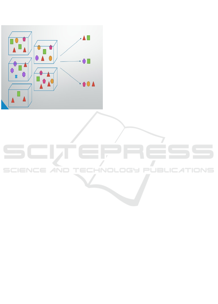
Figure 5: A diagram with association rules.
Data mining is a scientific topic of information
technology widely used in many applications.
Handling different data types data mining techniques
result in automatic knowledge discovery and decision
support (Han et al. 2011), (Olson and Delen
2008). The association rules establish relationships
between variables in a given data set. Mining
association rules were first introduced in Agrawal et
al. 1993. Since then they received much attention in
academic and industrial applications (Jiao, et al.
2006).
There is an approach deals with data mining
techniques on heterogeneous archaeological
databases on smaller scales to that of CRANE
(Zweig, 2006). Data mining techniques have been
also used for historical manuscripts and cultural
artifacts (Zhu, 2011). It has been proposed the
application of Association Mining algorithms (in
particular an updated form of the Apriori algorithm as
initially conceived by Agrawal et., 1993), in order to
reveal heretofore unrecognized associations between
artifacts in archaeological contexts, as itemized in
archaeological data warehouse environments, such as
OCHRE. The Apriori algorithm is utilized to detect
those items (i.e. artifacts) which are frequently
associated with one another in context, the
relationships between which are indicative of past
commonly attested practices within the community
under analysis. The output results in a series of
association “rules” (lists of the frequency with which
items are found together in context), which may be
graphed to provide a visual representation of the past
organization/structure of a community (Fig. 5). The
methodology has been applied to a small Iron Age
settlement (ca. 9th century BCE) in northwest Syria,
in order to produce a more nuanced characterization
of the community, based upon commonly attested
practices amongst households at the site.
The archaeological data are described by
attributes with their values. A value can be numerical
and non-numerical. An attribute is an individual
characteristic of an artifact which represents the
archaeological finding. In our sample the artifact is an
item and can be further subdivided by its attributes.
The attributes have non-numerical values describing
different traits such as color, texture, form, shape. As
an example the attribute form can have as values
"Bowl", "Cooking Pot" or "Store Jar". Relationships
between variables can be found using logical
operations as an expression. The items are discovered
in different location of the excavation and the whole
excavation area is split into 11 rooms. There is also
an attribution based on a spatial relationship
representing the location of the items. The location of
the item is defined by the value "Room" with its
number, e.g. "Room 5". The spatial relationship
"included_by" can also be used to identify the
location.
3 CONCLUSIONS
The rapid proliferation of digitally generated
archaeological data (both new and digitized legacy
data) represents a profound opportunity for our
discipline to contribute meaningfully to issues of
pressing contemporary concern, while providing
deeper insight and understanding about the world in
which we live. However this can only be achieved
through the development and utilization of robust
computational tools. Near Eastern Archaeology
represents an ideal test case for developing a
computational framework capable of integrating the
complex, heterogeneous, or “messy”, datasets that
typify our world, and defy the homogenizing
algorithms of machine-driving learning. Thus, the
most successful collaborative data-sharing ventures
in this effort are likely to be those that accommodate
multiple, diverse taxonomic structures and
hierarchies of knowledge and meaning. To ensure the
full exploitation of these datasets by both
archaeologist as well as public stakeholders (such as
Cultural Heritage Management Groups), more
powerful tools that maximize the potential of the
computational tools available to us today.
GISTAM 2017 - 3rd International Conference on Geographical Information Systems Theory, Applications and Management
158

ACKNOWLEDGEMENTS
We wish to acknowledge the very real collaborative
contribution of our CRANE colleagues, from
universities worldwide, as well as non-academic
partners. A special thanks goes out to our
hardworking students who play an integral role in the
success of our work, and finally the generous support
of the Social Sciences and Humanities Research
Council of Canada who makes all the work possible.
REFERENCES
Abiteboul, S., Buneman, P., and Suciu, D., 2000. Data on
the Web: from relations to semistructured data and
XML. Morgan Kaufmann.
Agrawal, R., Imieliński, T., and Swami, A., 1993, June.
Mining association rules between sets of items in large
databases. In Acm sigmod record, Vol. 22, No. 2, 207-
216. ACM.
Akkermans, P.M.M.G. and Schwartz, G.M., 2003. The
Archaeology of Syria: From Complex Hunter-
Gatherers to Early Urban Societies (ca. 16,000-300
BC). Cambridge: Cambridge University Press.
ANR-PALEOSYR 2014
http://www.archeorient.mom.fr/recherche-et-
activites/appels-d-offre-et-contrats/ANR-PALEOSYR
Argus, D. F. and Peltier, W. R., 2010. Constraining models
of postglacial rebound using space geodesy: a detailed
assessment of model ICE-5G (VM2) and its relatives.
Geophysical Journal International 181 (2), 697–723.
Arnold, J.G., Fohrer, N., 2005. SWAT2000: current
capabilities and research opportunities in applied
watershed modelling. Hydrological. Process. 19 (3),
563–572.
ASOR 2014. http://www.asor-syrianheritage.org/
Bentley, J., Schneider, T. J., 2000. Statistics and
archaeology in Israel. Computational statistics & data
analysis, 32(3), 465-483.
Christiansen, J.H., 2005. A Practical Approach for
Constructing Flexible and Robust Simulations for
Complex, Heterogeneous Problem Domains. Paper
presented at the Santa Fe Institute Workshop: Next
Generation Simulations of Human-Environment
Interactions, Tucson, AZ, December 12-15, 2005.
Christiansen, J.H., Altaweel. M., 2006a. Understanding
Ancient Societies: A New Approach Using Agent-
Based Holistic Modeling. Structure and Dynamics:
eJournal of Anthroplogical and Related Sciences Vol.
1: No. 2, Article 7.
Christiansen, J. H., Altaweel, M., 2006b. Simulation of
natural and social process interactions: An example
from Bronze Age Mesopotamia. Social Science
Computer Review, 24(2), 209-226.
CRANE 2016: www.crane.utoronto.ca
Drennan, R. D., 2008. Statistics in archaeology. Pearsall,
Deborah M. Encyclopedia of Archaeology. Elsevier
Inc, 2093-2100.
Dreyfus, H.L., 1992. What Computers Still Can’t Do: A
Critique of Artificial Reason. Cambridge, MA: MIT
Press.
Edens, C.M., Kohl, P.L., 1993. Trade and World Systems
in Early Bronze Age Western Asia. In Trade and
Exchange in Prehistoric Europe. Edited by C. Scarre
and F. Healy. Oxford: Oxbow Books, 17-34.
Han, J., Pei, J., and Kamber, M., 2011. Data mining:
concepts and techniques. Elsevier.
Jiao, J. R., Zhang, Y., and Helander, M., 2006. A Kansei
mining system for affective design. Expert Systems
with Applications, 30(4), 658-673.
Kammash, M., 2008. Reverse Engineering: The
Architecture of Biological Networks. Biotechniques 44
(3):323-29.
Kansa, E.C., 2005. A Community Approach to Data
Integration: Authorship and Building Meaningful Links
across Diverse Archaeological Data Sets. Geosphere
1/2: 97-109.
Kansa, E.C, 2010. Open Context in Context:
Cyberinfrastructure and Distributed Approaches to
Publish and Preserve Archaeological Data. The SAA
Archaeological Record 10 (5): 12-16.
Kansa, E.C, Schultz, J., and Bissell, A. N., 2005. Protecting
Traditional Knowledge and Expanding Access to
Scientific Data. International Journal of Cultural
Property 12/3: 285-314.
Kansa, S.W., Kansa, E.C., and Schultz, J.M., 2007. An
Open Context for Near Eastern Archaeology. Near
Eastern Archaeology 70/4: 188- 201.
Kelly-Buccellati, M., Elster, S., 1973. Statistics in
archaeology and its application to ancient Near Eastern
data. Orientalia, 42, 195-211.
Kimball, L. R., 1997. Statistics for Archaeologists: A
Commonsense Approach. American Antiquity, 62(3),
568-570.
Lambeck, K., Purcell, A., Zhao, J., and Svensson, N.-O.
2010. The Scandinavian Ice Sheet: from MIS 4 to the
end of the Last Glacial Maximum. In Boreas, 39, 410–
435
Ling, T. W., Dobbie, G., 2004. Semistructured database
design (Vol. 1). Springer Science & Business Media.
Marfoe, L. 1987. Cedar Forest to Silver Mountain: Social
Change and the Development of Long-Distance Trade
in Early Near Eastern Societies. In Centre and
Periphery in the Ancient World, 25-35.
Mazzoni, S., 2003. Ebla: Crafts and Power in an Emergent
State of 3rd Millennium Syria. Journal of
Mediterranean Archaeology 16: 173-91.
Neitsch, S.L., Arnold, J.G., Kiniry, J.R., Srinivasan, R.,
Williams, J.R., 2002. Soil and Water Assessment Tool.
Users Manual. Version 2005. GSWRL Report 02-02,
BRC Report 2-06, Temple, Texas, USA
Olson, D. L., Delen, D., 2008, Advanced data mining
techniques. Springer Science & Business Media.
Petrovic, V., Gidding, A., Wypych, T., Kuester, F.,
DeFanti, T., and Levy, T., 2011. Dealing with
The Computational Research on the Ancient near East (CRANE) Project: An Archaeological Data Integration, Simulation and Data Mining
159

Archaeology’s Data Avalanche. Computer, 44(7), 56-
60.
Redman, C., 1978. The Rise of Civilization; From Early
Farmers to Urban Society in the Ancient Near East. San
Francisco: W.H. Freeman and Co.
Richards, J. D., Ryan, N. S., 1985. Data processing in
archaeology. CUP Archive.
Schloen, J. D., 2001. Archaeological data models and web
publication using XML. Computers and the
Humanities, 35(2), 123-152.
Schloen, J.D., Schloen S.R., 2012. OCHRE An Online
Cultural and Historical Research Environment.
Stein, G., Blackman M.J., 1993. The Organizational
Context of Specialized Craft Production in Early
Mesopotamian States. Research in Economic
Anthropology 14: 29-59.
Stöckle, C.O., Campbell G.S., Nelson R., 1999. ClimGen
Manual. Biological Systems Engineering Department,
Washington State University, Pullman, WA
Tarasov, L., Dyke, A. S., Neal, R. M., and Peltier, W.
R.,2012. A data-calibrated distribution of deglacial
chronologies for the North American ice complex from
glaciological modeling. In Earth and Planetary
Science Letters., 315, 30–40.
Taylor, K. E., Stouffer, R. J., and G. A. Meehl, G.A.,
2011. An overview of CMIP5 and the experiment
design, Bull. Am. Meteorol. Soc., 93(4), 485–498.
Wattenmaker, P., 1994. Political Fluctuations and Local
Exchange Systems in the Ancient Near East: Evidence
from the Early Bronze Age Settlements at Kurban
Hoyuk. In Chiefdoms and Early States in the Near East;
The Organizational Dynamics of Complexity. Ed. By G.
Stein and M. S. Rothman. Madison: Prehistory Press,
193-208.
Wattenmaker, P., 1998a. Craft production and social
identity in northwest Mesopotamia. Archeological
Papers of the American Anthropological
Association, 8(1), 47-55.
Wattenmaker, P., 1998b. Household and State in Upper
Mesopotamia: Specialized Economy and the Social
Uses of Goods in an Early Complex Society.
Washington: Smithsonian Institute Press.
Wilkinson, T.J., 1994. The Structure and Dynamics of Dry-
Farming States in Upper Mesopotamia.” Current
Anthropology 35: 483-520.
Wilkinson, T.J., Gibson, M., Christenson, J., Widell, M.,
Woods, C., Kouchoukos, N., and Paulette, T., 2007.
Modeling Settlement Systems in a Dynamic
Environment: Case Studies from Mesopotamia. In The
Model-Based Archaeology of Socionatural Systems.
Ed. by T.A. Kohler and S.E. van der Leeuw. Santa Fe,
NM: School for Advanced Research Press, 175-208.
Yoffee, N., 2005. Myths of the Archaic State: Evolution of
the Earliest Cities, States and Civilizations. Cambridge:
Cambridge University Press.
Zhu, Q., 2011. Data Mining Historical Manuscripts and
Culture Artifacts. UC Riverside: Computer Science.
Retrievefrom:
http://escholarship.org/uc/item/2jx150v7
Zweig, Z., 2006. Using Data Mining Techniques for
Analyzing Pottery Databases (Doctoral dissertation,
Department of Land of Israel Studies & Archaeology,
Bar-Ilan University. Ramat-Gan, Israel 2006).
GISTAM 2017 - 3rd International Conference on Geographical Information Systems Theory, Applications and Management
160
