
RouteQuizer
A Geocaching System for Educational Purposes
Vyron Ignatios Michalakis, Michail Vaitis and Aikaterini Klonari
Department of Geography, University of the Aegean, University Hill, 81100, Mytilene, Lesvos, Greece
Keywords: Geography Education, Geoinformatics, Geocaching Game, Mobile Learning, Android Smartphone.
Abstract: This article presents a geocaching educational system called RouteQuizer that consists of an Android
application, a web application and an online database. It motivates students to visit various geographic points
of interest and answer site-related questions of multiple choice type. The android application used by the
students, takes advantage of the navigation (GPS) and internet connectivity features of their smartphones. The
web application is used by tutors, to create dynamic location-based educational games for their students. The
database stores data such as site information and coordinates, questions and answers regarding the area of
interest, as well as students’ performance results. There are no geographical restrictions and no limits
regarding the number of destinations, thus making the application usable from everyone everywhere.
1 INTRODUCTION
Along with the constant development of technology,
smartphones came into our lives in the late 2000s. As
smartphones were sprawling the market, they started
replacing the old cell phones as we knew them a
decade ago.
The features of smartphones are such that,
excluding their predecessors, they replaced devices
that previously were necessary, such as alarm clocks,
cameras, radios, GPS devices, flashlights, compasses
etc. Considering they cost much less than a laptop or
a personal computer, their high portability, internet
connectivity and computational power, they are now
used for medical, military, tourist and education
purposes.
One of the main priorities set by the European
Union, in the “Education and Training 2020”
strategic framework, is “Open and innovative
education and training, including by fully embracing
the digital era”. Also, the European Union funds a lot
of mobile learning programs, such as MOTILL,
MLearn and Edumotion, in an attempt to promote the
use of smartphones in education (European Union,
2015).
Modern technology, offers more than just being
attractive to students; it also enables tutors to
implement innovative activities that could benefit the
educational process, such as geocaching.
Until now, geocaching required either maps and
photographs, or GPS devices, or even a combination
of all of them, practices that are thoroughly analyzed
and compared in (Ellbrunner, H., et al., 2014), (Jones,
T., 2012), (Hamm, B., 2010), (Vitale, J.L., et al.,
2012), (Robison, D., 2011), (Christie, A., 2007),
(Lisenbee, P., et al., 2015) and (Palmárová, V. and
Lovászová, G., 2012).
The GPS and compass features that all
smartphones now provide, increased significantly the
number of people involved with geocaching.
Smartphone applications, such as “Geocaching®” by
“Groundspeak Inc.”, mentioned in (Ihamäki, P.J.,
2012), and also “c:geo” by “c:geo team”, are
commonly used by millions of users. The fact that
geocaching is also widely used by tutors and students
for educational purposes, and that all applications
mentioned above (and other similar), do not provide
the ability to dynamically create new educational
activities, have highlighted the need for a specially
developed smartphone application, that utilizes the
new technological achievements in favor of
education.
Such an application, is presented in (Kohen-Vacs,
D., et al., 2012). Although we were not aware of the
existence of such an application, we followed a
similar direction and we created the RouteQuizer
system. RouteQuizer system consists of a database,
an Android application and a web application.
Although it shares some similarities with the
prementioned above, it differs mainly because of its
Michalakis, V., Vaitis, M. and Klonari, A.
RouteQuizer - A Geocaching System for Educational Purposes.
DOI: 10.5220/0006321203670374
In Proceedings of the 9th International Conference on Computer Supported Education (CSEDU 2017) - Volume 2, pages 367-374
ISBN: 978-989-758-240-0
Copyright © 2017 by SCITEPRESS – Science and Technology Publications, Lda. All rights reserved
367

ability to inform teachers about their students’
performance and to implement multiple choice
questions on site. Also, RouteQuizer features a
simple, yet attractive, user interface in order to get
students of all educational levels, as well as students
that have no previous smartphone experience,
involved. It motivates them, to visit monuments,
buildings, and any other point of interest as part of an
educational trip or activity, learn while playing a “lost
treasure” game, or tour the sights of a city, using their
smartphones as a teaching medium. It also provides
the tutors a web application, to create specialized
activities, that integrate geocaching and education.
1.1 Aims and Objectives
RouteQuizer was developed in order to satisfy the
following requirements:
Simple user interface, so that it can be used by
students of several educational levels;
Provide global geographic coverage;
Enable the teacher to significantly customize any
specific activity;
Provide information on the performance of each
student;
Be an attractive experience for students, spurring
their interest;
Be supported by all android operating system
versions and smartphone models;
Provide an as safer as possible experience to the
students, by making sure they will not get lost;
Manage to incorporate all the positive aspects that
the integration of mobile phones and education
can provide, whilst excluding any possible
negative consequences.
1.2 Implementation
RouteQuizer application is developed for the Google
Android operating system that is used in more than
80% of smartphones worldwide. Along with the
application, an online MySQL database was also
created, in which all the data are stored. The
programming languages that were used are java for
the application and PHP for the data exchange
between the application and the database.
In order to support the android application, a web
application was also developed, using html5
language. The website’s purpose is to enable tutors to
create or manage activities, to store all activity data
needed by the android application, and to inform
tutors with the results of the activities that were
already completed.
2 MOBILE LEARNING &
GEOCAHING
2.1 Mobile Learning
In 2011, UNESCO offered the following definition of
mobile learning; “Mobile learning is learning that
occurs in or outside of a classroom or formal
education setting, is not fixed to a particular time or
place, and is supported by the use of a mobile device.
Mobile devices range from standard mobile phones to
tablet devices and include personal digital assistants,
MP3 players, flash drives, electronic-book readers
and smartphones“ (UNESCO, 2011).
2.1.1 UNESCO Mobile Learning Policy
Guidelines
UNESCO encourages nations to adopt mobile
learning policies by following its guidelines
(UNESCO, 2013): Create or update policies related
to mobile learning; train teachers to advance learning
through mobile technologies; provide support and
training to teachers through mobile technologies;
create and optimize educational content for use on
mobile devices; ensure gender equality for mobile
students; expand and improve connectivity options
while ensuring equity; develop strategies to provide
equal access for all; promote the safe, responsible and
healthy use of mobile technologies; use mobile
technology to improve communication and education
management; raise awareness of mobile learning
through advocacy, leadership and dialogue.
2.1.2 Mobile Learning Benefits
Responding to UNESCO’s guidelines, the European
Commission, in its growth strategy “EUROPE 2020”,
in 2015, emphasized on the benefits of mobile
learning (UNESCO had also analyzed the benefits of
mobile learning since 2013), stating that ICT
(Information and Communication Technologies) is
found in many studies to motivate learners; there is
substantial evidence that ICT, if it is introduced and
used in the right way, can improve learner outcomes;
while using ICT in education, the learner also
acquires digital skills which are pivotal for living and
working in today’s society; by using different kind of
social media, in particular social networking sites,
learning can become a more participatory, life-long
process; according to available statistics, the
proportion of adults not already using internet and
social networking sites, seems to be fairly limited and
diminishing; the development of smart phones and
CSEDU 2017 - 9th International Conference on Computer Supported Education
368

computer tablets create new pedagogical challenges
and offer increased opportunities for learning at any
location.
The smartphone, being a relatively new device,
offers a boost to mobile learning, mainly because of
its high portability, low cost; especially when
compared to laptops, energy efficiency, connectivity,
personal feel, pleasant to use touch screen and
capability to access information immediately via the
internet.
2.1.3 Pedagogical Implications of Mobile
Learning
Mobile learning could be adapted to various types of
learning, such as (Jacob, S.M. and Issac. B., 2008):
Behaviourism; mobile devices can facilitate feedback
and reinforcement, when tutors and students are using
the devices in tandem. Constructivism; the rich
media, simulations and immersive environments it
demands, can be provided through mobile devices.
Informal or situated learning; mobile devices’
portability allow the use of education in all relevant
to the study of field environments. Collaborative
learning; the advanced connectivity of mobile
devices, students and tutors can create and share
resources instantly.
2.2 Geocaching Benefits
Geocaching is a modern version of the “Treasure
Hunt” game. Participants use GPS devices, and
nowadays smart phones, to hide or find geocaches
around the world. A geocache is usually a box
containing a pencil, a calendar, which is signed by
everyone that visits the geocache, and sometimes
various small collectibles.
Geocaching, has received wide popularity and
offers a wide variety of benefits. The benefits of
participating in such an activity, although they vary
depending on how one exerts such an activity are
huge. Clearly the benefits associated with the natural
state of the participant are obvious, but also the
benefits related to sociability of the participant are
many.
According to (Taylor, J.K., et al., 2010) the
benefits that geocaching provides, can be
distinguished in three main categories, physical,
social and educational benefits.
2.2.1 Physical Benefits
One of the main benefits of geocaching, is that it
requires physical activity from its participants, while
the level of fitness requirements varies, depending on
the person and geocaches selected. Also, the search
for geocaches largely develops their sense of
orientation, an important part of the process of cache-
hunting.
Regardless of the location, the distance and the
required level of fitness, the element of adventure
which is closely linked to the process of exploration,
gives a fairly high level of interest which also has its
own benefits. Besides the above, the benefits of the
process are also psychological, notably the challenge
and the subsequent feeling of success when a
geocache is found.
2.2.2 Social Benefits
The discovery of a geocache gives many people the
pleasant feeling of achieving a goal. Especially
children, build in this way, their self-esteem,
especially those who are not very successful in sports
and similar activities. Geocaching offers thereby the
opportunity to anyone to feel successful, considering
that the fitness level required is not as high as a sport.
Moreover, geocaching offers the sense of
togetherness, as a target of a group with a common
purpose. A geocaching activity, is also ideal for
socializing with other participants, making the
process of searching more interesting.
When used by a group of children or adults, it is a
powerful tool for developing the cohesion and the
collaboration of a group, along with the
encouragement of communication.
These social skills are paramount for one person,
let alone a child. That is why involving geocaching,
in the educational progress of young people, can only
benefit the students, in a pleasant way for them.
2.2.3 Educational Benefits
Many popular geokryptes are historical or geographic
significant places. During their search, participants
can acquire a lot of information on this point. This
information can be related to the geography of the
area, by discovering a side street or a path that had not
been investigated in the past, or in an urban
environment, a plaque or monument. The participants
are also informed about the history and significance
of each of the places visited, considering that the
curiosity about an area that someone visits, is a
natural human tendency.
3 RouteQuizer SYSTEM
A RouteQuizer activity, operates in three stages, of
RouteQuizer - A Geocaching System for Educational Purposes
369
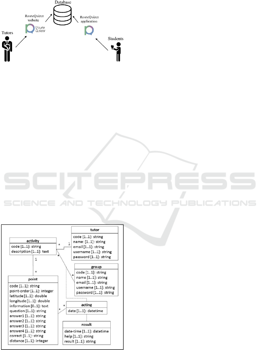
Figure 1: How RouteQuizer works.
which the first and last concern the tutor. The first one
is the creation or management of an educational
activity that takes place in the system’s website. The
second is the use of the application by the students on
the field, and the third is overseeing their
performance, which also requires the use of the
website.
The whole system is divided in three main parts;
the website, which is built for tutors, the android
application that is supposed to be used by groups of
students and the online database, in which all the data
are stored.
The structure of the database is depicted at the
UML class diagram in figure 2. The
activity class
represents the activities that may be designed by
tutors; each activity is associated with only one
tutor. The
point class represents the points of
interest that constitute “destinations” of an activity.
The
point-order attribute determines the order that
each point should be visited, while the
information
attribute holds descriptive information for the point in
Figure 2: RouteQuizer database UML diagram.
order to navigate students to it. The
question, the
four
answers and the right answer attributes
represent the challenge that should be followed
through by students, in order to get information for
the next “point” to visit. The distance attribute
defines the maximum distance that the students
should approach the point, in order to be able to
answer the question. Each time an activity is carried
out by a group of students, an object of the
acting
association class is created and linked with the
respective
results (date, time, and
answer/result for each question, along with
information if the help button is used in the
application). The rest of the classes’ attributes are
easy to understand (
name, email, username,
password, longitude, latitude
).
3.1 Creating an Activity
The first thing a teacher needs to do, in order to create
an activity, is to collect the coordinates of the points
to be included. This can be done using either Google
Earth or a portable GPS device on site.
To create a new activity, the tutor also needs to
provide all the data that will later be used by the
application, using the application’s website. First, the
creator of the activity (the tutor), has to register and
then log in the website’s activity managing system.
After logging in, every tutor can view, add or
edit/delete activities and their associated points. All
data are provided by the tutor with the use of forms.
The fields that have to be filled are the following:
“Code”; the tutor defines the ''Activity Name''. This
should remain the same in all points related to the
particular activity. “Point Order”; the tutor enters the
order in which that point will appear. In each new
activity that a tutor creates, the first point has to have
the point order value of 1, the second a value of 2 and
so on. In this way the teacher is able to largely control
the route that the students will follow, during the use
of the activity. “Latitude”; in this field, he enters the
first part of the coordinates. “Longitude”; in this field,
he enters the second part of the coordinates.
“Information”; information about the point to be
visited and hints as to where the point is located.
“Question”; the question to be displayed to the
students, as soon as they arrive at the point. “Answer
1”; the first possible answer. “Answer 2”; the second
possible answer. “Answer 3”; the third possible
answer. “Answer 4”; the fourth possible answer.
“Right Answer”; the tutor provides the right answer.
It is suggested that this area is filled using “copy –
paste” of the right “Answer” field, to prevent possible
errors while typing. “Distance”; this field is filled by
CSEDU 2017 - 9th International Conference on Computer Supported Education
370
a number to 999, corresponding to the maximum
distance in meters, in which the user must approach,
for the question to be displayed.
After all the information concerning a point is
inserted, the tutor repeats the process for each point
he wants to insert. In this stage, the new activity is
ready to be used by the students. In order to register a
different activity, he defines a different activity name.
3.2 RouteQuizer Android Application
Before launching the application, the user (student
group) has to make sure that mobile data usage and
GPS function are enabled.
The first screen that appears, is an introductory
image that lasts for 3 seconds, and afterwards the user
is asked to register or login in case he has already
been registered. Right after logging in, the application
welcomes the user, and asks an activity’s name. By
typing the activity name that the tutor has provided,
and selecting “OK”, the application loads all data
concerning the first destination point, by requesting
the online database.
3.2.1 Main Screen
The main screen of the game, is a map that can be
zoomed in and out, rotated and centred. The map,
displays a blue dot that indicates the current position
of the user.
In order to make RouteQuizer more appealing and
fun to the students, the position of each destination is
not acknowledged. They can get hints, as to where it
is located, through the information provided by the
tutor. The main tool the users have, is a distance
meter. To prevent the users from getting lost, there is
also a help button.
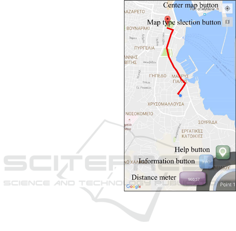
More specifically, the main screen of the
application consists of four buttons and a distance
meter (Figure 3.); the “Center screen button” centers
the screen in the user’s position. By selecting the
“Map type selection button” the user can choose
between four different map types, a road map, a
satellite map, terrain map and a hybrid map. The
“Help button” indicates the destination’s position, by
adding a red marker and the shortest route on the map
(Figure 3.). That way, it prevents the user from
getting lost, but at the same time, the tutor is
informed, whether the help button has been used or
not. The “Information button”, creates a window that
contains all the information provided by the tutor,
helping the user to find the destination point and to
get informed about it. In case the text is long, the
window contains a scroll bar. The “Distance meter”
Figure 3: RouteQuizer application main screen.
represents the distance between the user and the
destination. That way, the user knows whether he is
heading to the right direction or not.
Using the above user interface, and taking
advantage of the distance meter and the available
information, the students have to reach one point at
the time, within a certain distance. That, and also the
fact that (unlike all other geocaching applications)
only one point is loaded at a time, are a powerful tool
in the hands of tutors, because it makes it easy for
them to plan a trip exactly as they want to, and to be
sure that the students did really visit the points.
Upon arrival at their destination, the smartphone
automatically vibrates to notify them that they got
there, and a window containing a question and four
possible answers appears. Along with the multiple
choice question, a new button is also added to the
screen (while the help, information buttons and
distance meter disappear) (Figure 4.). The students
select their answer and press the “Check button” to
RouteQuizer - A Geocaching System for Educational Purposes
371
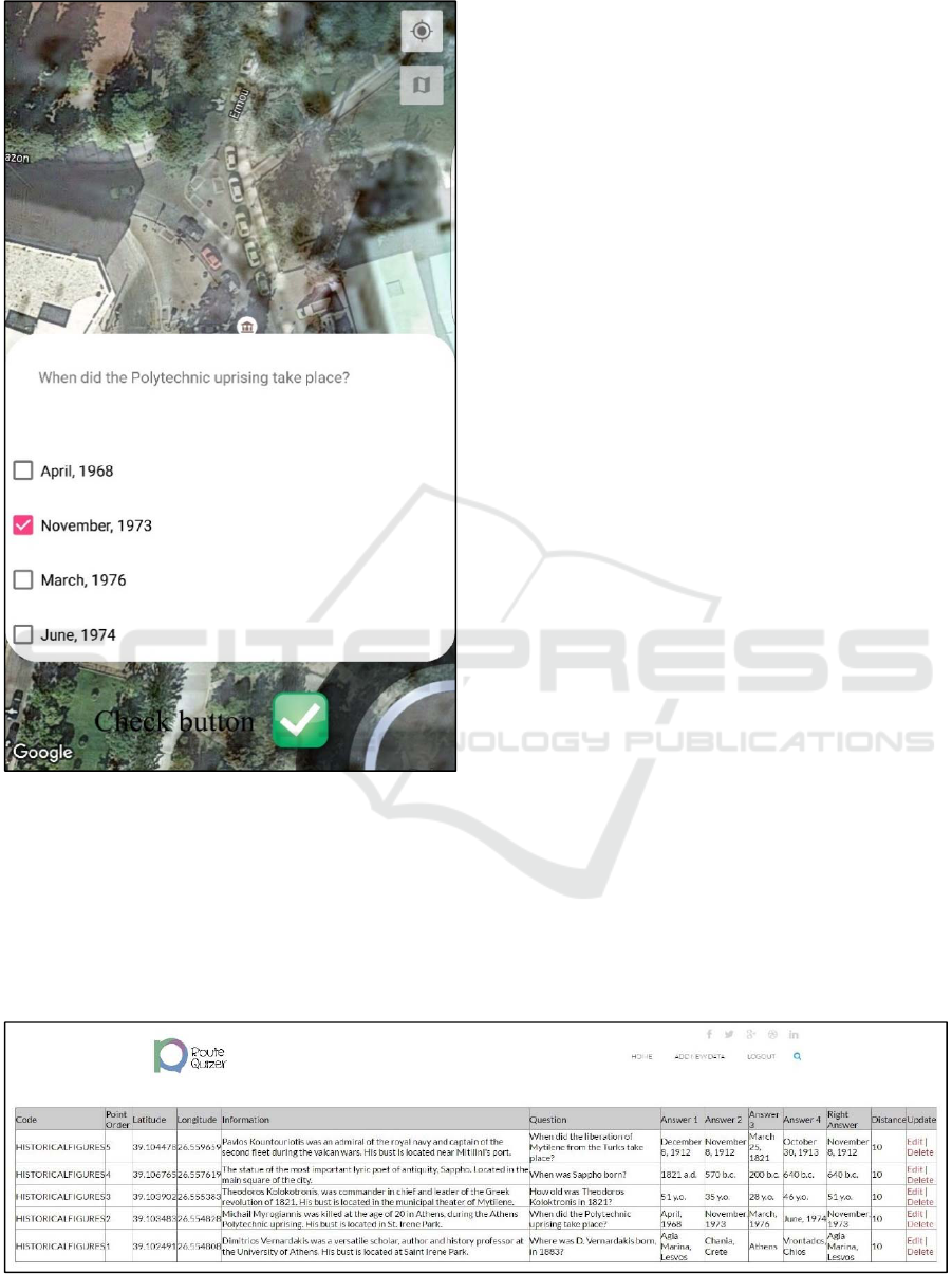
Figure 4: Multiple choice question.
submit their answer. At that point a message informs
them if they were right or wrong, in case they were
wrong it informs them about the right answer, and
also at the same time, their result, the time and date
they answered, as well as whether they used help or
not, are submitted in the according table of the online
database, enabling the tutor to overview students’
performance.
All these procedures, last a few seconds, and
afterwards, the second point data loads. The students
keep visiting their destinations and answering
questions, until they answer the final point’s question.
The application perceives that there are no more
points to load, and a game over screen appears,
congratulating the students, for discovering all points.
A very significant characteristic of the application
is the lack of menus as each screen contains only the
most important elements, without confusing the user.
That simplicity, translates into a fluent and easy user
experience, enabling people that have no previous
smartphone experience, to use the application.
3.3 Viewing the Results of an Activity
As mentioned before, the tutor can overview their
students’ performance. In particular, after logging in
the application’s website, and selecting the “view
results of an activity” button, they are asked to submit
an activity’s name. As a result, a table containing the
following columns appears: “User”; contains the
student’s username. “Activity name”; “Point”; 1 in
case it was the first visited point, 2 if it was the second
etc. “Result”; contains either “Correct” or “Wrong”.
“Help”; contains either “Used Help” or “Did not use
help”, that indicate whether the user used the help
button or not. “Date and Time”; the date and time
when the user answered the particular question.
4 CASE STUDY:
“HISTORICALFIGURES”
ACTIVITY
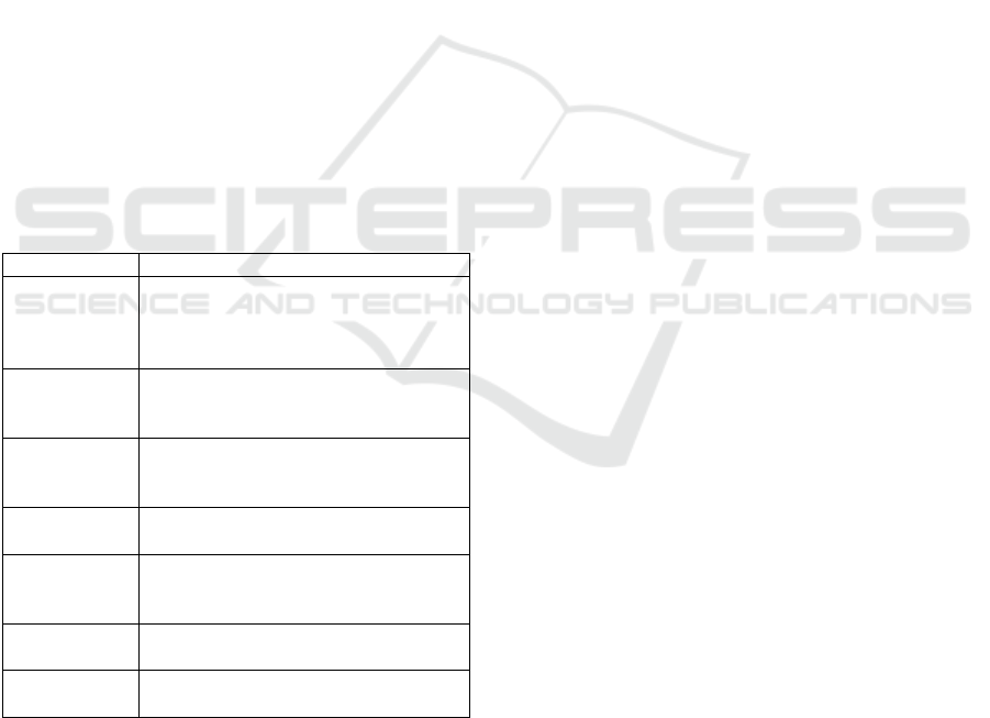
“HISTORICALFIGURES” activity was created by a
University of the Aegean professor, who had no
previous familiarity with the RouteQuizer website.
Fifteen of his undergraduate students, volunteered to
Figure 5: “HISTORICALFEAGURES” activity data, RouteQuizer website.
CSEDU 2017 - 9th International Conference on Computer Supported Education
372
participate in the activity. They were separated in
three groups of five, and asked to complete the
activity.
It includes five points, all of which are busts or
statues of famous historical figures of Lesvos Island
and Greece. The aim was to further acknowledge the
history of their country and Mytilene city.
The activity was created using the RouteQuizer
website (Figure 5), its name was handed over to the
students, and they were asked to start the activity at a
certain time, from different point in the city.
4.1 Result Evaluation
As a result of the “HISTORICALFIGURES” activity,
the three groups managed to visit all the points they
were asked to.
It took team 1, 43 minutes to complete the
activity, team 2, 36 minutes and team 3, 42 minutes.
Team 3 answered four out of five questions correctly,
while teams 1 and 2 answered three questions
correctly each. The first team used help once, the
second twice and the third three times.
After completing the activity, all participants were
asked to fill an evaluation sheet, the conclusions of
which are shown in table 1.
Table 1: Evaluation sheet results.
Subject Evaluation
Smartphone
familiarity
All except one of the participants
were experienced smartphone users,
although 5 of them did not use an
android smartphone.
Previous
geocaching
experience
2 of the students had previously
participated in a geocaching game.
RouteQuizer
operation
No students faced any problems
registering, logging in and loading the
activity.
RouteQuizer
user interface
13 of the students found the
application’s user interface appealing.
Point
searching
difficulties
Half of the students found it easy to
locate the points, while the other half
found it challenging.
Knowledge
acquisition
All students claimed that they learned
something new while playing.
Overall
experience
12 of the students would use the
application again.
All three groups of students, reported that they
followed, almost the same route, in order to visit all
destinations. The way the application works,
presenting one point at a time, and providing the
distance parameter choice, enables tutors to largely
predetermine the route their students are going to
follow.
5 CONCLUSIONS
Although the developing process of RouteQuizer has
been very challenging, due to the many objectives we
had to achieve and the constant modification of the
android platform, it accomplished everything we
aimed for.
The system complies with the standards set by
UNESCO and EU, and offers all mobile learning as
well as all geocaching benefits described by (Taylor,
J.K., et al., 2010).
It is easy to use, and does not confuse the users
with complex menus and irrelevant settings. That
way, even students with no smartphone experience,
can easily complete an activity, not worrying about
how to operate the application.
It offers tutors, many customization capabilities,
mainly through the use of the required distance, but
also by the absence of geographical constraints.
Provides information on student’s performance,
not only on whether they answered correctly, but also
if they used help to reach their destination and the
exact date and time they responded to each question.
It is an attractive user experience. The way in
which the application presents the destinations,
providing information and the distance to be
travelled, adds a degree of difficulty that makes the
destination search fun for the students. Also, the
existence of “help” choice, ensures that the search
will be safe, preventing the students from getting lost.
The application is supported by all android
operating system versions that are in use today but
also in the future (Android 2.1 and Android 6.0.1).
According to Google’s data, versions 2.1 till 6.0.1
cover all currently used android smartphones.
It is perfectly executable regardless of the mobile
phone model. Due to the variety of many different
smartphones in the market, (different manufacturers,
screen sizes, resolutions and performance), the
actions to be taken in order to create a compatible
application are many, and relate primarily to meet
different screen resolutions, which the RouteQuizer
application has fully addressed and tested
successfully, by creating all images in five different
sizes.
Exploits every positive aspect a smartphone can
possibly offer during the educational process, such as
portability, which is basically the most important
contribution of the mobile phone in general, but also
particularly in the specific application, connectivity,
as it communicates with the database without
requiring any action from the user, it is pleasant to
use, due to the simplicity of the user interface, and all
the information is transferred directly to the device
RouteQuizer - A Geocaching System for Educational Purposes
373

without requiring excellent mobile network.
No negative effect on the pupil. Because of the
fact that the application is used exclusively on the
field, and not in the classroom, it does not distract
students in any way from the educational process. At
the same time, proper organization of students in
groups, can avoid potential adverse effects of the
mobile phone, such as inequality between students,
bullying, as the use of the mobile phones is limited on
the field, loss of concentration and loss of collegiality,
since the students are encouraged to work together to
achieve the objective, which is to reach their
destination, and correctly answer the question.
5.1 Future Work
As in all applications, there are many capabilities of
improvement, especially for an application like this,
which introduces something innovative, and a new
way of utilizing new technology. Below several ways
to improve the application are proposed.
The creation of a forum, where tutors would
exchange experiences and ideas for creating better
activities for their students;
Translation of the system in many different
languages;
Embedding Google Maps on the website, so that
the tutors can add markers to the points they want,
instead of collecting the coordinates using Google
Earth;
Enabling tutors to provide photographs and
videos along with the information.
Development of an iOS (Apple’s operating
system, used in iPhones) version of the
application.
Furthermore, we plan to hold several activities in
which students and teacher of various educational
levels will participate, in order to acquire more
feedback and make RouteQuizer even better.
REFERENCES
Christie, A., 2007. Using GPS and Geocaching Engages,
Empowers and Enlightens Middle School Teachers and
Students. Meridian, Winter Submission.
Ellbrunner, H., Barnikel, F., Vetter, M., 2014.
“Geocaching” as a Method to Improve not only Spatial
but also Social Skills, Available at http://gispoint.de/
fileadmin/user_upload/paper_gis_open/537545010.pdf.
European Commission, 2015. Mobile Learning and Social
Media in Adult Learning. Europe 2020: Employment
policies, Vocational training and adult education.
European Union, 2015. Education and Training 2020.
Official Journal of the European Union, C417/25.
Hamm, B., Geocaching in Education: A Literature Review,
Green State University, Available at
http://cte6010.bgsu.wikispaces.net/file/view/HammLit
eratureReviewFINAL.doc.
Ihamäki, P.J., 2012. Geocaching: Interactive
Communication Channels Around the Game,
Eludamos. Journal for Computer Game Culture.
Jacob, S.M., Issac, B., 2008. The Mobile Devices and its
Mobile Learning Usage Analysis, Proceedings of the
International MultiConference of Engineers and
Computer Scientists 2008 Vol I IMECS 2008, 19-21,
Hong Kong.
Jones, T., 2012. Combining Geocaching and Children’s
Literature, Macrothink institute, Journal of Studies in
Education.
Kay, R.H., Lauricella, S., 2014. Investigating the Benefits
and Challenges of Using Laptop Computers In Higher
Education Classrooms, Canadian Journal of Learning
and Technology, 40(2).
Kohen-Vacs, D., Ronen, M., Cohen, S., 2012. Mobile
Treasure Hunt Games for Outdoor Learning, Bulletin
of the IEEE Technical Committee on Learning
Technology, Volume 14, Number 4.
Lisenbee, P., Hallman, C., Landry, D., 2015. Geocaching is
Catching Students' Attention in the Classroom. The
Geography Teacher, 12:1, 7-16, DOI:
10.1080/19338341.2014.975147.
Palmárová, V., Lovászová, G., 2012. Mobile Technology
used in an adventurous outdoor learning activity: a
case study. Problems of education in the 21st century
Volume 44, ISSN 1822-7864.
Robison, D., 2011. Geocache adventures: Ubiquitous
handheld computing as an aid to promote
environmental awareness amongst students.
International Journal of Innovation and Leadership in
the Teaching of Humanities 1(2): 47-56.
Taylor, J.K., Kremer, D., Pebworth, K., Werner P., 2010.
Geocaching for Schools and Communities, Human
Kinetics, ISBN-13: 9780736083317.
UNESCO, 2012. Turning on Mobile Learning in Europe.
Illustrative Initiatives and Policy Implications.
http://unesdoc.unesco.org/images/0021/002161/21616
5E.pdf.
UNESCO, 2013. Policy Guidelines for mobile learning.
http://unesdoc.unesco.org/images/0021/002196/21964
1e.pdf.
Vitale, J.L., McCabe, M., Tedesco, S., Wideman-Johnston,
T., 2012.
Cache Me If You Can: Reflections on
Geocaching from Junior/Intermediate Teacher
Candidates, International Journal of Technology and
Inclusive Education (IJTIE), 1(1).
CSEDU 2017 - 9th International Conference on Computer Supported Education
374
