Extending Land Administration Domain Models with a Goal Perspective
Christophe Ponsard
1
and Mounir Touzani
2
1
CETIC Research Centre, Charleroi, Belgium
2
Acad
´
emie de Toulouse, Toulouse, France
Keywords:
Cadastral System, Land Registration, Spatio-temporal Modelling, Goal-oriented Requirements Engineering.
Abstract:
Land administration covers many complex processes for managing rights over land, estimating value, gather-
ing revenues and regulating land use. Its organisation typically relies on land registration and cadastre. Over
the years, elaborated domain models have emerged and have been standardised. While those models address
many dimensions of this domain, they fail to capture the rationale behind the design of the model or leave
it quite implicit. In this paper, we propose to augment such domain models with a goal dimension in order
to provide better guidance in the design of new systems and better understanding of existing systems, espe-
cially in the perspective of driving the wide variety of E.U. systems to evolve towards more interoperability.
Our work relies on the KAOS goal-oriented framework for system design and highlights the use of sound
structuring and reasoning techniques.
1 INTRODUCTION
The term land administration (LA) was defined by the
United Nations Economic Commission for Europe as:
“the process of determining, recording and dissemi-
nating information about ownership, value and use of
land and its associated resources. These processes in-
clude the determination (sometimes called ‘adjudica-
tion’) of land rights and other attributes, their survey
and description in a detailed documentation, and the
provision of relevant information for supporting land
markets” (UNECE, 1996).
The key LA concepts were identified by
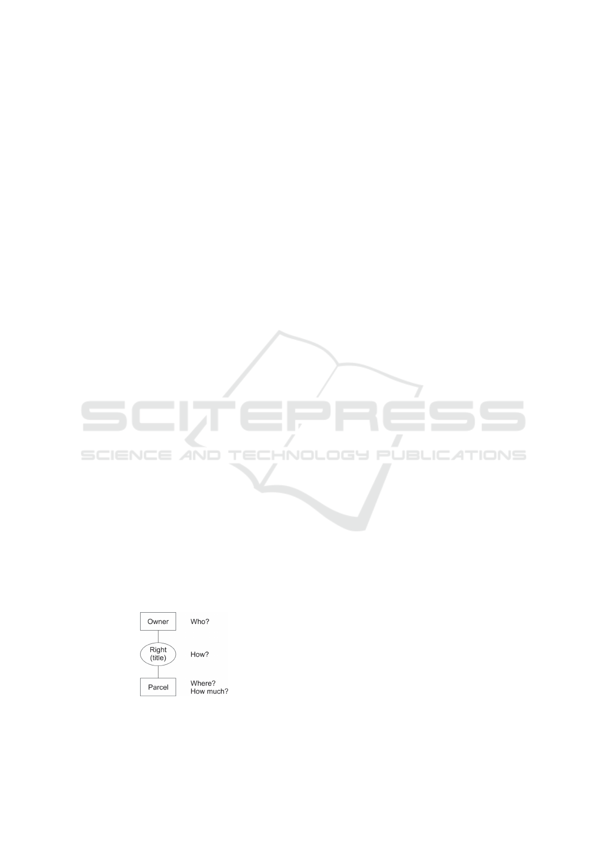
(Henssen, 1995) and are shown in Figure 1.
The owner (“Who”) and parcel (“Where”/“How
much”) concepts are connected by a Right relation-
ship which is often generalised into “triple-R” for
Right/Restriction/Responsibilities (for the “How”).
Figure 1: Key domain concepts (Zevenbergen, 2004).
Those concepts form the core of reference do-
main models such as Core Cadastral Domain Model
(CCDM), the Land Administration Domain Model
(LADM, ISO 19152) and the Social Tenure Domain
Model (STDM). Those models are discussed and
compared in section 2. The processes managing those
concepts are usually split across the following two
systems which can be managed by a single or differ-
ent organisations (Henssen, 1995):
Land registration deals with the official recording
of rights on land concerning changes in the legal sit-
uation of defined parcel. It can be organised either
through deed or title registration, with a progressive
transition to the second option observed in many E.U.
countries (Yavuz, 2005). This covers the “Who” and
“How” questions.
Cadastre maintains a comprehensive public in-
ventory of data concerning properties of a country or
district. It is based on a survey of their boundaries and
value. It gives an answer to the questions “Where”
(spatial dimension) and “How much” (both for own-
ership transfer and taxation purposes).
The mentioned domain models essentially provide
a reference vocabulary (or ontology) for describing
the complex data (rights, geometry of parcels,...) in-
volved LA. Such models support the development and
interoperability between LA systems in an efficient
way. However, they are less good at driving the de-
sign of new systems or at understanding the rationale
behind the design of existing systems. The reason is
that the “Why” dimension of the different model fea-
244
Ponsard, C. and Touzani, M.
Extending Land Administration Domain Models with a Goal Perspective.
DOI: 10.5220/0006350202440249
In Proceedings of the 3rd International Conference on Geographical Information Systems Theory, Applications and Management (GISTAM 2017), pages 244-249
ISBN: 978-989-758-252-3
Copyright © 2017 by SCITEPRESS – Science and Technology Publications, Lda. All rights reserved
tures are currently not explicitly captured but it would
be worth being supported because:
• E.U. member countries have all deployed their
own LA systems. Although they follow similar
principles they are not harmonized at all which
is the long term goal to achieve for the E.U. An
overview of all European systems has already
been carried out as well as some targeted com-
parative work (Yavuz, 2005)(EU PCC, 2009).
• main LA actors (FIG/World bank) are increas-
ingly stressing that LA systems should be “fit-for-
purpose” rather than blindly complying with com-
plex technological solutions and rigid regulations,
i.e. LA should be designed to meet people’s needs
and relationship to land in a sustainable way (En-
emark et al., 2014). This is especially for devel-
oping countries (Williamson, 2000).
This paper aims at proposing an extension to ex-
isting domain models that explicitly address the miss-
ing goal dimension. In order to achieve this, we apply
methods and notations from the goal-oriented require-
ments engineering field (van Lamsweerde, 2001).
This work also applies specific spatio-temporal an-
notations for guiding in structuring and reasoning on
goal models (Touzani and Ponsard, 2016).
This paper is organised as follows. Section 2
presents and compares three main domain models for
LA. Section 3 details the goal-oriented framework ap-
plied to extend the existing models with explicit goal
and responsibility modelling. The extension itself is
detailed in section 4 while section 5 discusses some
related work. Finally section 6 draws conclusions and
gives some perspectives to further extend this work.
2 REVIEW OF DOMAIN MODELS
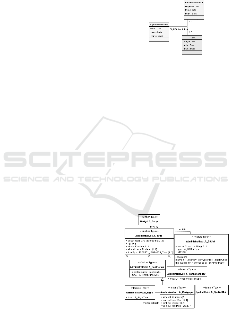
2.1 Core Cadastral Domain Model
The Core Cadastral Domain Model (CCDM) was pro-
posed at the FIG 2002 Congress. It broadly covers
land registration and cadastre. It provides an extensi-
ble ontology supporting the sound design of a cadas-
tral system using a model-driven architecture that re-
lies on that shared model. CCDM Version 1.0 was
presented in 2006 and also included 3D aspects (Oos-
terom et al., 2005). The core model is depicted in Fig-
ure 2 which is very close to the abstract model of Fig-
ure 1. CCDM concepts also carry explicit identifiers
and date attributes enabling traceability and temporal
reasoning.
Figure 2: Overview of CCDM.
2.2 Land Administration Domain
Model
The Land Administration Domain Model (LADM) is
a conceptual model, and not a data product specifica-
tion. It is meant to be a descriptive standard and not
a prescriptive one. Domain specific standardisation
is needed to capture the semantics of the LA domain
on top of the agreed foundation of basic standards for
geometry, temporal aspects, metadata and also obser-
vations and measurements from the field. The LADM
goals are to establish a shared ontology, support de-
velopment of related software, facilitate the exchange
of data and provide support for quality management
in LA (Lemmen et al., 2015). It has been standard-
ised under ISO 19152 (ISO, 2012).
LADM is quite elaborated and has very detailed
specialisation hierarchies for all the LA concepts.
Figure 3 is a refinement of Figure 1. Owner and Par-
cel are the LA Party and Spatial Unit respectively lo-
cated in the top left and bottom right cornet while the
rest of the concepts presented details different kinds
of Rights/Restrictions/Responsibilities (RRR).
Figure 3: Overview of LADM.
Extending Land Administration Domain Models with a Goal Perspective
245
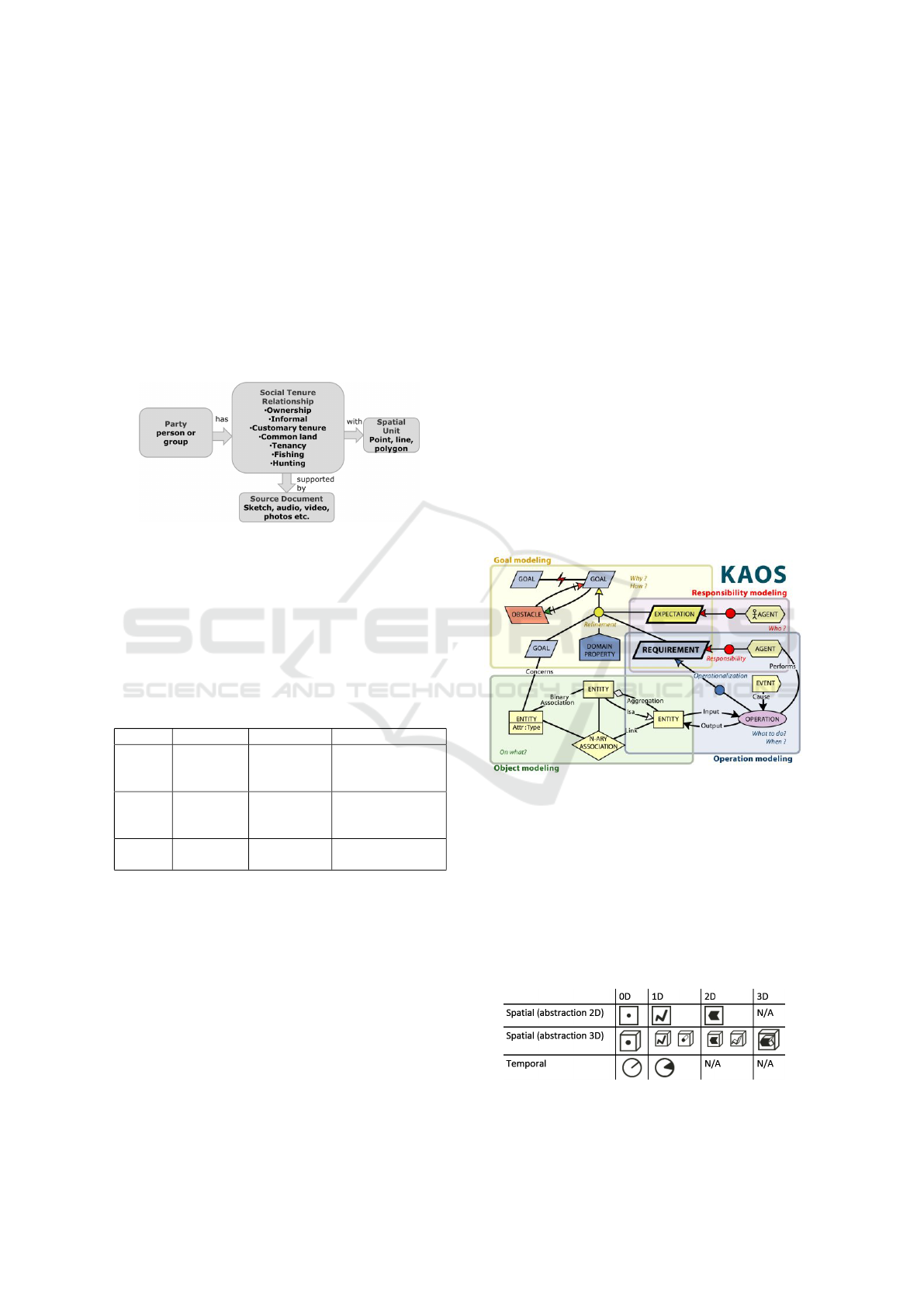
2.3 Social Tenure Domain Model
The Social Tenure Domain Model (STDM) is a vari-
ant of the LADM that presents a generic and inclusive
solution. It was released in 2014 together with Open
Source tools with the aim to help in building flexi-
ble land administration systems. For this purpose, it
proposes a modelling of relations that is independent
from their level of formalization and/or legality. For
example, it supports all forms of land rights including
customary and informal rights as shown in Figure 4
borrowed from (Christl et al., 2015).
Figure 4: Overview of STDM.
2.4 Comparison
The above models are compared in Table 1. LADM
and STDM column show extra (+) features w.r.t. the
previous column. In short, LADM is the standard and
covers CCDM while STDM is a less formal variant.
For sake of simplicity, this paper will use CCDM.
Table 1: Comparison of main LA domain models.
Concept CCDM LADM STDM
Owner Natural
person
+group
+cooperative
+company
+municipality
+couple
Property Parcel,
building,
ways
+land
surveys
+text descr.
+unstruct. lines
+3D volume
Rights Formal
ownership
+Restriction
+Responsib.
+special rights
(e.g. hunting)
3 METHOD: GOAL-ORIENTED
SPATIO-TEMPORAL ANALYSIS
Goals capture, at different levels of abstraction, the
objectives the system under consideration should
achieve. Goal-Oriented Requirements Engineering
(GORE) is concerned with the use of goals for elic-
iting, elaborating, structuring, specifying, analysing,
negotiating, documenting, and modifying require-
ments. To support our research, we focus on KAOS,
a specific GORE method (van Lamsweerde, 2009).
However, the same concepts and methods can be ap-
plied in other GORE variants like i* (Yu and My-
lopoulos, 1997) and GRL (ITU, 2012).
The KAOS method is organised in four sub-
models graphically depicted in Figure 5:
• The goal model structures functional and non-
functional goals. It also helps to identify related
conflicts and reason about their resolution. It is
graphically represented as a goal tree which can
also capture system design variants.
• The object model defines and interrelates all con-
cepts involved in goal specifications. Its represen-
tation is aligned with the UML class diagram.
• The agent model identifies the agents of both the
system and the environment as well as their inter-
faces and responsibilities. They can be shown as
part of goal trees or in more specific diagrams.
• The operations model describes how agents
functionally cooperate to ensure the fulfilment of
their assigned requirements and hence the system
goals. Functional flow diagrams are used here.
Figure 5: KAOS Meta-model.
Reasoning on both space and time is important
as Geographic Information Systems (like LA) and
Cyber-Physical Systems are increasingly developing.
For this purpose, specific notations depicted in Fig-
ure 6 have been integrated into the goal and object
models together with a set of patterns and heuristics
guiding in the discovery and structuring of goals, e.g.
spatial and temporal refinement patterns, quantitative
reasoning, transposition across domains, etc.
Figure 6: Space-time pictograms.
GISTAM 2017 - 3rd International Conference on Geographical Information Systems Theory, Applications and Management
246
4 GOAL-AWARE MODEL FOR
LAND ADMINISTRATION
This section provides excerpts of the goal-
oriented model with the aim to illustrate its
global structure and systematic building tech-
niques. The full model is available online at
doi:10.13140/RG.2.2.21197.84969. It was build
using the Objectiver toolset (Respect-IT, 2005).
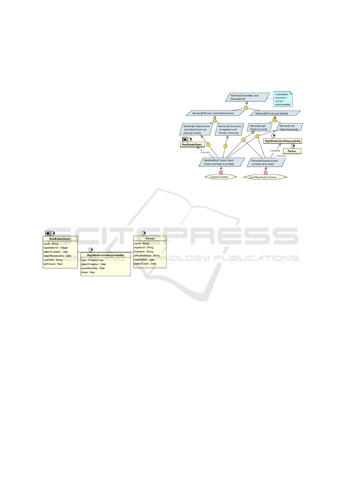
4.1 Capturing the Relevant Vocabulary
In a goal-oriented context, the object model aims at
gathering and structuring the vocabulary required for
expressing goals. It can be built iteratively together
with the goal model. We could validate that the
CCDM model fits this purpose. In our modelling,
depicted in Figure 7, identifiers and time intervals
during which an entity exists have also been explic-
itly modelled with more meaningful names (e.g. da-
teOfDeath for a person, dateOfExpiration for RRR).
Concept specialisations were detailed here but are
similar to those available in existing domain models.
We also used spatio-temporal decorators to tag the di-
mensions that are present in each concept.
Figure 7: Object Model.
4.2 Capturing Strategic Goals
The top goals of our system modelling are of strategic
nature and are depicted in Figure 8. Those goals are
also aligned with strategic goals and responsibility as-
signments published in key literature references such
as (Enemark, 2001) and (Zevenbergen, 2004). The
diagram should be read vertically with more abstract
goals at the top and more operational goals at the bot-
tom and following yellow refinement nodes connect-
ing goals with their sub-goals. So going up/down re-
spectively means asking “Why?”/“How?”.
The goal introduced at the top is about sustainabil-
ity which has three dimensions: financial, social and
environmental which can be identified in later sub-
goals. However, the first refinement is based on the
classical functional versus non-functional distinction.
The former is called “effectiveness” and covers main
functions related to the planning and enforcement of
land use. The later is called “efficiency” and is ex-
pressed in terms of legal protection and value man-
agement, covering both citizen aspects (e.g. for prop-
erty transfer) and the public authorities (e.g. for col-
lecting taxes).
Figure 8: Strategic Goals.
Further refinements are not fully detailed. How-
ever a major observation is that they all rely on two
key subsystems: land registration and cadastre. The
rationale between this decomposition is based on in-
formation control. Looking at the object-model:
• land registration is controlling the Right/Restric-
tion/Responsibility relationship, and consequently
many related contractual and legal aspects.
• cadastre is controlling the RealEstateObject, es-
pecially its classification, associated topographic
characteristics and the associated value.
• an external system, the Population Register, man-
ages the Person information.
4.3 Robust Design Rationales
High-level goals assigned to sub-systems can be fur-
ther refined to make explicit all the relevant require-
ments. Different techniques can be used to provide
some assurance of completeness and robustness:
• refinement patterns drive goal decomposition to-
wards completeness with rationales. Some com-
mon patterns are temporal milestones and case-
based decomposition.
• obstacle analysis enables the identification of un-
desired behaviours and mitigate them by making
existing goals more realistic or by the introduction
of goals correcting or anticipating obstacles.
Figure 9 shows the refinement of the main cadas-
tral goal Maintain[Real Estate Object Known and
Kept Up-to-date]. The left part of the refinement is
a milestone pattern composed of three key steps con-
trolled by different agents. However this design does
Extending Land Administration Domain Models with a Goal Perspective
247
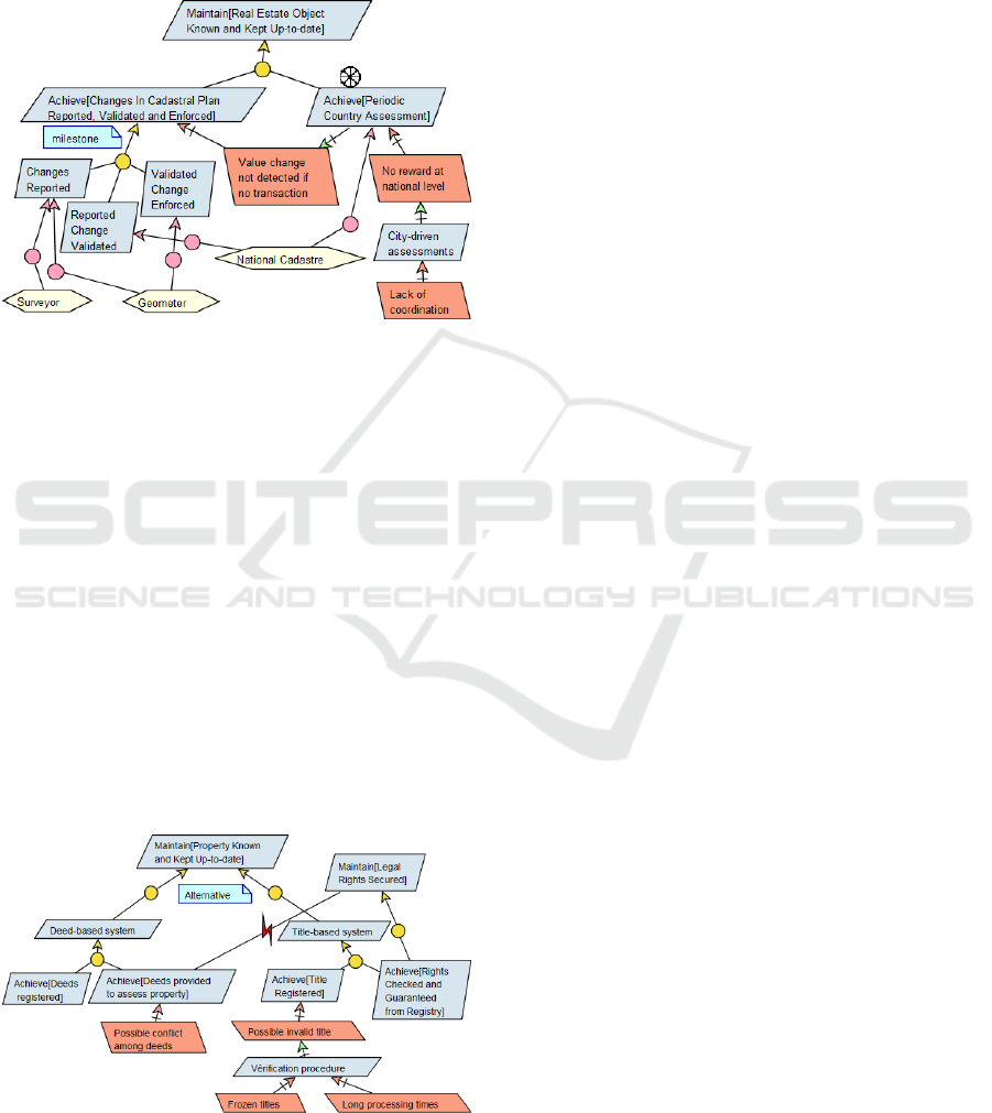
not allow to detect changes that occur outside of a
transaction, e.g. when some work increases the cadas-
tral rent. To address this, the right goal introducing a
periodic systematic assessment is introduced. How-
ever, this goal might suffer from other obstacles, as
detailed in the next section.
Figure 9: Modelling cadastre updates.
4.4 Capturing Design Variability
Although systems are developed to fulfil common
strategic goals, the fact they where historically de-
signed in different countries implies that there is a
large variability in the way those goals are imple-
mented in national systems. We review here the main
variability points (Bogaerts and Zevenbergen, 2001):
Deed Registration Versus Title Registration. Deed
registration is based on the transaction document
(with rules like: an older document prevails) and thus
provide no guarantee of the title. Title registration
means the right is really associated to the parcel and
can be guaranteed. Both systems are modelled in Fig-
ure 10. Two distinct refinements are used at the top
of the diagram. Each alternative is further refined and
analysed.
Figure 10: Modelling the titles vs deeds alternatives.
In the deed-based systems the main obstacle (in
red) is that deeds can be questioned and introduce
a conflict with the strategic goal of legal protection.
In a title-based system, the registration process must
be careful and might induce long processing times or
even frozen titles. The tendency is to move to title
guarantee but could still rely on an underlying “deeds
system”, thus combining both alternatives. So the dis-
tinction is evolving towards positive versus negative
systems, given they provide or not a guarantee.
Land Registration and Cadastre Components Sep-
arated or Integrated: within the same organisa-
tion. Given their close interrelation, those compo-
nents should ideally be integrated. However for his-
torical reasons, they might have been developed inde-
pendently with some data replication. Different tech-
nical designs can cope with this, like synchronisation
procedures or a linking database. Long term evolution
towards a integrated system is also possible. Those
aspects are less relevant to capture in a goal model.
Centralized Versus Decentralized Deployment.
Decentralisation can be decided for organisational or
political reasons (e.g. in a federal country) but will
keep a national authority ensuring consistency, e.g.
the global cadastre can be kept at the federal level
while tax can be perceived at regional or city level.
However, this can induce possible cooperation prob-
lems in the organisation, e.g. in Belgium, the cadas-
tral rent is not being systematically updated because
the federal level has no revenue out of it and this im-
pacts the funding of cities.
Fiscal (Tax-based) Versus Legal Background. The
former is easier to fund and update (only for market
value and on a yearly basis) while the later is more
complex and expensive because it needs to be accu-
rate and kept up-to-date on a daily basis.
General Boundaries Versus Fixed Boundaries. The
former relies on visible features of the ground while
the later uses exact and marked coordinates. This is
already captured by the parcel ontology.
5 DISCUSSION AND RELATED
WORK
A systems approach to land registration and cadastre
was developed by (Zevenbergen, 2004). This work
focuses on the technical, legal and organisational as-
pects, and their interrelation of such systems of land
registration. The work stresses the need to have a fully
integrated system view covering both land registra-
tion and cadastre. It covers not only the static dimen-
sions (as described in section 2) but also dynamic di-
mensions, with a focus on the important adjudication,
transfer and subdivision processes. However, it only
relies on informal process modelling and is also miss-
GISTAM 2017 - 3rd International Conference on Geographical Information Systems Theory, Applications and Management
248

ing the capture of all the rationales driving the system
design.
A UML model for cadastral system was proposed
by (Tuladhar, 2003). It shows how different UML dia-
grams can capture both structural and behavioural di-
mensions of the system. However UML models have
a total lack of goal perspective: the closest diagram
is the use case diagram which can only capture func-
tional requirements and performing actors.
A KAOS model was build for modelling the Bel-
gian cadastre in 2002 (Dechesne et al., 2002). The
goal was to support the development of an unified
cadastral database. The object part of the model was
not aligned with the still emerging standards but is
based on the same key notion of right between a per-
son and a real property. Those concepts are also de-
tailed using a rich inheritance hierarchy. The pro-
posed goal model first details the “as-is” system fo-
cusing on the main missions like: maintaining the
cadastral map up-to-date, performing value estima-
tion, managing sales, etc. It reveals some duplicated
data which were addressed by an improved “to-be”
goal model used to drive the system evolution.
6 CONCLUSIONS
In this paper, we have shown how goal models can
provide useful enhancements to LA domain models
in order to provide a better understanding and reason-
ing capabilities on the design of such complex sys-
tems. We illustrated some key mechanisms to struc-
ture goals and variants and also to reason on them.
Our modelling is still being enhanced to reach bet-
ter completeness (e.g. for planning tasks), more de-
sign variants (e.g. adjudication strategies) and also
to introduce the missing operation level that can pro-
vide a stronger link with technical requirements and
give better control on how to evolve the deployed sys-
tems. Our ultimate goal is to be incorporate our re-
sults in future evolutions of LA domain models be-
cause this will definitely help in the process of setting
up or evolving a LA system. We are currently apply-
ing our framework to the co-analysis of LA systems in
the perspective of European convergence with an ini-
tial focus on the neighbouring countries of Belgium.
ACKNOWLEDGEMENTS
We thanks the Belgian ACED (Cadastre and Land
Registration office) for sharing their case with us.
REFERENCES
Bogaerts, T. and Zevenbergen, J. (2001). Cadastral systems
alternatives. Computers, Environment and Urban Sys-
tems, 25(45):325 – 337.
Christl, A. et al. (2015). Standard Open Source Software
for the Social Tenure Domain. Annual World Bank
Conference on Land and Poverty.
Dechesne, B., Delannay, G., and Massonet, P. (2002).
Agora Project: Requirements Analyse for the Cre-
ation of an Unified Cadastral Database.
Enemark, S. (2001). Land administration infrastructures for
sustainable development. Property Management, 19.
Enemark, S. et al. (2014). Fit-For-Purpose Land Adminis-
tration: Joint FIG. FIG.
EU PCC (2009). Cadastral Information System, a resource
for the E.U. policies. Overview of the Cadastral Sys-
tems of the E.U. Member States - Part I-II-III.
Henssen, J. (1995). Basic Principles of the main cadas-
tral Systems in the World. In Proc. Seminar Modern
Cadastres and Cadastral Innov., FIG Commission 7.
ISO (2012). 19152 - Geographic information - Land Ad-
ministration Domain Model. http://www.iso.org.
ITU (2012). Recommendation Z.151 (10/12), User Re-
quirements Notation (URN) Language Def.
Lemmen, C., van Oosterom, P., and Bennett, R. (2015). The
Land Administration Domain Model. Land Use Pol-
icy, 49:535 – 545.
Oosterom, P. V., Stoter, J., and Lemmen, C. (2005). Mod-
elling of 3d cadastral systems.
Respect-IT (2005). The Objectiver Requirements Engineer-
ing Tool. http://www.respect-it.com.
Touzani, M. and Ponsard, C. (2016). Towards modelling
and analysis of spatial and temporal requirements. In
24th IEEE Int. Requirements Eng. Conf.
Tuladhar, A. M. (2003). Why Is Unified Modeling Lan-
guage (UML) for Cadastral Systems? M.Sc. Univer-
sity of Twente.
UNECE (1996). Land Administration Guidelines With Spe-
cial Reference to Countries in Transition. United Na-
tions Economic Commission for Europe.
van Lamsweerde, A. (2001). Goal-oriented requirements
engineering: a guided tour. In 5th IEEE Int. Sympo-
sium on Requirements Engineering.
van Lamsweerde, A. (2009). Requirements Engineering -
From System Goals to UML Models to Software Spec-
ifications. Wiley.
Williamson, I. P. (2000). Best practices for land adminis-
tration systems in developing countries. World Bank
Other Operational Studies 16732, The World Bank.
Yavuz, A. (2005). A comparative analysis of cadastral sys-
tems in the eu countries according to basic selected
criteria. FIG Working Week.
Yu, E. S. K. and Mylopoulos, J. (1997). Enterprise mod-
elling for business redesign: The i* framework. SIG-
GROUP Bull., 18(1):59–63.
Zevenbergen, J. (2004). A Systems Approach to Land Reg-
istration and Cadastre . Nordic Journal of Surveying
and Real Estate Research.
Extending Land Administration Domain Models with a Goal Perspective
249
