
Design and Implementation of Falling Star
A Non-Redudant Spatio-Multidimensional Logical Model for Document Stores
Ibtisam Ferrahi
1
, Sandro Bimonte
2
, Myoung-Ah Kang
3
and Kamel Boukhalfa
4
1
Department of Computer Science, Faculty of Sciences, University Mhamed Bougara of Boumerdes, Boumerdes, Algeria
2
TSCF, Irstea. 9 Av. Blaise Pascal, Aubiere, France
3
LIMOS-UMR CNRS, ISIMA, Blaise Pascal University, Campus des cezeaux, 63178 Aubière, France
4
USTHB, LSI Laboratory, Houari Boumediene University of Sciences and Technology, Algiers, Algeria
Keywords: Multidimensional Model, NoSQL Databases, Data Warehouses.
Abstract: In the context of Spatial Big Data, some NoSQL spatial DBMSs have been developed to deal with the
Spatiality, Velocity, Variety, and Volume of Spatial Big Data. In this context, some works recently study
NoSQL logical Data Warehouse (DW) models. However, these proposals do not investigate storing and
querying spatial data. Therefore, in this paper we, propose a new logical model for document Spatial DWs.
Moreover, motivated by the expressivity, readability and interoperability offered by UML profile, we
represent our model using a UML profile. Finally, we present an implementation in document Spatial DBMSs.
1 INTRODUCTION
In the era of Spatial Big Data (Shekhar et al., 2012),
more and more geo-referenced data are available via
new acquisition data systems (remote sensing, social
networks, sensors, etc.). In this context, some NoSQL
Spatial Database Management Systems (SDBMSs)
have been developed to deal with the Velocity,
Variety, and Volume of data. Several NoSQL
databases have been proposed that can be classified
into four categories: Key-value, Extensible record,
Graph, and Document. Key-value database is a
collection of data without a schema and organized as
a collection of key-value pairs. Data represented by
the "value" is accessed using "key". Extensible record
databases represent data with tables, where each row
can present different attributes (different columns).
Graph database uses graph structure with nodes,
edges and properties associated to theses nodes and
edges to store the data. Graph databases are suited
for applications in which there are more
interconnections between the data like social
networks. Document databases allow storing and
querying complex structured information as geo-
referenced documents (tweets, images, etc.).
GeoBusiness Intelligence (GeoBI) technologies
represent first citizens of systems allowing analysis of
Spatial Big Data. GeoBI systems include Spatial Data
Mining, Spatial OLAP, spatial statistical tools, and
reporting systems. Data Warehouse (DW) and OLAP
systems allow analyzing huge volume of data
represented according to the multidimensional model,
which defines the concept of dimension (the analysis
axes) and fact (the analysis subject) (Kimball et
Ross., 2002).
On one hand, Spatial Data Warehouses (SDWs)
and Spatial OLAP (SOLAP) systems extend OLAP
functionalities by integrating spatial data into the
multidimensional analysis. On the other hand,
warehousing spatial data raises several challenges
due to the design, the storage and the visualization of
spatio-multidimensional data.
In the context of alphanumeric data, (Chevalier et
al., 2015) proposes two approaches, “1 collection
based approach”, and “n collections based
approach”, for warehousing and OLAPing huge
volumes of complex data using document DBMSs.
The “1 collection based approach” proposes to
represent dimensions and facts in a single document
collection to avoid “join” operations among
documents. However, join operations are not natively
supported by schemaless document DBMSs. The “n
collections approach” is similar to the relational star
and snowflake approaches (Kimball et Ross., 2002)
where facts and dimensions are stored using different
collections. This approach avoids data redundancy,
but leads to implement join operators. Therefore,
(Chevalier et al., 2015) highlights that for most of
Ferrahi, I., Bimonte, S., Kang, M-A. and Boukhalfa, K.
Design and Implementation of Falling Star - A Non-Redudant Spatio-Multidimensional Logical Model for Document Stores.
DOI: 10.5220/0006353803430350
In Proceedings of the 19th International Conference on Enterprise Information Systems (ICEIS 2017) - Volume 1, pages 343-350
ISBN: 978-989-758-247-9
Copyright © 2017 by SCITEPRESS – Science and Technology Publications, Lda. All rights reserved
343

OLAP queries the “1 collection approach” seems to
have a better query performance than the “n
collections approach”.
Despite of several existing geospatial applications
using document SDBMSs (Zhang et al., 2014; Lutz et
al., 2014;), to our knowledge no work studies the
design of spatio-multidimensional models using
document DMBSs.
Therefore, in this paper, based on the “1
collection” approach, we propose a new logical
model, called Falling Star, for SDW.
Falling Star represents an efficient solution for
storing and querying multidimensional complex geo-
referenced documents. Falling Star proposes a
particular logical representation of warehoused data
to handle with issues related to the redundancy of the
spatial data, which affects storage and computation
performances (as already shown for Relational
Spatial DBMSs (Siqueira et al., 2008). Moreover,
motivated by expressivity, readability and
interoperability offered by UML, we propose an
UML profile for the design of: (i) document databases
and (ii) SOLAP applications using Falling Star based
on the document databases model.
Indeed, the benefits of the usage of UML, and its
associated Computer-Aided Software Engineering
tools, for designing, developing and maintaining
complex information systems have been widely
proved in several computer science and application
domains. Finally, we evaluate our proposal with some
experiments.
The paper is organized in the following way:
Section 2 presents related work, and section 3 details
the case study used all along the paper. Section 4
presents our spatio-multidimensional logical model
and its UML profile representation. Section 5 shows
the implementation. Performance study is discussed
in Section 6, which followed by conclusion and future
work.
2 RELATED WORK
In this section, we present some works that study the
implementation (Sec 2.1) and the design (Sec 2.2) of
spatial and/or OLAP applications using document
DBMSs.
2.1 Implementation
Nowadays, among the most popular document
SDBMSs, we can find CouchBase and MongoDB
(Filho et al., 2015). MongoDB is a cross platform
document database. Classified as a NoSQL database,
MongoDB eschews the traditional table-based
relational database structure in favour of JSON-like
documents with dynamic schemas (MongoDB calls
the format BSON). MongoDB supports a very rich set
of spatial data types. Using GeoJSON format,
MongoDB can store spatial data with a variety of
geographic data structures. MongoDB natively
supports topological operators such as intersection,
union, etc. CouchBase stores data in a collection of
documents. It provides native types for spatial data
(i.e. point, line, etc.). Data can be loaded using the
GeoJSON format. CouchBase provides spatial views
which support only window queries. Therefore,
MongoDB have attracted the attention of several
researchers (Zhang et al., 2014; Lutz et al., 2014).
(Zhang et al., 2014) propose an approach to
efficiently store spatial data in the ArcGIS shape
format, using MongoDB. In (Lutz et al., 2014),
MongoDB is used for the provision of measured and
processed massive data collected by the remote
sensing. (Xiang et al., 2016) investigate MongoDB to
manage planar spatial data that are still widely used
in city-scale spatial applications.
Despite the existence of several works for storing
and managing spatial data, the integration of spatial
data in DWs with NoSQL systems remains
unexplored.
Regarding to the implementation of DWs with
NoSQL DBMSs, several logical designs of DWs
using NoSQL DBMSs have been proposed
(Chevalier et al., 2015; Dehdouh et al., 2015). In
(Dehdouh et al., 2015), three approaches are proposed
to map the multidimensional conceptual data model
into a logical modelling adapted to the column DWs.
Regarding to the implementation of DWs with
document DBMSs, (Chevalier et al., 2015) proposes
two logical models named MLD0 and MLD1, both
based on the “1 collection approach”; and one
logical model MLD2 based on “n collections
approach”. MLD2 investigates data normalization
(one document for facts and one document per
dimension). The comparative study between these
models proved that each model has its weaknesses
and strengths (Chevalier et al., 2015). On one hand,
MLD2 uses less disk memory, but it is quite
inefficient to answer queries with joins (i.e. most of
OLAP queries). On the other hand, MLD0 and MLD1
do not show significant performance differences.
However, the above described works do not study the
impact of storing and querying spatial data. Indeed,
when spatial data is integrated in DWs,
multidimensional logical models need to be
adapted/extended in order to deal with spatial data.
Spatial data is complex data and requires particular
ICEIS 2017 - 19th International Conference on Enterprise Information Systems
344

storage and querying methods as widely investigated
in the context of relational DBMSs.
2.2 Design
The conceptual and logical design of DW and SDW
using UML, have been widely proved effective
(Mazon et al., 2005; Boulil et al., 2015). Indeed, the
usage of UML profiles for OLAP and Spatial OLAP
projects reduce design time efforts since UML
profiles allow readable, well-formed and familiar
class diagrams.
A UML profile is a set of stereotypes, tagged
values, and constraints used to adapt UML elements
to a specific application. Stereotypes extend the
semantics of existing elements for a specific domain.
Tagged values are used to add new properties to
existing elements. Finally, constraints are used to
specify rules to check the validity of a stereotype.
UML profiles can be easily implemented in
Computer-Aided Software Engineering (CASE) tools
such as MagicDraw, Eclipse, etc.
Moreover, UML profiles can also be associated to
automatic implementation of CASE tools to obtain
high-quality, defect-free, and maintainable software
products.
Therefore, UML profiles have been proposed for
conceptual and relational logical spatio-
multidimensional models (Boulil et al., 2015;
Bimonte et al., 2013 and Cuzzocrea et Fidalgo.,
2012). A UML profile for SDW is proposed in (Boulil
et al., 2015). Moreover, UML profile have been used
also for data warehouses integrating complex spatial
data, such as networks (Bimonte et al., 2013) or
trajectory data (Oueslati et al., 2014).
Regarding to NoSQL DBMSs, some works have
been proposed using UML. For instance, (Gwendal et
al., 2016) describes the mapping from UML/OCL
conceptual model to logical model for graph DBMS.
(Abdelhédi et al., 2016) details an MDA framework
for column DBMS. Authors propose, in this paper,
transformation rules to generate two NoSQL models:
columns-oriented model and documents-oriented
model. Based on the Model Driven Architecture, a
method that transforms UML class diagrams into
HBase based on meta-model is proposed in (Li et al.,
2014).
3 CASE STUDY
In this section, we present the case study issued from
the relational logical model of the Spatial SSB (Star
Schema Benchmark) which we will use all along the
paper to present our proposals. Spatial SSB (the only
existing) is a benchmark for SDWs. It is presented
using the ICSOLAP UML profile (Boulil et al.,
2015). The ICSOLAP UML profile allows the
conceptual representation of complex spatio-
multidimensional applications. In particular, it
contains stereotypes for each spatio-
multidimensional element.
A <<Fact>> is composed of <<Measure>> and
is associated to dimensions levels (<<AggLevel>>)
using a <<DimRelationship>>. An <<AggLevel>>
is composed of dimensional attribute and can be
thematic, spatial or temporal. A
<<SpatialAggLevel>> extends the <<AggLevel>>
with a geometric attribute (<<LevelGeometry>>).
As shown in Figure 1, this SDW consists of a fact
LINEORDER with many measures: QUANTITY, REVENUE,
TAX
, etc. Due to the lack of space, we present only
QUANTITY. The dimensions are: PART, TIME, CUSTOMER
and one spatial dimension with the spatial levels:
SUPPLIER, CITY, NATION and REGION. Using the above
SDW, it is possible to answer SOLAP queries that
provide the total revenue of each supplier per year,
the total revenue of each of supplier per nation and
year. Due to space limitation, we do not present in
Figure 1 the levels of the dimensions
PART and
CUSTOMER, but we show them as packages. Using this
conceptual model, it is possible to answer the
following queries, issued from Spatial SSB, that are
representative of SOLAP operators:
Q1: Roll-up
Total of sales per year
Q2: Slice
Total of sales for the product category
“MFRG#12”
Q3: Spatial Roll-up
Total of sales per region
Q4a: Spatial slice
Total of sales for the region "AFRICA"
Q4b: Spatial Slice with spatial predicate
Total of sales by suppliers whose regions are
inside a rectangular window.
4 LOGICAL SPATIO-MULTI-
DIMENSIONAL MODEL
4.1 Document Database Model
In this Section, we present an UML profile for logical
document DBMSs, defining the stereotypes for main
elements of a document database, and their associated
OCL integrity constraints. The proposed
Design and Implementation of Falling Star - A Non-Redudant Spatio-Multidimensional Logical Model for Document Stores
345
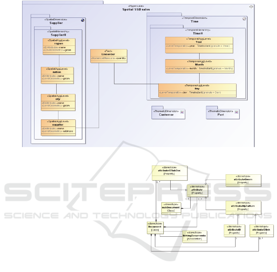
Figure 1: Case study DW: SSB conceptual model.
stereotypes are shown on Figure 2.
A <<Document>> is an extension of a class, and
it is composed of a set of attributes. These attributes
are attributes with particular data types:
<<attributeAlphanum>> for alphanumeric data type
(and no type), <<attributeGeom>> for spatial types
and <<attributeIDSubDoc>> for
<<subDocument>> data. Indeed, a document can be
composed of many subdocuments, which are
represented by the class stereotype
<<subDocument>>. Moreover, a document is
composed of an <<attributeID>> identifier attribute.
When a document is associated to another one it
contains an attribute <<attributeIDlink>> that is a
pointer to the <<attributeID>> attribute of the other
document. The association between these documents
is stereotyped <<linkingDocuments>>.
An example of OCL constraints is:
(type.oclIsUndefined() = false) and
(type.oclIsTypeOf(subDocument))
It states that the type of an
<<attributeIDSubDoc>> attribute must be a
subdocument.
Figure 2: Document database: metamodel.
Finally, let’s detail the type of the attributes of the
documents. Since geometrical attributes have a
particular representation in document DBMSs, we
have defined three spatial data types: P
OINT, LINE and
R
EGION. Other spatial type could be defined.
Therefore, using the following OCL statement, we
constraints an <<attibuteGeom>> attribute to have a
spatial type:
(type.oclIsUndefined() = false) and
(type.name=’Point’ or
type.name=’Region’ or
type.name=’Line’)
ICEIS 2017 - 19th International Conference on Enterprise Information Systems
346
(a)
(b)
(c)
Figure 3: Falling Star: a) metamodel, b) model, c) instances.
Moreover, since document DBMSs do not
support data type, we allow the OCL constraint
type.oclIsUndefined()for
<<attributeAlphanum >> attributes.
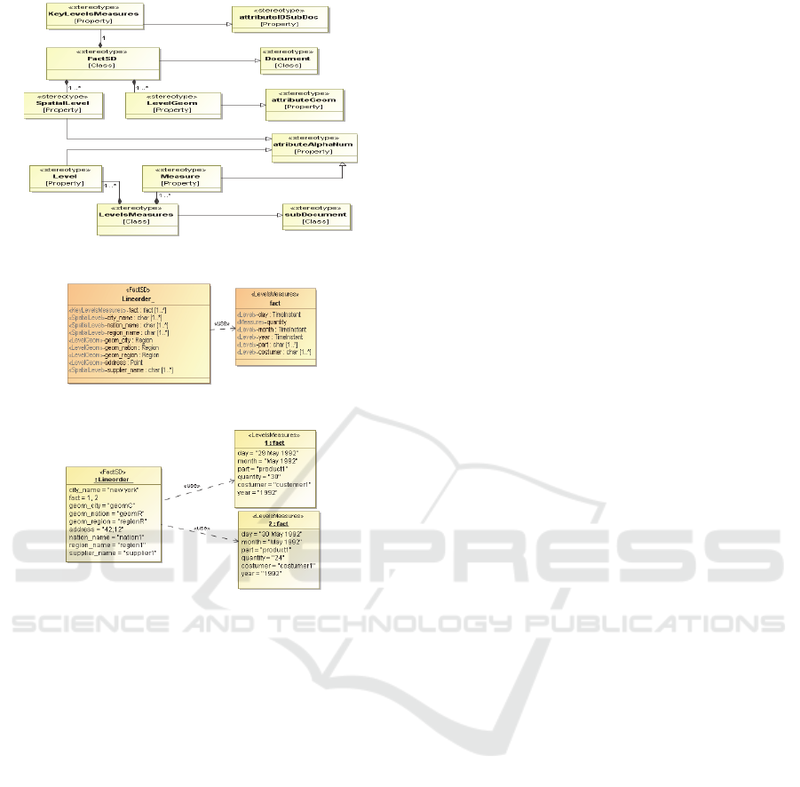
4.2 Falling Star
Motivated by the good computation performance of
the 1 collection approach, and trying to the spatial
data redundancy issues (Siqueira et al., 2010), we
describe in this section our new document spatio-
multidimensional logical model, named Falling Star
model. The main idea is to represent all facts with the
same spatial member by a single document. It means
that the list of measures and non-spatial dimension
members are associated to each spatial member.
Our proposed model avoids spatial data
redundancy. Indeed, spatial objects are complex
objects that require important storage size. For
example, the representation of a country at a high
resolution can use millions of points. Falling Star is
based on the previous UML profile for document
database described in Section 4.1.
The UML profile for this approach is represented
in Figure 3a. We represent a fact with the
<<FactSD>> stereotype which is composed of
spatial levels (<<SpatialLevel>>) and their
geometries (<<LevelGeom>>). Moreover, it
presents an array attribute of <<LevelsMeasures>>
type (<<KeyLevelsMeasures>>).
<<LevelsMeasures>> is a subdocument
composed of a set of measures and non-spatial levels.
<<FactSD>> is a document (it extends
<<Document>>), and <<LevelsMeasures>>
extends <<subDocument>>. <<SpatialLevel>> and
<<Level>> are the name of the spatial and non-
spatial levels respectively, and thus they extend
<<attributeAlphaNum>>.
Since <<LevelGeom>> represents geometry, it
extends <<attributeGeom>>. An example of OCL
constraint is:
self.ownedMember->select (m |
m.oclIsTypeOf(attributeIDlink))-
>size()=0
It states that a fact is not associated to other
documents, then it does not contain
<<attributeIDlink>> attributes.
As an example, our case study SDW is shown in
Figure 3b. A document
LINEORDER represents the
facts with attributes representing spatial levels names
(
CITY_NAME, REGION_NAME, etc.) and geometries
(GEOM_CITY, GEOM_REGION, etc.).
L
INEORDER has a set of subdocuments (via the
<<KeyLevelsMeasures>> fact attribute). FACT has
<<Level>> attributes for all non-spatial dimensions
(e.g.
DAY, MONTH, YEAR, PART, etc.) and
<<Measure>>
QUANTITY.
An example of instances is shown on Figure 3c,
where the ‘Supplier1’ is associated to two facts for
the two days ‘May29, 1992’ and ‘May30, 1992’. A
supplier is associated to one geometry. Let us note
that geometries are not repeated for each day.
Geometries are present only once for each supplier in
the instance of the class L
INEORDER.
5 IMPLEMENTATION
In this section, we present the implementation of our
UML profile using the CASE tool MagicDraw and
the implementation of our logical model using
document DBMSs.
MagicDraw is a CASE tool supporting UML
profiling mechanism with OCL constraints. OCL
constraints are automatically checked by MagicDraw
Design and Implementation of Falling Star - A Non-Redudant Spatio-Multidimensional Logical Model for Document Stores
347
when an instance of a UML profile is defined, and an
error message is displayed when necessary. By this
way, MagicDraw allows users to define only models
that are conform to the defined UML profile.
Since document databases are not based on a well-
accepted standard yet, to show the generality of our
implementation, we test it on two different document
DBMSs: MongoDB and CouchBase. However, due
to space limitation, we present in this paper only the
implementation on MongoDB. Instead of taking a
business subject and breaking it up into multiple
relational structures, MongoDB can store the business
subject in the minimal number of documents.
MongoDB documents are composed of attribute-
value pairs and have the following structure:
{attribute1: value1,
attribute2: value2,
…
attributeN: valueN }
All documents are stored in collections. A
collection is a group of related documents that have a
set of shared common indexes. MongoDB supports
search by field, range queries, regular expression
searches. Queries can return specific fields of
documents and also include user-
defined JavaScript functions. Therefore, using
MongoDB, we have implemented the SDW of Figure
3b as a collection composed of a set of documents.
The number of documents is the number of the spatial
dimension members. Each document is composed of
two parts. The first one is composed of 4 pairs of
key/value where key is an attribute representing
spatial level and value is geometric. The second part
is an array of subdocument called "Fact" that presents
<<LevelMeasure>>. Each subdocument is
composed of 48 attributes: 11 of which are measure
attributes from the fact, and the others come from all
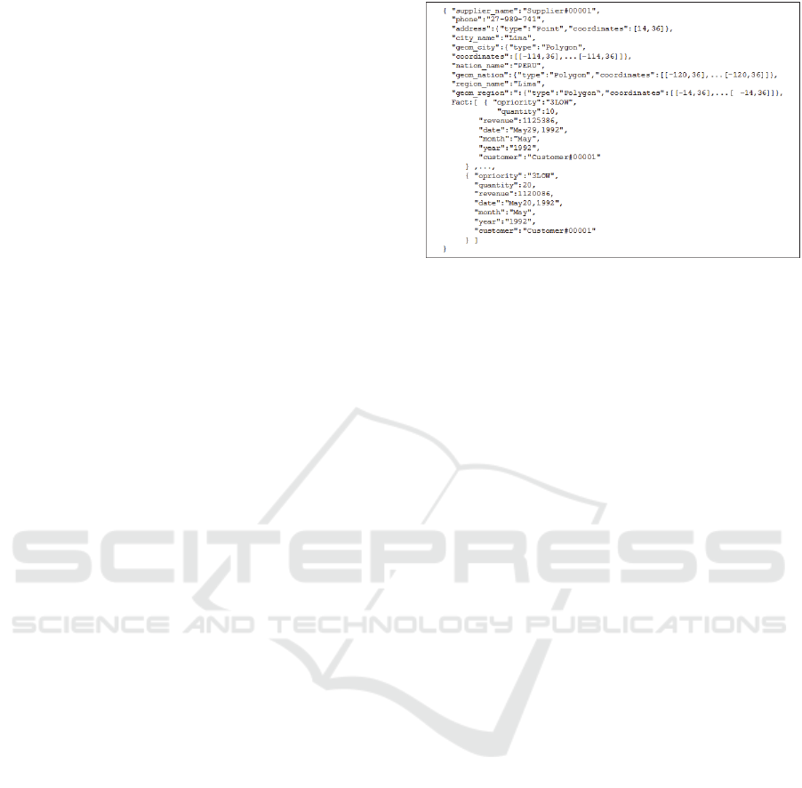
other non-spatial dimensions levels. An example is
shown in Figure 4. We can note that geometric
attributes (geom_nation, geom_region, geom_city)
are stored only once, but they are associated to two
facts (one for 29 May, and another for 20 May). In
this way, spatial data is not redundant.
Using
MongoDB documents each document has a
maximum size of 16MB. This feature is important to
ensure that a single document cannot use excessive
amounts of RAM.
To deal with this problem, we have developed a
java ETL program that calculates the size of each
generated documents and splits it in several different
documents that repeat the attributes of the spatial
levels.
Figure 4: Falling Star implementation in MongoDB.
Let us note that, in the same way of relational
DBMS, logical models must be adapted to fit with the
DBMS’s implementation. We have implemented the
queries of Section 3 using native MongoDB query
language. For example, the query Q4b (
Spatial slice
with query window) is rewriting as following:
db.falling_star.aggregate (
{ $match : {"geom_region" :
{ $geoWithin:{$polygon: [[-5000,-5000],[-
5000,5000],[5000,5000],[5000,5000]]}}}},
,{$unwind : "$Fact"} ,
{ $group : { _id:null,
total: {$sum : "$Fact.revenue"} } );
6 EXPERIMENTS
In this section, we evaluate our proposal and compare
it to existing logical models for document data
warehouses. In particular, we evaluate our model with
Spatial SSB data (Siqueira et al., 2010). Spatial SSB
extends the SSB benchmark to support SOLAP
queries with spatial predicates, such as intersection,
containment queries. Motivated by the lack of
benchmark for spatial big DW (Chevalier et al., 2015)
(Dehdouh et al., 2015), we have modified Spatial SSB
to write generated data on MongoDB using the
Falling Star Schema. In particular, it generates a
GeoJson file, which is loaded in MongoDB.
Data is generated using different scale factors (sf),
namely sf=1, sf=10, sf=20, sf=50 and sf=100 in our
experiments. The scale factor sf=1 generates
approximately 6*10
6
facts and 10,000 suppliers, for
sf=10 we have approximately 6*10
7
facts and 100000
suppliers and so on. We have generated for the
geometries of spatial levels polygons composed of
10,000 points.
ICEIS 2017 - 19th International Conference on Enterprise Information Systems
348
6.1 Storage Performance
We have compared our approach to the existing “1
collection” MLD0 model (since as previously
described in Section 2.1 there is no difference
between the MLD0 and the MLD1).
In particular, we have extended the logical model
MLD0 presented in (Chevalier et al., 2015). MLD0
stores data in one collection, where each document
presents an attribute for each level. We have added to
MLD0 geometrical attribute. We can note that for
each fact (each document) the geometries of spatial
levels (polygons composed of 10,000 points) are
repeated.
We have compared our proposal and the
extension of MLD0 under two aspects: data storage
and query execution time. Experiments were
conducted on a virtual machine with a 6 VCPU, 32
GB of main memory, a 9 TB hard disk, Windows
Server 2012, and MongoDB 3.2. Finally, we do not
provide any indexes on our data, since the main goal
of this work is to compare logical models.
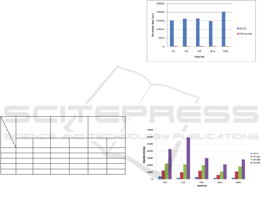
We present in Table 1, the database size of both
logical models without and with spatial data. For sf=1
the redundant geometries of the MLD0 model are the
responsible of the huge size of the database.
Table 1: Size and loading time of data by the scale factor.
Data size
without spatial
data (GB)
Data size with
spatial data
(GB)
Data loading
time
(sec)
MLD0 Falling
star
MLD0
Falling
star
MLD0 Falling
star
sf =1 5.5 5 320 6 1290 326
sf=10 58 51 3000 60 12679 2730
sf=20 112 102 6000 120 20784 5212
sf=50 295 250 15000 280 26413 12480
sf=100 570 500 30000 3000 45213 34320
Indeed, geometries represent 314.5 GB of a 320
GB total size. For bigger sf, the SDW size is bigger.
Due to the lack of hard disk space, we estimate the
size of the SDW generated by MLD0 from sf=10,
thus 10, 20, 50 and 100. Therefore, we can conclude
that the spatial data redundancy is the main factor of
the huge size of the SDW in the MLD0 model. This
is not true for the Falling Star model, where since
geometries are not redundant, they do not affect
considerably the total size of the SDW. We observe
that MLD0 needs more disk space than Falling Star,
because MLD0 repeats spatial attributes values on
every document. For instance, at scale factor sf=10
(6*10
7
facts), Falling Star needs 6GB while MLD0
needs 320 GB space. We summarize also in Table 1
data loading time by scale factor. Data is loaded into
MongoDB using native instructions. By
consequence, experiments also confirm that Falling
Star is also better in terms of data loading time.
6.2 Query Performance
In the following, we analyse query execution time
performance for 5 queries of our case study. We
perform these queries only under the instance of
MLD0 with sf=1 since MLD0 is not feasible in terms
of storage as shown in Sec 6.1.
Figure 5: Execution time by model.
Figure 5 shows that Falling Star is better than
MLD0 for all queries. This is explained by the small
quantity of data, of Falling Star with respect to
MLD0. Indeed, the redundancy of the geometries in
MLD0 affects query execution time. Therefore, for
query performance, Falling Star is acceptable
contrary to MLD0.
Figure 6: Execution time by SOLAP query.
Let’s consider the query time of the SOLAP
queries of Sec 3 for Falling Star (Figure 6).
Performance is inversely proportional to the size of
the SDW. However, query execution time remains
acceptable for our PC configuration. Moreover, let’s
note that execution time of spatial slice queries (Q4a
and Q4b) is better than the execution time of other
queries. This is due to the fact that, contrary to
alphanumeric attributes, MongoDB can directly
retrieve the documents with the right spatial members
since with Falling Star they are represented as normal
attributes. Indeed, non-spatial levels are represented
with alphanumeric attributes inside an array structure;
therefore, MongoDB must load all the documents
Design and Implementation of Falling Star - A Non-Redudant Spatio-Multidimensional Logical Model for Document Stores
349

before to unwind the arrays to look for the right non-
spatial members.
7 CONCLUSION AND FUTURE
WORK
In the Spatial Big Data field, many academic and
industrial communities propose new Spatial DBMSs,
(such as MongoDB, Cassandra, etc.) to handle with
the volume and the variety of these very huge
georeferenced datasets. In particular, document
Spatial DBMSs appear well-adapted to store complex
and voluminous spatial data. Despite of important
spatial analysis possibilities offered by document
Spatial DBMSs, no work investigates their use in the
context of Spatial OLAP and Spatial Data
Warehouse.
Therefore, in this work, we focus on the logical
modelling and query processing of document spatial
data warehouse. We propose a new logical schema for
Spatial DW using UML profile. We generate datasets
of different size according to different scale factor
values. We have tested our models under MongoDB.
Our experimental work shows that Falling Star model
is better than existing models for document data
warehouses, since it explicitly takes into account
spatial data.
On-going work involves comparing Falling Star
with different logical implementations (relational or
NoSQL) and testing our models in a distributed
architecture. We will also analyze the impact of query
selectivity on the performance of Falling Star model.
REFERENCES
Abdelhédi, F., Ait Brahim A., Atigui, F., Zurfluh G., 2016.
Processus de transformation MDA d'un schéma
conceptuel de données en un schéma logique NoSQL.
INFORSID, pp 15-30.
Bimonte, S., Kang, M., Trujillo, J., 2013. Integration of
Spatial Networks in Data Warehouses: A UML
Profile. Int Conf. on Computational Science and Its
Applications (ICCSA), pp 253-267.
Boulil, K., Bimonte, S., Pinet, F. 2015. Conceptual model
for spatial data cubes: A UML profile and its automatic
implementation. Computer Standards & Interfaces
(38), pp 113-132.
Chevalier, M., El Malki, M., Kopliku, A., Teste, O., and
Tournier, R., 2015. Implementation of
Multidimensional Databases with Document-Oriented
NoSQL. Int Conf. on Big Data Analytics and
Knowledge Discovery (DaWaK), pp 379-390.
Cuzzocrea, A., Fidalgo, Robson, do N. 2012. Enhancing
Coverage and Expressive Power of Spatial Data
Warehousing Modeling: The SDWM Approach. Int
Conf. on Big Data Analytics and Knowledge
Discovery (DaWaK), pp 15-29.
Dehdouh, K., Bentayeb, F., Boussaid, O., and Kabachi, N.,
2015. Using the column oriented NoSQL model for
implementing big data warehouses. Int Conf. on
Parallel and Distributed Processing Techniques and
Applications (PDPTA), pp 469-475.
Gwendal, D., Gerson, S., and Jordi, C., 2016. UML to
GraphDB: Mapping Conceptual Schemas to Graph
Databases. Int Conf, on Conceptual Modeling ER,
Springer International Publishing, pp 430-444.
Kimball, R., Ross, M. 2002. The Data Warehouse Toolkit:
The Complete Guide to Dimensional Modeling. John
Wiley & Sons, Inc., New York, NY, USA, 2
nd
edition.
Li, Y., Gu, P., Zhang, C,. 2014. Transforming UML Class
Diagrams into HBase Based on Metamodel. Int Conf.
on Information Science, Electronics and Electrical
Engineering, pp 720-724.
Lutz, R., Ameri, P., Latzko, T., Meyer, J, 2014.
Management of meteorological mass data with
MongoDB. Proceedings of the 28th EnviroInfo
Conference.
Mazón, J-,N., Trujillo, J., Serrano, M., Piattini, M. 2005.
Applying MDA to the development of data
warehouses. DOLAP, pp 57-66.
Oueslati, w., Akaichi, J. 2014. Trajectory data warehouse
modeling based on a Trajectory UML profile: Medical
example. Int Work-Conf. on Bioinformatics and
Biomedical Engineering (IWBBIO), pp 1527-1538.
Filho, WB., Olivera, H V., Holanda, M., Favacho, A A.
2015. Geographic Data Modeling for NoSQL
Document-Oriented Databases. GEOProcessing 2015 :
Int Conf. on Advanced Geographic Information
Systems, Applications, and Services, pp 63-68.
Shekhar, S., Gunturi, V., Evans, M. R., and Yang, K., 2012.
Spatial Big-Data Challenges Intersecting Mobility and
Cloud Computing. Proceedings of the 11
th
ACM Int
Workshop on Data Engineering for Wireless and
Mobile Access -MobiDE, p. 1.
Siqueira, TLL., Ciferri, RR., Times, VC., and Ciferri,
CDA. 2008. Investigating the Effects of Spatial Data
Redundancy in Query Performance over Geographical
Data Warehouses. GeoInfo, pp 1-12.
Siqueira, TLL., Ciferri, RR., Times, VC., and Ciferri,
CDA, 2010. Benchmarking Spatial Data Warehouses »,
in Data Warehousing and Knowledge Discovery, vol.
6263, Springer Berlin Heidelberg, 2010, pp 4051.
Xiang, L., Huang, J., Shao, X., Wang, D, 2015. A
MongoDB-Based Management of Planar Spatial Data
with a Flattened R-Tree, ISPRS Int J Geo-Information,
vol. 5, nᵒ 7, p. 119.
Zhang,X., W. Song, et L. Liu, An implementation approach
to store GIS spatial data on NoSQL database, 2014, pp
15
ICEIS 2017 - 19th International Conference on Enterprise Information Systems
350
