
Metamodeling Approach for Hazard Management Systems
Anca Daniela Ionita
1
and Mariana Mocanu
2
1
Department of Automation and Industrial Informatics, University Politehnica of Bucharest,
Spl. Independentei 313, 060042, Bucharest, Romania
2
Department of Computing Science, University Politehnica of Bucharest,
Spl. Independentei 313, 060042, Bucharest, Romania
Keywords: Metamodeling, Modeling Environments, Hazard Management.
Abstract: The management of natural and human-caused hazards is performed by reuniting a large variety of
stakeholders, non-homogeneous collections of data, and systems that may not have been conceived for
interoperability. The interdependency between hazards and the need of coordinated response also lead to the
necessity to develop multi-hazard solutions, resulting in systems with a high complexity. This paper presents
a metamodeling approach for hazard management systems, and a specific modeling environment, which
considers the hazard, emergency, and geospatial views. The use of the model editor is exemplified on a system
for early warning in case of accidental water pollution.
1 INTRODUCTION
Model Driven Engineering (MDE) may represent a
solution for managing complex systems (Hossu et al.,
2009) and coping with some of their critical
properties, like size, heterogeneity, or the autonomy
of their components (Bézivin et al., 2008).
Furthermore, MDE was also found useful in case
these complex systems are resulted from the
integration of several legacy systems (Clavreul,
Barais & Jézéquel, 2010).
This paper is focused on a kind of complex
systems developed for prevention, early warning, and
emergency action in case of natural or human-caused
hazards. There have been several attempts to specify
generic architectural frameworks for hazard
management systems. Yet, there is no initiative of
standardization that is independent of the type of
hazard; the operating frameworks are preponderantly
focused on a single hazard.
An important step towards unification within this
domain was realized through the scientific reviews
containing comparative analyses, according to
criteria like: alarm levels, risk classes, event severity
and likelihood, remaining time to hazard occurrence
or arrival in the studied area (Villagrán de León,
Pruessner, & Breedlove, 2013). There were also
several attempts to specify frameworks generally
appropriate for early warning systems, by defining
guiding principles, stakeholders, preconditions, and
strategies (UNDP, 2013). The United Nations
adopted The Sendai Framework for Disaster Risk
Reduction 2015-2030 (UNISDR, 2015) where
priorities are specified at national and local levels.
At the technical level, diverse modeling
approaches have been experienced, like the IDEF0
function modeling methodology and the EXPRESS
language for data modeling (Fortier & Dokas, 2008).
Variants for specific monitoring solutions like
crowdsourcing also exist in the literature (Meissen &
Fuchs-Kittowski, 2014). A very important progress
has been made with the INSPIRE European directive
regarding the spatial data infrastructure, meant to
support interoperation at the level of data, metadata,
monitoring and reporting (Bartha & Kocsis, 2011).
Still, there is no reference architecture for this
domain, to increase the degree of reusability and to
support the integration of existing systems.
The work presented here resulted in the definition
of a metamodel and a modeling environment for the
architecture of hazard management systems. Our
research started with the identification of common
and specific artefacts for hazard management
systems, first for our research projects, then for other
examples described in the publicly available
documentation: systems in use, prototypes,
conceptual frameworks etc. This led to the definition
of a metamodel and of a modeling environment, used
Ionita, A. and Mocanu, M.
Metamodeling Approach for Hazard Management Systems.
DOI: 10.5220/0006417702570264
In Proceedings of the 12th International Conference on Software Technologies (ICSOFT 2017), pages 257-264
ISBN: 978-989-758-262-2
Copyright © 2017 by SCITEPRESS – Science and Technology Publications, Lda. All rights reserved
257
for representing a variety of existing systems, and
upgraded to support all the required links between
artefacts, and to offer multiple views.
Section 2 presents the research method applied for
metamodeling the hazard management domain.
Section 3 explains the modeling paradigm – the
metamodel and the hazard-specific modeling
environment, which is applied for representing a
water pollution early warning system.
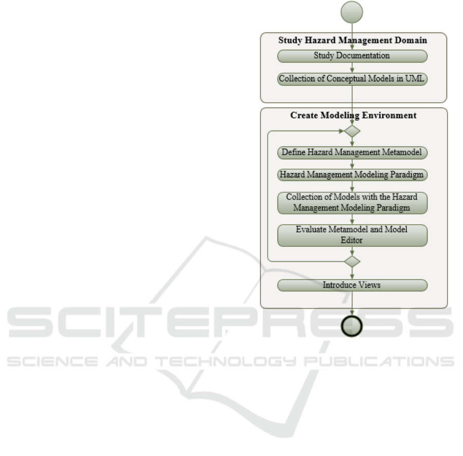
2 RESEARCH METHOD
2.1 Study Hazard Management
Domain
2.1.1 Study Documentation
The first step of our research, Study Documentation
(see Figure 1), consisted of:
Documenting the architecture of two hazard
management systems developed in research
projects we were involved to, the former for
accidental river pollution (Ionita & Mocanu,
2015), and the latter for territorial
vulnerabilities induced by nuclear facilities
(N-WATCHDOG, 2017);
Analyzing existing ontologies for hazards or
vulnerabilities, like VuWiki (2016);
Studying survey documents, including
exhaustive classifications of hazards and a
large set of examples that describe the current
state of practice, e.g. (UNEP, 2012);
Comparing the technology and the
functionality through the examination of public
documentation about systems in use for:
disseminating alerts, e.g. Mobile Emergency
Alert Systems (MEAS) (Park, Choi & Seo,
2014), and for early warning, e.g. (Kaku &
Held, 2013);
Studying scientific papers that propose new
solutions and / or integratory approaches for the
domain; our search was focused on multi-
hazard systems and generic frameworks, e.g.
(Balis et al., 2011);
Looking for standards that have to be respected
when implementing this kind of systems, e.g.
INSPIRE or Common Alerting Protocol (CAP)
(OASIS, 2010).
2.1.2 Collection of Conceptual Models
For a selection of the systems mentioned above, the
study included:
Figure 1: Research Method.
Identification of the most important artifacts,
i.e. modules, devices, stakeholders, concepts,
with their relevant properties and functionality;
Identification of dependencies between the
artifacts mentioned above.
They were used to create a Collection of
Conceptual Models in UML (Unified Modeling
Language). UML was selected because it is a general-
purpose modeling language, and it is object-oriented,
similarly to the metamodel we were going to define.
The collection currently contains about fifty models.
2.2 Create Modeling Environment
The steps for creating the modeling environment,
presented below, were reiterated several times, for
being capable to model all the studied systems.
2.2.1 Define Hazard Management
Metamodel
Define Hazard Management Metamodel was the first
step that succeeded the Study of Hazard Management
ICSOFT 2017 - 12th International Conference on Software Technologies
258

Domain. It started with a collaborative session, where
several persons who studied examples of hazard
management systems presented them to their
colleagues. Each example was accompanied by a
UML class diagram, showing the most important
elements necessary to characterize that system. The
goals of a collaborative session were:
to identify the concepts that are common within
the conceptual models;
to make lists of terms with similar meaning;
for each list, to find a term that abstracts the
meaning of all the concepts within that list;
to identify common properties of these
concepts;
to identify common relationships between
them.
Afterwards, these elements were used for a first
representation of the hazard management systems
metamodel, based on the notation of UML class
diagrams. This makes sense, as MOF (Meta Object
Facility), the metamodel of UML, also uses the UML
concrete syntax for its specification.
2.2.2 Hazard Management Modeling
Paradigm
For creating modeling tools, we used Generic
Modeling Environment (GME) (2017) and we built
the Hazard Management Modeling Paradigm.
In the GME vocabulary, a paradigm is equivalent
to a modeling language for the given application
domain - in our case for hazard management systems.
Thus, we formalized the abstract syntax, by mapping
the UML metamodel (resulted at 2.2.1) to the
metamodeling language supported by GME, i.e.
compositions remained the same, associations
became GME Connections, and classes became either
Atoms or Models.
The concrete syntax of the language was also
defined, by introducing icons specific to the new
metamodel objects. They were used for configuring
the model editor generated from the paradigm.
2.2.3 Collection of Models with the Hazard
Management Modeling Paradigm
The editor was used for obtaining the Collection of
Models with the Hazard Management Modeling
Paradigm, i.e. all the models of systems initially
represented with a general modeling language, UML,
were transformed into GME models, conforming to
the new paradigm / metamodel. In practice, they did
not correspond to a single version of the paradigm, as
it was upgraded over several iterations.
2.2.4 Evaluate Metamodel and Model Editor
The representation of models gave the opportunity to
get to the next step: Evaluate Metamodel and Model
Editor. The attempt to use the first version of a
modeling language is not always successful; this is
the moment to discover whether:
a connection is missing;
a modeling element has not been associated to
an aspect and therefore it is not visible;
two objects that should be connected belong to
metamodel classes from different
encapsulation levels;
a part has not been included into a model;
there are properties or concepts that cannot be
instantiated from the existing metamodel, so
new elements should be included.
Therefore, new versions of the modeling
environment were necessary, and the steps for
creating the modeling environment were re-iterated.
2.2.5 Introduce Views
The idea was to organize the architectural artefacts
following the example of Enterprise Architecture
(EA), considered as “Information Systems
Architecture”. The reasons why a hazard
management system can be addressed within the EA
field are: the necessity to have a holistic approach,
and the challenge of complex IT systems and
organizational structures to meet business goals
(Sessions, 2007).
As in hazard management, the fields of interest in
EA cover more than software development, usually
approached with view models (May, 2005). In the
Zachman Framework classification (Zachman, 2016),
the design artefacts are organized as a matrix, where
the rows correspond to perspectives that represent the
viewpoints of diverse stakeholders, including
planner, owner, operator etc. Although Zachman talks
about “views” and “aspects” without associating
them with precise semantics, a perspective
corresponds to an architectural viewpoint that
governs an architectural view, composed of one or
more architecture models, as defined by the
ISO/IEC/IEEE 42010 standard (2011). Still within
EA, the Treasury Enterprise Architecture Framework
(TEAF) also included Functional, Information,
Organizational and Infrastructure views
(Urbaczewski & Mrdalj, 2006), which might be of
interest for hazard management too.
Therefore, we looked for a framework that can
depict the hazard management systems in a similar
way, and group the metamodel abstract concepts. We
identified three important views:
Metamodeling Approach for Hazard Management Systems
259
Hazard View – embracing the concerns about
the hazard itself, with its specific physical
phenomena, theory, mathematical tools and
techniques; this view should contain models for
data collections, prediction, decision support
and acquisition;
Emergency View – regarding the viewpoint of
the emergency professionals, who have to
monitor the risk and take actions when
necessary; it includes representations of the
warning software and of the warning devices;
GIS View - concerning geospatial distributions,
collections of data, and visualization
capabilities; for this view, one needs models for
Geographical Information Systems (GIS) and
Global Positioning Systems (GPS).
3 MODELING PARADIGM
3.1 Metamodel
The resulted metamodel contains a general part, for
modeling the architecture inside a hazard
management subsystem (as a graph of computing
units connected through their interfaces), plus three
parts that define specific models for the previously
identified views, Hazard, Emergency, and GIS (see
Section 2.2.5.) - and presented below.
We used the metamodeling language provided by
Generic Modeling Environment, where an Atom is an
indivisible modeling element, and a Model can
contain other GME elements, to which it is connected
through a line starting with a black diamond. An
association that is not a containment is a Connection.
The notation is similar to UML class diagrams.
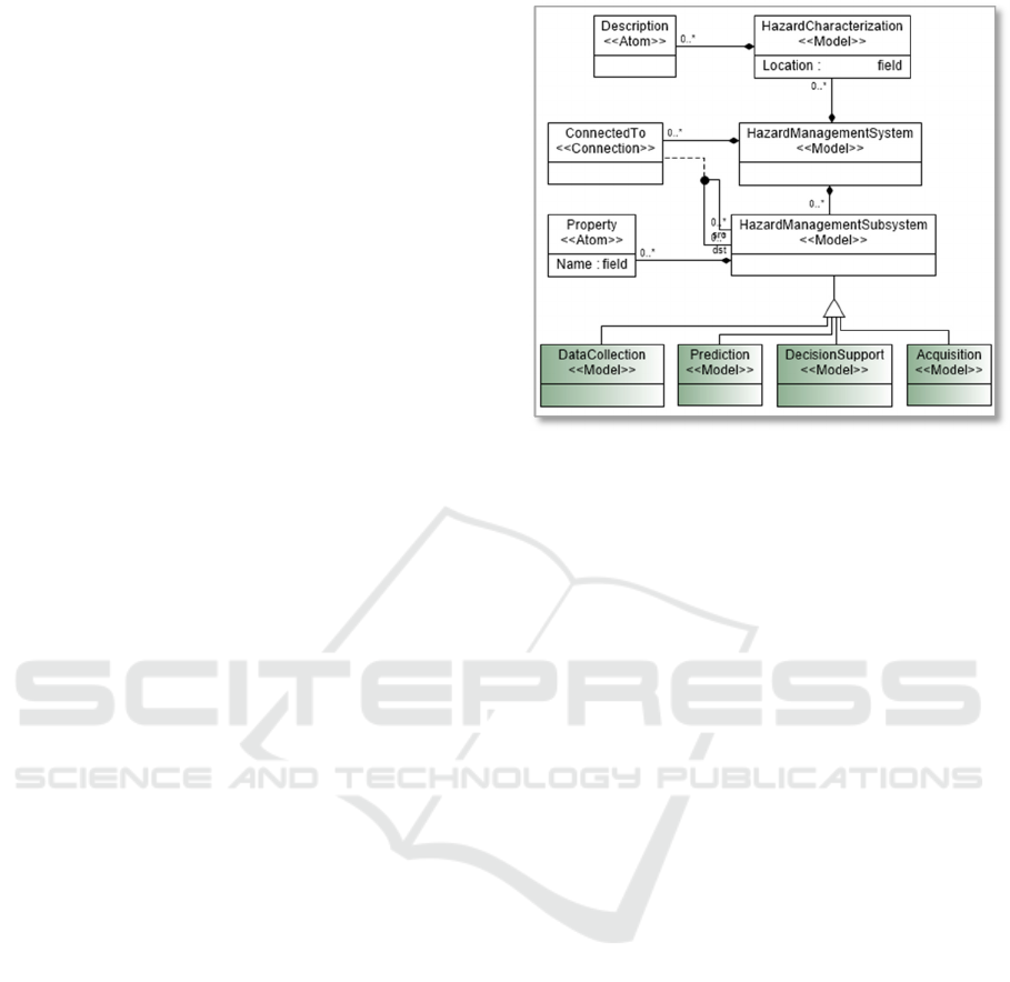
3.1.1 Hazard View
The abstract syntax for the Hazard view, represented
in Figure 2, considers that a hazard management
system is composed of a model that characterizes the
hazard, and of multiple models, correspondent to
subsystems specific for managing the hazard,
connected to each other.
Our study led to the identification of four kinds of
models, all derived from
HazardManagementSubsystem:
Data Collection, corresponding to: assemblies
of historical data on hazard events or
demographic data, results of the vulnerable
regions monitoring, scientific data, etc.;
Figure 2: Metamodel for the Hazard View.
Prediction, for subsystems that model the
physical phenomena that drive the hazard and
introduce predictive functionality;
Acquisition, containing data acquisition
subsystems, whose outputs are afterwards
stored into Data Collection subsystems; they
may be measuring devices, sensor networks,
satellites etc. (Ionita & Olteanu, 2014);
Decision Support, with units that analyze the
available data and recommend predictive or
response actions, which are transmitted to the
subsystems pertaining to the Emergency view.
3.1.2 Emergency View
The abstract syntax for the Emergency view (see
Figure 3) introduces two other kinds of models:
Warning Software – meant for the efficient
management of notifications sent to various
actors and organizations, which represent
potentially affected parts of emergency
personnel; a Notification can be of type:
Information, Warning, Alert, Red Alert, in
respect with the severity of the hazard event;
Warning Device – i.e. television set, radio set,
telephone, computer, speaking-tube etc.
The organizations authorized to deal with
emergency situations generally respect very strict
processes; that is why the metamodel also contains an
Activity model, with types that are specific to the
emergency life cycle: Preparedness, Response,
Recover and Mitigation, according to the
classification adopted by the Federal Emergency
Management Agency (FEMA) (Lindsay, 2012).
ICSOFT 2017 - 12th International Conference on Software Technologies
260
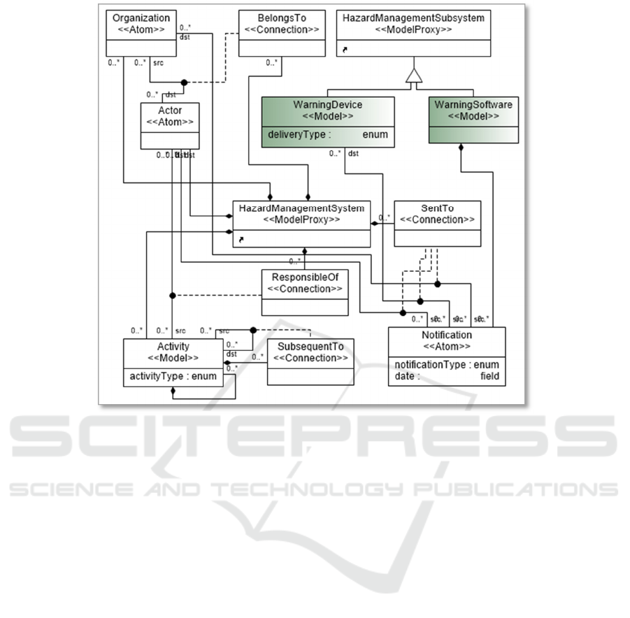
Figure 3: Metamodel for the Emergency View.
3.1.3 GIS View
For the GIS view, the metamodel introduces two
models derived from HazardManagementSubsystem:
GeographicalInformationSystem, which may
contain ComputingUnit and DataStore objects,
necessary for processing geospatial data and
for representing geological, hydrological, or
topological maps;
GlobalPositioningSystem, for the physical
system that provides geolocation data.
3.2 Hazard-Specific Environment
3.2.1 Modeling Editor
The metamodel, represented as a GME paradigm, was
interpreted to generate a specific modeling editor for
hazard management systems. For the configuration of
its concrete syntax we introduced specific icons for
all the metamodel elements described at 3.1. (see the
Part Browser on the left side of Figure 4).
For each of the GME objects of type Model, like
Prediction, Acquisition etc., the editor allows one to
open a new tab with an editing pane, and represent a
diagram for its internal structure, which is thus
encapsulated; an exception was made for the objects
of type Interface, which appear on the upper level, as
ports. Thus, the editor supports several levels of
encapsulation for describing a model.
For implementing the Hazard, Emergency, and
GIS views, we introduced and configured three
specific aspects; an Aspect is a GME concept used for
controlling the modeling elements visibility. Thus, it
is possible to draw the diagrams separately for each
aspect (Hazard, Emergency, and GIS), to reduce the
model complexity and allow a domain expert to see
just the concepts for the correspondent viewpoint.
Afterwards, if one gets to the General aspect, it is
possible to see the entire model and to make
connections between objects from different views.
3.2.2 Example of Model
Figure 4 presents a model edited with the hazard-
specific environment, for a prototype that monitors
the water quality of a river and recommends decisions
to be taken in case one detects an accidental pollution
(Ciolofan et al., 2013).
Metamodeling Approach for Hazard Management Systems
261
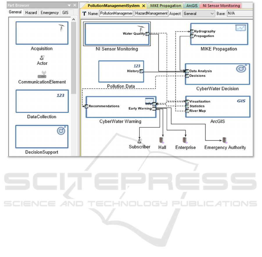
Figure 4: Pollution Management System Represented with the Hazard Management Editor.
The image presents the General aspect, but the
model was realized as follows. Within the Hazard
aspect, there are the following subsystems:
NI Sensor Monitoring – a model of kind
Acquisition, representing a wireless sensor
network with a star topology, realized with
National Instruments components, meant to
collect surrogate data to be further processed
for estimating the values for a set of physical
quantities;
MIKE Propagation – a model of kind
Prediction, corresponding to a subsystem
based on the MIKE environment (2017),
capable to calibrate and execute the model for
the propagation of a pollutant downstream; the
purpose is to predict the moment a pollutant
arrives at the localities downstream and what is
its concentration; its inputs are real data on the
shape of the river bed, and on the initial
location of the pollutant detection;
CyberWater Decision – a model of kind
DecissionSupport, containing a rule engine and
storing a collection of rules, activities, and
threshold values; the decisions depend on the
water quality detected by the sensor network,
the predictions resulted from the simulations
with MIKE, and the historical data;
Pollution Data – a model of kind
DataCollection, comprising data about
previous pollution events in the area of interest.
Then, for the Emergency aspect, the metamodel
contains:
CyberWater Warning – a model of kind
WarningSoftware, meant to transmit
notifications towards private subscribers,
organizations that represent local authorities,
(e.g. village halls), industrial players (i.e.
enterprises whose activity may be affected by
the pollution) and, last but not least, to
organizations that have the authority to take
action in case of emergency situations;
Enterprise, Hall, and Emergency Authority –
atoms of kind Organization, receiving
notifications from the warning subsystem;
Subscriber – atom of kind Actor, representing
a person that receives early warning
notifications.
In the GIS aspect, we represented:
ArcGIS – a GeographicalInformationSystem
model, containing ArcToolbox, ArcCatalog
and ArcMap (with the hydrographic basin
maps) and exposing interfaces for
visualization, statistics, and geospatial data
related to the river.
ICSOFT 2017 - 12th International Conference on Software Technologies
262
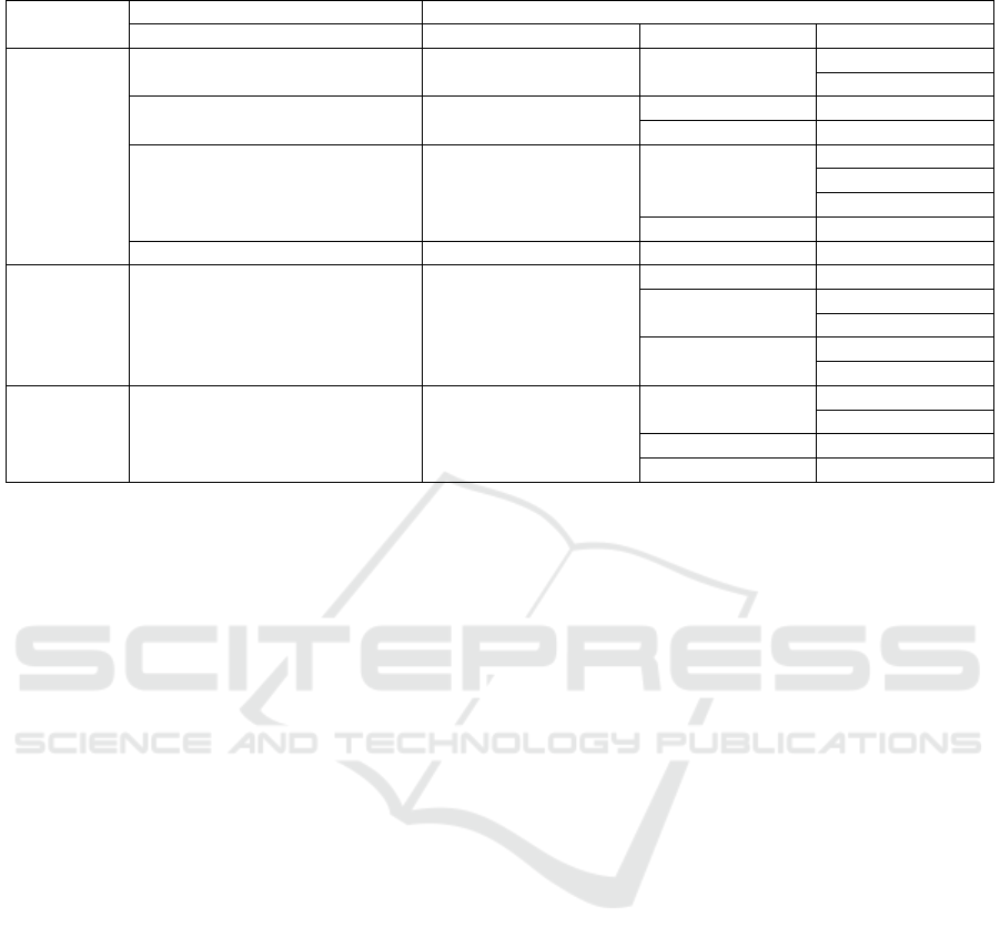
Table 1: Summary of the objects of type Model, from the model represented in GME with the HazardManagement paradigm.
Aspect
Metamodel Level Model Level
Kind Model Port Connected Port
Hazard
Acquisition NI Sensor Monitoring Water Quality
Visualization
Data Analysis
Prediction MIKE Propagation
Hydrography River Map
Propagation Data Analysis
DecisionSupport CyberWater Decision
Data Analysis
Water Quality
History
Propagation
Decisions Recommendations
DataCollection Pollution Data History Data Analysis
Emergency
WarningSoftware CyberWater Warning
Recommendations Decisions
Early Warning
Subscriber
Hall / Enterprise
Info
Statistics
Visualization
GIS
GeographicalInformationSystem ArcGIS
Visualization
Water Quality
Info
Statistics Info
River Map Hydrography
Each of these subsystems is a model whose
structure is represented inside and is not visible at the
first level, except from the interfaces. Thus, in the
General aspect we also connected interfaces of
subsystems defined in different views. For instance,
the Hydrohraphy interface from MIKE_Propagation
- a model of type Prediction, which is part of the
Hazard view - depends on the RiverMap interface of
ArcGIS - a model from the GIS view. These
connections are represented with dotted lines.
Table 1 summarizes the most important elements
of this model, with their components that are visible
as ports, and the ports from other models they are
connected to. For each aspect, it presents the main
objects of type Model (in the GME metamodeling
language), with the metamodel entities they were
instantiated from (i.e. the Kind in GME).
Note that the connections that transverse the
views are easier to visualize in the GME diagram than
in the tabular form. Moreover, one can select one of
the three aspects, and visualize exclusively the parts
of the model that correspond to them, thus obtaining
a simplified diagram, and having the opportunity to
reflect on further details that need to be represented.
4 CONCLUSIONS
For managing natural or human-caused hazards, there
is a large variety of systems in place, and the trend is
to introduce new infrastructure for monitoring the
environment, and more efficient support for
transmitting notifications when an undesired event
happens. There is an increased interest to make
exiting systems interoperate and to manage multiple
types of hazards in an integrated way. This leads to
the increase in complexity and non-homogeneity.
The paper proposed a metamodeling approach,
which identified types of artifacts that are recurrent
within hazard management systems, and used them
for defining a metamodel and for configuring a
specific modeling environment. The editor supports
several levels of encapsulation in the representation
of a hazard system, which is composed of various
kinds of models that can be further described in
separate diagrams, showing their inner parts and the
connections between them. We also introduced the
Hazard, Emergency, and GIS views, to reduce the
complexity of modeling; one can represent diagrams
correspondent to each view, and then visualize the
elements situated at the top level of encapsulation,
and introduce connections between them.
The approach has potential to be extended by
composition with other metamodels and by adding
model interpreters.
ACKNOWLEDGEMENTS
The work was realized within the Partnerships in
Priority Areas Program - PN II, supported by MEN-
UEFISCDI under the project number 298/2014.
Metamodeling Approach for Hazard Management Systems
263

REFERENCES
Balis, B, Kasztelnik, M, Bubak, M, Bartyński, T, Gubała,
T, Nowakowski, P. & Broekhuijsen, J. (2011) The
UrbanFlood Common Information Space for Early
Warning Systems. Procedia Computer Science. 4.
Elsevier, pp. 96-105. Available from: https://doi.org/
10.1016/j.procs.2011.04.011 [Accessed 14th May
2017].
Bartha, G. & Kocsis, S. (2011) Standardization of
Geographic Data: The European INSPIRE Directive.
European Journal of Geography, 2, 79-89.
Bézivin, J., Paige, R.F., Aßmann, U., Rumpe, B. &
Schmidt, D. (2008) Manifesto - Model Engineering for
Complex Systems. In: Dagstuhl Seminar Proceedings.
Perspectives Workshop: Model Engineering of
Complex Systems (MECS). Schloss Dagstuhl: Leibniz-
Zentrum fuer Informatik, Germany. Available from:
https://arxiv.org/abs/1409.6591 [Accessed 12th March
2017]
Ciolofan, S.N., Mocanu, M. & Ionita, A.D. (2013)
Distributed Cyberinfrastructure for Decision Support in
Risk Related Environments, In 12th International
Symposium on Parallel and Distributed Computing,
Bucharest, IEEE. pp. 109-115.
Clavreul, M., Barais, O. & Jézéquel, JM. (2010) Integrating
legacy systems with MDE, In: 32nd ACM/IEEE
International Conference on Software Engineering.
Cape Town: IEEE, pp. 69-78.
Fortier, S.C. & Dokas, I.M. (2008) Setting the Specification
Framework of an Early Warning System Using IDEF0
and Information Modeling. In: 5th International
ISCRAM Conference Information Systems for Crisis
Response and Management, Washington, D.C.:
ISCRAM, pp. 441-450.
GME (2017) Generic Modeling Environment. Available
from: http://www.isis.vanderbilt.edu/projects/ gme/
[Accessed 10th March 2017].
Hossu, D., Humaila, H., Mocanu, S. & Saru, D. (2009)
Complex networks to model the economic
globalization process, In: IFAC Proceedings Volumes,
42(25): Elsevier, pp. 62-67.
Ionita, A.D. & Olteanu, A. (2014). Domain specific models,
knowledge and tools to support multiple learning styles
for engineering students, Revue Roumaine des Sciences
Techniques – Série Electrotechnique et Energétique, 59
(4), 423-432.
Ionita, A.D. & Mocanu, M. (2015) Multiple Modeling
Paradigms Applied for Accidental Pollution
Management, Environmental Engineering and
Management Journal, 14(9), 2051-2060.
ISO/IEC/IEEE (2011). Systems and software engineering
— Architecture description. ISO/IEC/IEEE Standard
42010:2011.
Kaku, K. & Held, A. (2013) Sentinel Asia: A space-based
disaster management support system in the Asia-Pacific
region. International Journal of Disaster Risk
Reduction, 6, pp. 1–17.
Lindsay, B.R. (2012) Federal Emergency Management: A
Brief Introduction. Congressional Research Service.
Available from: https://fas.org/sgp/crs/homesec/
R42845.pdf [Accessed 18th March 2017].
May, N. (2005) A survey of software architecture viewpoint
models, In: Sixth Australasian Workshop on Software
and System Architectures. Brisbane, pp. 13-24.
Meissen, U. & Fuchs-Kittowski, F. (2014) Crowdsourcing
in Early Warning Systems. In: 7
th
International
Congress on Environmental Modelling and Software.
San Diego, California: Elsevier, pp. 326-332.
MIKE, (2017) MIKE 11. River Modelling Unlimited.
[online] Available from: https://www.mikepoweredby
dhi .com/products/mike-11 [Accessed 1st March 2017].
N-WATCHDOG Project. (2017) Early Warning and
Decision Support Soft System for the Anticipative
Assessment of the Fast Dynamics of Territorial
Vulnerabilities Induced by Nuclear Facilities.
Available from: http://proiecte.nipne.ro/pn2/155-
proiecte.html [Accessed 14th May 2017]
OASIS, (2010) Common Alerting Protocol Version 1.2.
Available from: http://docs.oasis-open.org/emergency/
cap/ v1.2/CAP-v1.2-os.pdf [Accessed 18th March
2017].
Park, S.H., Choi, J.R. & Seo, J. (2014) A Pragmatic Media-
Sharing Device for ATSC Mobile DTV Broadcasting.
International Journal of Advances in Soft Computing
and Its Applications, 6(3), 72-81.
Sessions, R. (2007) A Comparison of the Top Four
Enterprise-Architecture Methodologies [online]
Available from: https://msdn.microsoft.com/en-
us/library/bb466232.aspx [Accessed 15th March 2017].
UNDP, (2013) Early Warning Systems Framework. Civil
Defence Commission, Guyana, United Nations
Development Programme, Available from http://www.
undp. org [Accessed 2nd February 2017].
UNEP, (2012) Early Warning Systems: A State of the Art
Analysis and Future Directions. Division of Early
Warning and Assessment (DEWA), United Nations
Environment Programme (UNEP), Nairobi.
UNISDR, (2015) The Sendai Framework for Disaster Risk
Reduction 2015-2030. United Nations Office for
Disaster Risk Reduction.
Urbaczewski, L. & Mrdalj, S. (2006) A Comparison of
Enterprise Architecture Frameworks, Issues in
Information Systems, VII (2), 18-23.
Villagrán de León, J. C., Pruessner, I., & Breedlove, H.
(2013) Alert and Warning Frameworks in the Context
of Early Warning Systems. A Comparative Review.
Intersections. 12. Bonn: United Nations University
Institute for Environment and Human Security.
VuWiki, (2017) Vulnerability Ontology. [online] Available
from: http://www.vuwiki.org/index.php?title =Vulnera
bility_Ontology [Accessed 10th March 2017].
Zachman, J.A. (2016) The Framework for Enterprise
Architecture: Background, Description and Utility,
[online] Available from: https://www.zachman.com/
resources/ea-articles-reference/327-the-framework-for
-enterprise-architecture-background-description-and-ut
ility-by-john-a-zachman [Accessed 2nd September
2016].
ICSOFT 2017 - 12th International Conference on Software Technologies
264
