
Geographic Skills Measurement for Geography Education Students
Ahmad Yani and Enok Maryani
Departemen Pendidikan Geografi, Universitas Pendidikan Indonesia, Jl. Dr. Setiabudi 229 Bandung, Indonesia
ahmadyani@upi.edu, enok.maryani@yahoo.com
Keywords: Geo-Literacy, Instrument, Interaction, Spatial Ability, Geographic Skills.
Abstract: Geographic skill is ability to process spatial information to solve problems. In the concept of geography skills
there are other supporting concepts that are spatial abilities and geo-literacy. Spatial ability is individual’s
ability to determine orientation and representation of space. Geo-literacy is individual’s understanding of
every phenomenon that occurs in the environment around the aspects of interconnection, interaction, and
implication. This study aimed to develop a model of geographic skills measurement instrument. Subjects were
70 students. The instrument model was developed in the form of multiple choice test with 30 items of
questions giving 5 options. Spatial ability components include cognitive map, cognitive collage, and spatial
mental themes; while geo-literacy includes themes of interactions and interconnections. The test result has
reliability value of 0.51 and the correlation between the score of item of questions and total score is generally
not significant. So it can be concluded that the instrument model has the potential to be applied although at
this level it still has several lackness. It is recommended to test it to more samples and improving other aspects
of content validity and construct validity.
1 INTRODUCTION
Geographic skill is one of the sub subjects that should
be developed by teachers for their students on
Geography Subject on High School level (class X).
Geographic skills are spatial information processing
skills to make decisions in everyday life. National
Geographic's official website describes the benefits of
geography skills as follow: “Geographic skills are
used in making decisions important to everyday life—
where to buy or rent a home; where to get a job; how
to get to work or to a friend’s house; and where to
shop, vacation, or go to school. All of these decisions
involve the ability to acquire, arrange, and use
geographic information. Daily decisions and
community activities are linked to thinking
systematically and spatially about environmental and
societal issues”. (National Geography Society, 2009).
Geographic skills are not innate but derived from
learning, therefore they are necessary and can be
developed. The development of geographic skills is
formally done through geography learning, but it can
also grow informally from adults living around
childrens’ environment along with the maturity of
their psychology. Geography develops geographic
skills through various lessons such as reading maps,
aerial photography, reading graphs, field
observations, and critical thinking on space.
At school, geography teachers are required to
develop geographical skills for their students. To be
able to develop students’ geographic skills,
prospective geography teachers should train
themselves since they were in college. Therefore,
research on geographic skills measurements for
geography college students is needed, so that their
geographic skills can be confirmed before they teach
their students in the future. This research aimed to
develop geographic skill measurement instrument
model for geography college student with participant
from Universitas Pendidikan Indonesia.
2 LITERATURE REVIEW
Nowadays Geographic Information System (GIS)
technology has been supporting geographic skills
development. GIS is a computerized system that
helps in maintaining data about geographic space
(By, 2001). As a computer system, GIS has the ability
to build, store, manage and display geo-referenced
information. With GIS technology, organizing,
analyzing, and presenting geographic information is
easier and faster to make quick decisions as well.
354
Yani, A. and Maryani, E.
Geographic Skills Measurement for Geography Education Students.
In Proceedings of the 1st International Conference on Educational Sciences (ICES 2017) - Volume 1, pages 354-360
ISBN: 978-989-758-314-8
Copyright © 2018 by SCITEPRESS – Science and Technology Publications, Lda. All rights reserved

In a broader sense, geographic skills are not only
technical in processing and analyzing spatial data. In
everyday life, geographic skills are inherent with
spatial abilities, geo-literacy, and global view.
Therefore, geographic skills also involve the ability
to "think critically" or generic thinking processes,
such as knowing, summarizing, analyzing, judging,
hypothesizing, generalizing, predicting, problem
solving, and decision making after seeing spatial data
in the form of maps, pictures, living environment,
even seeing phenomenon from graphic data and
tables. For example, when we look at graphs of air
temperature rise in an urban area, people with
geographical skills will conclude that there has been
an increase in air pollution and or reduced vegetation
and reduced urban park area.
Spatial ability is a collective term for a wide range
of acquired skills, all of which make use of basic
memory for shape and position (May and Smith,
1998). All spatial skills make use of basic memory for
shape and position; there is now considerable
research evidence that the potential to acquire various
spatial skills (sometimes termed spatial aptitude)
deepens upon the strength of a person’s basic spatial
memory (Lohman, 1988).
Practically, spatial abilities help people to position
themselves in space. People represent the space they
will occupy in their mind. They make a clone of space
in their mind so that they can imagine the space in
detail. Space structures depicted in the memory can
be transformed into various forms of information,
both in the form of numbers and sentence
descriptions.
Spatial ability can be used in various parameters
to determine direction in space, determining position
of the rising sun, the shadow direction, the flow of
traffic and various examples of other parameters used
by people to determine their own direction and
position in space. Therefore, it can be concluded that
spatial ability is part of generic geographic skills
because it fast and mechanical.
Geo-literacy is a term refers to understanding of
how the earth works in the context of modern society.
"Geo-literacy is the ability to reason about earth
systems and interconnections to make far-reaching
decisions. Whether we are making decisions about
where to live or what precautions to take for natural
hazards, we all make decisions that require geo-
literacy throughout our lives. "(National Geography
Society, 2009)
Geo-literacy is an individual understanding of
every phenomenon occurs in his or her surrounding
environment based on geographic perception. The
geographic perception is characterized by three
aspects that are interconnection, interaction, and
implication. The combination of spatial ability and
geo-literacy will give students the ability to
understand and to process spatial information
received from a geographical point of view. Based on
these arguments, it can be concluded that geographic
skills can be built by two capabilities, spatial ability
and geo-literacy. Efforts to measure the college
students’ geographic skills can be done by identifying
the indicators of the two capabilities.
In addition to the above two parameters,
geography skills can also be measured from
indicators of global view. Global view is a person's
ability to view the world more broadly and
comprehensively. Those with global view insight will
be more careful and care about the circumstances
around them. Although they believe that they live in
a remote place, but because of their actions can affect
life globally then they will avoid such actions. For
example, if someone is staying in a closed room, he
or she will not spray perfume or aerosols containing
excessive CFC (Chlorofluorocarbons) or freon gas,
because he knows it will damage the ozone layer in
the atmosphere.
If geographic skills are peeled procedurally, the
sequence is more systematic. Geographic skill is
identical to the process skill which is the stage of
making conclusion after going through the scientific
process. Adapt the Guidelines for Geographic
Education: Elementary and Secondary Schools,
prepared by the Joint Committee on Geographic
Education by the Association of American
Geographers and the National Council for
Geographic Education; there are five geographic
skills that have sequential steps (National Geographic
Society, 2009):
Asking Geographic Questions;
Acquiring Geographic Information;
Organizing Geographic Information;
Analyzing Geographic Information;
Answering Geographic Questions.
In this study, the measurement of geographical
skills has not covered the above five steps but refers
to the themes of spatial abilities, geo-literacy, and
global view. The main reason is that the measurement
of geographic skills not only measures the five steps
above but focuses more on the real results of the
thinking process. The assumption is that someone
who is able to answer questions about spatial abilities,
geo literacy, and global view, means that their
mentality has been through the process of geographic
skills in his or her memory.
Geographic Skills Measurement for Geography Education Students
355
3 METHODS
This study employed a descriptive method to describe
the geographic skills measurement instrument model
specifically tested in geography education students.
Respondents are prospective teachers totalling of 70
students. The number of question items that were
developed were 30 questions. Time to do was 60
minutes. Test results were processed with ANATES
version 4.0.2 developed by Karno to and Yudi
Wibisono. This program has been published and can
be downloaded for free.
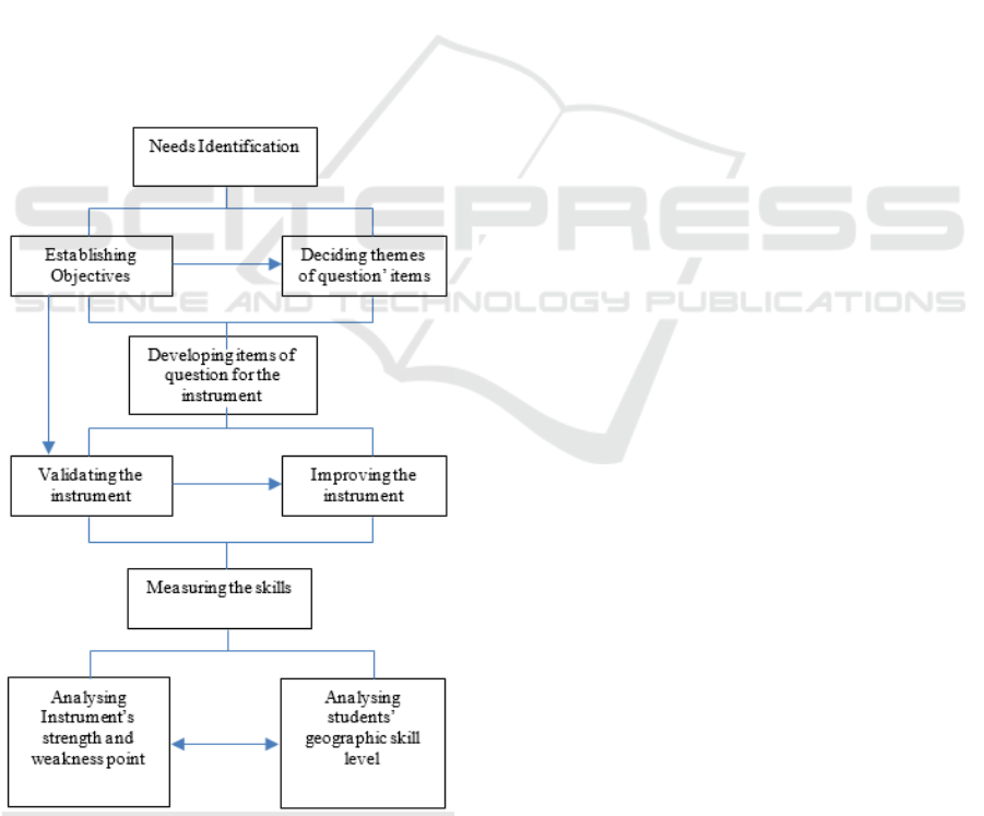
This research was done through a relatively easy
process, began with needs identification as the basis
for establishing the objectives of measuring
geographic skills. Deciding several themes as
reference in the development of the question items,
developing item of questions as the research
instrument, testing validation of the instrument, and
improving the instrument. After the geographic skills
measuring was done, the final stage was to analyze
the strength and weakness of the instrument and the
geographic skill level of the students.
Figure 1: Research Process.
4 FINDINGS AND DISCUSSIONS
4.1 Developing Instrument to Measure
Geographic Skills
Geography students are prospective geography high
school teachers who are required to have geography
skills. The demands are quite rational because they
will develop geographic skills of their students.
The first step to measuring geography skills is to
develop standard instruments that start from the
identification of needs, goal setting, question’s
themes development, question items development,
instrument validation, instrument improvement,
measurement implementation, and measurement
analysis.
Questionnaire to measure geographic skills is in
multiple choice form by selecting three subjects that
are related to spatial abilities, geo-literacy, and global
view. Spatial ability components are developed
including themes of cognitive maps, cognitive
collage, and spatial mental, while geo-literacy
components include interactions and
interconnections. For the global view components
consist of the effects of globalization in the field of
socio-cultural, understanding climate change, global
disaster, and competitiveness of Human Resources.
Here are the themes for the questions:
Cognitive Map
Define routes to known locations;
Specify routes to unknown locations;
Determine the shortest route between two
locations;
Determine the shortest route between more
than two locations.
Cognitive Collage
Matches the image to the appropriate location;
Convert verbal information into images and
vice versa.
Spatial mental
Simulate object changes in space;
Predict the movement of the object;
Determine the relationship between one object
with another object in space.
Interactions
Determine the location / object / event that
affect each other based on certain
characteristics;
Find evidence of locations, objects, or events
that affect each other based on certain
characteristics.
ICES 2017 - 1st International Conference on Educational Sciences
356
Interconnections
Determine the relationship between locations,
objects, events based on certain characteristics;
Describe relationships between locations,
objects, events based on location patterns.
Implications
Predict the impact of interaction and
interconnection between locations, objects,
events based on existing data;
Formulate effective measures to reduce the risk
of negative impacts of interaction and
interconnection;
Formulate effective steps to achieve a positive
impact of interaction and interconnection.
Global view
Effect of globalization in the socio-cultural
field;
Understanding climate change;
Global disaster;
The competitiveness of Human Resources.
Here is an example of question to measure
geographic skill:
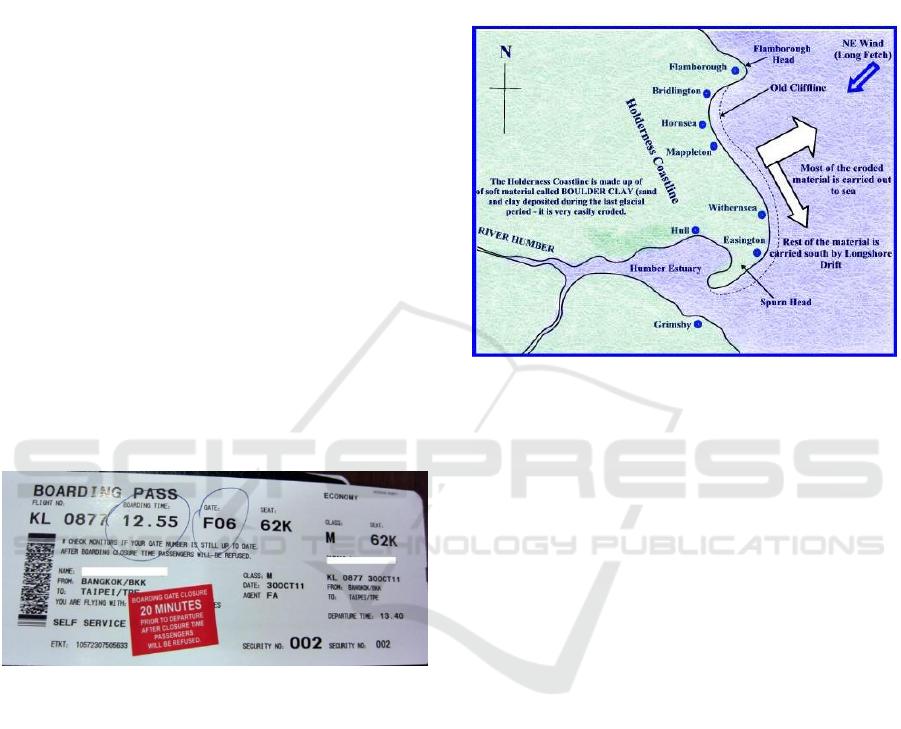
4.1.1 Example of Cognitive Map Question
Look at the boarding pass below!
Figure 2: Example of Cognitive Map Question.
If the North has azimuth map 0
o
, then the airplane
boarded by the owner of this boarding pass move in
the direction of azimuth ....
A. 0
o
B. 45
o
C. 90
o
D. 225
o
E. 315
o
The above questions are example of mental map
measurement., it is necessary to know about the
location of the plane take off (Bangkok) and the plane
will be landing (Taipei – Taiwan) to answer the above
question. The key answer to the above question is B.
The students who do not know the location of
Bangkok and Taipei will certainly fail to answer the
above question. In addition, knowledge of the
orientation of maps is also required, i.e. knowledge of
azimuth concept maps.
4.1.2 An Example of Cognitive Collage
Question
Look at the picture below!
Figure 3: An example of cognitive collage question.
If the above map shows the river estuary and spit,
then it can be expected that ...
A. Sea sedimentation is higher than abrasion
B. Potential delta formation at the mouth of the river
C. The formation of bay, cape and keo
D. The rainfall is longer than drought
E. Flood can extend to 20 meters
The above question has a goal to measure the
ability of students in turning image information into
verbal information. In geographic term it is called the
ability of map interpretation which is one of the
geography skills.
4.1.3 Example of Spatial Mental
The spatial mental question is a question for
measuring the ability to understand and apply the
knowledge of the map to a particular context. Here is
one example of a spatial mental question
Which map symbol is generally far apart from other
symbol on a map?
A. Symbol of grave and school
B. Symbol of mosque and market
C. Symbol of settlement and postal service
D. Symbol of the hospital and historic place
E. Symbol of the head of villagers office and historic
place
Geographic Skills Measurement for Geography Education Students
357

The above question has degree of C4 (application)
that is applying location theory in reading or
interpretation of land use map. This capability is
universal because land use patterns follow a common
pattern of land benefits. In the case above, the
location of the school must meet the requirement that
it should not be adjacent to the crowds of markets,
terminals, and or the burial site. Thus, the location of
schools and cemetery sites are generally far apart so
that the symbol of the map between the burial site will
be far from the school location.
4.1.4 Example of Interaction and
Interconnection Question
Another example is to measure students' predictive
ability from the impact of interaction and
interconnection between locations, objects, events
based on data:
Look at to the below Garuda Indonesia Airlines
service routes!
Figure 4: Example of interaction and interconnection
question.
In development context, this map can be used to view
phenomenon of ...
A. Flight activity
B. Intensity of population mobility
C. Center of regional growth
D. Garuda Indonesia Airlines promotion
E. Flight information for passengers
The above question has the advantage to measure
the ability of the students’ association skill to
associate the intensity of interaction with the growth
of the region.
4.1.5 Example of Implication Question
In the upper river there has been forest destruction.
Below is the case that will appear at the end...
A. Erosion and flash flood
B. Landslides and river silting
C. Springs and forests destruction
D. Agricultural production decreasing
E. Urbanization and unemployment
This question has the advantage of measuring the
ability to predict a geographical condition in the
future.
To answer the above questions logical thinking
range is existing (Yani, 2016). The answers are all
correct, but the spatial phenomenon arise at the end
due to forest destruction are urbanization and
unemployment. The logical thinking range is
"distance" between two concepts connected by the
unseen concepts when the two concepts are
connected. As in the example above, the nearest
distance between the forest destruction in the upper
river is erosion and flash flood. After the flood
disaster, the next impact is springs and forests
destruction. It will be followed by a decline in
agricultural production that causes poverty in the
village. Furthermore, the poverty will encourage
people to urbanize because of the many are
unemployed. To explain the relationship between the
forest destruction with urbanization need several
logical reasons. Thus comes the term of logical
thinking range.
4.1.6 Example of Global View Question
Each living environment has an ecological carrying
capacity limit. The situation in the urban environment
that has exceeded the carrying capacity is:
A. Often experience water shortages and flooding
B. Hit by a devastating earthquake and tsunami
C. The atmosphere is stuffy, densely populated, and
often jammed
D. Lots of garbage and river water are polluted
E. Is often plagued by infectious diseases
The above question can measure students' insights
about the symptoms of environmental threats caused
by common human behavior in any place that is
subjected to population pressure.
The above examples are way of how researchers
develop questions of the instrument to measure
geographic skills.
4.2 Developing Instrument to Measure
Geographic Skills
The questions form for measuring geographic skills is
multiple choice, distributed in 30 items of questions
with the following divisions:
Spatial ability = 11 items;
Geo-literacy = 12 items;
Global view = 7 items.
The subjects of the study were college students of
Department of Geography Education, FPIPS
ICES 2017 - 1st International Conference on Educational Sciences
358

Universitas Pendidikan Indonesia with the number of
participants of 70 students. Here are the results:
Highest score = 21;
Lowest score = 7;
Mean = 13,44 (44,8%);
Median = 3,10;
XYCorrelation = 0,34;
Reliability = 0,51;
Distinguishing power = 25,26.
Difficulty Level:
Very difficult = 1 piece;
Difficult = 7 piece;
Medium = 19 piece;
Easy = 3 piece.
Significance of Question item score to total score:
Very significant = 1 piece;
Significant = 2 piece;
Not significant = 27 piece.
Based on the above data, the average score
obtained by the research subjects was 13.44 or 44.8%
which means below 50% (expected average). In fact,
if considering the difficulty level there are 19 (63.3%)
questions are easy. The distinguishing power of 25.26
is relatively moderate. This data indicates that the
developed instrument is suspected problematic.
Tuckman cited by Purwanto (2011) explain that a
measuring instrument must qualify as a good
measure, at least have adequate validity and
reliability. A valid instrument is capable of measuring
object to be measured precisely. "Validity of a test has
been defined as the extent to which the test measures
what it was designed to measure" (Aiken, 1994: 103).
While reliability is the consistency of measurements
required to obtain valid results. However, there are
times when instruments are questioned about its
invalid reliability, because validity is related to the
feasibility of the interpretation of the test results,
while the reliability is related to the consistency of
test results.
Referring to the results above, the competence of
research subjects who only get a score of 13.44
(44.8%) can be said have low competence. Other
facts also indicate that the problem presented actually
has good distinguishing power with a relatively easy
level of difficulty.
However, it should also be recognized that the
developed questions appear to be invalid because 27
of the 30 items are stated to have questions item to
total score correlation is insignificant. To ensure the
validity of the questions, it appears that it should
enlarge the number of research subjects (Sugiyono,
2010) and need to select subjects randomly to ensure
the election of representative sample.
5 CONCLUSIONS
The result of the test instruments development for
measuring geographic skills in this research seems
less satisfactory. Although the reliability of the
questions is good (0,51) but it does not have high
score of validity. Question items are not able to
measure the object to be measured, therefore
additional research subjects to determine the level of
validity are required. However, to increase the
number of research subjects, it should also look for
more diverse sample candidates and randomly
selected. In this research it is admitted that the
research samples are not random because they are
only from one community which are the Geography
Education Students class of 2016. For the benefit of
further research, it is recommended to choose other
more senior students, or even graduate students either
master or doctoral degrees. Although the validity of
this prediction is not satisfactory, but researchers
hope that the content validity and construct validity
can be rationally accountable and likely to continue
to be developed. The development of geography
skills measurement instrument will change much of
the perception of geography. The former geography
subjects are only considered as general knowledge
taught in school and are less meaningful, after which
research will enrich the society's insight that
geography subjects can be beneficial to the lives of
learners in the future. Thus, this research is very
useful to establish geography subjects in the
Curriculum 2013 in Indonesia.
ACKNOWLEDGEMENTS
This research was funded by the Graduate School of
Universitas Pendidikan Indonesia. Therefore, the
researchers would like to thank the Rector of
Universitas Pendidikan Indonesia and the Director of
Graduate School of Universitas Pendidikan
Indonesia.
REFERENCES
Aiken, L. R., 1994. Psychological Testing and Assessment,
Allyn and Bacon, Inc. Boston.
By, R. A. D., 2001. Principles of Geographic Information
Systems (An introductory textbook), The International
Institute for Aerospace Survey and Earth Sciences
(ICT). Netherlands.
Geographic Skills Measurement for Geography Education Students
359

Lohman, D. F., 1988. Spatial abilities as traits, processes,
and knowledge, Lawrence Erlbaum Associates.
Hillsdale,
4th
edition.
May, T. C., Smith, P., 1998. Spatial Ability: A Handbook
for Teachers. National Foundation for Educational
Research, The Mere, Upton Park, Slough, Berkshire
SL1 2 DQ.
National Geography Society 2009. What is Geo-literacy?
Learn About a Concept That is Critical for Society's
Future, Available on https://www.nationalgeog-
raphic.org/media/what-is-geo-literacy/.
Purwanto, N., 2011. Evaluasi Hasil Belajar, Pustaka
Pelajar. Yogyakarta.
Sugiyono, 2010. Metode Penelitian Pendidikan
Pendekatan Kuantitatif, kualitatif, dan R&D, Alfabeta.
Bandung.
Yani, A. 2016. The Development of Diagnostic Test for
Measuring Students’ Logical Thinking Range: A Study
of Geography Subject. IJCTA. 9(28), 2016, pp. 01-18.
International Science Pres.
ICES 2017 - 1st International Conference on Educational Sciences
360
