
Integrated System for Collecting and Reporting
Crash and Citation Data
Alexander Paz, Cristian Arteaga and Carlos Gaviria
Howard R. Hughes College of Engineering, University of Nevada, Las Vegas, 4505 Maryland Parkway, PO Box 454007,
Las Vegas, U.S.A.
Keywords: Crash Data Collection, Citations Data Collection, Geographic Information System, Mobile Data Collection.
Abstract: Currently, the collection of crash and citation data is performed by law enforcement agents without taking
full advantage of existing state-of-the-art technologies. Availability of communication networks and recent
developments in software technology provide opportunities to collect data in an easier, faster, and more
accurate manner. Key challenges in collecting of this type of data include standardizing and capturing the
right location where crashes occur as well as minimizing the exposure time of law enforcement agents at the
scene. This paper describes the development of a state-of-the-art crash and citation data collection system and
geospatial database, hosted by a remote server, a mobile application, and a web portal. The proposed system
takes full advantage of Geographic Information and Positioning Systems to capture location data and provide
tools to create scene diagrams. The proposed system was designed and implemented in cooperation with law
enforcement agencies and data users to meet the needs of various stakeholders.
1 INTRODUCTION
Some of the existing software and hardware used by
law enforcement agencies to collect crash data are
obsolete for several reasons, ranging from budget
constraints to lack of coordination across various
groups. The most significant consequence of using
obsolete tools are location errors, which preclude the
correct use and reliability of the data. In addition, the
time required for law enforcement agents to be at the
scene could be lengthy, especially to collect data
adequately.
Accurately locating crashes is key to geographic
analyses of crash statistics and patterns as well as for
the development of safety recommendations for crash
‘hotspots’. Generally, an involved process is required
to locate crashes and collect relevant data on public
roads, using text formats and hand drawings. Many
crashes cannot be located or have been incorrectly
located, and the data are hard to register. The main
impediments to locate crashes accurately and collect
crash data are well known, and include errors in data
entry, street name errors by the recording officer, the
existence of alias names, and county coding errors as
well as many other factors.
Crash data can be analyzed to study the incidence
of the various factors in crashes; for example,
information of events involving drivers under the
influence of alcohol (DUI) can be used to support
decision making. The methodologies for traffic safety
management recommended by the Highway Safety
Manual (AASHTO, 2010) require accurate crash and
location data (Paz et al., 2015), currently collected by
law enforcement agencies. This data are needed for
performance-based traffic safety programs as well,
and must be prepared by state agencies to address
requirements from the legislators (NCHRP, 2010;
FHWA, 2013).
To address data-collection issues and provide
better technology for law enforcement agents, the
Transportation Research Center (TRC) at the
University of Nevada, Las Vegas (UNLV), has
developed and implemented a system for the accurate
and efficient collection of crash data, including
location. The proposed solution uses a Geographic
Positioning System (GPS) and a Geographic
Information System (GIS) to geolocate crashes and
provide a map-based data-collection environment.
Compared to existing processes and technology in
use, this system greatly reduces the time and
resources involved in consistency checking and error
correcting during data collection.
Paz, A., Arteaga, C. and Gaviria, C.
Integrated System for Collecting and Reporting Crash and Citation Data.
DOI: 10.5220/0006648202250230
In Proceedings of the 4th International Conference on Vehicle Technology and Intelligent Transport Systems (VEHITS 2018), pages 225-230
ISBN: 978-989-758-293-6
Copyright
c
2019 by SCITEPRESS – Science and Technology Publications, Lda. All rights reserved
225
The proposed system was developed with help
from various law enforcement agencies in Nevada.
Considering the challenges associated with collecting
location information as well as the data need of
various stakeholders, in addition to the geospatial
coordinates of the crash, the proposed system
includes a scene diagram that captures screenshot of
the crash location, using a GIS map.
The development, implementation, and testing of
the proposed system included continuous interaction
between users and developers in order to take full
advantage of field experience and associated needs
(Racheva and Daneva, 2010). This ensured that the
expectations and needs from law enforcement
agencies and data users were fully addressed.
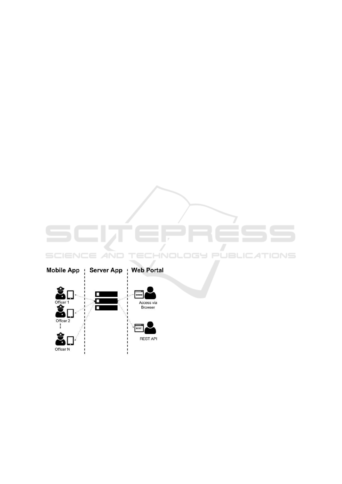
2 PROPOSED SYSTEM
The system involved a server hosting a geospatial
database, a mobile application, and a web portal, as
shown in Figure 1. Law enforcement agents collect
crash and citations data using the mobile application.
The data are send in real time to the geospatial
database hosted by the server application, which
makes the data available through the web portal. In
addition to a website, the web portal offers a REST-
API (Fielding, 2000) web-service endpoint, which
allows external systems to extract raw or aggregated
information. This web service endpoint was built
using Open Data Protocol (OData, 2010).
Figure 1: Conceptual illustration of the proposed system.
The primary requirements of the proposed
solution include:
1. Accuracy of the location information;
2. Efficiency to minimize the time required by the
agent to be in the field;
3. Flexibility to navigate through menus;
4. Synchronization across crash and citation data,
when required;
5. Capabilities to create a scene diagram, powered
either by a map or using a freehand sketch view;
6. Capabilities to attach to reports all types of files,
including pictures, and a screenshot of the crash
location;
7. Capabilities to read information from driver
licenses and vehicle registrations by using a
barcode reader, and
8. Querying capabilities through the web portal to
generate graphs, charts, and reports.
In addition, it is desirable that a data collection system
considers real time statistics, ease of access to the
data, data completeness, and safety of the data
collector, among other primary issues. A description
of how the proposed solution addresses these issues
is provided in this paper.
The proposed system will be tested by law
enforcement agencies in Nevada. Therefore, the
system was implemented in compliance with the
standard data dictionary for crash and citations
information for the State of Nevada Citations and
Accident Tracking System (NCATS) (NHTSA,
2010).
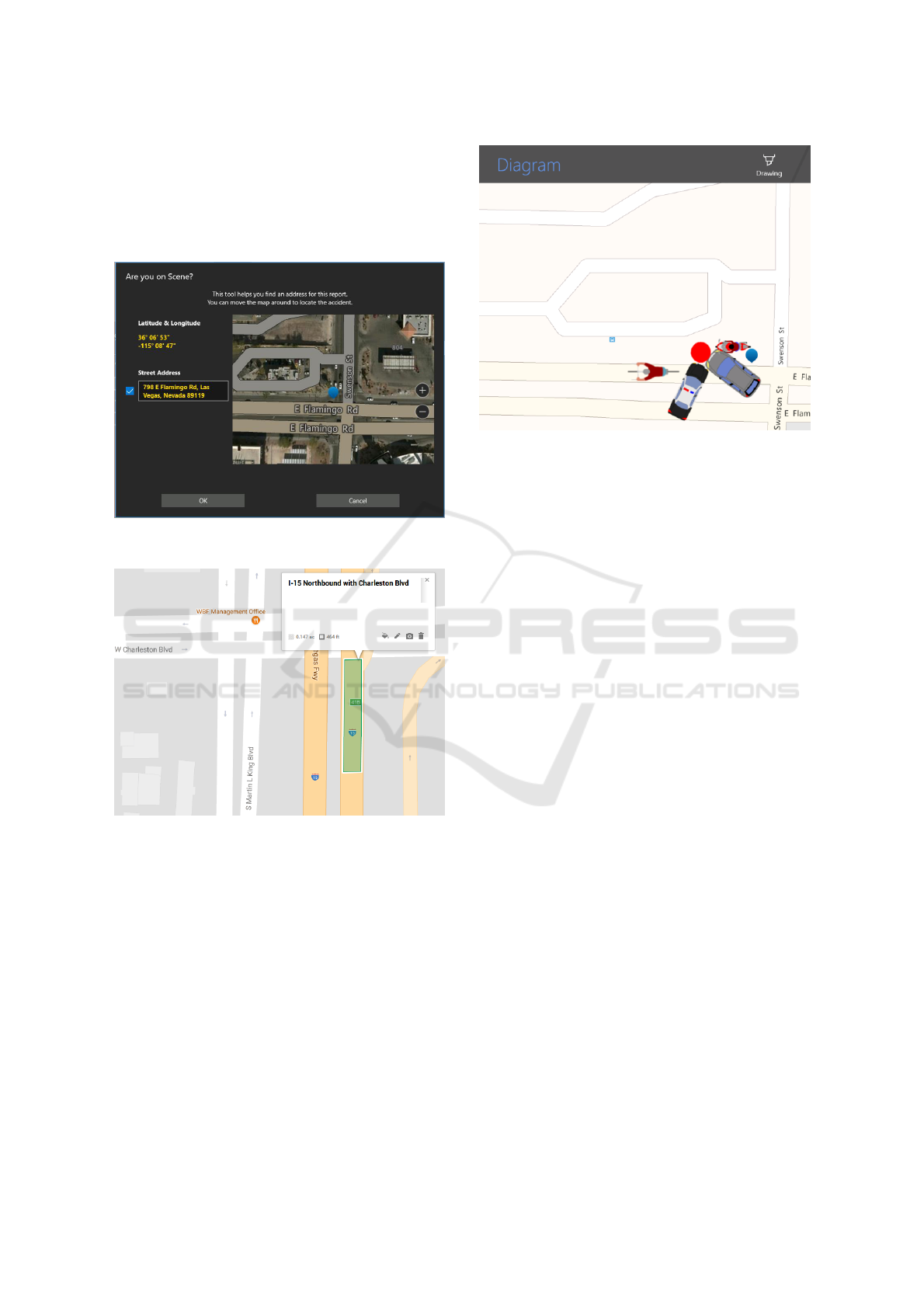
2.1 Data Accuracy
Although all collected data are important, currently,
the most challenging issues focus on location and
scene information. Current data collection solutions
used by law enforcement agencies, require typing the
location of the crash or citation. Those locations can
be translated into coordinates and geographical
information. However, frequent entry errors preclude
the correct translation. The proposed system allows
on-site location capture using GPS and maps. Figure
2 illustrates the user interface that allows location
capture. The coordinates and corresponding address,
if existing, for a crash or citation is provided by GPS
and displayed on the screen. If the accuracy of the
GPS is not sufficient or the data collection device is
located away from the crash location, the agent can
use the touch-screen map to set the correct location.
An additional challenge for locations on highways
is when a location does not have a physical or mailing
address. In these cases, police officers assume a
reference point (for example, an intersection or ramp)
and guess a distance to such a reference point.
However, guessing is subjective, and generates
accuracy issues and inconsistency in the stored data.
To address this challenge, the proposed system allows
the administrator to partition the highways into small
regions, each with a unique geo-tag or standard
VEHITS 2018 - 4th International Conference on Vehicle Technology and Intelligent Transport Systems
226
location label. This partitioning enables consistent
location information and accuracy. Figure 3
illustrates this geo-tagging functionality. Using this
capability, a police officer collecting data just needs
to check that the software has selected the right geo-
tag or geographical region.
Figure 2: Capture of crash and citation location by the
proposed system.
Figure 3: Definition of labeled areas for location on
highways.
Figure 4 illustrates the user interface that enables
the construction of a crash scene diagram. This
interface shows, by default, the GPS location of the
mobile device hosting the mobile app. In order create
a realistic and detailed representation of crash, the
interface allows the agent to drag with his or her
finger all the elements involved in the crash scene. In
addition, the agent can create a freehand sketch of the
scene, and take an unlimited number of photos.
Figure 4: Crash scene diagram.
2.2 Real-Time Collection and
Reporting
The data collected are automatically sent to the server
in real-time on a regular basis by means of the cellular
network. This was designed to minimize the risk of
losing data because of a special event, such as the loss
or damage of the mobile device. If network
connection is not available, the data are stored in the
mobile device until the connection is reestablished
and the data are completely received by the server.
Once in the server, the data can be aggregated and
filtered in real time to generate reports. Among two
important applications. Figure 5 shows how the
system provides color-coded locations and the status
of crashes, based on how old they are, and/or an
applied filter. This type of information could be
important for real-time operations and tactical
decisions by managers and supervisors. Figure 6
illustrates how a heat map is used that allows the user
to zoom into specific zones and apply filters to
analyze crash patterns in detail.
Figure 7 illustrates the density of crashes by day
of the week and time of the day for a selected year.
By default, this summary includes the entire number
of crashes in the system but it can be filtered by the
severity of the crash (injuries, fatalities, property
damage). Other available filters and diagrams include
severity of crashes, involvement of drugs, and gender
or age.
Integrated System for Collecting and Reporting Crash and Citation Data
227
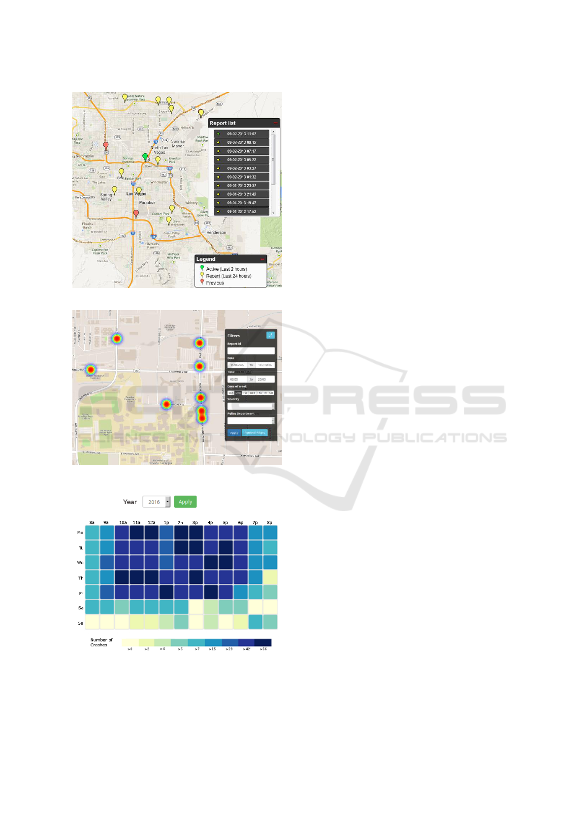
Figure 5: Crash location and status.
Figure 6: Heat map of crash densities.
Figure 7: Crash density by day of week and time of the day.
2.3 Ease Access to Data
The data collected are available online and can be
accessed easily through the web portal or the REST-
API. For the web portal, an account is required to
register, modify, or aggregate the data. A reporting
feature has been included in the proposed system to
allow exporting aggregated or disaggregated reports
in 1) common formats for data interchange, such as
XML, CSV, and JSON; and (ii) common document
formats, such as PDF, DOC and XLS. If desired,
some of this information can be made available for
public access, including special statistics.
If required by government agencies or
interconnected systems, this proposed system offers a
REST-API with OData protocol implementation. The
use of an OData implementation makes information
retrieval of linked entities easier (Carey, 2012). The
access to the REST-API is available only for
authenticated users.
2.4 Data Completeness
Law enforcement agencies have requirements
concerning the collected information. Data
dictionaries are designed to standardize the structure
and codification of the information. For illustration
purposes, the proposed solution for this system
implements all the required fields that are specified in
the NCATS data dictionary, version 2010.
Implementations using a different data dictionary
requires changes to the system, which could be minor
or large, depending on the differences with NCATS.
However, all important and significant capabilities,
such as the collection of location information and
scene diagram, require no changes to the system
unless special needs or upgrades are demanded.
In order to minimize the risk of mistyped
information, and reduce the effort required to
manually type in the data, such features as barcode
readers for driver license and vehicle registrations
were implemented in this proposed system.
2.5 Safety of the Agent
It is very important to minimize the time that the
agents are exposed to traffic and danger. The
proposed system was designed to minimize the time
required by an agent to collect field data. In critical or
urgent situations, an agent can collect on-site critical
information rapidly by using a minimum number of
touches to the screen on the GPS device, the camera,
and the barcode reader. Later, when in a less risky
environment, the agent can complete the rest of the
VEHITS 2018 - 4th International Conference on Vehicle Technology and Intelligent Transport Systems
228

data collection by using the mobile application or the
web portal.
Table 1 shows an estimated time to collect critical
information about a typical crash scenario with two
cars and two occupants. This estimation assumes that
the agent has access to the drivers’ licenses and
vehicle registrations.
Table 1: Estimate time to collect critical crash data.
Information
Item
Time
(sec)
Location
5
Vehicles
12
Drivers
12
Pictures
10
Total
39
3 RESULTS
Multiple meetings with law enforcement agencies in
the State of Nevada have been conducted to review
the design and implementation of the proposed
system. Law enforcement agents have acknowledged
that the mobile application provides enough accuracy
to capture location information. They agreed that the
crash-scene diagram tool provides all the necessary
elements to create a reliable representation of the
scene. In addition, they have suggested usability
improvements, such as pre-filled values and favorite
lists for commonly used fields.
Administrative staff has validated compliance of
the collected information with the NCATS data
dictionary. It has been confirmed that the reports and
statistics generated in the web portal contain the
required information. Additional statistics and reports
have been suggested by administrative staff to
increase the benefits of the reporting tool. Feedback
has been collected from multiple agencies, and new
features have been added to the proposed solution
based on their suggestions.
To validate the proposed system in a real-life
environment, a field test was completed with the
Nevada Highway Patrol (NHP) Southern Command.
The field test was designed to collect feedback from
four police officers having distinct roles in the data
collection process. One agent was the system
manager, and had a high-level knowledge of the
technical features of the system. The other three
agents were troopers who collected daily information
on crashes and citations on the highways. Two of
them collected information using a tablet device and
the other with a handheld device. The requirement
was that all four police officers collected at least three
crash reports and three citations. In total, 12 crash
reports and 15 citations were collected.
Results from the field test were used to improve
the system. Several enhancements related to usability
were implemented. The field test participants
highlighted the (i) significant reduction in time
required for data collection and (ii) ease of interaction
with the system.
4 CONCLUSIONS
The developed system is able to collect crash data in
situ and store it in a geodatabase. Data that is
collected is characterized and processed in real-time
to generate reports, maps, charts, and statistics. The
proposed data collection system facilitates the data
collection while saving time, reducing errors, and
enabling the collection of the more valuable
information from crashes, such as the scene diagram.
The proposed system is the result of a combine effort
involving law enforcement agencies, the Nevada
Department of Transportation, and the University of
Nevada, Las Vegas.
Future work includes the development of
additional performance measures. A key capability
required by law enforcement is the ability of multiple
officers to be able to work on the same report at the
same time. In addition, such capabilities as the ability
to generate collision diagrams and visuals are
desirable that can report various statistics, including
expected crash frequencies and the rankings of sites
based on them (Paz et al., 2014). The field test
provided a great opportunity for NHP to propose
valuable capabilities, such as:
Geo-tagging or highway regions to improve
location accuracy.
A tool to compute the distance from a crash
location to a reference point defined by the
agents.
Towing sheets to register and print
information of vehicles that were towed
after a crash or citation.
Social media notifications for crashes
classified as severe.
These are very desirable features that were
devised only because of suggestions and ideas
generated during the field test. These capabilities are
currently under development for planned field testing.
Integrated System for Collecting and Reporting Crash and Citation Data
229

ACKNOWLEDGMENTS
This study was sponsored by the Nevada Department
of Transportation and the Federal Highway
Administration. Special thanks to Major Thom
Jackson and Trooper Nicholas O'Conner from the
Nevada Highway Patrol for their guidance and
recommendations. Similarly, many thanks to
Lieutenant Brandon Brooks from the Henderson
Police Department and Lieutenant Leonard Marshall
from the Las Vegas Metropolitan Police Department
for their support and provided information. Many
thanks to the Technical Writer of UNLV’s Howard R.
Hughes College of Engineering, Julie Longo, for
editing this manuscript.
REFERENCES
Carey, M.J., Onose, N. and Petropoulos, M., 2012. Data
services. Communications of the ACM, 55(6), pp.86-
97.
Fielding, R.T., 2000. Architectural styles and the design of
network-based software architectures (Doctoral
dissertation, University of California, Irvine).
Manual, H.S., 2010. American association of state highway
and transportation officials (AASHTO). Washington,
DC, 10.
National Cooperative Highway Research Program,
Cambridge Systematics, American Association of State
Highway and Transportation Officials, 2010. Target-
setting Methods and Data Management to Support
Performance-based Resource Allocation by
Transportation Agencies (Vol. 666). Transportation
Research Board.
Nevada Highway Traffic Safety Administration.
(2010). Nevada NCATS Data Dictionary. [online]
Available at:
http://www.nhtsa.gov/nhtsa/stateCatalog/states/nv/nev
ada.html [Accessed 23 Nov. 2016].
National Highway Traffic Safety Administration.
(2010). Nevada NCATS Data Dictionary. [online]
Available at:
http://www.nhtsa.gov/nhtsa/stateCatalog/states/nv/nev
ada.html [Accessed 23 Nov. 2016].
Odata. (2015). OData - the Best Way to REST. [online]
Available at: http://www.odata.org [Accessed 23 Nov.
2016].
Paz, A., Veeramisti, N., Khanal, I., Baker, J. and de la
Fuente-Mella, H., 2015. Development of a
comprehensive database system for Safety Analyst. The
Scientific World Journal, 2015.
Paz, A., Khanal, I., Veeramisti, N., Baker, J. and Belmonte,
L. 2014. Development of a Visualization System for
Safety Analyst. Transportation Research Record. No.
2460, 175–184. doi:10.3141/2460-19.
Racheva, Z. and Daneva, M., 2010. Clients’ participation in
software projects: comparative case study between an
agile and a ‘traditional’ software company. first
Workshop on Leveraging Empirical Research Results
for Software Business Success.
VEHITS 2018 - 4th International Conference on Vehicle Technology and Intelligent Transport Systems
230
