
Citizen Participation in Urban Planning-Management Processes
Assessing Urban Accessibility in Smart Cities
Raquel Pérez-delHoyo
1
, María Dolores Andújar-Montoya
1
,
Higinio Mora
2
and Virgilio Gilart-Iglesias
3
1
Department of Building Sciences and Urbanism, University of Alicante, 03690 Alicante, Spain
2
Specialized Processor Architecture-Laboratory, Department of Computer Science Technology and Computation,
University of Alicante, 03690 Alicante, Spain
3
Department of Computer Science Technology and Computation, University of Alicante, 03690 Alicante, Spain
Keywords: Inclusive City, Citizen Participation, Cloud System, Sensing Technologies, Smart City, Social Inclusion,
Sustainable City, Technology-Aided Urban Design, Urban Accessibility.
Abstract: The concept of Smart City, supported by the latest technological advances in the field of Information and
Communication Technology, offers great potential to meet the challenges of cities in the economic
globalization context. As a consequence, the present work is focused on the deployment of these
technologies through public participation activities to generate knowledge for the processes of urban
planning, design and management.The methodology proposed in this work allows obtaining information
about accessibility problems directly from citizens, based on their own experience. Citizens have a
communication channel that allows them to inform, at any time and in any place, about all the accessibility
problems they encounter when they move around a city in their daily activity. The work presents a Case
Study focused on a experience of citizen participation which has been developed to evaluate the
accessibility of urban environments in Benalúa neighbourhood of Alicante in Spain. A diverse group of
neighbors of different ages, gender and abilities have participated in the experience. After the
experimentation it was concluded that the research offers new forms of communication to facilitate
information flows between the Administration and citizens, allowing their integration and feedback.
1 INTRODUCTION
In the current context of economic globalization,
cities must assume new roles and a greater
responsibility by adopting new policies and
strategies (Martinez-Fernandez et al., 2012). Cities
are the entities with the greatest capacity to innovate
and operate in increasingly open and competitive
environments. In this sense, the concept of Smart
City —hereinafter SC—, supported by the latest
technological advances in the field of Information
and Communication Technology —hereinafter
ICT—, offers great potential to meet the challenges
of cities in this new global context.
People are the main resource that cities have in
order to create competitive advantage (Florida,
2005; Cossetta and Palumbo, 2014). In recent years
it has been estimated that participation has been
growing significantly in all public spheres. There is
a worldwide consensus on the need and benefits
about incorporating citizens into public
management. Therefore, the design of cities of the
future represents a collective challenge today, which
not only involves governments but also includes
citizens. Therefore, the concept of public
participation must be now understood as integrated
into the normal functioning of societies, as part of
everyday urban processes and dynamics. In this
regard, the use of ICT and their integration into the
functioning of the city is essential. It is a fact that
changes and technological advances are leading to a
new model of society that is increasingly informed,
with greater citizen awareness and predisposed to
participation (Castells, 2011).
At present, new technologies of computing,
sensing and telecommunications provide knowledge
and intelligence to the city (Gabrys, 2014) and play
an important role in many aspects of their daily
management (Neirotti et al., 2014; Angelidou,
2015). The deployment of these technologies in the
context of SC to generate knowledge for the
206
Pérez-delHoyo, R., Andújar-Montoya, M., Mora, H. and Gilart-Iglesias, V.
Citizen Participation in Urban Planning-Management Processes.
DOI: 10.5220/0006704202060213
In Proceedings of the 7th International Conference on Smart Cities and Green ICT Systems (SMARTGREENS 2018), pages 206-213
ISBN: 978-989-758-292-9
Copyright
c
2019 by SCITEPRESS – Science and Technology Publications, Lda. All r ights reserved

processes of urban planning, design and
management based on public participation activities
is the object of this work.
The improvement of the quality of life is one of
the most recurrent and demanded urban issues. One
of the most important aspects that influence the
quality of urban life is the inclusion of all citizens.
Therefore, cities require an inclusive urban life
(Colantonio and Dixon, 2011) and in order to
achieve this, they need to be accessible (Steinfeld
and Maisel, 2012). Accessibility is a quality of life
element with universal interest, and a right of all
citizens (United Nations, 2006). Difficulties of
accessibility, deterioration of the built environment,
or difficulty of social relations, are some of the
problems that directly affect the quality of urban life.
In this context, this research studies the capture
of urban accessibility diagnoses from public
participation processes through the use of the latest
ICT, with the objective of generating knowledge for
the planning, design and management
—maintenance— of accessible cities. The rest of the
work is organized as follows: Section 2 explains the
motivation and objectives of the work. Section 3
gives an overview of the work related to assessing
the accessibility of urban environments. Section 4
describes the proposed methodology. Section 5
explains the experience developed in an urban
environment as a Case study from which a diagnosis
of accessibility has been obtained. Finally, Section 6
shows some conclusions of the paper.
2 MOTIVATION AND
OBJECTIVES
Today there is consensus on the advantages and
benefits of citizen participation in urban decision-
making. In this regard, regulations have even been
developed. The city is the entity where the space of
participation acquires greater importance. However,
in most cases citizens do not achieve to be an active
part of urban planning, design and management
processes. Therefore it is necessary to have an
impact on opportunities in order to achieve effective
citizen participation and promote actions that are
based on citizen participation.
It is demonstrated that new ICT offer great
potential to meet the challenge about how citizens
can participate in the construction of the city. All
cities want to be SC and deploy these technologies
to improve many aspects of their daily management.
However, they do not have enough simple and
economically viable technological proposals. In this
sense, the aim of this research is to offer effective
methods for citizen participation using the latest
technological advances in the field of ICT that can
actually be implemented in medium-size cities
—cities with urban centre sizes in population
between 100 000 and 250 000— (Dijkstra and
Poelman, 2012). Therefore, our main goal is to
research for really smart and inclusive cities through
the implementation of sustainable technological
methods, without excessive cost and respectful with
the environment.
Inclusive design promotes the creation of
accessible spaces open to all citizens. But the
concept of inclusive city refers not only to
facilitating the use of these spaces but also to
involve the citizens in their conception, development
and maintenance (Fletcher, 2006). This means that
all the agents involved: planners, designers, users
and managers, must participate in the processes of
planning, design and maintenance of the city. The
inclusive city is therefore a responsibility of all, and
tools are necessary to make possible communication
between all agents.
The purpose of this research is to make way in
this direction, proposing new channels of open
communication. Inclusion and citizen participation
to improve the quality of life (Arnstein, 1969) is an
aspiration of most European countries. In this
context, this paper aims to promote —in the context
of the SC and with the use of the latest ICT— the
active participation of citizens in the processes of
improving urban accessibility in order to achieve the
inclusion of all citizens, and their identification with
the urban environment.
This proposal is part of the objectives of the
European Disability Strategy 2010-2020: A
Renewed Commitment to a Barrier-Free Europe
(European Commission, 2010a), developed in the
framework of the strategy Europe 2020: A Strategy
for smart, sustainable and inclusive growth
(European Commission, 2010b).
3 BACKGROUND:
TECHNOLOGY USED FOR
ASSESING URBAN
ACCESSIBILITY
Assessing the accessibility of urban environments
has been associated mainly with processes to inform
citizens about the number of urban opportunities
—available services, offer of activities, commerce—
Citizen Participation in Urban Planning-Management Processes
207

at a certain time and place. The accessibility of an
environment growth as the number of opportunities
that it offers increases, regardless of the capacities of
the citizens/users. These processes have been mainly
based on the calculation of proximity relations and
intensity of use, and have been mainly used by
technologies of Global Positioning Systems
—GPS— for positioning and Geographic
Information Systems —GIS— for the visualization
of the data and the spatial analysis. One of the
applications of greater impact has been the one of
planning of itineraries —travel times—. Most of the
proposals offer an application for users’ mobile
devices in order to interface and interact with the
system. From its origin, the main challenge of these
processes was to improve the individual assessment
of the accessibility of the environment, but with
improvements always focused on the average citizen
without disability (Kwan, 1998; Kwan and Weber,
2003, Kwan and Lee, 2004; Ford et al., 2015).
Progressively, the dimension of disability began
to be taken into account with the introduction of the
concepts of absolute and relative access, to measure
the differences in time in the performance of specific
routes or the impact of the removal of certain
obstacles (Church and Marston, 2003). The main
limitations of these technologies are related to the
differences of scale, acceptable in specific actions
but not effective for the urban scale.
Increasingly, the evaluation of the aspects that
affect the operation of the city is based on the
evidence, on the behaviour or movement of the
citizens (Gilart-Iglesias et al., 2015; Pérez-delHoyo
et al., 2017b), beyond street observation and audits
(Mackett et al., 2008), surveys or questionnaires
(Coppola and Papa, 2013; Beale et al., 2006),
interviews (Venter et al. 2002; Hashim et al., 2012)
or mathematical or statistical studies based on the
data obtained (Prasertsubpakij and Nitivattananon,
2012; Soltani and Allan, 2005). These participatory
evidence-based processes are undoubtedly a
challenging field of research for improving the
accessibility of the urban environment. Self-
reporting tools have allowed obtaining information
from certain places with the collaboration of citizens
(Shigeno et al., 2013). Other proposals use social
network communities to generate and complement
the information about accessibility issues in cities
(Menkens et al., 2011; Prandi et al. 2014). These
proposals also obtain information from the user by
means of self-reporting tools.
Cloud computing paradigm is one of the most
promising technologies to build new services for
users and enterprises (Targio et al. 2015; Marston,
2011). Mobile devices enable access to a wide range
of applications and services (Mora et al. 2015;
Makris et al., 2013). The proliferation of systems
and the high penetration rate of mobile devices in
the hands of citizens provide users an opportunity to
conduct a citizen-centric digital revolution in many
aspects of daily life.
4 METHOD
4.1 Characteristics of the Proposed
Methodology
The main objective of urban and territorial
development is the people who live in a certain
geographic space and, consequently, the degree of
success of the actions developed must be measured
in terms of the quality of life achieved, expressed in
terms of facilities, services, characteristics of the
environment, among other factors (Fernández,
2012). In this sense, the present work proposes a
methodology focused on people for the analysis and
diagnosis of the accessibility in urban environments.
That is, a method of citizen participation to assess
whether the characteristics of the urban
environment, the existing facilities and services, are
favourable and accessible to all citizens.
On the other hand, the concept of participation
implies that all the stakeholders that intervene in the
urban process can interact. It is not enough to keep
citizens informed, then new channels of open
communication are necessary (Fernández, 2012).
Therefore, the methodology proposed in this
research offers new forms of communication to
facilitate information flows between the
Administration and citizens, allowing their feedback.
In addition, the methodology allows systematic and
scalable participation.
4.2 Method Description
The method includes two parts that are described
below:
4.2.1 Method of Citizen Participation to
Evaluate the Accessibility of Urban
Environments —Capture of
Accessibility Information—
To assess the accessibility of urban environments it
is necessary to obtain information about the real
state of their characteristics. In addition, in order to
guarantee the maintenance of accessibility
SMARTGREENS 2018 - 7th International Conference on Smart Cities and Green ICT Systems
208
conditions, it is necessary to evaluate these urban
environments periodically.
In general, Administration safeguards that
accessibility standards are met when designing
urban spaces. There is a control by the
Administration so that the existing regulations are
fulfilled, before and after the execution of those
urban spaces. However Administration does not
have the resources to develop a periodic evaluation
of those spaces in order to keep their accessibility
settings in good condition. The development of a
process of citizen participation to assess the
accessibility of urban environments can undoubtedly
improve this situation, considering that are the
citizens who coexist daily with these accessibility
problems.
The methodology proposed in this work allows
obtaining information about accessibility problems
directly from citizens, based on their own
experience. Citizens have a communication channel
that allows them to inform, at any time and in any
place, about all the accessibility problems they
encounter when they move around city in their daily
activity. The method is conceived to integrate all
citizens in the participation regardless of their
abilities; it is not therefore a method directed
exclusively towards people with permanent or
temporary disability.
To collect data an Android application, “App”
has been designed. In this way, citizens have a
simple user interface for mobile devices that allows
them to report any accessibility problems they
encounter in the city. The idea behind this
functionality is that the accessibility issues are
notified at the same time they were detected by
users. The application reports the location of this
claim and a picture of it. The “App” for
Accessibility-Issues Self-Reporting Service has been
described in an own previous research conducted by
this research group (Mora et al., 2016). The
operation of the application is shown through a Case
study in Section 5.
4.2.2 Method for Managing Accessibility
Information by Administration
Having the real information about accessibility
problems in urban environments available, allows
the Administration to carry out a proper maintenance
of these public spaces in order to keep effective
accessibility. In addition, information flows are
produced systematically, so that accessibility
information is always kept up to date.
Administration can have the information
provided by citizens at their disposal through a Web-
Application for Accessibility Monitoring. The way
the information are organized and displayed is
shown in Section 5.
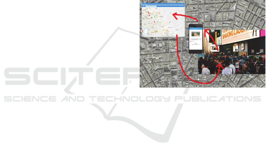
The method described in this paper (Figure 1) is
part of a comprehensive System for Monitoring
Urban Accessibility which consists of a distributed
architecture taking advantage of the new ICTs in a
context characterized by deployment of a wireless
communication infrastructure and the cloud
computing paradigm in SC environments. The
general overview of this System has been described
in an own recent previous research conducted by this
research group (Mora et al., 2017).
Figure 1: Citizen participation method proposed for
assessing urban accessibility in Smart Cities.
4.3 Diagnosis of Participatory
Accessibility
As part of this work, an experience of citizen
participation has been developed to evaluate the
accessibility of urban environments in Benalúa
neighbourhood of Alicante in Spain. A diverse
group of neighbours of different ages, gender and
abilities have participated in the experience. It was
proposed to take a route that, starting from the centre
of the neighbourhood, crossed the streets that led to
the main facilities and services. Citizens had to
identify the architectural barriers and accessibility
deficiencies that found during the proposed route.
All the participants had a mobile phone and could
install the “App” for Accessibility-Issues Self-
Reporting Service in a simple way. The experience
carried out is described in Section 5.
Citizen Participation in Urban Planning-Management Processes
209
5 CASE STUDY: BENALÚA
NEIGHBOURHOOD IN
ALICANTE
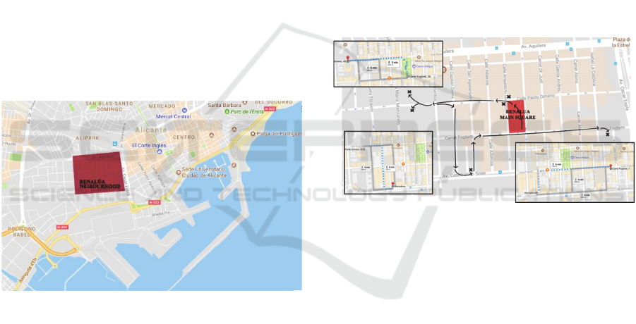
In this section we present the study that was carried
out in Benalúa neighbourhood in the city of Alicante
—Spain— (Figure 2). In order to determine the
degree of social inclusion, inaccessible points
between the different connections of the
neighbourhood were identified. The starting point of
the experimentation was the most representative
square of the neighbourhood —this square is located
in the centre of the neighbourhood and is the place
where the neighbours meet for any activity or
celebration—, and the routes from that square
towards the nearest places of services of the area.
The application developed has allowed us to map
the different points that prevent citizens with motor
disabilities from following the optimal and habitual
routes towards destination points, i.e. city
equipment. These barriers avoid the complete
integration of the resident citizen in the
neighbourhood of Benalúa.
Figure 2: Neighbourhood of study in the city of Alicante
—Spain—.
5.1 Research Scene
The neighbourhood of Benalúa is located
approximately one kilometre away from the historic
centre of Alicante. It is a residential neighbourhood
that belongs to the expansion district of the city,
built on the basis of a grid formed by blocks of
(100x40) meters and streets of 10 and 15 meters.
The neuralgic centre of the neighbourhood is a
square that occupies the extension of a block. In the
rest of the blocks, mostly residential, there are
facilities that serve not only Benalúa neighbourhood
but also the city of Alicante —Courthouses,
National Police, and Water Service, among others—.
Most of the residential buildings in the
neighbourhood were built in the 60s, 70s and 80s of
the last century, so it is not a new neighbourhood.
The neighbours are of very diverse incomes and
careers, and it is characterized for being quite
inclusive.
The reasons that give the neighbourhood a high
degree of quality, in relation to many others
consolidated in the city, derive directly from its
original planning that has allowed its operation in
order to adapt to new demands, while housing
important equipment for the operation of the both
neighbourhood and the whole of the city.
5.2 Case Study
The next Figure 3 shows the paths followed during
the monitoring tests for accessibility analysis that
will allow identifying the degree of inclusion in the
neighbourhood of Benalúa.
Figure 3: Routes followed in the study.
As Figure 3 shows, the study started in the main
square of the neighbourhood, shaded in red. Also the
city services included in the experimentation are
highlighted in the figure with a cross.
The routes followed in the study were
determined from the optimal routes suggested by
google maps. The first route studied included the
path from the square to the nearest bank branches.
Then, the route continued from the bank branches to
the courts of the city of Alicante. After that, the path
continued to the main supermarket in the area that
receives the most influx of people. Finally, the route
to the Office of the Director General of Police was
followed.
After following the routes —as it was described
in a previous work of the authors (Pérez-delHoyo et
al., 2017a)— information was saved by the Urban
Accessibility Information Service, which uses a
web-based user interface from a third party
application —Google Maps JavaScript API v3—
that show the accessibility problems by means of
SMARTGREENS 2018 - 7th International Conference on Smart Cities and Green ICT Systems
210
Key Accessibility Indicators —hereinafter KAI—
from users-routes analysis and reported claims of
users. Furthermore, the studied points were
categorized as Claim, Inefficient with Claim,
Inaccessible with claim or Inaccessible.
Figure 4 shows the KAI obtained and
represented by the Urban Accessibility Information
Service in the Case study of Benalúa
neighbourhood.
Figure 4: KAI obtained and represented in the Case study.
The first route studied included the path from the
square to the nearest bank branches. Here, one
inaccessible point and two claims were reported
(Figure 4). Figure 5 shows one of the incidences
reported, which refers to Point Number 275
categorized as Claim.
Figure 5: Point Number 275 categorized as Claim.
In second place, a second route was analysed,
from the bank branches to the courts of the city of
Alicante, specifically to the criminal court number 8
and the social court number 2. Five claims were
identified in this path, as it is shown in Figure 4.
Some points such as the entry to the criminal courts
(Figure 6) categorized as Claim were not
inaccessible but they require following longer and
different routes for people with disabilities. It was
also observed that as we move away from
downtown, the accessibility level decreases. In
addition, it was found as in the same street, opposing
sidewalks that belong to different blocks have
different levels of accessibility.
Figure 6: Point Number 280 categorized as Claim.
Finally, the last part of the study included the
path to the main supermarket in the area that
receives the most influx of people, were one
inaccessible point and one claim were reported.
Also, the route followed to the Office of the Director
General of Police registered two claims (Figure 4).
6 CONCLUSIONS
Technology today is a great ally to promote citizen
participation actions, but these actions also require
returning to the community responses to their
contributions and requests. This research takes a step
forward in this direction proposing new efficient
communication channels between citizens and
Administration using the latest ITC. The proposed
method will facilitate a greater interest of citizens in
the issues of their city.
Citizens should be involved during all stages of
the construction of the city, from planning and
design to management and maintenance. To work in
Citizen Participation in Urban Planning-Management Processes
211

this line has been the main objective of this work,
which has considered citizens as the core of the
project. The method of citizen participation to
evaluate the urban accessibility that has been
described involves all citizens, with or without
disabilities, as well as the Administration. This will
contribute to improving not only the quality of life
but also social cohesion.
ACKNOWLEDGEMENTS
We thank the Association of People with Cerebral
Palsy in Alicante —APCA— "Infanta Elena"
Centers, their support as the Observing Promoter of
this project.
This work has been funded by Conselleria de
Educación, Investigación, Cultura y Deporte of
Comunidad Valenciana —Spain— within the
programs of support for research under project
AICO/2017/134.
REFERENCES
Angelidou M., 2015. Smart cities: A conjuncture of four
forces. Cities 47, 95–106.
Arnstein, S., 1969. A Ladder of Citizen Participation. In:
LeGates, R.T., Stout, F. (Eds.), 2016. The City Reader,
Routledge. Urban Reader Series, Sixth Edition, pp.
279-292.
Beale, L., Field, K., Briggs, D., Picton, P., Matthews, H.,
2006. Mapping for wheelchair users: Route navigation
in urban spaces. The Cartographic Journal 43, 68-81.
doi: 10.1179/000870406X93517.
Castells, M., 2011. The rise of the network society: The
information age: Economy, society, and culture (Vol.
1), John Wiley & Sons.
Church, R.L., Marston, J.R., 2003. Measuring accessibility
for people with a disability. Geographical Analysis 35,
83-96. doi: 10.1111/j.1538-4632.2003.tb01102.x.
Colantonio, A., Dixon, T., 2011. Urban regeneration and
social sustainability: Best practice from European
cities, John Wiley & Sons. Hoboken, USA.
Coppola, P., Papa, E., 2013. Accessibility Planning Tools
for Sustainable and Integrated Land Use/Transport
(LUT) Development: An Application to Rome. Social
and Behavioral Science 87, 133–146.
Cossetta, A., Palumbo, M., 2014. The Co-production of
Social Innovation: The Case of Living Lab. In: Smart
City. How to Create Public and Economic Value with
High Technology in Urban Space. Springer, 221-236.
Dijkstra, L., Poelman, H., 2012. Cities in Europe the new
OECD-EC definition. Regional Focus. A series of
short papers on regional research and indicators
produced by the Directorate-General for Regional and
Urban Policy. RF 01/2012. European Commission.
URL:
http://ec.europa.eu/regional_policy/sources/docgener/f
ocus/2012_01_city.pdf.
European Commission, 2010a. European Disability
Strategy 2010-2020: A Renewed Commitment to a
Barrier-Free Europe. URL: http://eur-
lex.europa.eu/LexUriServ/LexUriServ.do?uri=COM:2
010:0636:FIN:en:PDF.
European Commission, 2010b. Europe 2020: A Strategy
for smart, sustainable and inclusive growth. URL:
http://eur-lex.europa.eu/legal-
content/EN/TXT/PDF/?uri=CELEX:52010DC2020&f
rom=en.
Fernández, V., 2012. Citizen participation in Urban
Design: promoting a more inclusive city. Revista de
Urbanismo 14(27), 92-113. doi:10.5354/0717-
5051.2012.26406.
Fletcher, H., 2006. The principles of inclusive design
(They include you), Commission for Architecture and
the Built Environment (CABE). London. URL:
http://webarchive.nationalarchives.gov.uk/201101181
00408/http://www.cabe.org.uk/publications/the-
principles-of-inclusive-design.
Florida, R., 2005. Cities and the creative class, Routledge.
Ford, A.C., Barr, S.L., Dawson, R.J., James, P., 2015.
Transport Accessibility Analysis Using GIS:
Assessing Sustainable Transport in London. ISPRS
International Journal of Geo-Information 4, 124-149.
doi:10.3390/ijgi4010124.
Gabrys, J., 2014. Programming environments:
environmentality and citizen sensing in the smart city.
Environment and Planning D: Society and Space
32(1), 30-48.
Gilart-Iglesias, V., Mora, H., Pérez-delHoyo, R., García-
Mayor, C., 2015. A computational method based on
radio frequency technologies for the analysis of
accessibility of disabled people in sustainable cities.
Sustainability 7(11), 14935–14963.
Hashim, A.E., Samikon, S.A., Ismail, F., Kamarudin, H.,
Jalil, M.N.M., Arrif, N.M., 2012. Access and
Accessibility Audit in Commercial Complex:
Effectiveness in Respect to People with Disabilities
(PWDs). Procedia - Social and Behavioral Sciences
50, 452-461.
Kwan, MP., 1998. Space-time and integral measures of
individual accessibility: a comparative analysis using a
point-based framework. Geographical Analysis 30,
191-216. doi: 10.1111/j.1538-4632.1998.tb00396.x.
Kwan, MP., Lee, J., 2004. Geovisualization of human
activity patterns using 3D GIS. In: Spatially integrated
social science: Examples in best practice. Oxford
University Press.
Kwan, MP., Weber, J., 2003. Individual accessibility
revisited: implications for geographical analysis in the
twenty-first century. Geographical Analysis 35, 341-
353. doi: 10.1111/j.1538-4632.2003.tb01119.x.
Mackett, R.L., Achuthan, K., Titheridge, H., 2008.
AMELIA: making streets more accessible for people
with mobility difficulties. Urban Design International
13, 81-89. doi: 10.1057/udi.2008.12.
SMARTGREENS 2018 - 7th International Conference on Smart Cities and Green ICT Systems
212

Makris, P., Skoutas, D.N., Skianis, C., 2013. A survey on
context-aware mobile and wireless networking: on
networking and computing environments’ integration.
IEEE Communnication Surveys & Tutorials 15(1),
362–386.
Martinez‐Fernandez, C., Audirac, I., Fol, S.,
Cunningham‐Sabot, E., 2012. Shrinking cities: Urban
challenges of globalization. International Journal of
Urban and Regional Research 36(2), 213-225.
Marston, S., 2011. Cloud computing - the business
perspective. Decision Support Systems 51(1), 176–
189.
Menkens, C., Sussmann, J., Al-Ali, M., Breitsameter, E.,
Frtunik, J., Nendel, T., Schneiderbauer, T., 2011.
Easywheel - a mobile social navigation and support
system for wheelchair users. In: Eighth International
Conference on Information Technology: New
Generations (ITNG). IEEE, pp. 859-866.
Mora, H., Gil, D., Colom Lopez, J.F., Signes Pont, M.T.,
2015. Flexible framework for real-time embedded
systems based on mobile cloud computing paradigm.
Mobile Information Systems 2015(2015).
Mora, H., Gilart-Iglesias, V., Pérez-delHoyo, R., Andújar-
Montoya, M.D., Gabucio, H.C., 2016. Interactive
cloud system for the analysis of accessibility in smart
cities. International Journal of Design & Nature and
Ecodynamics 11(3), 447-458.
Mora, H., Gilart-Iglesias, V., Pérez-delHoyo, R., Andújar-
Montoya, M.D., 2017. A Comprehensive System for
Monitoring Urban Accessibility in Smart Cities.
Sensors 17(8), 1834. doi:10.3390/s17081834.
Neirotti, P., De Marco, A., Cagliano, A. C., Mangano, G.,
Scorrano, F., 2014. Current trends in Smart City
initiatives: Some stylised facts. Cities 38, 25-36.
Pérez-delHoyo, R., Andújar-Montoya, M. D., Mora, H.,
Gilart-Iglesias, V., 2017a. Urban and Building
Accessibility Diagnosis using ‘Accessibility App’ in
Smart Cities - A Case study. In: Proceedings of the 6th
International Conference on Smart Cities and Green
ICT Systems (SMARTGREENS 2017). SCITEPRESS,
pp. 99-108. doi: 10.5220/0006378300990108.
Pérez-delHoyo, R., Garcia-Mayor, C., Mora, H., Gilart,
V., Andújar-Montoya, M.D., 2017b. Improving Urban
Accessibility: A Methodology for Urban Dynamics
Analysis in Smart, Sustainable and Inclusive Cities.
International Journal of Sustainable Development and
Planning 12(2017) 3, 357-367.
Prandi, C., Salomoni, P., Mirri, S., 2014. mPASS:
integrating people sensing and crowdsourcing to map
urban accessibility. In: Consumer Communications
and Networking Conference (CCNC). IEEE, pp. 591–
595.
Prasertsubpakij, D. Nitivattananon, V., 2012. Evaluating
accessibility to Bangkok Metro Systems using multi-
dimensional criteria across user groups. IATSS
research 36(1), 56-65.
Shigeno, K., Borger, S., Gallo, D., Herrmann, R.,
Molinaro, M., Cardonha, C., Avegliano, P., 2013.
Citizen sensing for collaborative construction of
accessibility maps. In: Proceedings. of the 10
th
International Cross-Disciplinary Conference on Web
Accessibility.
Soltani, A., Allan, A., 2005. A Computer Methodology for
Evaluating Urban Areas for Walking, Cycling and
Transit Suitability: Four Case Studies from Suburban
Adelaide, Australia. In: Proceedings, 8th Computers
in Urban Planning and Urban Management
Conference.
Steinfeld, E. Maisel, J., 2012. Universal design: Creating
inclusive environments, John Wiley & Sons. Hoboken,
USA.
Targio Hashem, I.A., Yaqoob, I., Anuar, N.B., Mokhtar,
S., Gani, A., Khan, A.U., 2015. The rise of “big data”
on cloud computing: review and open research issues.
Information Systems 47, 98–115.
United Nations, 2006. Convention on the Rights of
Persons with Disabilities. Resolution 61/106. URL:
http://www.un.org/en/ga/search/view_doc.asp?symbol
=A/RES/61/106&Lang=E.
Venter, C., Savill, T., Rickert, T., Bogopane, H.,
Venkatesh, A., Camba, J., Mulikita, N., Khaula, C.,
Stone, J., Maunder, D., 2002. Enhancing accessibility
for people with disabilities living in urban areas.
URL: http://www.globalride-sf.org/images/DFID.pdf.
Citizen Participation in Urban Planning-Management Processes
213
