
Representing GeoData for Tourism with Schema.org
Oleksandra Panasiuk, Zaenal Akbar, Thibault Gerrier and Dieter Fensel
University of Innsbruck, Technikerstrasse 21a, Innsbruck 6020, Austria
Keywords:
Semantic Annotation, Geographical Data, schema.org, e-tourism.
Abstract:
A large amount of tourism data on the web, representing different touristic services, refers to information
which is geographically located. With the intensive development of artificial intelligence, interest in the an-
notation of data is continuously increasing. It is therefore important to describe all tourist needs. To be
understandable to search engines, chatbots or other personal assistant systems, content data should be struc-
tured, well-formed and semantically consistent. Schema.org is a de-facto standard for marking up structured
data on the web. In this paper we show how to annotate geographical information related to different touristic
services and activities (e.g. hotels, restaurants, events, hiking and climbing trails) available on an interactive
map using the schema.org vocabulary.
1 INTRODUCTION
When visiting tourist destinations, especially new or
big ones, tourists are typically challenged to decide
the best plan on how to visit a number of points of in-
terest with limited resources such as time and budget.
This challenge can be seen as a tourist trip design pro-
blem (Vansteenwegen and Van Oudheusden, 2007),
where the best route can be determined by combining
user interests, attraction, and trip information in re-
spect to time and budget constraints. Different expert
systems for trip planning has been developed to over-
come the challenge, for example for a city trip (Van-
steenwegen et al., 2011) and multimodal tour (Gava-
las et al., 2015). To make decisions, those systems
built a knowledge base where points of interest’s data
were obtained from tourists offices, tourist portals, or
Wikipedia.
Various tourism related information can be found
at numerous information sources including geo-
graphical data which are usually presented on maps.
These data could be represented differently among sy-
stems, causing problems for data integration or data
linking. A way to overcome this data representation
disparity is through data annotation. Annotation can
be seen as a process of connecting two pieces infor-
mation, typically with a purpose to give a better expla-
nation of the data. Specifically for semantic annota-
tion, the additional information is intended to connect
data with its “meaning”, in a way so that it can be re-
presented and accessed uniformly. Data that are avai-
lable in distributed sources can be read and proces-
sed by machine automatically. Semantic annotation
can be performed manually or (semi)-automatically
for different purposes, for example to annotate digi-
tal music in such a way that a music item can be lo-
cated easily according to users choice (Rahman and
Siddiqi, 2012), improving search accuracy for web se-
arches (Fuentes-Lorenzo et al., 2013), including geo-
graphical data (e.g. points of interest) on a map (Ruta
et al., 2012; Stadler et al., 2012).
Semantically annotated content impacts the tou-
rism industry significantly. It feeds search engines
structured data in a way that can be presented in a
more interesting way visually, for example Google
Search has rich features where events will be presen-
ted in a structured layout, or recipes in a carousel
1
.
It increases online visibility of a typical hotel’s web-
site by up to 20% (Fensel et al., 2016). The annota-
ted content can be consumed by intelligent applica-
tions, for example to guide a semi-automatic distri-
bution of content to multiple online communication
channels (Akbar et al., 2014). Latest technologies
such as chatbots and personal digital assistants pro-
cess annotated content to answer users requests in an
automatic fashion.
In this paper, we present our work to annotate geo-
data (geographical data) which are related to the tou-
ristic domain in the region of Tyrol, Austria by using
the Schema.org vocabulary. Our intention is clear, an-
notating geo-data information will not only increase
1
https://developers.google.com/search/docs/guides/
search-features
Panasiuk, O., Akbar, Z., Gerrier, T. and Fensel, D.
Representing GeoData for Tourism with Schema.org.
DOI: 10.5220/0006755102390246
In Proceedings of the 4th International Conference on Geographical Information Systems Theory, Applications and Management (GISTAM 2018), pages 239-246
ISBN: 978-989-758-294-3
Copyright
c
2019 by SCITEPRESS – Science and Technology Publications, Lda. All rights reserved
239

the region’s online visibility but also enable intelli-
gent applications to consume it. We did not use any
vocabulary that was developed specifically for geo-
data, because most of this vocabulary did not receive
sufficient adoption. Instead, we use more common
vocabulary that has been widely adopted where an ex-
tension will be proposed whenever necessary. To be
precise, our contributions are: (i) domain specifica-
tion for geo-data, (ii) an approach to integrate anno-
tation to a website, (iii) a significant amount of an-
notation of geo-data of the Tyrol region. The paper
will be organized as follow, Section 2 lists a few ex-
isting related works and discusses our contributions.
Section 3 presents our analysis and defined specifi-
cation for geo-data, followed by our method to cre-
ate annotations based on the defined specification in
Section 4. Sections 5 and 6 discuss our results and
their evaluation, and finally we conclude our work and
list some potential future works in Section 7.
2 RELATED WORKS AND
MOTIVATION
In this section, we outline our main motivation for an-
notating geographical data as well as a few existing
related works. Touristic industry can not be separated
from the development of the region of Tyrol, Austria.
In 2015/2016, 11.5 million guests were visited the re-
gion, produced 47.6 million overnight stays
2
A way to
help the industry is by utilizing semantic web techno-
logies, including semantic annotations (Akbar et al.,
2017).
2.1 Motivation
Intelligent applications require a system that feeds
them with knowledges in order to make decisions. A
widely used system known as Knowledge Graph
3
, po-
pularized by Google, uses a graph database to pro-
vide structured and detailed information integrated
from distributed sources. It has been used in various
sectors, for example for sales assistant (Kim, 2017)
and question answering system (Kumar et al., 2017).
Knowledge graph can be built from semantically an-
notated content, and therefore it is necessary to have
a large amount of annotation to produce a complete
knowledge. According to the Web Data Commons
4
,
2
Tirol Werbung, 2016, “Der Tiroler Tourismus Zahlen,
Daten und Fakten 2016”, http:// www.tirolwerbung.at/
tiroler-tourismus/zahlen-und-fakten-zum-tiroler-tourismus/.
3
https://en.wikipedia.org/wiki/Knowledge Graph
4
http://webdatacommons.org/structureddata/
in 2016 there were around 1.24 billion HTML pages
contain structured data, it is about 38% of the whole
pages available on the Web. The number of Resource
Description Format (RDF) triples has been increased
significantly, about 44.2 billions in 2016, compared to
24.4 billions in 2015.
Annotating geo-data with specific vocabulary is
not a new topic, there are a few existing works have
been done with variety purposes. The LinkedGeo-
Data project
5
transformed and published OpenStreet-
Map
6
geographical data using Linked Data princi-
ples
7
, enabling semantic-spatial search as well as geo-
data syndication (Stadler et al., 2012). Linking con-
cepts detected in books to locations (spatial informa-
tion) could produce a novel location-based recom-
mendation system (De Meester et al., 2015). And
there are a few standard exists for digital geographic
information, including ISO/TC 211
8
.
2.2 Contribution
More than just about structuring data in a uniform
representation, semantic annotations approach pre-
sents many advantages, including reasoning capabi-
lity. This reasoning capability is highly needed when
developing an intelligent application, for example to
determine whether the description of a concept is
more general than the description of another concept
(subsumption of concepts), or to find all individuals
that are instances of a concept (retrieval of individu-
als).
There are a few existing works that have been pro-
ducing a large amount of annotation for touristic re-
lated informations (Akbar et al., 2017), but none of
them include geographical data yet. This work will
enrich those existing annotation and providing a base
for tourism related geographical data annotation.
Our work is taking advantage of the wide adop-
tion of Schema.org, where classes in this vocabulary
have been used more than 50% on average (Meusel
et al., 2015). With the support of major search engi-
nes including Google and Bing, the rate of adoption is
increasing. And therefore we are quite confident that
our approach, annotations of geographical data with
Schema.org, will also receive the same rate of adop-
tion.
5
http://linkedgeodata.org/
6
https://www.openstreetmap.org/
7
https://en.wikipedia.org/wiki/Linked data
8
https://en.wikipedia.org/wiki/ISO/TC 211
GISTAM 2018 - 4th International Conference on Geographical Information Systems Theory, Applications and Management
240

Figure 1: Example of Hiking trail.
3 METHODOLOGY OF GeoData
ANNOTATION
In this section we describe the methodology for anno-
tating the touristic services based on their geographi-
cal data and discuss the main challenges that arise”.
As a pilot we use the maps of the Tourismusverband
(TVB)
9
, Mayrhofen-Hippach
10
and Seefeld
11
. The
methodology consists of the following parts.
3.1 Data Content and Format Analysis
Tourist Maps are built based on the information ne-
cessary for tourist needs and related activities. That’s
why, for the annotation process, it is important to ana-
lyze the real world representation and to extract exis-
ting service types relevant in certain tourist areas ac-
cording to tourist preferences (Gretzel et al., 2004).
The next step is to analyze online representation
of touristic services displayed on the maps, data con-
tent and its format. Very often data represent different
types of information for the same touristic service,
and are semi-structured or unstructured, which cau-
ses difficulties for the semi-automatic annotation pro-
cess. The Interactive Maps of the TVB Mayrhofen-
Hippach and Seefeld, which we analyzed, contain a
variety of tourism-related information, including hi-
king or biking routes, accommodation, infrastructure
and so on. Besides information about geodata objects,
the maps also contains metadata information about
points on the map, for example, a contact point for a
store, the distance or altitude of a hiking route, or real-
time bus schedules at a given bus stop. The content
consists of the information from the Contwise Maps,
9
Destination Management Organization
10
https://maps.mayrhofen.at/
11
https://maps.seefeld.com/
an interactive map provided by General Solutions
12
,
and information from the external source Feratel
13
.
There are two main data structures in the Cont-
wise Maps: (i) Object Types (Forms) and (ii) Cate-
gories. The Object Types define the attributes of an
object. Every resource (content entry) in the Cont-
wise Maps can have only one object type.The Catego-
ries are the menu items and can be nested into a tree
structure. They are completely independent from the
object type. Resources of any object type can appear
in one or more categories and subcategories.
All this information can be accessed through a
web API which serves data in a JavaScript Object No-
tation (JSON) format.
3.2 Domain Definition
In this step we construct the set of domains which we
want to annotate. Each tourist object from the map
belongs to an object type and categories as mentioned
above and may have some subcategory. This is why
our primary task is to define domains and select pro-
per types from schema.org based on data structures in
the Contwise Maps. We extract the list with object
types, categories and subcategories and select a pro-
per type from schema.org, as shown in Table 1. The
main challenge here is that the data structures used
by General Solutions and schema.org were built for
different purposes, leading to discrepancies between
their types and properties. Some categories and ob-
ject types are too general or too detailed, some don’t
have correct English matches, and some are not cove-
red by the schema.org vocabulary.
3.3 Mapping to a Domain Specific
Subset of schema.org
From the domain definitions we get the set of different
domains. The next step is to map the data content of
these domains to schema.org in a way which suitably
represents its types and properties. The main chal-
lenge here is to find the best and most suitable way
to map the data, i.e. to choose the right class with
properties from schema.org. For example, for a Cable
Car we choose the type CivicStructure with the follo-
wing properties: name, description, amenityFeature,
contactPoint, image, address, geo, containsPlace, po-
tentionAction,hasMap, and url. Each property has
its range, e.g. Text, Url, DateTime, QuantitativeVa-
lue.Some elements can have external properties, and
we considered them too. Geo in schema.org has the
12
https://general-solutions.eu
13
http://www.feratel.at/
Representing GeoData for Tourism with Schema.org
241

Table 1: An example of the domain definition.
Object Type Subcategory Category Schema.org type
biking - Mountainbike-Tour SportsActivityLocation
hiking Wandern Sport & Freizeit SportsActivityLocation
infrastructure Pizzeria Restaurant/ Pizzeria Restaurant
serviceProvider Ferienwohnung / Ferienwohnung / LodgingBusiness
Appartement Appartement
crosscountry Klassisch SportsActivityLocation
webcam - Video VideoObject, Place
gdi-lift - Ubersicht Sommer-Bergbahnen CivicStructure
extern-link - Skibus; Wanderbus BusStation
gdi-piste - Skigebiet SkiResort
infrastructure - Veranstaltungsort Event
infrastructure Hallenbad Baden; See; Schwimmbad PublicSwimmingPool
...
range GeoCoordinates, where GeoCoordinates is de-
fined by longitude, latitude, elevation.
3.4 Domain Specification
This section, based on previous steps, provides the
common models for annotating different touristic
domains presented on the map. For this purpose
we analyze the results from sections 3.2 and 3.3 and
choose the wide use domains. Then for each domain
we model a domain specification, i.e. select or com-
bine the most suitable defined properties and classes,
including the range types. These domain specificati-
ons give us the patterns, that can help to automate the
annotation process and make it easier (Panasiuk et al.,
2018). In Table 2 an example of SportsActivityLoca-
tion domain specification is shown.
4 IMPLEMENTATION
In this section, we explain our implementation of the
annotation for the content Interactive Maps of Cont-
wise Maps from General Solution. The implementa-
tion consists of (i) getting data from the source, (ii)
the mapping process from the input to structured data
with the vocabulary from schema.org and (iii) annota-
tion deployment. For implementation we use Node.js,
as it is good for HTTP requests as well as manipula-
ting data in the JSON format.
4.1 Getting the Data
We get the data via General Solution API. All the
requests are simple HTTP GET requests and the re-
sults containing all of the data are in the JSON for-
mat, which has key value pairs. From the requests
we obtain an array of JSON objects for each category
and the images for each individual resource. Figure 2
shows the process of getting data via General Solution
API.
4.2 Mapping Process
The structure of JSON objects is as follows: a unique
identifier, a name, a description, a field for geographic
coordinates, an array of category ids and a ”metadata”
field containing different information such as address,
phone number, and more specific information like the
length of a trail, if the trail is suitable for children, the
number of beds for a hotel and so on.
The first step of the mapping consists of finding
out what schema type the resource should use based
on its categories. For that, a list is made with every
possible category id and its appropriate schema type.
Those categories were often very vague and thus were
followed by subcategories. The next step is to map
those properties that can always be mapped the same
way, those are: id, name, description, coordinates,
fields concerning address (street address, postal code,
...), images and URLS. The structure of the program is
shown in Figure 3 and can be summarized as follows:
if the resource has this or that property then map it in
this or that way. So, the program goes through all pos-
sible fields the data can have and maps it according to
our previous mappings.
The result of this mapping is an array of JSON-
LD objects using the schema.org vocabulary, where
all meaningful data from the source was annotated as
described by our mapping.
4.3 Annotation Deployment
The next step was getting those JSON-LD files into
semantify.it
14
. The platform has a nice API where
14
https://semantify.it/
GISTAM 2018 - 4th International Conference on Geographical Information Systems Theory, Applications and Management
242
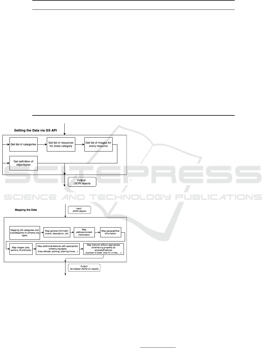
Table 2: An example of the domain specification for SportsActivityLocation.
Domain Types Set of properties Range Type Attributes
SportsActivityLocation name Text required
description Text required
image URL, ImageObject required,
multitype
hasMap Map or URL required
address PostalAddress
PostalAddress addressCountry Text, Country
name Text optional
addressLocality Text required
addressRegion Text required
postalCode Text required
streetAddress Text required
geo GeoCoordinates, GeoShape required
GeoCoordinates longitude Number required
latitude Number required
elevation Number optional
...
Figure 2: Architecture of getting data via API.
Figure 3: Architecture of mapping the data.
you can upload a few hundred JSON files at a time to a
given API-key (linked to an account or organization).
So, with just a few requests all the data is transmitted
and ready for the customer. (?)
5 EVALUATION
We evaluate our annotation model with formally va-
lidation the functional requirements of our domain
specifications with answering the competency ques-
tions (Uschold and Gruninger, 1996). We translate
questions into queries, use SPARQL and to answer
them and hence formally evaluate our ontology (Stolz
et al., 2017). We use Ontotext GraphDB
15
as a soft-
ware product for storing our annotation and querying
them with SPARQL.
As explained in Section 2, the semantic annota-
tions approach was utilized to not only representing
data uniformly but also to obtain reasoning capabi-
lity. Therefore, in the following SPARQL queries, we
discuss the capabilities introduced by semantic anno-
tations with Schema.org.
Question 1. Return all trails with average difficulty
in Seefeld region.
PREFIX rdf: <http://www.w3.org/1999/02/22-rdf-syntax-ns#>
PREFIX schema:<http://schema.org/>
SELECT ?s ?name WHERE
{
GRAPH ?g
{
?s rdf:type schema:SportsActivityLocation.
?s schema:name ?name.
?s schema:amenityFeature ?feature.
?feature schema:name "Difficulty".
?feature schema:value "average".
}.
FILTER(str(?g)="http://maps.seefeld.com")
}
According to the “SportsActivityLocation” spe-
cification of Schema.org
16
, the type covers variety
more specific types such as “BowlingAlley”, “Golf-
Course”, “PublicSwimmingPool”. By using this sin-
gle query, instances of all those specific types will be
15
http://graphdb.ontotext.com/
16
http://schema.org/SportsActivityLocation
Representing GeoData for Tourism with Schema.org
243
also included in the result, in consequence of type and
sub-type relationships.
Question 2. Return all cable cars and their length in
ski resorts of Mayrhofen-Hippach map and with the
altitude of mountain station more then 1815m.
PREFIX rdf: <http://www.w3.org/1999/02/22-rdf-syntax-ns#>
PREFIX schema:<http://schema.org/>
PREFIX dbp: <http://dbpedia.org/resource/>
SELECT ?s ?name ?distance ?elevation WHERE
{
GRAPH ?g
{
?s rdf:type schema:CivicStructure.
?s schema:additionalType dbp:Cable_car.
?s schema:name ?name.
?s schema:potentialAction ?action.
?action rdf:type schema:TravelAction.
?action schema:distance ?distance.
?action schema:toLocation ?place.
?place schema:geo ?geo.
?geo schema:elevation ?elevation.
FILTER (?elevation >= 1815).
}.
FILTER(str(?g)="http://maps.mayrhofen.at")
}
This second query requested instances of “Civi-
cStructure” which have an additional type of “Ca-
ble car” from DBpedia
17
. This is another advan-
tage of using semantic annotations with Schema.org,
where data can be linked with specific types from ex-
ternal vocabularies, for instance to avoid ambiguity.
6 RESULTS
In this section, we discuss results from our work of
annotating geo-data available in the maps of TVB
Mayrhofen-Hippach and Seefeld. First, we describe
the statistics of produced annotations, then discuss in
detail about entities that were annotated with multiple
types.
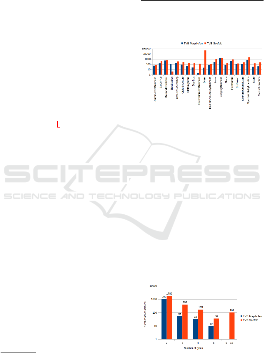
6.1 Annotation
In total, we produced about 58k annotations from both
maps, where an annotation could has exactly one type
or combination of several types known as multi-type
entity (MTE). Table 3 shows the statistics of produced
annotations.
As shown in this table, more than 93% of anno-
tations were produced from geo-data available in the
map of TVB Seefeld, annotated with less than 100
types available in Schema.org. Type “Event” was
dominated the annotation (above 73%), followed by
17
http://dbpedia.org/resource/Cable car
Table 3: Statistics of Produced Annotations.
No. Description
Maps of TVB
Mayrhofen Seefeld
1. Annotations 3.986 53.997
2. Used types 78 97
3. Annotations with MTE 1.096 2.481
Figure 4: Distribution of types usage (top 20).
“LodgingBusiness” (5%), “SportsActivityLocation”
(5%), “Restaurant” (2%), “Hotel” (2%), “BedAndB-
reakfast” (2%), and the other types were used about
less than 1%. About 22% of annotations for TVB
Mayrhofen-Hippach were used MTE and only about
4% for TVB Seefeld.
We examined further the top 20 of types used in
the maps as shown in Figure 4. The most dominant
types found are “LodgingBusiness” and “Event” in
the maps of TVB Mayrhofen-Hippach and Seefeld
respectively. Also, location for doing sport activi-
ties (annotated with type “SportsActivityLocation”)
was dominating annotations in both maps. For mo-
bility support (indicated with type “BusStation”) was
dominated by geo-data available in the map of TVB
Mayrhofen-Hippach.
6.2 Multi-types Entity Annotation
Another important results are entities that were anno-
tated with multiple types. A multi-type entity will be
required whenever the entity can be represented with
Figure 5: Annotations with multiple types.
GISTAM 2018 - 4th International Conference on Geographical Information Systems Theory, Applications and Management
244

a single type. For us, this situation leads us to iden-
tify types that are not covered by Schema.org yet, as
well as to find types that share similar properties. As
shown in Figure 5, an entity could be annotated with
more than one type. While most of them were an-
notated with 2 types, an entity could has up to 5 or
16 types for TVB Mayrhofen-Hippach or Seefeld re-
spectively.
6.3 Discussion
We highlighted the usage of MTE in our annotations
because a point of interest on map could has variety of
organizational functions. Each function was reflected
by a different type. For example, a point of interest
18
has been annotated with 2 types, namely “ClothingS-
tore” and “ShoeStore” to represent 2 different busi-
ness functions offered by the entity. These business
functions were based on categories and sub-categories
defined by the data provider, obtained through the
mapping to the defined types from the selected vo-
cabulary (as explained in Section 4). Another possi-
bility to represent multi-type entities especially those
that related to e-commerce is defining the entity as
“Shop” which offers various types of products such
as “Clothing”, “Bike”, “Shoe”, and so on.
7 CONCLUSION AND FUTURE
WORK
In this paper, we presented a work on representing ge-
ographical data related to touristic information avai-
lable on an interactive map using Schema.org. Our
intention was to provide clear description to all iden-
tified points of interest such that can be consumed by
intelligent application, such as search engines, per-
sonal digital assistants. Although many vocabula-
ries for geographical data specific have been propo-
sed, most of them have failed to get wide adopti-
ons. Since Schema.org vocabulary has been widely
adopted, we believe that our work will gained wider
acceptance from the Internet users. In our work we
analyzed data source and format, identified types and
categories (including sub-categories) of available ob-
jects. For every type and category, proper types from
Schema.org were identified, and domain specificati-
ons were produced. The software tool was developed
to consume the produced mapping, retrieve content
from the API, produce relevant annotations and de-
ploy them to a platform in a way ready to be consu-
med by customers. At the end, we produced about
18
https://maps.seefeld.com/de#resourceDetail,1653626
58k annotations for data obtained from two maps, uti-
lized about 100 different types.
Unfortunately, schema.org doesn’t offer every
possible type and property for the tourism and tra-
vel industry, so a lot of classes and features were just
mapped into a new key-value pair. For example, there
are no specific types for sport locations and activities,
such as: hiking and climbing trails, running and cy-
cling routes and ski slopes, which are so popular for
the Tyrol region. We annotate such objects with the
help of schema’s ”SportsActivityLocation”, ”Loca-
tionFeatureSpecification”, ”TravelAction” and their
properties (e.g. amenityFeature, potentialAction, dis-
tance) to describe the duration, length, start and end
point of a trail and so on. There were also some map-
ping deficiencies, such as: language differences, dif-
ferent concepts and priorities for data types provided
by Feratel, General Solution and schema.org. Also,
it is worth mentioning that in some cases, a data in-
stance might inherit properties from multiple types,
known as a multi-type entity, as some objects appear
in different categories or it is required to use two types
to cover one object with schema.org.
Future work is to provide more specialized vo-
cabularies for the touristic domain to build upon the
core and start the process of extending the schema.org
standard. For this purpose the Schema Tourism Wor-
king Group
19
is running. Our ultimate goal is to have
all tourism related information in the region of Tyrol,
Austria semantically represented on the Web. More
than just providing a high online visibility for the re-
gion on search engines, these data also contribute to
opening new marketing channels such as chatbots and
other intelligent personal digital assistants.
ACKNOWLEDGEMENTS
This work was performed with cooperation and sup-
port from General Solutions, Tirol Werbung GmbH,
TVB Mayrhofen and Seefeld . We would like to
thank all the members of the Schema Tourism Wor-
king Group for their valuable feedback.
REFERENCES
Akbar, Z., Garc
´
ıa, J. M., Toma, I., and Fensel, D. (2014).
On Using Semantically-Aware Rules for Efficient On-
line Communication. In Bikakis, A., Fodor, P.,
and Roman, D., editors, Lecture Notes in Computer
Science (including subseries Lecture Notes in Artifi-
cial Intelligence and Lecture Notes in Bioinformatics),
19
https://schema-tourism.sti2.org/
Representing GeoData for Tourism with Schema.org
245

volume 8620 LNCS, pages 37–51. Springer, Prague,
Czech Republic.
Akbar, Z., K
¨
arle, E., Panasiuk, O., S¸ims¸ek, U., Toma, I., and
Fensel, D. (2017). Complete semantics to empower
touristic service providers. In Panetto, H., Debruyne,
C., Gaaloul, W., Papazoglou, M., Paschke, A., Ar-
dagna, C. A., and Meersman, R., editors, On the Move
to Meaningful Internet Systems. OTM 2017 Conferen-
ces: Confederated International Conferences: Coo-
pIS, C&TC, and ODBASE 2017, Rhodes, Greece, Oc-
tober 23-27, 2017, Proceedings, Part II, pages 353–
370. Springer, Cham.
De Meester, B., De Nies, T., Verborgh, R., Mannens, E.,
and Van de Walle, R. (2015). Reconnecting digital
publications to the web using their spatial information.
In Proceedings of the 24th International Conference
on World Wide Web, WWW ’15 Companion, pages
749–754, New York, NY, USA. ACM.
Fensel, A., Akbar, Z., Toma, I., and Fensel, D. (2016). Brin-
ging Online Visibility to Hotels with Schema.org and
Multi-channel Communication. In Inversini, A. and
Schegg, R., editors, Information and Communication
Technologies in Tourism 2016, pages 3–16. Springer,
Bilbao, Spain.
Fuentes-Lorenzo, D., Fern
´
andez, N., Fisteus, J. A., and
S
´
anchez, L. (2013). Improving large-scale search en-
gines with semantic annotations. Expert Systems with
Applications, 40(6):2287–2296.
Gavalas, D., Kasapakis, V., Konstantopoulos, C., Pantziou,
G., Vathis, N., and Zaroliagis, C. (2015). The eCOM-
PASS multimodal tourist tour planner. Expert Systems
with Applications, 42(21):7303–7316.
Gretzel, U., Mitsche, N., Hwang, Y.-H., and Fesenmaier,
D. R. (2004). Tell me who you are and i will tell you
where to go: Use of travel personalities in destination
recommendation systems. Information Technology &
Tourism, 7(1):3–12.
Kim, H. (2017). Towards a sales assistant using a product
knowledge graph. Web Semantics: Science, Services
and Agents on the World Wide Web.
Kumar, A. J., Schmidt, C., and Khler, J. (2017). A know-
ledge graph based speech interface for question ans-
wering systems. Speech Communication, 92(Supple-
ment C):1 – 12.
Meusel, R., Bizer, C., and Paulheim, H. (2015). A Web-
scale Study of the Adoption and Evolution of the
schema.org Vocabulary over Time. In Proceedings of
the 5th International Conference on Web Intelligence,
Mining and Semantics - WIMS ’15, pages 1–11, New
York, New York, USA. ACM Press.
Panasiuk, O., K
¨
arle, E., S¸ims¸ek, U., and Fensel, D. (2018).
Defining tourism domains for semantic annotation of
web content. ENTER 2018 Conference on Information
and Communication Technologies in Tourism, Rese-
arch Notes in e-Review of Tourism Research, 11.
Rahman, F. and Siddiqi, J. (2012). Semantic annotation of
digital music. Journal of Computer and System Scien-
ces, 78(4):1219–1231.
Ruta, M., Scioscia, F., Ieva, S., Loseto, G., and Di Sciascio,
E. (2012). Semantic Annotation of OpenStreetMap
Points of Interest for Mobile Discovery and Naviga-
tion. In 2012 IEEE First International Conference on
Mobile Services, pages 33–39. IEEE.
Stadler, C., Lehmann, J., H
¨
offner, K., and Auer, S. (2012).
Linkedgeodata: A core for a web of spatial open data.
Semantic Web, 3(4):333–354.
Stolz, A., Hepp, M., and Hemminger, A. (2017). Represen-
ting fashion product data with schema. org: Approach
and use cases. pages 254–272.
Uschold, M. and Gruninger, M. (1996). Ontologies: Princi-
ples, methods and applications. The knowledge engi-
neering review, 11(2):93–136.
Vansteenwegen, P., Souffriau, W., Berghe, G. V., and Oud-
heusden, D. V. (2011). The City Trip Planner: An
expert system for tourists. Expert Systems with Appli-
cations, 38(6):6540–6546.
Vansteenwegen, P. and Van Oudheusden, D. (2007). The
Mobile Tourist Guide: An OR Opportunity. OR In-
sight, 20(3):21–27.
GISTAM 2018 - 4th International Conference on Geographical Information Systems Theory, Applications and Management
246
