
Minecraft in Support of Teaching Sustainable Spatial Planning in
Secondary Education
Lessons Learned from the Marker Wadden-Project
M. Opmeer, E. Dias, B. de Vogel, L. Tangerman and H. J. Scholten
Spatial Information Laboratory (SPINlab), School of Business and Economics, Vrije Universiteit Amsterdam,
The Netherlands
Keywords: Digital Game-Based Learning, Sustainable Patial Planning, Minecraft, Expectations, Experiences.
Abstract: In this article, we have assessed the educational affordances of Minecraft to teach school children about
sustainable spatial planning. Specifically, we carefully examined the expectations and experiences of the
learners and the teachers of this digital game as an educational tool for spatial planning purposes. The
results of this explorative study confirm the educational potential of Minecraft. However, connection
problems and digital vandalism (‘griefing’) by other players may seriously hinder the learning process.
Moreover, it is advised to start with traditional design materials (e.g., paper and pencil) before working in
Minecraft, as learners may find it restricting to be able to build with rectangular blocks only.
1 INTRODUCTION
A lively debate exists on the affordances of digital
game-based learning for education. Since the
beginning of this century, a large body of research
has emerged on the positive and negative aspects
of using digital games for educational purposes
(All et al., 2016; Arnab and Clarke, 2017; Bouvier
et al., 2013; Boyle et al., 2016; Brom et al., 2016;
De Grove and Van Looy, 2011; Favier and van
der Schee, 2014). Although the employed
research strategies variate profoundly, there is
academic evidence that the employment of digital
games may result in higher learning outcomes
(Dankbaar and Saase, 2015; Girard et al., 2013).
However, a large set of factors influence the
effectiveness of these media during the whole
learning process. As such, these aspects have to
be taken into account carefully when using game
technology in an educational context (Hamari et
al., 2016; Perttula et al., 2017; Proulx et al.,
2017).
This paper focusses on the teachers' and
learners' attitudes towards Minecraft as an
educational tool for creating sustainable spatial
plans in secondary education. In 2015, the Spatial
Information Laboratory (SPINlab) of the Vrije
Universiteit Amsterdam partnered with the Dutch
Road Authority (Rijkswaterstaat) to teach school
children about the complexity of designing
sustainable landscape plans. We aimed to assess
whether Minecraft was an appropriate digital
game to engage young learners with this topic in
an appealing and challenging way. Accordingly,
we aimed to answer the following research
question: Is Minecraft an appropriate tool for
teaching the fundamentals of sustainable spatial
planning in secondary education? We tried to
answer this question with the outcomes of a pre-
and postquestionnaire and by interviewing the
involved teachers.
2 BACKGROUND
2.1 Project Description
From 2015 onwards, SPINlab has investigated
how Minecraft can help to teach sustainable
spatial planning in high-school education. We
chose Minecraft because of its unique 3D
representation of the physical world, the
possibility to implement official spatial data of the
Kadaster (Dutch Ordnance Survey) to reconstruct
316
Opmeer, M., Dias, E., de Vogel, B., Tangerman, L. and Scholten, H.
Minecraft in Support of Teaching Sustainable Spatial Planning in Secondary Education.
DOI: 10.5220/0006764403160321
In Proceedings of the 10th International Conference on Computer Supported Education (CSEDU 2018), pages 316-321
ISBN: 978-989-758-291-2
Copyright
c
2019 by SCITEPRESS – Science and Technology Publications, Lda. All rights reserved

urban and rural environments from the physical
world, and the easy learning curve of this digital
game. The immense popularity of this game and
the ability to alter specific mechanisms through
‘mods’ and ‘plugins’ also contributed to our
decision.
In a project-based assignment, the children of
the Technasium in Lelystad (the Netherlands)
were challenged by Rijkswaterstaat to develop
sustainable spatial plans for the second phase of
the Marker Wadden (‘Marker islands’) in Lake
Markermeer. Together with the National Nature
Conservation Agency (Natuurmonumenten) and
the dredging company Boskalis N.V.,
Rijkswaterstaat aimed to improve the water
quality and biodiversity of the Markermeer-lake
by creating islands with silt from the bottom of
the lake. The construction of the Houtribdijk in
the 1950s from Enkhuizen to Lelystad had
blocked the flow of silt to open sea, and as such,
during the second half of the 20th century, the
vegetation of Lake Markermeer was covered by a
thick layer of mud. To restore the water quality
and biodiversity, islands were created with this
silt during phase one of the Marker Wadden-
project between 2013 and 2015.
School children were asked to investigate the
possibility to use the islands not only to enhance
the ecological quality of the area but also to
generate sustainable energy (e.g., solar, wind,
water power) and/or to create places where people
can recreate (e.g., a harbor and visitor center). For
this, we reconstructed in Minecraft the complete
Markermeer, the islands and the landscape objects
that lay around this lake. This virtual environment
functioned as the canvas that the school children
could use for their three-dimensional spatial
designs.
2.2 Minecraft
Minecraft is a so-called open world game,
released in 2011 by the Swedish company
Mojang. Two game modes are provided: survival
and creative. The survival mode allows the player
to roam in a borderless (open) world. The primary
goal is to survive in an environment full
of dangerous creatures by building a house and
producing food. In the creative mode, on the other
hand, players already have access to all
the materials and tools, which allows them to
build anything that they can imagine. This mode
proves to be an excellent starting point to engage
learners in sustainable spatial planning. Moreover,
the multiplayer option allows players to work
together on the assignment.
Location plays an important factor in
Minecraft. The open world consists of different
regions with their own (visual) characteristics,
place identity, and ecosystems. To navigate in this
virtual world, the player has to think in a three-
dimensional way as it is possible to move freely
in all kinds of directions. Reasoning about
distances, directions, and movement fosters the
spatial thinking process. The game stimulates
school children to use their mental rotation skills
to create, adjust, destroy and recreate entire
landscapes and objects. As such, various scholars
have argued that Minecraft can efficiently
contribute to the development of the learners'
geographical and spatial thinking capabilities
(Mørch and Thomassen, 2016; Nebel et al., 2016;
Nguyen and Rank, 2016; Scholten, 2017).
Four game characteristics of Minecraft prove
to be very interesting for educational purposes. In
the first place, the player can design entire
landscapes with its unique architecture, flora, and
fauna. Some players reconstruct existing places
and objects, such as the Eiffel tower or Dam
Square in Amsterdam; others create fantasy
worlds with castles, dungeons, and dragons. An
entire world can be created with the use of
rectangular blocks.
These Lego-like blocks have their own
characteristics and textures and represent the
building materials of the physical world. With
these blocks, players can, for example, transform
“silt-blocks” into grass or stone. Or they can
create buildings with various "wood- or stone-
blocks”. This high level of interactivity is a
second game mechanism, which makes Minecraft
attractive for educational purposes.
Thirdly, Minecraft stimulates players to work
together on a specific building project.
In particular, children find it very engaging to
"meet" in the virtual Minecraft world and to chat
about daily life, as well as to impress each other
with their building skills and creations. As such,
Minecraft is a safe environment, where young
people can escape from reality.
Fourth, the massive popularity of Minecraft
has resulted in the creation of numerous "mods"
and "plugins" to change the game mechanics and
appearance of the game in many ways. The large
Minecraft in Support of Teaching Sustainable Spatial Planning in Secondary Education
317

Minecraft community is one of the reasons why
this game, since its release in 2011, is still trendy
among children.
Lastly, another advantage of Minecraft is its
capability to load official GIS datasets into the
game environment. Together with the GEO-ICT
company, Geodan B.V. the SPINlab used a
Python computer script to implement these spatial
datasets into the game environment. Complete
areas can be integrally loaded in Minecraft
without the need to build everything manually. It
was, therefore, possible to integrate the whole
Netherlands in the Minecraft game environment.
Because of these characteristics, we posited
that Minecraft is a suitable digital game to employ
for an educational project on sustainable spatial
planning.
3 METHODS AND PROCEDURE
3.1 Project Design and Planning
To explore the educational affordances of
Minecraft, SPINlab, Rijkswaterstaat, and the
dedicated teachers have worked together on a
lesson plan and an instruction booklet. In July
2015, the case study and learning goals were
formulated, and a schedule was created to
highlight essential activities and (preliminary)
project deliverables. Subsequently, the teachers
worked on a more detailed lesson plan and hand-
out. At the end of August, all three partners
agreed on the final version of lesson plan and the
learners' instruction booklet.
The following lesson goals were formulated
for the Marker Wadden project:
The school children can:
1. explain in their own words which
spatial data can help them in creating
a sustainable spatial planning;
2. perform a multicriteria analysis to
decide how the implementation of the
functions energy or recreation can be
combined with the function nature in
the spatial design of the islands;
3. create a draft of their spatial plan on
scale on paper. They can motivate
their decisions and are capable of
receiving feedback from classmates
and domain experts from
Rijkswaterstaat;
4. implement the gathered feedback in a
new, three-dimensional version of the
spatial design in Minecraft;
5. can present their final versions of
their spatial designs in Minecraft.
The school children had to use spatial GIS data
that was provided by SPINlab to assess the
suitability of these islands for sustainable energy
or recreation purposes. Because the Marker
Wadden were initially created to enhance the
water quality and biodiversity of the Markermeer,
the energy or recreation plans may not interfere
with the ecological aims of the islands. As such,
before developing a detailed spatial plan, the
school children had to perform a multicriteria
analysis with the available spatial data first.
Subsequently, a two-dimensional draft version of
the spatial plan had to be created and presented.
Finally, the school children were asked to
implement the gathered feedback in a definite,
three-dimensional design in Minecraft and present
it to the domain experts of Rijkswaterstaat.
In September, at the beginning of the new
school year, school children in the eighth grade of
the pre-university education worked in groups of
three or four on this assignment until the final
presentation on 10 December 2015.
3.2 Research Design and Instruments
To successfully help the school children with a
virtual representation of Lake Markermeer and
phase one of the Marker Wadden in Minecraft,
three members of the SPINlab were responsible
for three different tasks: 1) project-management,
2) research and communication, 3) data and
technical infrastructure. A Ph.D. candidate was
responsible for the aims of the lesson plan,
research design, measurements, and
communication with the teachers. The project
manager was responsible for the budget and
communication with the software provider
(Teacher Gaming – MinecraftEdu, see description
in the following section). A data engineer was
responsible for the installation of the
MinecraftEdu client software on the school
computers, the preparation and configuration of
the Minecraft environment, and the
CSEDU 2018 - 10th International Conference on Computer Supported Education
318
communication with the ICT department of the
school (e.g. for configuring the firewall).
A quasi-experimental design was employed to
measure the school children's expectations of and
experience with Minecraft as a tool for sustainable
spatial planning. After the instruction, school
children were asked to answer two open questions
on paper:
1. What are the advantages of Minecraft
for creating a spatial plan for phase
two of the Marker Wadden? Please
explain your answer.
2. What are the disadvantages of
Minecraft for creating a spatial plan
for this project? Please explain your
answer.
The same questions were posed to the school
children at the end of the project.
Table 1: Quasi-experimental research design.
September December
Class Pre-
questionnaire
Pos
t
-
questionnaire
A3B
(12-15
y
ear)
Expectations
of Minecraft
(n=23)
Experiences
with Minecraft
(n=23)
3.3 Materials and equipment
A modified version of Minecraft was used for this
project: MinecraftEdu. MinecraftEdu has been
developed by the Finnish company Teacher
Gaming and is specially created for educational
purposes. It allows teachers to adjust the server
settings in an easy to use dashboard interface.
They can, for example, disable natural disasters
(lava) or the appearance of predators (wolves) to
create a digital environment that is solely suitable
for learning and spatial planning practices.
Moreover, the teachers can use the dashboard to
monitor the activities of their pupils and instruct
them with in-game messages.
Besides a client and server MinecraftEdu
license, Teacher Gaming also provided a service
for hosting the servers. We chose this option
for practical reasons.
The Markermeer in Minecraft was created
from the following GIS datasets: elevation data
(AHN2), land use data (TOP10NL), and building
footprints (BAG). All these datasets are open data
and cover the whole of the Netherlands.
Table 2: Total costs of the MinecraftEdu license and
hosting for this project.
Service Quantity Unit price
(in US dollars)
MinecraftEdu
User License
23 $ 14
MinecraftEdu
Server License
12 $ 41
MinecraftEdu
Hosting (per
month)
6 $ 30 x 4
months = $ 120
Total costs $ 175,00
4 RESULTS AND DISCUSSION
4.1 Results
As stated above, we asked the school children two
questions at the beginning of the project in
September and the same two questions after
presenting their final spatial plans for the Marker
Wadden to Rijkswaterstaat in December.
To question 1, about the expected advantages
of Minecraft for this project, the children
responded that the ability to assess the spatial plan
from different angles proved to be one of the key
strengths of this digital game for this assignment.
In the post-test questionnaire, the school children
still argued that the ability to get a good overview
of the design is one of the critical strengths of
Minecraft. They also responded that the ability to
work together on the project was one of the key
strengths of Minecraft for this learning task.
To question 2, about the disadvantages of
Minecraft, the school children responded in the
pretest that the unrealistic representation of
Minecraft of the physical environment might
make it difficult to create a realistic spatial design
wherein nature and energy or recreation is
implemented. Also, the lack of causality and the
simulation of natural effects is regarded as a
limitation of using Minecraft for this assignment.
After the project, the school children regarded the
lack of these functionalities still as a limitation of
Minecraft. However, more surprisingly, technical
issues such as server crashes and digital
vandalism by other players (‘griefing’) have been
reported as the most important negative aspect of
using Minecraft for educational purposes.
Minecraft in Support of Teaching Sustainable Spatial Planning in Secondary Education
319

Overall, the teachers were highly positive
about the options that Minecraft provided for
teaching school children about sustainable spatial
planning. The ability to walk and fly through a
digital reconstruction of the physical world and
the use of a 1-by-1 scale has been mentioned as
two significant advantages of Minecraft.
Moreover, the need to work together and to
explain each other's design choices has also been
regarded as a positive aspect of this digital game,
because it fosters the reflective engagement of the
learners. By explaining what one is doing and
why the school children looked more aware of
their choices and decision. The interactive, real-
time world of Minecraft stimulates school
children not only to build but also to communicate
about the spatial planning process.
The teachers did witness however that a large
group of school children relied heavily on their
two-dimensional paper blueprints during the
three-dimensional enhancement of their spatial
design in Minecraft. In specific circumstances, the
children preferred to draw lines on paper instead
to build with blocks in Minecraft. This suggests
that Minecraft should be used together with other
educational materials (e.g., paper and pencil) to
teach the principles of creating sustainable spatial
plans effectively.
4.2 Discussion
The results of this study confirm the affordances
of Minecraft for educational purposes. However,
we have learned that some factors have to be
taken into account to implement this digital game
in an educational context efficiently.
In the first place, it is highly advised to use a
reliable technical infrastructure. The connection
should be very stable, and the preliminary
Minecraft-designs have to be regularly back-
upped.
Secondly, access to the Minecraft-servers
should be restricted to individual school children
to prevent digital vandalism (‘griefing’) by
classmates. To our knowledge, Minecraft-servers
cannot be protected with a password. A so-called
white-list (a list with verified names) might be a
solution for this matter.
Thirdly, it is crucial to regard Minecraft as a
tool for spatial planning and not as a means to an
end. Other educational materials, such as the use
of paper and pencil are also beneficial for the
design and learning process. Accordingly, we
argue that Minecraft should be introduced when
the children already have received feedback on
the first version of their spatial plan. Minecraft
can be used as a spatial design tool for translating
this two-dimensional concept map into a three-
dimensional, digital spatial design. Since thinking
in a three-dimensional perspective can be
challenging, it is helpful if they already have a
(general) idea about the spatial plan they want to
create.
Future research of the SPINlab on Minecraft
will focus on the affective and cognitive impact of
this digital game in secondary education. In an
experimental research design, we will try to assess
to what extent Minecraft fosters the knowledge
acquisition of school children and how this game
enhances the learners' motivational and cognitive
engagement. Accordingly, we aim to contribute to
the scientific debate about the effectiveness of
digital games in general, and Minecraft in
particular, for teaching sustainable spatial
planning.
ACKNOWLEDGEMENTS
The authors would like to thank the school
children and the teachers of the Technasium in
Lelystad for helping us conducting this research.
We furthermore thank the reviewers for their
constructive feedback for improvement.
FUNDING
This work was supported by Rijkswaterstaat
under grant number 31108874.
REFERENCES
All, A., Nuñez Castellar, E.P., Van Looy, J., 2016.
Assessing the effectiveness of digital game-based
learning: Best practices. Comput. Educ. 92–93, 90–
103. https://doi.org/10.1016/j.compedu.2015.10.007
Arnab, S., Clarke, S., 2017. Towards a trans-disciplinary
methodology for a game-based intervention
development process: Towards a trans-disciplinary
methodology. Br. J. Educ. Technol. 48, 279–312.
https://doi.org/10.1111/bjet.12377
Bouvier, P., Lavoué, E., Sehaba, K., George, S., 2013.
Identifying Learner’s Engagement in Learning Games-
CSEDU 2018 - 10th International Conference on Computer Supported Education
320
A Qualitative Approach based on Learner’s Traces of
Interaction., in: CSEDU. pp. 339–350.
Boyle, E.A., Hainey, T., Connolly, T.M., Gray, G., Earp,
J., Ott, M., Lim, T., Ninaus, M., Ribeiro, C., Pereira,
J., 2016. An update to the systematic literature review
of empirical evidence of the impacts and outcomes of
computer games and serious games. Comput. Educ.
94, 178–192. https://doi.org/10.1016/j.compedu.2015
.11.003
Brom, C., Šisler, V., Slussareff, M., Selmbacherová, T.,
Hlávka, Z., 2016. You like it, you learn it: affectivity
and learning in competitive social role play gaming.
Int. J. Comput.-Support. Collab. Learn. 11, 313–348.
https://doi.org/10.1007/s11412-016-9237-3
Dankbaar, M.E.., Saase, J. van, 2015. Serious games and
blended learning. Effects on Performance and
Motivation in Medical Education = Serious games en
blended leren/Effecten op Prestaties en Motivatie in
het Medisch Onderwijs. Erasmus Universiteit
Rotterdam, Rotterdam.
De Grove, F., Van Looy, J., 2011. Computerspellen in het
onderwijs.
Favier, T.T., van der Schee, J.A., 2014. The effects of
geography lessons with geospatial technologies on the
development of high school students’ relational
thinking. Comput. Educ. 76, 225–236. https://doi.org
/10.1016/j.compedu.2014.04.004
Girard, C., Ecalle, J., Magnan, A., 2013. Serious games as
new educational tools: how effective are they? A
meta-analysis of recent studies: Serious games as
educational tools. J. Comput. Assist. Learn. 29, 207–
219. https://doi.org/10.1111/j.1365-2729.2012.00489
.x
Hamari, J., Shernoff, D.J., Rowe, E., Coller, B., Asbell-
Clarke, J., Edwards, T., 2016. Challenging games help
students learn: An empirical study on engagement,
flow and immersion in game-based learning. Comput.
Hum. Behav. 54, 170–179. https://doi.org/10.1016/
j.chb.2015.07.045
Mørch, A.I., Thomassen, I., 2016. From Wooden Blocks
and Lego to Minecraft: Designing and Playing with
Blocks to Learn in a 3D Virtual World.
Nebel, S., Schneider, S., Rey, G.D., 2016. Mining learning
and crafting scientific experiments: a literature review
on the use of minecraft in education and research. J.
Educ. Technol. Soc. 19, 355–366.
Nguyen, A., Rank, S., 2016. Spatial Involvement in
Training Mental Rotation with Minecraft. ACM Press,
pp. 245–252. https://doi.org/10.1145/2968120
.2987747
Perttula, A., Kiili, K., Lindstedt, A., Tuomi, P., 2017.
Flow experience in game based learning – a systematic
literature review. Int. J. Serious Games 4.
https://doi.org/10.17083/ijsg.v4i1.151
Proulx, J.-N., Romero, M., Arnab, S., 2017. Learning
Mechanics and Game Mechanics Under the
Perspective of Self-Determination Theory to Foster
Motivation in Digital Game Based Learning. Simul.
Gaming 48, 81–97. https://doi.org/10.1177/
1046878116674399
Scholten, H., 2017. Geocraft as a Means to Support the
Development of Smart Cities, Getting the People of
the Place Involved - Youth Included -. Qual. Innov.
Prosper. 21, 119. https://doi.org/10.12776/qip.v21i1
.784
APPENDIX
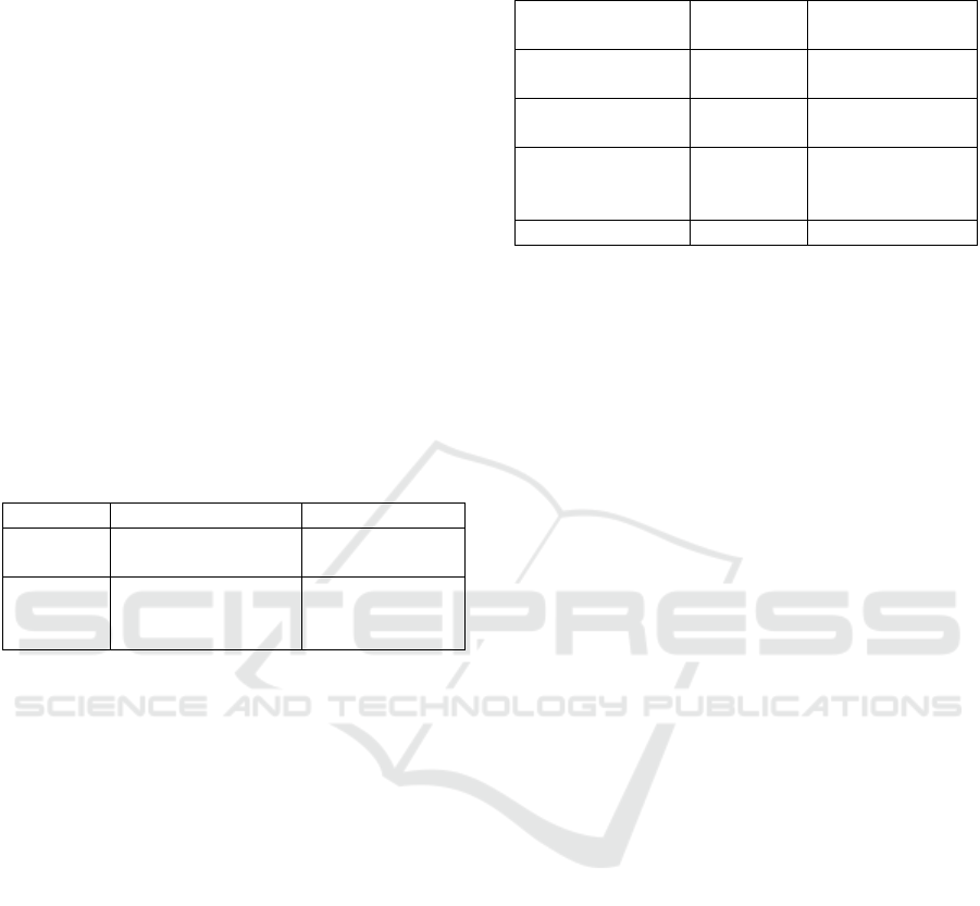
Figure 1.
Figure 2.
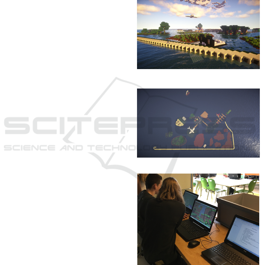
Figure 3.
Figure 1 and 2: School children’s impression of
phase two of the Marker Wadden project: room for
nature and recreation. Figure 3: Working together on
the three dimensional spatial design in Minecraft.
Minecraft in Support of Teaching Sustainable Spatial Planning in Secondary Education
321
