
Introducing Cellular Network Layer into SUMO for Simulating
Vehicular Mobile Devices’ Interactions in Urban Environment
Siim-Toomas Marran, Artjom Lind and Amnir Hadachi
ITS Team, Institute of Compute Science, University of Tartu,
¨
Ulikooli 17, 51014, Tartu, Estonia
Keywords:
Simulation, Mobility Big Data, Call Detail Records, Cellular Networking, Urban Road Traffic, GPS Devices,
Mobile Devices, SUMO.
Abstract:
During the last decade researchers have been demonstrating the importance of mobile data or CDR data in
depicting the human mobility patterns. However, this type of data is not easy to get access to from mobile
operators. Besides, in order to make this type of data available and enable their usage for the scientific com-
munities the process can face many constraints that can constitute obstacle. From this perspective, this paper
introduces a way to produce realistic real-life mobility logs through the traffic simulation tool SUMO, which
has been enhanced with a cellular network layer to mimic cellular networking behavior.
1 INTRODUCTION
The mobility data is a broad connotation that refers
to a various types of data, which describes people’s
movement and activities. Some of the common types
of the mobility data are Call Detail Records (CDR)
(Hadachi et al., 2014), Global Positioning System
(GPS) logs (Hadachi et al., 2013), Vehicular ad hoc
network (VANET) logs (Karnadi et al., 2007), Radio-
frequency identification (RFID) system logs (Finken-
zeller and M
¨
uller, 2010), WiFi access points rela-
ted data (Bulut and Szymanski, 2013), etc. Moreo-
ver, with all the advancement in information and tele-
communication technologies (ICT). Mobile data has
a great potential in sensing the urban mobility dy-
namics. From this perspective, it is clear that mo-
bile data or CDR data are valuable. In general, CDR
are data records, produced inside of the cellular net-
work between the user equipment and the base sta-
tion, documenting various telecommunication tran-
sactions. Besides, it is estimated according to (Sta-
tista, 2017) that 4.77 billions mobile users produce
daily unimaginable amount of data, with restricted
access. The mobility big data has been used for de-
veloping many different algorithms and applications
such as triangulation and trilateration, Kalman filter
for mobile positioning (Lind et al., 2017) , hand-
ling the crowd management (Pan et al., 2013) , de-
ploy real-time incident detection solutions (Zaldivar
et al., 2011) , manage and avoid congestions in the
traffic ,develop Vehicle-To-Infrastructure (V2I) appli-
cations , bind the mobility with various Internet of
Vehicles (IoV) and Geographic Information Systems
(GIS) to achieve new systems upgraded with the hu-
man activity related functionality. As a consequence,
there occur moments when it is not feasibly easy to
acquire real data for specific purpose, we rely on si-
mulating and generating synthetic data based on mat-
hematical models. For example, we have open source
SUMO simulator (DLR, 2017) that provides the abi-
lity to simulate real-life urban traffic at microscopic
level. This open source simulation package provi-
des realistic simulation due to the OpenStreetMap
(OSM) (OSM, 2017) map import functionality and
in-built configurable behavior models. The routable
entities can be equipped with various devices. In this
paper, we are integrating we are integrating SUMO
with mobile and GPS devices. Hence, we introduced
also a cellular network layer with all its functionalities
linking the routable devices and the network. This al-
lows us to generate from the microscopic traffic simu-
lator the associated CDR and GPS logs, which can be
later used for the training and testing various machine
learning models in the real life context.
2 RELATED WORK
SUMO is a suite of applications to prepare and to si-
mulate various real-life traffic scenarios. Therefore, it
has been used for many intelligent transport systems
582
Marran, S., Lind, A. and Hadachi, A.
Introducing Cellular Network Layer into SUMO for Simulating Vehicular Mobile Devices’ Interactions in Urban Environment.
DOI: 10.5220/0006808305820589
In Proceedings of the 4th International Conference on Vehicle Technology and Intelligent Transport Systems (VEHITS 2018), pages 582-589
ISBN: 978-989-758-293-6
Copyright
c
2019 by SCITEPRESS – Science and Technology Publications, Lda. All rights reserved

related research topics. For example, the project Traf-
ficOnline is a good illustration of the use of SUMO
for simulating the usage of mobile phone data, where
the real-world GSM data was used to develop a telep-
hony model (consisting of the following properties:
call start, call duration), to determine the travel times
(Krajzewicz et al., 2012). However, the dynamic pro-
perties, e.g. cell size variations, cell changing mecha-
nics, of the GSM network were not considered.
Another related research topic is VANET simulati-
ons. The researcher tried to create an integration
between the traffic simulator SUMO and third party
network simulators, such as OMNet++ (OMNeT++,
2017), where they have created bidirectionally cou-
pled hybrid simulators and Viens (Sommer et al.,
2008). Besides, the list is long for example there
are also NS-2 (ns 2, 2017) and NS-3 (ns 3, 2017)
that have been used for VANET system’s for de-
tailed and realistic performance evaluation. Similar
to Veins, TraNS (Traffic and Network Simulation En-
vironment) based on NS-2, was introduced to com-
bine two disjointly developed research simulators into
one in order to deal with VANET performance evalu-
ation (Piorkowski et al., 2008). The NS-3 was in-
troduced as replacement to NS-2 and it was used in
the VANET crossroad scenario to evaluate the per-
formance of HWMP, OLSR and DD routing proto-
cols, while using IEEE 802.11p standard and Two-
RayGround Propagation Loss Model, to send multiple
Constant Bit Rate (CBR) flows over UDP between 20
source-destination pairs. (Kolici et al., 2015)
Furthermore, we have the emergence of the vehi-
cular networking concept, where the vehicle is con-
nect to everything. Therefore, the birth of many
type of communications related to VANET such
as Vehicle-To-Everything (V2X), vehicle-to-vehicle
(V2V), and vehicle-to-infrastructure (V2I). The main
purpose of introducing the connectivity into the vehi-
cle to solve issues related to traffic control and ma-
nagement via the share or collection of reliable in-
formation from the vehicles. For this purpose, many
simulators have been created such as VSimRTI (We-
del et al., 2009). Obviously VANET solutions aren’t
only viable solutions to tackle the road traffic esti-
mation problem. Due the widespread of the mobile
communications we can estimate the traffic density
on the bigger and more important roads with the help
of cellular network, since many commuters are car-
rying mobile devices with them. Such approach has
proved to be accurate and very capable to detect and
quantify state changes (Bolla and Davoli, 2000).
3 SYSTEM DESIGN AND
ARCHITECTURE
The purpose of this simulation is to produce CDR-
like activity logs with the help of microscopic road
traffic simulator SUMO, where we added an extra
layer – cellular networking. This integration of a new
layer introduces to SUMO’s core and support packa-
ges many changes and new features.
3.1 Models
The most important step in the process of integrating
the cellular network into SUMO is to define the mo-
dels of each new component. The new models can
be divided into two main categories: Cellular network
layer and devices. The cellular network layer contains
the following elements:
Cellular Tower has been added to the cellular net-
work layer with following properties: the Cartesian
coordinates; real life Geo-spatial information; list of
cellular antennas attached to the tower and keeps the
list of connected mobile devices’ references. Cellu-
lar Antenna is also known in the cellular network as
a transmitter. Antennas are entities attached to the
cellular towers. The model has the following proper-
ties: coverage as a polygon shape (e.g.hexagon, cus-
tom polygons are also supported); signal strength; fre-
quency, radius; reference to its tower and an id value,
which represents Common Gateway Identifier (CGI)
value. Mobile Event Data is a data structure model to
describe a mobility event for a certain routable entity.
Concerning the devices added to the simulator can be
resumed to the GPS and mobile devices and they are
defined as follows: GPS Device is, in the simulator
context, a device which can be attached to the routa-
ble entity like pedestrian, vehicle, bicycle etc. Mobile
Device is a device that generate the mobile event data,
attachable to the routable entity.
3.2 Core Mechanics of the Simulation
The core mechanics of the road traffic simulation
SUMO has been gathered into one class which con-
tains the road network and orchestrates the simula-
tion. This class is initialized during the start of the
program and is given to the network builder as a re-
ference to create the infrastructure for the simula-
tion. During the road network building, the cellular
network is being loaded into the simulation network.
Then, when the simulation performer has all the vital
dependencies, then the simulation cycle starts. The
core of the simulation contains of multiple event con-
trollers, which are being ran after every tick. The si-
Introducing Cellular Network Layer into SUMO for Simulating Vehicular Mobile Devices’ Interactions in Urban Environment
583

mulation have been divided into four components ac-
cording to their event controller action types and in-
termediate smoothing and they are as follows:
Begin of time step events is the original event con-
troller in SUMO, which, as an example, takes care of
traffic light events, trigger type events(lane speed, re-
routing), routing device, and pedestrian move events.
Intermediate actions, depends on the previous event
control cycle and smooths the network for the next
event control cycle. During this process, the system is
detecting regularly for collisions, checking the traffic
lights, checking if the edges are active, plans the vehi-
cles movement, executing the vehicles movement, run
lane changes, load new routes and mobile events for
the cellular simulation, insert new vehicles to the net-
work, insert new events, etc. During the execution of
vehicles movement, there is a case when the vehicle
has arrived to the destination and, immediately after-
wards, the vehicle shall be removed from the simula-
tion. This function has been altered to have checks for
existing mobility devices (GPS, mobile) to run their
last events immediately and then invalidating those
events to stop them from recurring. This entire code
alternation prevents losing event data due the prema-
ture removal of the vehicle. End of time step events
is an event running cycle which runs the events depen-
dent on the updated location of the routable elements.
There are also step by step logger events, vehicular
devices specific events (Bluetooth, GPS, mobility ma-
nagement related state update) and vehicle flow ca-
librator events. Mobility events is a newly added
event running cycle entirely for the purpose of mo-
bility event simulation. The events are created by the
mobile devices from the data, which has been atta-
ched to the vehicle after it has been loaded into the
simulation during the intermediate actions.
3.3 Data Import and Export
The simulator depends on the data which has been
prepared beforehand for the simulation and therefore
imported into the application through Extensible Mar-
kup Language (XML) files. SUMO has in its package
multiple programs which help to produce the network
and other simulation related data in XML document
format to run the simulation properly. For the cel-
lular networking layer, there were created multiple
XML data import handlers and their respective XML
Schema Definition (XSD) files. First, cellular net-
work related data like antennas and their respective
transmitters with coverage areas. Second, mobile
events data, which were described in the Section 3.1.
For the export there were designed output XML for-
mats for the GPS and mobile devices. When the spe-
cific routable entity finished the navigation in the net-
work then all its devices data were exported into the
resulting XML file.
4 SIMULATOR
IMPLEMENTATION
The implementation of cellular network log genera-
tor and it’s integration into SUMO base code was
done based on introducing two prerequisite applica-
tions: Mobility Event Simulation Generator (MES-
GEN) and Cell Coverage Area Generator (HEXA-
GEN).
4.1 MESGEN
Mobility Event Simulation Generator (MESGEN) is a
supplementary application required by the main simu-
lator application. MESGEN is responsible for genera-
ting the cellular events-time-line for each vehicle (cel-
lular device inside vehicle). SUMO simulator uses
the cellular events-time-line to trigger the events in
certain cell towers during the simulation when vehi-
cle traverses the corresponding coverage area. Se-
veral cellular activity profiles have been defined and
are illustrated in Table 1. Each profile is specified
by three attributes: frequencies of calls, SMS or and
data usage activities. The events generated by MES-
Table 1: User cellular activity profiles (counting amount of
events per hour). The numbers in the table correspond to
events frequency as follows: none (0), low (1), medium (2)
and high (3).
Profile Calls SMS Data
Casual 1 1 1
Only Keep Alive 0 0 0
Business 3 1 1
Teenager 1 3 2
Student 1 1 2
Talkative 2 1 1
Media streamer 1 1 3
GEN are similar to those of cellular event data mo-
del (original model was simplified by removing not
used events). The MESGEN event types are illustra-
ted in Table 2. The simplified flowchart of the cel-
lular mobility management entity is illustrated in Fi-
gure 2. For example MESGEN events SMS SEND and
SMS REC occur mimics the sequence of cellular net-
work equipment activities that result in delivering an
SMS message (send or receive). MESGEN genera-
tes a history of events for each vehicle participating
in simulation using the simulation life-time, vehicle
activity profiles, road network information and cell
VEHITS 2018 - 4th International Conference on Vehicle Technology and Intelligent Transport Systems
584
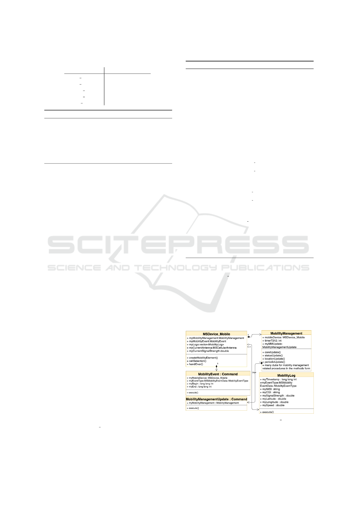
Table 2: MESGEN event type descriptions.
Message Type Description
SMS REC SMS Received
SMS SEND SMS Sent
CALL INIT Calling out
CALL REC Receiving a call
WEB COM Uses mobile data
Listing 1: The appearance of the MESGEN output file.
<vehicles>
<vehicle id="0" depart="0.00">
<mEvents>
<mEvent begin="114.00" end="137.00" type="CALL_REC"/>
<mEvent begin="363.00" end="450.00" type="WEB_COMM"/>
<mEvent begin="490.00" end="516.00" type="CALL_INIT"/>
<mEvent begin="627.00" end="669.00" type="CALL_INIT"/>
<mEvent begin="731.00" end="742.00" type="CALL_REC"/>
<mEvent begin="829.00" end="856.00" type="CALL_INIT"/>
</mEvents>
</vehicle>
</vehicles>
coverage areas. The result events are associated to a
vehicle and have time specified as an offset of SUMO
simulation life-time. An example of MESGEN out-
put is illustrated in the Listing 1 having vehicles with
associated cellular events. The pseudo code in the Al-
gorithm 1 illustrates the algorithm used in MESGEN
generator.
Minimum length and maximum length of diffe-
rent events can be configured through constant varia-
bles. It is also possible to define time buffers between
occurring events. The values of low and medium fre-
quency events thresholds and random number seed
can also be set through the configuration file.
4.2 HEXAGEN
HexagonGen is an accessory level script, written in
Python, to generate 120 °sectorized cells for the cel-
lular network behaviour simulation. It takes an in-
put of latitude and longitude coordinate values, size
(length of hexagons side), hexagon network width,
and height values. The given coordinate pair is the
center of the drawn network (tower position). The
result of the HexagonGen is an XML file which con-
tains the cell coverage elements and can be fed di-
rectly into SUMO.
5 MOBILITY BEHAVIOUR AND
MANAGEMENT
5.1 Microscopic Simulation Devices
SUMO provides basic interfaces to communicate with
the vehicle and abstract methods, which need to be
implemented to develop a working device.
GPS device (MSDevice
GPS class in the code) is a test
device, it was created with the objective to study
Algorithm 1: Mobile’s events generator.
Precondition: V ∈ N set of vehicles, P ∈ N
3
set of profiles, T ∈ N vehicle departure
times, l
call
maximal call duration, l
sms
maximal interval between sending SMS,
l
data
maximal web surfing duration, E set of event types as was specified in Table
2
1: function TRIGGEREVENT(e,t, l)
2: Triggers event of type e ∈ E at t, lasting l sec.
3: end function
4: function RAND(n
0
,n
1
)
5: n ∼ U([n
0
, n
1
]) random number from (n
0
, n
1
)
6: return n
7: end function
8: function MESGENVEHICLE(v,t
start
, t
end
)
9: n
calls
,n
sms
,n
data
← P
v
mobile profile of v
10: n
all
=
∑
P
v
11: t ← T
v
departure time of v
12: while t
end
−t ≤ 0 do
13: n = RAND(0, n
all
)
14: if n ≤ n
calls
then
15: l = RAND(0, l
call
) Call duration
16: if RAND(0, 1) > 0.5 then Call direction
17: TRIGGEREVENT(CALL
INIT,t, l)
18: else
19: TRIGGEREVENT(CALL REC,t, l)
20: end if
21: t ← t +l
22: else if n ≤ n
calls
+ n
sms
then
23: if RAND(0, 1) > 0.5 then SMS direction
24: TRIGGEREVENT(SMS SEND,t,0)
25: else
26: TRIGGEREVENT(SMS REC,t,0)
27: end if
28: t ← t + RAND(0, l
sms
)
29: else
30: l = RAND(0, l
data
) Web Surfing Duration
31: TRIGGEREVENT(WEB COM,t, l)
32: t ← t +l
33: end if
34: end while
35: end function
36: function MESGENALL(t
start
, t
end
)
37: for all v ∈ V do MESGENVEHICLE(v,t
start
, t
end
)
38: end for
39: end function
SUMO simulation cycle for the upcoming mobility
device. MSDevice GPS has two subclasses called Rou-
teGPSInfo and GPSSignalUpdate. RouteGPSInfo is a
data structure that records geographical coordinates
and the timestamp. GPSSignalUpdate represents GPS
signal, it is an extension of SUMO’s Command class
(base SUMO microsim event class). During every si-
mulation step, if the vehicle has a device, the event is
triggered the vehicles movement.
Figure 1: The class diagram of MSDevice Mobile and its
sub-entities.
Introducing Cellular Network Layer into SUMO for Simulating Vehicular Mobile Devices’ Interactions in Urban Environment
585
Mobile device (MSDevice Mobile class in th code) is
emulating multiple functions, which in real GSM
stack are performed by several logical units. Next
section will explain how mobile device simulation is
performed. Figure 1 illustrates how mobile device
component is integrated into SUMO and how does it
interact with other modules.
5.2 Mobility Management
During the simulation the state of mobile device is
managed by MobilityManagement. The state is upda-
ted at the end of each simulation step event. Vehi-
cles are initialized based on the parameters file, which
specifies what devices are equipped (mobile, GPS,
etc). Mobility management entity is only created in
case of vehicle being equipped with a mobile device.
MobilityManagementUpdate is an extension of SUMO
Command base abstract event class and is responsi-
ble for triggering the state update. The new state is
assigned based on previous one, the state transitions
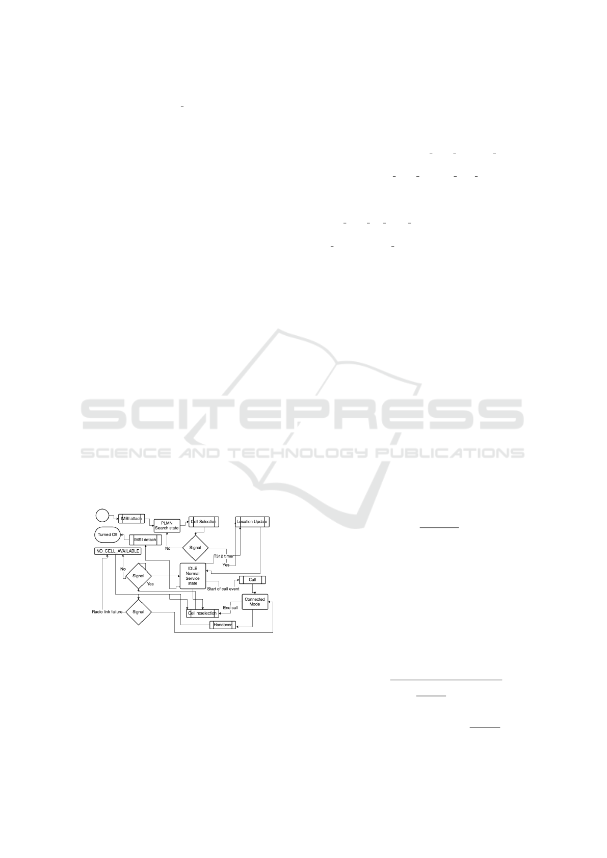
are illustrated in the Figure 2. Mobility management
has a reference to the mobile device to call out mo-
bility related procedures from the lower layers. Then,
there are mobility management state related variables;
the T312 timer is for reminding a mobile device to
make periodic location updates after every user de-
fined steps (by default 10 steps). Some state rela-
ted extra scenarios, define whether the mobile has
been turned on, the SIM card inserted, the IMSI at-
tached, and define whether the mobile has PLMN re-
lated information. In the Figure 2 a mobile mobi-
lity life cycle is described visually for better under-
standing. At the start of the mobility management
Figure 2: The simple work flow of the mobility manage-
ment.
update, the creation of the current time step’s mo-
bility events for the simulation for this specific de-
vice takes place. During the mobility management
update event, there will be a call out to the mana-
gement cores update function which increments in-
stantly the periodic location update with respect to
the previous state that goes through state machine
to determine the next steps: a) If the mobility ma-
nagement state is classified as NULL the core up-
date will change mobile to the state as it was just
physically turned on; b) MM IDLE NORMAL SERVICE
starts mobile cell selection method on the de-
vice level.c) MM IDLE SEARCH FOR PLMN starts
mobile cell selection method, but since the de-
vice has never been connected to the network, it
also waits for the surrounding PLMN information;
d) MM IDLE NO CELL FOUND start mobile cell se-
lection, since there is currently no connectivity; e)
MM CONNECTION ACTIVE starts the cell selection
process for the handover purposes, if needed.After
cell selection, the work-flow will move from the de-
vice back into the mobility management, where the
state of MM will be updated and location update ini-
tiated. If the state machine has done its work, then
there is a successive check to determine if the periodic
update is needed and, if it is, then it will be executed.
The rule with the periodic location update is that if a
mobile has not had any location updates during some
certain amount of simulation steps, then the mobility
management has to step in and remind the transmit-
ter that it still exists and has not been lost during the
commute.
5.3 Wave Propagation
During the cell selection, the mobile device has mul-
tiple challenges. It has to determine the nearest poly-
gons, determine in which one of them it resides, and
determine the signal strength from the base stations
transmitter. The signal strength has been envisioned
by the free space wave propagation model:
P
r
(d) =
P
t
G
t
G
r
λ
2
(4π)
2
d
2
L
, (1)
Where P
r
(d) is the received power, P
t
is the transmit-
ter output power, G
t
is transmitter gain G
r
is antenna
gain, d is the distance between the MS and the to-
wer, and L is the system loss factor. (Nishith Tripathi,
2014). This latter indicates the power received by the
antenna under ideal conditions. in addition, the free
space model predicts the powers decay to be the ne-
gative square root of the distance. In our case, we
have not included the system loss factor. Besides, the
distance in the equation 1 is calculated between the
tower and the vehicle based on Haversine distance:
d = 2r Arcsin
s
sin
2
φ
2
− φ
1
2
+ f (φ
1
, φ
2
)
!
f (φ
1
, φ
2
) = cos(φ
1
)cos(φ
2
)sin
2
λ
2
− λ
1
2
,
(2)
VEHITS 2018 - 4th International Conference on Vehicle Technology and Intelligent Transport Systems
586

where φ is the latitude, λ the longitude and r is the
Earth’s radius in meters (6 371 000 meters).
During the signal strength calculation, we use
the configuration supplied tower transmitter output
strength (dBm) and the transmitter’s frequency. From
the frequency, we calculate the wavelength. Wave-
length equals the speed of light divided by the trans-
mitter emitted frequency.
5.4 Location Update, Cell Selection and
Reselection, Handover
The procedures are key component of keeping track
of the mobility management level state, this can be
seen also in the Figure 2.
Cell selection is a mobile device level method for me-
asuring the current signal strength value of the serving
antenna and manage handover procedure. During the
(a) The example of R-
tree after all the shapes
have been inserted into
the tree.
(b) The R-tree visualized as a
diagram
Figure 3: Overview of R-tree process.
cell selection, the first step is to find surrounding cel-
lular network cells. Those cells (polygons) are struc-
tured into the R-tree entity during the creation of the
mobility tower control unit, where they were added
for a faster search, as illustrated in the Figures 3(a)
and 3(b), R-tree is a tree data structure to handle spa-
tial data efficiently by indexing shapes for the future
access. (Guttman, 1984) After searching the nearest
polygons to the device, we check through the vector
of cells and determine whether the vehicle is in the
cell or not using the winding number algorithm. The
vehicle might be in multiple cells; therefore, we are
calculating the best signal strength and accordingly,
we pick the transmitter and cell to camp on. In es-
sence, the winding number algorithm is an algorithm
which counts the number of times the polygon winds
around the point of interest. If the point is not inside
of the polygon, then the resulting winding number is
0. (Kai Hormann, 2001) During the cell selection, the
registration to the tower or the deregistration from the
tower will be determined. This is emulating the regis-
tering the mobile devices location area into the visitor
location register. The final step is the status update of
the mobility management.
Location update is the mobility management level
procedure for updating the devices location in the net-
work. Location update resets the periodic update ti-
mer (sets the timer back to 0) and updates the mobi-
lity management state.
Handover procedure is triggered by the state machine
at the level of MM CONNECTION ACTIVE when there
is a better quality cell flagged true.
5.5 Mobility Events and the Simulation
Cycle
We have covered the mobility management tied
event object called MobilityManagementUpdate. In this
section, we will discuss the mobile device related
event. MobilityEvent extends the SUMO Command ab-
stract event base class. The mobility events have
their own MSEventControl container-event queue and
the events are being executed at the very end of the si-
mulation step, after the mobility management update
events. Each mobility event has a type, which is de-
clared in the enum of MobilityEventType in the class of
MSMobilityEventData. The event has the mobile device
reference to let the mobile know about the radio link
failure and trigger the log creation about the occur-
red event. Other attributes of the mobility event are
the events start time and end time. Calls and the web
communication events depend on the timeframe vari-
ables.
5.6 Mobility CDR-like Logs
Call detail record (CDR) is the information about in-
coming and outgoing mobile activities, e.g., calls or
SMS messages. The data in the CDR is about the
event originated and the terminated parties (both sides
phone numbers), time of connection through the star-
ting time and the call duration, call event type, unique
generated id for the record, etc. (Horak, 2008) Mobi-
lityLog class is a data structure that, emulates the es-
sence of CDR. The attributes of the mobile logs are
illustrated in Table 3 (also visible in the Figure 1):
6 RESULTS
The results are illustrated through the outcome of the
logs generated by the simulator. The figure 4 is re-
flecting the interactions between the mobile devices,
GPS devices and the cellular network.
6.1 GPS Logs
MSDevice GPS related logs can be created in two
ways: through main SUMO configuration file or
Introducing Cellular Network Layer into SUMO for Simulating Vehicular Mobile Devices’ Interactions in Urban Environment
587
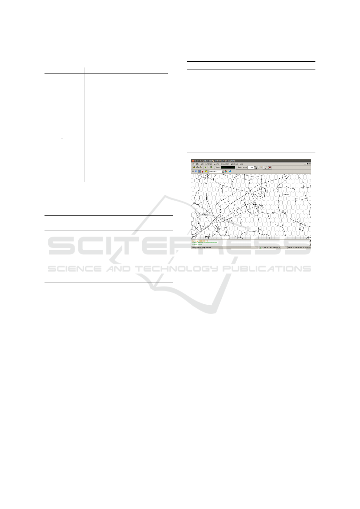
Table 3: Mobility Log Record Attributes.
Attribute Description
timestamp Amount of seconds since
simulation started
event type CALL INIT, CALL REC,
SMS SEND, SMS REC,
WEB COM, KEEP ALIVE
imsi subscriber ID
(vehicle ID)
cgi Common Gateway Identifier (CGI)
the transmitter id
(or simply a cell id)
signal strength radio signal strength
during the event
latitude latitude coordinate
(vehicle actual location)
longitude longitude coordinate
(vehicle actual location)
speed vehicle speed
during the event (in m/s)
through SUMO route file. Listing 2 illustrates the
GPS signal log, it contains timestamp, longitude, and
latitude.
Listing 2: GPS coordinates (longitude and latitude) with a
timestamp.
<gps-output>
<vehicle id="1">
<gps-device id="gps_1">
<signal time="1.00">
<coordinates latitude="58.29626476" longitude="26.44804043"/>
</signal>
<signal time="3.00">
<coordinates latitude="58.29628805" longitude="26.44810251"/>
</signal>
<signal time="5.00">
<coordinates latitude="58.29622327" longitude="26.44831755"/>
</signal>
</vehicle>
</gps-output>
6.2 Cellular Network Simulation Logs
The MSDevice Mobile class generates logs in case the
corresponding mobile device has configuration values
set to true, and the mobile data events have been ge-
nerated by MESGEN. In addition, the cellular network
coverage file (XML) should be specified. Otherwise
there would be no connectivity for the devices and the
events cannot occur.
The configuration of the mobile devices is similar
to the GPS devices. One must define the mobile de-
vice into the route file or one can set all the vehicles
to carry a mobile device in the SUMO configuration
file.
In the results, the cellular network behaviour si-
mulation written into XML file are illustrated in Lis-
ting 3. The logging entity is defined in the Fi-
gure 1 (class MobilityLog) and is explained in the
Section 5.6.
Listing 3: CDR-like mobility logs.
<mobile-output>
<vehicle id="1">
<event timestamp="92.00" eventType="KEEP_ALIVE"
imsi="1" cgi="t-438-1" signalStregnth="-21.01"
latitude="58.29" longitude="26.46292491"
speed="13.68143750"/>
<event timestamp="94.00"
eventType="SMS_REC"
imsi="1" cgi="t-438-1" signalStregnth="-21.70533381"
latitude="58.29089506" longitude="26.46336419"
speed="12.64468285"/>
</vehicle>
<vehicle id="27">
<event timestamp="27.00" eventType="CALL_INIT"
imsi="27" cgi="t-852-1" signalStregnth="-21.11894073"
latitude="58.25022813" longitude="26.43376626"
speed="0.00000000"/>
<event timestamp="28.00" eventType="CALL_INIT"
imsi="27" cgi="t-852-1" signalStregnth="-21.21370266"
latitude="58.25021502" longitude="26.43379995"
speed="2.45816080"/>
</vehicle>
</mobile-output>
Figure 4: 5G standard proposes use of micro-cells, there-
fore an example of HexagonGen generated micro-cells in
SUMO.
7 CONCLUSION
In this article, we are introducing a new layer into
SUMO simulator. Our layer simulates the cellular
network behavior and generates the logs of the inte-
ractions between the mobile devices and the mobile
network. In addition, in order to make the integra-
tion with SUMO we created two main components:
Mobility Event Simulation generator and mobile cell
coverage generator. The results of our simulator is a
set of mobile logs similar to CDR data that reflects
the communication and the interactions between the
vehicular mobile devices in the SUMO’s vehicles and
the cellular network. In general, the outcome is very
encouraging and there is many enhancements that can
be added; especially with in regards to the mobile net-
work model for reflecting the mobile network proto-
cols and behavior.
VEHITS 2018 - 4th International Conference on Vehicle Technology and Intelligent Transport Systems
588

ACKNOWLEDGEMENT
This research work was supported by IUT34-4 ”Data
Science Methods and Applications” (DSMA) project.
REFERENCES
Bolla, R. and Davoli, F. (2000). Road traffic estimation
from location tracking data in the mobile cellular net-
work. In Wireless Communications and Networking
Conference, 2000. WCNC. 2000 IEEE, volume 3, pa-
ges 1107–1112. IEEE.
Bulut, E. and Szymanski, B. K. (2013). Wifi access point
deployment for efficient mobile data offloading. ACM
SIGMOBILE Mobile Computing and Communicati-
ons Review, 17(1):71–78.
DLR (2017). DLR - Institute of Transportation Systems
- SUMO Simulation of Urban MObility. http://
www.dlr.de/ts/sumo. 2017-12-15.
Finkenzeller, K. and M
¨
uller, D. (2010). Rfid handbook:
fundamentals and applications in contactless smart
cards, radio frequency identification and near-field
communication. UK: John Wiley & Sons, Ltd.
Guttman, A. (1984). R-trees: A dynamic index structure for
spatial searching, volume 14. ACM.
Hadachi, A., Batrashev, O., Lind, A., Singer, G., and Vai-
nikko, E. (2014). Cell phone subscribers mobility
prediction using enhanced markov chain algorithm.
In Intelligent Vehicles Symposium Proceedings, 2014
IEEE, pages 1049–1054. IEEE.
Hadachi, A., Mousset, S., and Bensrhair, A. (2013). Ap-
proach to estimate travel time using sparsely sam-
pled gps data in urban networks. Electronics Letters,
49(15):957–958.
Horak, R. (2008). Telecommunications and Data Commu-
nications Handbook, 2nd Edition. Wiley.
Kai Hormann, A. A. (2001). The point in polygon pro-
blem for arbitrary polygons. Computational Geome-
try, 20(3):131–144.
Karnadi, F. K., Mo, Z. H., and Lan, K.-c. (2007). Rapid
generation of realistic mobility models for vanet. In
Wireless communications and networking conference,
2007. WCNC 2007. IEEE, pages 2506–2511. IEEE.
Kolici, V., Oda, T., Spaho, E., Barolli, L., Ikeda, M., and
Uchida, K. (2015). Performance evaluation of a vanet
simulation system using ns-3 and sumo. In Advanced
Information Networking and Applications Workshops
(WAINA), 2015 IEEE 29th International Conference
on, pages 348–353. IEEE.
Krajzewicz, D., Erdmann, J., Behrisch, M., and Bieker,
L. (2012). Recent development and applications of
sumo-simulation of urban mobility. International
Journal On Advances in Systems and Measurements,
5(3&4):128–138.
Lind, A., Hadachi, A., and Batrashev, O. (2017). A new
approach for mobile positioning using the cdr data of
cellular networks. In Models and Technologies for In-
telligent Transportation Systems (MT-ITS), 2017 5th
IEEE International Conference on, pages 315–320.
IEEE.
Nishith Tripathi, J. H. R. (2014). Cellular Communications:
A Comprehensive and Practical Guide. Wiley. 1032
pages.
ns 2 (2017). The Network Simulator - ns-2. https://
www.isi.edu/nsnam/ns/. 2017-12-15.
ns 3 (2017). ns-3. https://www.nsnam.org/. 2017-12-15.
OMNeT++ (2017). OMNeT++ Discrete Event Simulator -
Home. https://www.omnetpp.org/. 2017-12-15.
OSM (2017). OpenStreetMap. https://
www.openstreetmap.org. 2017-12-15.
Pan, B., Zheng, Y., Wilkie, D., and Shahabi, C. (2013).
Crowd sensing of traffic anomalies based on human
mobility and social media. In Proceedings of the
21st ACM SIGSPATIAL International Conference on
Advances in Geographic Information Systems, pages
344–353. ACM.
Piorkowski, M., Raya, M., Lugo, A. L., Papadimitratos, P.,
Grossglauser, M., and Hubaux, J.-P. (2008). Trans:
realistic joint traffic and network simulator for vanets.
ACM SIGMOBILE mobile computing and communi-
cations review, 12(1):31–33.
Sommer, C., Yao, Z., German, R., and Dressler, F. (2008).
On the need for bidirectional coupling of road traffic
microsimulation and network simulation. In Procee-
dings of the 1st ACM SIGMOBILE workshop on Mo-
bility models, pages 41–48. ACM.
Statista (2017). Number of mobile phone users worldwide
from 2013 to 2019. https:// www.statista.com/
statistics/274774/forecast-of-mobile-phone-users-
worldwide/. 2017-12-15.
Wedel, J. W., Sch
¨
unemann, B., and Radusch, I. (2009).
V2x-based traffic congestion recognition and avoi-
dance. In Pervasive Systems, Algorithms, and Net-
works (ISPAN), 2009 10th International Symposium
on, pages 637–641. IEEE.
Zaldivar, J., Calafate, C. T., Cano, J. C., and Manzoni,
P. (2011). Providing accident detection in vehi-
cular networks through obd-ii devices and android-
based smartphones. In Local Computer Networks
(LCN), 2011 IEEE 36th Conference on, pages 813–
819. IEEE.
Introducing Cellular Network Layer into SUMO for Simulating Vehicular Mobile Devices’ Interactions in Urban Environment
589
