
Knowledge Discovery for Interactive Dialogue Management with
Geoinformation Service
Stanislav Belyakov, Alexandr Bozhenyuk, Marina Belyakova and Sergey Zubkov
Institute of Computer Technologies and Information Security, South Federal University, Chekhov St. 2, Taganrog, Russia
Keywords: Knowledge Discovery, Visualization of Spatial Data, Geographic Information Systems, Intelligent Systems,
Adaptation.
Abstract: The problem of adaptation of the geoinformation service to the increasing amount of knowledge and
modification of the spatial database structure is analyzed in this article. The necessity to take into account
the factors of changes in information basis is considered by a visualization of searching procedure and by
analyzing spatial data of the geoinformation service. The paper proposes a method for solving the problem,
based on the principle of the evolution of technical systems. In this problem the evolutionary principle
considers the continuous rules generation procedure by the geoinformation service containing knowledge of
useful cartographic objects for visual analysis. The rules are considered as hypotheses that require collective
confirmation from the clients of the service. Confirmation of any rule is a selection of useful knowledge for
further implementation. Thus, the proposed mechanism provides a continuous adaptation to a changing
information environment through the development and rule selection. The mechanism of generation is
analyzed and the structure of rules is determined. The mechanism of collective confirmation of rules is
considered as well.
1 INTRODUCTION
Network geoinformation services are systems for the
collective use of spatial data. The geoservice
information database includes charts, maps, plans,
earth surface photographs and other materials that
reflect real-world phenomena and objects (Shashi
and Hui, 2008). Depending on the field of
application, geoservices have different sizes - from
corporate to geoservices in Internet (Brimicombe
and Chao, 2009). Geoservice of any size (scale) can
be attributed to BigData systems . This feature is
determined by the (appointment of any geographic
information system, which consists in the continuous
accumulation of data on the changing world around.
The volume of spatial data is constantly growing,
existing structures and their representations are
changing (Yang at al., 2015), and new structures are
emerging. Spatial data never become obsolete, only
the relevance is changed with regard to the solution
of specific applied problems. The use of spatial data
is impossible without a set of special methods aimed
at obtaining information useful for the solution of
the problem. It is of great interest to develop some
methods that can be used for visual representation
and visual analysis of spatial data. Cartographic
visualization is the most effective tool for solving
complex informal problems. Software tools of
special types of analysis (statistical, topological,
morphological, network and many others) play an
auxiliary role. They complement the virtual
cartographic image that the map analyst develops
(Belyakov et al., 2014).
The selection of useful information largely
determines the final result of spatial data usage. In
accordance with the principles of cartographic
research (Shashi and Hui, 2008) the user should
build a workspace of the geoservice information
base. The workspace includes cartographic objects
that are grouped into thematic layers and linked by
links to external databases. The problem complexity
of constructing a workspace is to select useful data
from the BigData source. This source is the
geospatial database. Unsatisfactory implementation
of this problem entails losses caused by the adoption
of inadequate decisions.
Let's consider a simple example. When planning
the placement of a vending machine on the territory
of a residential complex, the analyst is looking for
cartographic data that to help evaluate the
Belyakov, S., Bozhenyuk, A., Belyakova, M. and Zubkov, S.
Knowledge Discovery for Interactive Dialogue Management with Geoinformation Service.
DOI: 10.5220/0006836504350442
In Proceedings of 8th International Conference on Simulation and Modeling Methodologies, Technologies and Applications (SIMULTECH 2018), pages 435-442
ISBN: 978-989-758-323-0
Copyright © 2018 by SCITEPRESS – Science and Technology Publications, Lda. All rights reserved
435
effectiveness of the decision. The intensity of the
flow of people passing by the machines, the
approximate share of potential buyers, the relative
position of objects or phenomena, the size of the
access zone for maintenance of the machine, the
logistics capabilities of the placement point from the
perspective of further business development have a
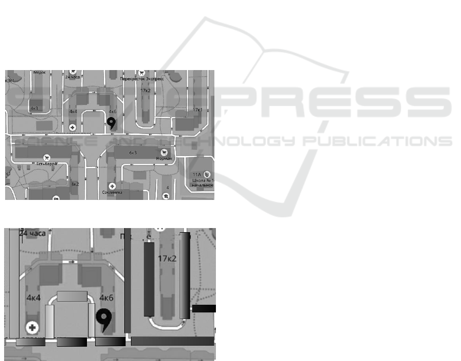
complex effect on the efficiency of choice. In Fig. 1
shows the section of the working area of the
analysis, which was formed on the basis of
experience in solving the type of problems under
consideration. The selected position of the vending
machine is marked with the special sign. In Fig. 2
shows the important elements for analysis, which
one of the analysts used to construct the solution.
These elements are data on the density of cars in
parking lots along highways. Since a number of
standing cars greatly reduces the visibility of the
vending machine by nearby people, this decision
may be erroneous. Analyzing this example, you can
see a potential opportunity to improve the quality of
geoservice: one of its users found useful data, which,
perhaps, can be successfully used by other analysts
who solve similar tasks.
Figure 1: Example of the working area.
Figure 2: The important elements for analysis.
In this paper, an approach based on knowledge
discovery is analyzed to improve the efficiency of
visual analysis of maps and charts in an interactive
mode of working with geoservice.
2 APPROACHES OVERVIEW
There are several approaches to solving the problem
of selecting spatial data useful for analysis. The
main idea of each approach is a special concept
definition for the search and use of knowledge,
which improves the quality of visual analysis of
geodata.
The methodology of traditional cartographic
research (Shashi and Hui, 2008) assumes the
creation of a thematic map for solving a certain class
of applied problems. The professional knowledge
and experience of the cartographer, as well as
fundamental knowledge of cartography, play a
decisive role in this case. The search and
generalization of maps of different subjects have a
pronounced creative character. The result is unique
cartographic works. The nature of this activity is
very different from the procedures for searching and
analyzing maps for solving specific applications.
Therefore, the methodology adopted in the field of
the search for and use of knowledge cannot be
directly used.
Works on geo-visual analytics (Andrienko et al.,
2013) examine the mechanisms for the formation of
new cartographic representations that are adequate
to the goals of analysis. The significance of a new
view is determined by new knowledge and patterns
that the analyst can identify. Software tools play an
important role in scaling, aggregating and
summarizing cartographic images. It can be
concluded that the selection of abstractions and the
development of tools for visual analysis of the
generated image form the basis of the approach
under consideration. So it is possible to obtain
practically important conclusions and dependences (
Andrienko and Andrienko, 2016). At the same time,
manipulating the cartographic image for presentation
system is a more general process. Perception of
images by the user plays a decisive role in any way
of displaying. The problem of reducing the utility of
cartographic visualization with its complication in
the work of this direction is not considered.
Neo-cartography (Faby and Koch, 2010) aims to
display the surrounding world in real time. This
approach is focused on presenting the real world
with multimedia data. The user interface is
intentionally simplified, which is important for
geoinformation Internet services. A particular
feature of this approach is the weakening of the
SIMULTECH 2018 - 8th International Conference on Simulation and Modeling Methodologies, Technologies and Applications
436

connection with such important mechanisms for the
synthesis of cartographic images as cartographic
classification and generalization. Accordingly,
interactive interaction has a specific semantic
orientation, which makes it difficult to use the
regularities of dialogue in traditionally constructed
geoservices.
Research in the field of intellectual visualization
(Pettit et al., 2008; Malczewski, 2004; Keim, 2002)
aims to create procedures for the selection of useful
information. As the analysis has shown, this problem
is solved by the creation of complete ready-to-use
information resources. At the same time, the
problem of identifying knowledge remains little
explored for constructing universal mechanisms for
selection of thematic data in local areas of spatial
databases.
The idea of collective usage of spatial data is
studied in the framework of the direction of the
creation of the Global Spatial Data Infrastructure (Li
et al., 2012; Wang 2010). Here the main attention is
paid to the technology of sharing spatial data and
servicing the BigData data storage system. At the
same time, the problems of discovering the patterns
of using information in a dynamic database
structure, the collective experience of rational
selection of data remain outside the scope of
research.
The research direction related to ensuring the
quality of geodata, covering all stages of obtaining
and using spatial data, is, from our point of view, the
most promising (Hart and Dolbear, 2013; Ali and
Schmid, 2014; Goodchild and Li, 2012; Fairbairn,
2015). Identifying and using knowledge to manage
the quality of workspaces and solving application
classes (Popovich et al., 2011) is an important but
insufficiently studied problem.
The following works (Lughofer, 2011; Angelov,
Filev and Kasabov, 2010; Angelov, 2012) are
devoted to developing (evolving) systems. The
mechanism of evolution suggests the accumulation
of knowledge in real-time and automatic learning.
This direction of building systems allows to realize
autonomous adaptation to changing external
conditions. The results of studies deal with the
processing of numerical data streams and fuzzy rules
of classification. It seems appropriate to extend this
mechanism to the process of dialogue between
clients and geoservice.
3 THE PRINCIPLE OF
OPERATION GEOSERVICE
Geoservice is an intelligent information system that
serves analyst users through software clients. Clients
realize the functions of visualization of cartographic
data obtained at the request of geoservice. The
database of cartographic data and knowledge is
stored on the server.
Consider in general the task of optimizing the
dialogue that geoservice decides. Let
},...,{
21 n
be the set of cartographic objects
of the spatial database, and
w
is the workspace
of the map created by the user to find the solution to
the applied task. The complexity of the workspace
(the number of cartographic objects in it) is usually
much less than the complexity of the service
database:
.|||| w
This ratio is achieved as a result of the user
performing a sufficiently large amount of work on
the selection of useful information. The reason for
this is a significant redundancy in the spatial data
stream generated by spatial queries (Shashi and Hui,
2008).
We denote by
)(wI
the utility function of the
workspace and by
n
qqq ,...,
21
- the sequence of the
software client's requests to the geoservice. Then
geoservice must solve the problem:
j
j
r
i
i
q
EB
EBw
w
wI
,,
,
,
max,)(
(1)
here
i
q
is the set of cartographic objects
received by the software client on request of
i
q
;
j
r
is a set of cartographic objects selected
according to the
j
r
rule from the geoservice
knowledge base of the
),( BR
. The
B
(workspace
skeleton) set is a set of objects formed by the server
at the client's request, and the
E
set is the set of
objects that are the semantic addition of the skeleton.
),( BRr
j
rules define those cartographic objects
that are selected from the spatial database and are
entered into a workspace built from a number of
cartographic objects of the skeleton
B
. Knowledge
Knowledge Discovery for Interactive Dialogue Management with Geoinformation Service
437

can be applied to an arbitrary set of objects. The
result will be an image of reality in the context of the
knowledge used. It should be noted that the utility
)(wI
of the workspace is changed by varying the
environment. For example, a car route constructed
on request is presented in different ways in the
context of transport of people or large-sized cargoes.
As shown in (Belyakov et al., 2014), the solution
of the utility maximization problem is to find the
classes, objects and relations that make up the set of
the environment
E
, and specify a preference
relation that allows us to establish a non-strict order
on the set of its elements.
It should be noted that
),( BR
contains
fundamental knowledge for solving an applied
problem. This knowledge is distinguished by a high
level of generalization and, for obvious reasons,
does not take into account local factors important for
mapping in specific contexts. For example, when
implementing a logistics project, it is natural to
display on the map a transport highway with the
points of loading and unloading the vehicle.
However, in some parts of the locality at certain
times of the year, unfavorable weather conditions
may occur. This will require knowledge of
additional parking spaces, transshipment or
repackaging of cargo.
Lack of special knowledge is an objective
property of the geoservice knowledge base. This
property will be preserved, despite any attempts to
achieve completeness. The reason is the variability
of the real world. In order to compensate for the
incompleteness, it is proposed to use the possibility
of temporarily disabling the intellectual support of
the dialog in the normal operation of the service.
This will allow the analyst to block "unreasonable"
from his point of view the behavior of the system, as
well as to indicate periods of use by the analyst of
their own knowledge that improve the quality of the
work area.
Geoservice, which solves problem (1), works as
follows:
software client establishes a connection to the
server, having agreed the context. This
determines the rules for creating the most
useful images according to the user's
professional identity. It is believed that the
system has a description of sets of rules for
several contexts. The default context is
specified when the user logs on. The context
does not change in the session, however, with
the geoservice, the same user can set an
arbitrary number of sessions;
user-analyst sends
n
qqq ,...,
21
queries, forming
the skeleton
B
of the workspace. The
skeleton environment is built on the server
side by applying the
),( BR
knowledge base
rules. The rules implement a reasonable
strategy for building the most useful
workspace. After processing each request, the
server evaluates the utility
)(wI
by changing
the composition and number of environment
objects so as to maximize the utility level;
on the client side, the analyst uses visualization
tools that are wrappers for standard scaling,
panning, ang and views. Each wrapper uses
the knowledge of the service to display the
required portion of the workspace of the map.
Intelligent selection of environment objects
precedes the standard rendering operation;
analyst has the ability to disable and re-enable
intelligent geoservice support at any one time.
Disabling means that the application of the
),( BR
rules is blocked. After that, the
analyst continues to study and modify the
workspace manually. The subsequent
inclusion of intellectual support leads to the
reorganization of the workspace: the created
skeleton is provided with a newly constructed
environment;
session end means either the end of the work
with the geoservice, or the transition to a new
context of visual analysis. In the latter case,
the skeleton of the completed session is saved.
A new session represents the workspace in a
new context by constructing the corresponding
environment.
Analyzing the principle of geoservice, the
following problems should be noted. The quality of
the solution of the problem (1) is determined by the
knowledge of
),( BR
about the objects, classes
and relationships of the
spatial database. If the
structure is modified, i.e. there are previously
unknown classes and instances of objects and
relations, the management of the dialog is losing its
effectiveness for two reasons. First, any new classes
of objects and relations between them are absent as
facts or rules of the knowledge base. Consequently,
their re-use in subsequent sessions is impossible.
Workspaces of analysis lose their quality due to the
lack of relevant data. Secondly, there is an objective
process of "obsolescence" of knowledge about the
dialogue. The classes and instances of objects used
for a certain period of time lose their significance
and are interpreted as redundant. Since geoservices
never delete the accumulated data (Shashi and Hui,
SIMULTECH 2018 - 8th International Conference on Simulation and Modeling Methodologies, Technologies and Applications
438

2008), the work areas are becoming increasingly
redundant. Thirdly, the growth in the number of
objects of known classes makes it increasingly
difficult to select the most useful of them. Additional
knowledge is required for an adequate selection of
the most significant objects.
4 KNOWLEDGE DISCOVERY
PROBLEM DEFINITION
Knowledge in the task of managing of interactive
interaction is understood as information that allows
the geoservice to efficiently select useful data into
the workspace of the analysis. The geoserver in this
case is considered as an evolving system (Angelov,
2012), which accumulates data in real time and self-
learning.
The main source of knowledge is the work area,
which is built by an analyst without intellectual
support of geoservice. What can force a user to
temporarily abandon it? Analysis shows that there
can be three reasons.
The first reason is that geoservice does not use
objects and relationships that are important from the
point of view of the analyst. The information deficit
is replenished by the analyst manually, and this must
be done repeatedly in each session.
The second reason is connected with filling the
work area with insignificant objects, which leads to
an increase in redundancy. This leads to
deterioration in the perception of the cartographic
image, and to an increase in the laboriousness of
manipulating the image in the process of its study.
The third reason is the unsatisfactory work
function of changing the complexity of the
workspace. As mentioned above, this function is an
analog of the known scaling and panning functions
with the only difference that when you execute
them, the composition of the objects of the
workspace changes. This is done to preserve its
logical consistency. The unsatisfactory work of the
function in question is that its integrity is violated.
A manually constructed fragment is a source of
knowledge about the usefulness of a cartographic
image. Obvious is the subjectivity of this
knowledge, its ontological uncertainty and the
vagueness of the evaluation of the actual material.
For this reason, the following approach is proposed:
at the moment when the intellectual support of the
interactive dialogue is disconnected, fix the
manually constructed work area, then, based on the
analysis of the composition of the selected objects,
generate product rules, and then evaluate their
utility. Utility is confirmed by the repeated use of
rules by users of the service.
5 RULES GENERATION
PROCEDURE
The
),( BK
rules display knowledge of how the
work area boundaries (
w
) are defined for a given
skeleton
B
and the objects selected for analysis are
ranked by significance. Order on a set of
workspace objects is used to display the most
important elements of the image when zooming and
panning. Accordingly, it is possible the generation of
several types of rules.
The rules for determining the spatial boundary
have the form:
IF Properties (Object) Corresponds Sample
THEN BufferRadius = Value.
Here, the Correspond relation establishes a way
to map the attributes of the object selected by the
Property (x) function to the reference value. The
variable BufferRadius is used to build a spatial
buffer for a given object. The construction of the
buffer zone is a standard analytical function of
geoinformation systems (Shashi and Hui, 2008),
which consists in constructing the convex hull of a
set of geometric primitives at a given distance (of a
given radius). The buffer zones of individual objects
are combined into a single buffer zone of the
skeleton
B
. An example of such a rule may be:
IF TypeOfObject (ObjectID) = “Road” THEN
BufferRadius = 40,
where TypeOfObject (x) function determines the
type of the object by its identifier.
The rules for determining the temporary border
are presented in a similar way:
IF Properties (Object) Corresponds Sample
THEN Interval = Value.
Here, the variable Interval indicates a deviation
relative to the set base point of time. This point, like
the spatial coordinates of the analyzed area on the
map, can change in the course of work.
The rules for defining semantic boundaries are of
the form:
Knowledge Discovery for Interactive Dialogue Management with Geoinformation Service
439

IF Properties (Object) Corresponds Sample
THEN AddToList (BorderElement).
The AddToList(x) function adds instances of
objects and relationships to the list that forms the
semantic boundary of the workspace.
A spatio-temporal query to the geoservice
database can be constructed from the result of
applying the rules to skeleton
B
at any one time.
The result of which is the addition to the skeleton of
the environment
E
.
Rules of preference on the set of objects of the
workspace have the form:
IF Properties (Object1) Corresponds Sample1
AND Properties (Object2) Corresponds Sample2
THEN Object1 ComparisonOperator Object2.
By the designation ComparisonOperator is
meant a possible variant of comparison - "more
preferable", "less preferred", etc.
The above rules are used to describe the
precedents of constructing the shell of the
workspace. To evolve knowledge from individual
facts to generalizations, rules of another type must
be generated. The structure of these rules is
determined by the logic of using cartographic
information. Consider the following operations for
generating rules: aggregation, generalization and
transposition.
An aggregation of rules will be called an
operation that leads to a new rule from several
existing rules, which involves performing in some
way all the actions of the original rules:
),,...,,(
21 kа
RRRAR
where A is the aggregation operator. An example
of aggregation may be the disjunction of antecedents
and the conjunction of the consequent of the original
rules. The aggregating rule
а
R
is entered in the
knowledge base, and rules
k
RRR ,...,,
21
are deleted.
The aggregation result is not reliable, but it looks
plausible. A prerequisite for constructing an
aggregating rule is the following:
,
,1,
kji
j
R
i
R
ww
where
i
R
w
is the workspace in which
i
R
rule
was previously built. In accordance with this
condition, the aggregating rule
а
R
can be generated
only for space-time and semantic areas that have
"something in common".
The generalization of
m
RRR ,...,,
21
rule set
involves the construction of a general rule
),,...,
2
,
1
(
m
RRRGRg
where G is the generalization operator. As in the
previous case, only the
Rg
rule remains in the
knowledge base. Generalization also does not
provide reliable knowledge, although it may turn out
to be plausible. Unlike aggregation, generalization
implies the existence of a correspondence between
the objects of electronic maps of different levels of
generalization. Thus, availability of ready maps of
various levels of generalization is mandatory.
The transfer of experience between different
work areas (transposition of rules) is based on a
logical analogy. The operation of constructing
i
R
~
rule similar to the previously generated
i
R
rule
consists in applying the similarity operator
).(
~
ii
RLR
This operator implements the principles of
geographical classification of territories. An
example is the proximity of the workspaces by
geographical indicator - the relief or geophysical
structure. The transfer of experience consists in the
transformation of antecedent objects and consequent
of the chosen rule into objects of another workspace.
The operation of transferring experience is
unreliable, but plausible.
6 CONFIRMATION OF RULES
The generation methods considered above give only
hypotheses that require confirmation of their
usefulness. The task of selecting useful rules is to
evaluate the reliability of the generated rules and
exclude unreliable (useless) rules from the
knowledge base of the service. The criterion of
reliability is the degree of collective recognition of
the usefulness of the rule by users of the geoservice
for a limited time. The time factor is necessary for
the following reasons:
time imitates the "aging" of knowledge. There
is aging information on how to use spatial
data, in contrast to spatial data itself. The
objects and relationships used to solve the
same problem change for many reasons over
time;
time pragmatically limits the usefulness of the
rules to "the present time". Geoservice does
not set out to develop fundamental rules, with
SIMULTECH 2018 - 8th International Conference on Simulation and Modeling Methodologies, Technologies and Applications
440

a value independent of time. Priority is given
to locality and efficiency of knowledge;
cartographic production regulates the regulatory
periods for updating maps, schemes and plans.
There is no such requirement with respect to
the knowledge base. This means that
periodically there is an objective need to
develop new knowledge, which should ensure
the adaptation of the service to the updated
cartographic basis.
On this basis, pair
*)*,( nT
, in which
*T
is the
duration of the confirmation time interval, and
*n
is
the number of confirmations, should be considered a
measure of the confidence of the user service team
in the usefulness of the rules. The rule is considered
to be confirmed if, within the time
*Tt
from the
moment of the rule's appearance,
*nn
precedents
of its successful use are fixed. If at least one of the
formulated conditions is violated, the rule is
removed from the geoservice knowledge base.
Analyzing the proposed measure, it is necessary
to note the following:
1) there is a high probability that collectively a
useless rule will be confirmed for small
*n
values.
This is explained both by the psychology of user
behaviour (the ability to tolerate "inconvenience")
and the content of the workspace (in the area under
investigation, the rules may appear weak). The
probability under consideration decreases with
increasing
*n
, and for large values, confirmation of
useless rules becomes impossible;
2) small values
*T
lead to discarding useful
rules. The reason for this may be insufficient
intensity of geoservice use as a whole, or low
activity of analysts' work with separate areas.
Increasing the value of
*T
reduces the probability
of losing useful knowledge;
3) The limiting factor for values
*T
and
*n
values is the server performance. To identify and
verify knowledge, a fixed proportion of productivity
is assigned, which can be represented as the speed of
confirmation of rules
V
. The values of the pair
*)*,( nT
cannot be chosen uniquely
because
*/* TnV
.
It should be noted that speed of information
distribution in the social network can be used as a
limit to the rate of confirmation of the rules. At
present, there are a number of works devoted to
mathematical models of information dissemination
and the influence of users of social networks on each
other (Isea and Mayo-García, 2015). Analysts-users
of geoservice in many cases form professionally
oriented communities that have all the attributes of a
social network, which allows obtaining numerical
values of the rate of distribution of rules.
Note also that the number of
*n
confirmations
accumulates as a result of the summation of not
necessarily integers. As mentioned above, the
k
R
rule is confirmed if it is used to form the
environment (
E
) of the current
w
work area and
the user-analyst does not disable intelligent
geoservice support. Since each rule has a spatio-
temporal and semantic binding of
k
R
w
obtained at
the time of generation, the confirmation should be
estimated by the value:
.||/|| wwwn
k
R
Here,
|| x
denotes the power of a set of
cartographic objects in the region
x
.
If the rule is not confirmed, the total number of
confirmations is subtracted from the value
||/||
k
R
k
R
wwwn
.
The above relations take into account the fact
that the scope of each generated rule is limited.
7 CONCLUSION
The considered mechanism of using spatial data by
geoservice gives an effect due to the spread of the
experience of constructing workspaces for visual
analysis. The mechanism is based on knowledge of
the utility of individual objects and relationships
subjectively identified by users. Due to this, the
quality of information content of workspaces is
increasing and the quality of decisions taken on the
basis of spatial data is improved.
The advantage of the described principle is the
exclusion of the rigid dependence of the operation of
the geoservice software components on the structure
of the spatial database. Traditionally, all the
possibilities of forming workspaces are determined
by the database schema. To use new information
objects, you need to publish their description and
modify the software components. The principles of
using knowledge about new information objects
considered in this paper are not limited to a specific
database schema.
The experience of users, fixed by the rules, is of
great importance in the process of geoservice
adaptation to changing the structure of the
information environment. Consequently, the quality
of geoservice work depends heavily on the activity
Knowledge Discovery for Interactive Dialogue Management with Geoinformation Service
441

of users in the search and use of data. In this paper,
we propose the operation of generating hypotheses
based on existing rules to reduce this dependence.
Even with a small experimentally confirmed
material, many hypotheses can be constructed,
which will then be tested by experiment.
Evaluating the effect of the proposed approach,
we should pay attention to reducing the collective
costs of finding useful information. It is known that
the complexity of searching among N objects at best
requires O(logN) operations. Such costs in the case
of individual work are inevitable and are summed up
for all users of the geoservice. When you reuse an
element already found, the complexity is O(1),
which for the user community gives a significant
gain.
Further research can focus on the generalization
and transfer of the evolutionary principle to network
services of another purpose.
ACKNOWLEDGEMENTS
This work has been supported by the Ministry of
Education and Science of the Russian Federation
under Project 2.918.2017.
REFERENCES
Ali, A.L., Schmid, F., 2014 Data Quality Assurance for
Volunteered Geographic Information. In Geographic
Information Science Lecture Notes in Computer
Science, 8728, pp. 126-141.
Andrienko, G., Andrienko, N., Bak, P., Keim, D., Wrobel,
S., 2013. Visual Analytics of Movement. Springer-
Verlag. Berlin.
Andrienko, G., Andrienko, N., Rinzivillo, S., 2016.
Leveraging Spatial Abstraction in Traffic Analysis and
Forecasting with Visual Analytics. Information
Systems,57, pp. 172–194.
Angelov, D., Filev P., Kasabov, N., 2010. Evolving
Intelligent Systems: Methodology and Applications.
John Wiley & Sons.
Angelov, P., 2012 Autonomous Learning Systems: From
Data Streams to Knowledge in Real-time. John Wiley
& Sons.
Belyakov, S. L., Bozhenyuk, A. V., Belykova, M. L.,
Rozenberg, I. N., 2014. Model Of Intellectual
Visualization Of Geoinformation Service. In
Proceedings 28th European Conference on Modelling
and Simulation ECMS 2014, pp.326-332.
Brimicombe, A., Chao L., 2009. Location-Based Services
and Geo-Information Engineering. John Wiley &
Sons.
Faby, H., Koch, A., 2010. From maps to neo-cartography.
In 3rd International Conference On Cartography and
GIS. pp. 86-91.
Fairbairn, D., 2015 Mapping Disorder: An Exploratory
Study. Modern Trends in Cartography. In Lecture
Notes in Geoinformation and Cartography, pp. 13-22.
Goodchild, M. F., Li, L., 2012 Assuring the quality of
volunteered geographic information. In Spatial
Statistics, 1, pp.110-120.
Hart, G., Dolbear, C., 2013. Linked Data: A Geographic
Perspective. Taylor & Francis.
Isea, R., Mayo-García, R., 2015 Mathematical analysis of
the spreading of a rumor among different subgroups of
spreaders. In Pure and Applied Mathematics Letters,
2015, pp 50-54.
Keim, D.A., 2002 Information visualization and visual
data mining. In IEEE Transactions on Visualization
and Computer Graphics, 8, pp. 1-8.
Li, W., Linna, L., Goodchild M.F., Anselin, L., 2012. A
geospatial cyberinfrastructure for urban economic
analysis and spatial decision-making. In ISPRS
International Journal of Geo-Information, 2, pp. 413–
431.
Lughofer, E., 2011. Evolving Fuzzy Systems.
Methodologies, Advanced Concepts and Applications.
Springer Science & Business Media.
Malczewski, J., 2004. GIS-based land-use suitability
analysis: a critical overview. In Progress in Planning,
62. pp. 3–65.
Pettit, C., Cartwright W., Bishop, I., Lowell, K., Puller,
D., Duncan, D., 2008. Landscape Analysis and
Visualisation, Spatial Models for Natural Resource
Management and Planning. Springer-Verlag, Berlin.
Popovich, V., Vanurin, S., Kokh, S., Kuzyonny, V., 2011.
Intellectual Geographic Information System for
navigation safety. In IEEE Aerospace and Electronic
Systems Magazine, 26, pp.29-31.
Shashi, S., Hui, X., 2008. Encyclopedia of GIS.
SpringerScience+Buisiness Media, LLC. New York.
Wang, S., 2010. A cyberGIS framework for the synthesis
of cyberinfrastructure, GIS, and spatial analysis. In
Annals of the Association of American Geographers,
100, pp.535-557.
Yang, C., Sun, M., Liu, K., Huang, Q., Li, Z., Gui,
Z., Yunfeng, J., Xia, J., Yu, M., Xu, C., Lostritto, P.,
Zhou N., 2015. Contemporary Computing
Technologies for Processing Big Spatiotemporal Data.
In Space-Time Integration in Geography and
GIScience, pp. 327-351.
SIMULTECH 2018 - 8th International Conference on Simulation and Modeling Methodologies, Technologies and Applications
442
