
Optimization Design of Traffic Marking in Urban CBD Area
Mujie Lu
1
, Wei Wang
2
, Yuxuan Wang
3
and Jingyao Qu
4
School of Transportation, Southeast University, Nanjing, Jiangsu, 210096, China
1
mujielu_seu@163.com,
2
wangwei_transtar@163.com,
3
220162592@seu.edu.cn and
4
220162623@seu.edu.cn
Keywords: Central Business District (CBD), Three-dimensional Marking, CAD 3D Modeling, Traffic Safety.
Abstract: With the increasing proportion of motorized traffic in urban transportation, the conflict between slow traffic
and motorized traffic has become more and more serious, which is especially prominent in urban CBD area.
This paper proposes the solution to the three-dimensional optimization of the deceleration marking and the
guidance marking, innovatively puts forward using CAD 3D modeling to design the shape and dimension of
traffic markings. By analyzing the human visual perception and visual illusion principle, the design method
and basis of the three-dimensional marking are gradually obtained. Three-dimensional marking was applied
in Nanjing, Jiangsu Province. The practice shows that three-dimensional marking has been significantly
improved in reducing vehicle speed and the degree of deviation, which can ensure the safety and order of
traffic in CBD area.
1 INTRODUCTION
Road traffic safety is a worldwide problem, and
researches on traffic accidents have been paid more
and more attention by the government recently. As
the core of one city, CBD area has high density of
humans and vehicles. Although the speed of vehicles
is not too fast in CBD area, for the deceleration zone
with intertwined traffic flow, a speed of 40 km/h is
high enough to threaten pedestrians. At the same
time, intertwined vehicles are also prone to traffic
accidents, and one accident may bring congestions
to the entire CBD area.
Due to land shortages in urban CBD area, some
necessary management facilities have to be replaced
by traffic marking. However, some of the marking
did not play a good role. Because the right of way
for pedestrians was ignored, the crosswalk line,
originally considered to be the "secure line", has
become a kind of "dead line". On roads without
supervision, vehicles pass through the guidance
marking arbitrarily, which is easy to cause traffic
disorder. In addition, the noise problem caused by
the uplift deceleration belt is more and more
concerned by the public, so researches on the
three-dimensional marking based on driver's
psychological effect began to rise.
Through the study of road visual illusion and
human visual illusion, this paper finds out the
scientific and rational design method of
three-dimensional marking. The research team also
carried out three-dimensional optimization design
for the existing traffic marking in CBD area in order
to improve the ban, warning and indication effect of
the marking, and to promote the harmonious
development of the road transportation in CBD area.
2 DESIGN PRINCIPLES
2.1 Design Ideas
The main idea of this research is that the traffic
marking is designed into a seemingly 3D shape
based on the analysis of human visual perception
and visual illusion. The three-dimensional marking
can attract driver's attention easily using the illusion
of obstacles, so as to optimize the deceleration or
guidance effect of the traffic marking. However, the
nature of traffic marking is the two-dimensional
graphics set on the road, therefore, in order to make
the traffic marking simulate the 3D effect better, the
research needs to start from the driver's perspective,
making the three-dimensional graphics plane in
order to obtain the shape and dimension of the traffic
marking.
246
Lu, M., Wang, W., Wang, Y. and Qu, J.
Optimization Design of Traffic Marking in Urban CBD Area.
In 3rd International Conference on Electromechanical Control Technology and Transportation (ICECTT 2018), pages 246-251
ISBN: 978-989-758-312-4
Copyright © 2018 by SCITEPRESS – Science and Technology Publications, Lda. All rights reserved
2.2 Design Methods
2.2.1 Simulation of CAD Software
Open the 3D modeling window in AutoCAD
software and some feature parameters need to be
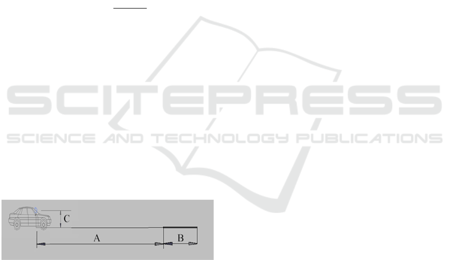
determined in the model firstly. As shown in Figure
1, the simulation of obstacles in front of the driver
requires three parameters, respectively:
A: The horizontal distance between the driver
and the front of road obstacle;
B: The dimensions of the road obstacle;
C: The vertical distance between the driver's line
of sight and the obstacle.
The horizontal distance between the driver and
the front of road obstacle shall not be less than the
safe braking distance of the vehicle, that is,
22
2
if
i
VV
ASVt
a
(1)
Where S refers to the safety braking distance, ܸ
refers to the initial velocity (the speed before
braking), t refers to the brake reaction time, ܸ
refers to the final velocity (safety speed), and a
refers to the deceleration of the vehicle. The
dimensions of the road obstacle should be selected
in conjunction with the shape of the existing
marking and the width of the road. The vertical
distance between the driver's line of sight and the
obstacle can be taken in accordance with the
relevant national standards. After selecting these
parameters, shapes of the obstacle saw by the driver
can be got by using camera preview functions in the
CAD software.
Figure 1 Simulation of road scene using CAD software.
2.2.2 Design of Marking Colors
Previous researches show that visual perception
provides about 80% of traffic information to the
driver, thus, visual perception is the most important
way for drivers to obtain outside information.
Colorfulness is one of the advantages of the
three-dimensional marking because people's feeling
for color is rapid and lasting. For three-dimensional
marking, the combination of colors should be
considered to make the overall effect better. Based
on the hue circle and the national standard of road
traffic sign and marking (GB-5768), and taking into
account the color matching effect of pavement and
marking, this research ultimately determines that the
color combinations of the three dimensional marking
are white, blue and yellow, and the specific color
scheme is determined by the shape of the marking.
3 RESEARCH CONTENTS
3.1 Investigation of CBD Traffic
Taking Xinjiekou, the CBD area of Nanjing, as an
example, the research team investigated the current
traffic organization in the CBD area and analyzed
the traffic organization problems according to the
survey data.
One investigation was conducted at an
unsignalized intersection in Zhongshan Road,
Xinjiekou area. The research team captured video to
record the situation of pedestrian crossing the street,
and used the handheld radar tachometer to record the
speed of vehicle through the crosswalk line.
According to statistical analysis, in the surveyed 165
motor vehicles, 72.1% of the vehicles have safety
speed which is below 30 km/h, but there are still
27.9% of the vehicles can reach the speed near 40
km/h or even higher.
Another investigation was conducted at the
intersection of Zhongshan Road and Dashiqiao
Street in Xinjiekou area, and there are guidance
markings for traffic channelization on the main road.
During the survey, it was found that when going
straight on the main road and turning right on the
secondary road were allowed at the same time,
vehicles will pass through the guidance marking
arbitrarily, there will be obvious traffic conflicts in
the diversion island so that influence the smooth
operation of the entire intersection.
In view of the above problems, this paper
proposes to realize the optimization of traffic
organization by using three-dimensional marking.
After the transformation, the three-dimensional
marking can achieve two optimization effects:
deceleration and guidance.
3.2 Design of Deceleration Marking
3.2.1 The Horizontal Distance between the
Driver and the Traffic Marking
Firstly, determine the brake reaction time. It includes
the response time of both the driver and the vehicle.
Optimization Design of Traffic Marking in Urban CBD Area
247
According to the results of previous studies, the
brake reaction time is about 0.5-0.6 seconds under
normal circumstances. Thus, in this paper, the value
of brake response time t is 0.5 s.
Secondly, determine the brake deceleration. For
ordinary passengers in the vehicle, when the brake
deceleration is less than 1.8 m/s
2
, people's feeling is
not so significant; when the deceleration reaches 3.6
m/s
2
, the feeling of people is obvious. Thus, in this
paper, the value of brake deceleration a is 1.8 m/s
2
.
Finally, determine the initial and final velocity of
the vehicle. It is considered to be high speed when
vehicles can reach the speed of 40 km/h in CBD area,
and relevant statistics show that when the collision
speed is 30 km/h, the pedestrian mortality rate is less
than 5%, but when the collision speed is 40 km/h,
the rate is up to 45%. Thus, in this paper, the value
of the initial velocity ܸ
is 40 km/h, and the value
of the final velocity ܸ
is 30 km/h.
Substitute the above parameters into the formula
1, the safety braking distance S equals to 20.56 m.
Considering that there is still some distance between
the driver's position and the front of the vehicle, the
value of the horizontal distance between the driver
and the traffic marking A is 22 m.
3.2.2 The Physical Shape and Dimensions of
the Obstacle
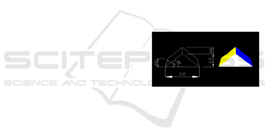
Firstly, select shape of the obstacle. Relevant data
indicate that the visual impact of the prism to human
eyes is relatively moderate. The three-dimensional
entity of triangular prism can properly create a
reasonable sense of slope on the road, so that the
three-dimensional effect of the marking simulation is
more real. Thus the three-dimensional entity used in
the simulation is triangular prism.
Secondly, when determining the cross-sectional
dimensions of the obstacle, the compatibility with
road width needs to be considered. Generally, the
width of a single lane is 3.5 m, and the average
width of vehicles is 2.5 m. In order to ensure that the
distance between the designed markings is not less
than the vehicle width, the distance between the
edge of designed marking and the road edge should
be 0.5 m. At the same time, considering that setting
up two three-dimensional markings on the same
cross-section of each lane can uniformly fill the
entire width of the pavement. Thus the width of the
three-dimensional marking is 1.0 m.
Finally, determine the projective length of the
obstacle. In the national standard GB-5768, the
spacing distance between most of the deceleration
markings is in the range of 5 to 20 meters. Taking
into account the cross-sectional dimension, choose 5
m as the projective length of the three-dimensional
marking, that is, the value of the road obstacle
dimension B is 5 m.
3.2.3 The Vertical Distance between the
Driver's Line of Sight and the Obstacle
According to the national standards, the height of
driver's eye in vehicle is 1.2 m, that is, the value of
vertical distance between the driver's line of sight
and the obstacle C is 1.2 m.
3.2.4 Simulation Results
The parameters A (22 m), B (5 m) and C (1.2 m) are
input to the simulation scene (Figure 1). The
projective pattern observed from the camera's
perspective is captured, and the geometric
dimensions are plotted in the software to complete
the dimension design. Combined with the study of
colors, the final design of the deceleration marking
is shown in Figure 2.
Figure 2 Deceleration marking design results.
3.3 Design of Guidance Marking
The prototype of the three-dimensional guidance
marking is derived from the diamond longitudinal
deceleration marking, and the design method is
similar to that of the deceleration marking in section
3.2. In order to enhance the guidance function of the
marking, sweep the diamond plane alone the oblique
direction in AutoCAD software, and select the
sweeping result oblique hexahedron as the
three-dimensional entity. The specific design of the
guidance marking is as follows (details similar with
the deceleration marking are not repeated here):
3.3.1 The Dimensions of the Obstacle
According to the relevant regulations in the national
standard GB5768, the length of road longitudinal
deceleration marking should be 100 cm, which is the
same with the length of three-dimensional guidance
marking. In order to avoid too much pressure for the
ICECTT 2018 - 3rd International Conference on Electromechanical Control Technology and Transportation
248
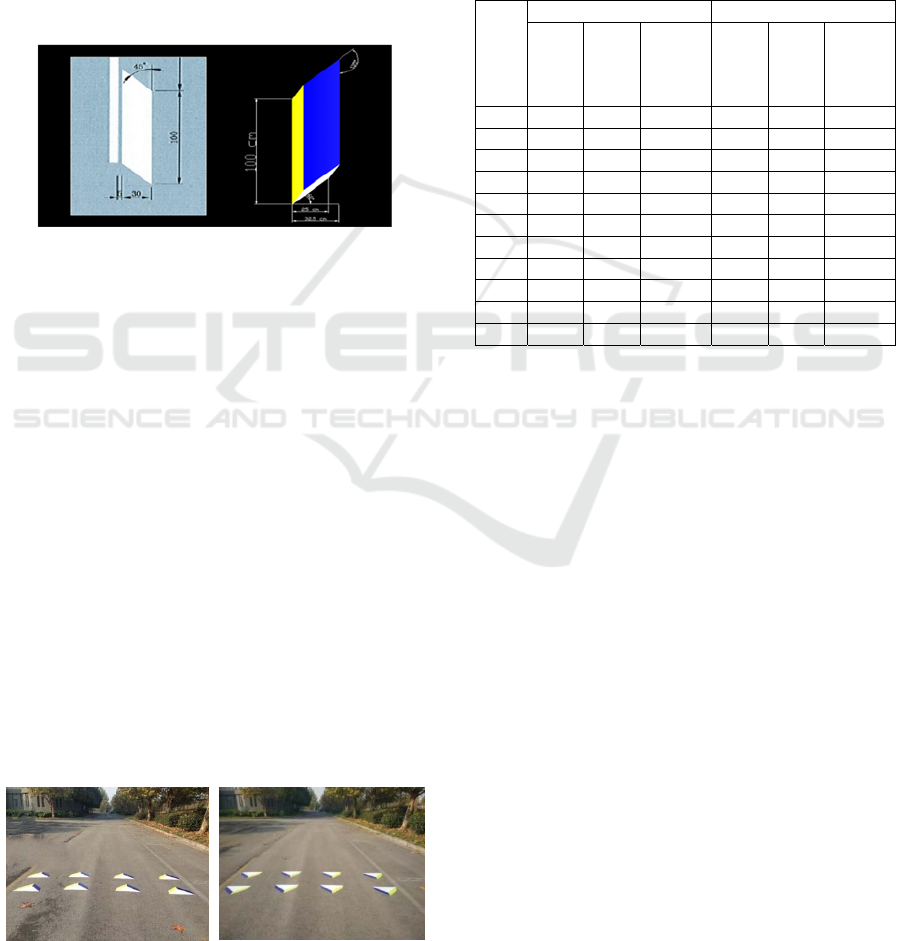
driver in the process of driving, the width of
three-dimensional marking is set to 32.5 cm. The
road width is more than 3.1 m after subtracting the
marking width, which still belongs to the driver's
acceptable range.
3.3.2 Simulation Results
Considering the requirement of convenient
construction, the perspective projection is simply
optimized to remove the small angle change caused
by the sight distance. The optimized result is the
final design result of the three-dimensional guidance
marking which is shown in Figure 3.
Figure 3 Guidance marking design results.
4 EXPERIMENT VERIFICATION
The research team set up two kinds of
three-dimensional markings in Southeast University
Jiulonghu campus and carried out two sets of
experiments to test the deceleration and guidance
effect of the three-dimensional markings in practical
application. The speed change rate on the straight
and the deviation of the trajectory on the curve were
selected as the evaluation index in the experiments.
4.1 Deceleration Marking Verification
The experimental verification of the deceleration
marking is located on the straight and consists of
two groups of experiments, which belongs to the
comparison experiment. The difference between the
two groups is only in the way laying the same
deceleration marking on the road, forward and
reverse. The effect of layouts is shown in Figure 4.
Figure 4 Forward and reverse layouts.
In order to make the experimental results more
universal, a total of 10 drivers participated in the
experiment. When the test driver drove through the
experimental section, the other two team members
respectively measured the speed of the vehicle into
and out of the experimental section with hand-held
radar tachometer. A total of 20 sets of data were
measured to calculate the speed change rate, the
changes of vehicle speed are shown in Table 1.
Table 1 Speed change of vehicles passing through
experimental sections.
ID
Forward Layouts Reverse Layouts
ܸ
(km/
h)
ܸ
(km/
h)
Speed
Chang
e Rate
(
%
)
ܸ
(km/
h)
ܸ
(km/
h)
Speed
Chang
e Rate
(
%
)
1 21 14 33.3% 20 15 25.0%
2 30 19 36.7% 35 27 22.9%
3 35 26 25.7% 39 30 23.1%
4 37 25 32.4% 40 33 17.5%
5 38 28 26.3% 40 34 15.0%
6 42 33 21.4% 42 36 14.3%
7 45 36 20.0% 44 36 18.2%
8 50 30 40.0% 50 42 16.0%
9 58 40 31.0% 53 40 24.5%
10 61 46 24.6% 58 46 20.7%
Ave 41.7 29.7 29.2% 42.1 33.9 19.7%
It can be seen from the above table that the actual
deceleration effect of the forward layouts (29.15%)
is significantly better than that of the reverse layouts
(19.71%). After vehicles passing through the
deceleration marking in forward layouts, the average
speed can be controlled below the safe speed at 30
km/h. Therefore we can draw a conclusion that the
three-dimensional deceleration marking can achieve
good deceleration effect in the practical application.
4.2 Guidance Marking Verification
The experimental verification of the guidance
marking is located on the curve and consists of two
groups of experiments, which belongs to the control
experiment. There were no any treatments to the
curve in the control group, but guidance marking
was laid on the curve in the experimental group. The
effect of layouts in experimental group is shown in
Figure 5.
Optimization Design of Traffic Marking in Urban CBD Area
249
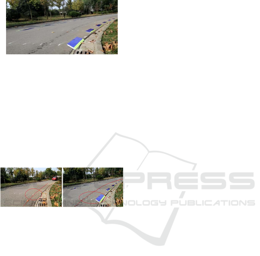
Figure 5 Guidance marking layouts.
Before the start of the experiment, take off the
model aircraft near the experimental areas, and set
the model aircraft hovering automatically above the
experimental section to begin the observation
mission. When participants drove through the
experimental section, it was recorded by the camera.
Latter using video processing software to extract the
vehicle trajectory through the curve with or without
the guidance marking respectively, and to compare
the deviation of the trajectory when vehicles passing
through the curve.
After the technical processing, the trajectory of
vehicles passing through the curve is shown in
Figure 6.
Figure 6 Comparison graphs of vehicles' trajectory.
It can be seen from the figure that the trajectory
of the vehicle passing through the curve in the case
without the guidance marking is closer to the edge of
the road than the trajectory in the case with the
guidance marking, and the guidance marking plays a
role in reducing the lateral deviation of the vehicle
on the curve. By contrast we can draw a conclusion
that the three-dimensional guidance marking can
achieve good guidance effect in the practical
application.
5 CONCLUSION
In this paper, through the analysis of human visual
perception and visual illusion principle, designing
method and basis of three-dimensional marking are
gradually got. This paper aims to make up for the
lack of research on three-dimensional marking, so as
to form the research system for three-dimensional
marking. Finally the design of the three-dimensional
marking applicable to different road conditions can
be used directly for the traffic departments. The
research results are summarized as follows:
First, this paper presents a scientific method to
design three-dimensional marking, which can
achieve good visual illusion of obstacles, and gives a
detailed design scheme of three-dimensional
deceleration and guidance markings;
Second, the three-dimensional guidance marking
designed in this paper can be used to reduce the
lateral deviation of the vehicle, and the deceleration
marking can be optimized by analogy to make it
have a three-dimensional effect;
Last, this paper makes three-dimensional
optimization design to some traffic markings in
urban CBD area, which can solve some problems
existing in reality and improve safety and order for
traffic in CBD area.
Reasonable traffic organization is particularly
important for the urban CBD area with shortages of
land and high traffic flow. The three-dimensional
marking proposed by this paper can adapt well to the
traffic characteristics of the CBD area, and solve
some traffic problems. What's more, the
three-dimensional marking with low cost and
obvious effect, is suitable for promotion in urban
CBD area to ensure the safety and order of the CBD
area. For urban CBD area, the three-dimensional
marking will have very broad prospects for
development!
ACKNOWLEDGEMENTS
This research was supported by the key project of
National Natural Science Foundation of China
(Grant No.51338003).
REFERENCES
Charlton, S. G., Mackie, H. W., et al, 2010. Using
endemic road features to create self-explaining roads
and reduce vehicle speeds. Accident Analysis &
Prevention, 2010, 42(6):1989-1998.
Katz, B. J. & Duke, D. E, 2006. Design and Evaluation of
Peripheral Transverse Bars to Reduce Vehicle Speeds.
Transportation Research Board 85th Annual Meeting.
Liang, G., Qian, G., Wang, Y, et al, 2017. Design of a
3-dimensional visual illusion speed reduction marking
scheme. International Journal of Occupational Safety
& Ergonomics, 2017, 23(1): 92-104.
Puan, O. C., Halim, S., & Ibrahim, M. N, 2015. Empirical
evaluation of drivers’ operating speeds along
ICECTT 2018 - 3rd International Conference on Electromechanical Control Technology and Transportation
250

curvatures on single carriageway roads. Jurnal
Teknologi, 2015, 73(4).
Qin, B., Liu, W., Shen, X., et al, 2013. A general
framework for road marking detection and analysis.
International IEEE Conference on Intelligent
Transportation Systems, IEEE, 2013:619-625.
Optimization Design of Traffic Marking in Urban CBD Area
251
