
Monitoring Tides with GNSS Buoys in Open Sea Areas
Weikang Sun
1,2
, Xinghua Zhou
1,2,*
, Yanguang Fu
1,2
, Zhaoyang Wang
3
and Dongxu Zhou
2
1
College of Geomatics, Shandong University of Science and Technology, Qingdao, 266590, China;
2
First Institute of Oceanography, State Oceanic Administration, Qingdao, 266061, China.
3
National Marine Information Center,Tianjin, 300171, China
Email: xhzhou@fio.org.cn
Keywords: GNSS buoys, open sea, Kalman filters, prior information, tide model
Abstract: Nowadays, the coastal tide observation technology has developed very well. However, there still lacks a
reliable and quick method of acquiring tidal level in open sea areas. To overcome this problem, a GNSS
buoy has been developed, which is equipped with data acquisition system and shore station system. Also,
some tidal level extraction algorithms are also proposed. Based on Precision Point Positioning, the GNSS
data is calculated. Kalman filtering, attitude correction, smoothing, and sampling are performed on the high-
frequency GNSS solution results. And the above results are corrected using the prior periodic information.
The tidal level derived from the GNSS buoy without and with prior periodic information are compared with
the tidal level derived from the regional tide model (NAO.99Jb). The RMSE are 7.6cm and 4.8cm,
respectively. Also, the tidal level derived from the GNSS buoy with prior periodic information in spring tide
period are less accurate than it in neap tide period. The RMSE are 6.4cm and 3.7cm, respectively. The
results show that GNSS buoy can provide high accuracy tidal level.
1 INTRODUCTION
At present, marine observation buoys have
developed rapidly and maturely, including wave
buoys, tsunami buoys (Kato et al., 2008) and so on.
GNSS buoys are a new type of marine surveying
instrument that has emerged with the rapid
development of GNSS satellite positioning
technology since the early 1990s. It can obtain high
precision tidal level and carry out the correction of
the sounding in the offshore areas. It is of great
significance for the construction of the channel and
the safety of the navigation. The measurement
principle of GNSS buoys is to obtain the precise
spatial geocentric coordinates of the phase center of
the GNSS antenna through GNSS Real Time
Kinematics(RTK), post-processing kinematics(PPK)
or precise point positioning (PPP). Then combined
with the measured height of the center of the
antenna's phase relative to the water surface, a time-
sampling sequence of the height from the sea surface
to the reference ellipsoid can be obtained. The
GNSS buoy measurement principle is shown in
Figure 1 (Bisnath, 2004):
Figure 1: The principle of GNSS buoy measurement.
When using the GNSS buoy to observe the water
level, the GNSS buoy elevation observation data has
a lot of noise due to the influence of the GNSS
observation error, the sea wave, the change of the
buoy attitude and so on (Bisnath, 2004). At present,
the GNSS observation error can be effectively
eliminated by using a perfect model and method
Sun, W., Zhou, X., Fu, Y., Wang, Z. and Zhou, D.
Monitoring Tides with GNSS Buoys in Open Sea Areas.
In Proceedings of the International Workshop on Environment and Geoscience (IWEG 2018), pages 105-109
ISBN: 978-989-758-342-1
Copyright © 2018 by SCITEPRESS – Science and Technology Publications, Lda. All rights reserved
105

(Hein et al., 1992; Kelecy et al., 2011), and the error
of the buoy attitude change can be eliminated by the
attitude correction. Therefore, eliminating the
influence of ocean waves in GNSS buoy height data
is particularly important. In distant sea areas,
changes in the attitude of the carrier caused by wind
waves will bring greater errors to the tide measuring
(Yang and Zhao, 2003; Zhao et al., 2006). The
attitude correction technology can reduce the error
effect caused by severe shaking of the carrier to the
tide inspection. The PPK or PPP mode is not limited
by radio signal transmission and can further expand
the tide measuring range. Therefore, PPK or PPP
mode can be considered for tide measuring
combined with attitude parameters in the offshore
areas.
Aiming at these problems, a combined GNSS
buoy was developed and a new algorithm for
extracting tidal information was proposed.
2 BUOY DEVELOPMENT
The GNSS buoy is mainly composed of two parts:
data acquisition system and shore station system.
The data acquisition system includes an
embedded data collector, a high-precision attitude
sensor, a high-accuracy GNSS module, a Beidou
transmit signal module, a power supply voltage
regulator module, and a corresponding software
system. The system can be operated independently
to collect raw observations of GNSS tidal level
measurements. The GNSS receiver is an
independently developed multimode and multi
frequency data acquisition device with the
NOV703GGG.R2 antenna. The TCM2.5 attitude
instrument is integrated inside the system and is
used to measure the instantaneous roll, pitch and
heave, providing attitude correction parameters for
the GNSS tidal data. The data collector of the buoy
is installed in the buoy cabin, and the GNSS antenna
and Beidou satellite terminal are installed on the
bracket at the buoy platform.
The shore station system includes the Beidou
reception signal module, data monitoring module,
and data preprocessing module. The system is used
to monitor the operational status of the buoy, such as
buoy position information, attitude information and
the working status of each module.
3 INTRODUCTION OF OPEN SEA
EXPERIMENT
Before the GNSS buoy was placed to the measuring
areas, the elevation of the antenna should be
calculated first.
A dynamic calibration method of measuring GPS
buoy antenna elevation based on GPS PPK and
synchronous tide observation data was adopted
(Zhou et al., 2015). After installing and debugging
the GNSS buoy system, the base station was set up
at the wharf, which was about 20m from the GNSS
buoy. At the same time, a pressure tide gauge was
installed at the same site with the base station to
observe the tidal level. Combined with three CORS
stations of Shipu, Dongshan and Kanmen in the
coastal GNSS observation network, the three-
dimensional coordinates of the base station under
the framework of ITRF2008 were obtained. Using
the synchronous observation data from the base
station, the dynamic coordinates of the GNSS buoy
antenna phase center are solved one epoch by one
epoch with the using of the Differential method. The
tidal level recorded by the tide gauge was converted
to geodetic height. The GNSS buoy's dynamic
antenna elevation was processed by a moving
average method, and the tidal level of geodetic
height recorded by the tide gauge was subtracted.
Then the GNSS buoy dynamic antenna elevation can
be obtained.
After completing the buoy antenna elevation
measurement, the buoy was placed in the East China
Sea for continuous observation of tidal level (shown
in Figure.2).
Figure 2: The distribution of reference stations and GNSS
buoy.
IWEG 2018 - International Workshop on Environment and Geoscience
106

4 DATA PROCESSING
4.1 GNSS Data Processing Based on
PPP Technology
The PPP location technology does not require a
reference station. Single epoch-precise single point
positioning is performed after initialization with the
using of the non-differential dual-frequency carrier
phase observations. Using post-processing mode, the
precise ephemeris and clock difference files
provided by IGS were selected, and then the phase
or pseudo-range observations collected by a single
receiver were subjected to non-differential
positioning processing.
4.2 Tidal Level Extraction
We developed a three steps procedure to extract the
actual tidal level from the GNSS data and to
subsample the data from 1sec intervals to 1min
interval. The data processing of the GNSS buoy is
performed by PPP technology, and the series of the
antenna phase center elevation is obtained.
4.2.1 Kalman Filtering
The best estimation criterion of the Kalman filtering
is the minimum mean square error, which requires
that the optimal estimation of the signal or state
should have the smallest error variance from the
corresponding true value. The basic idea is to use
the state space model of signal and noise, update the
estimation of the state variables with the estimates
of the previous time and the observations at the
current moment, and find the estimated value at the
moment of occurrence. Kalman filtering is an
efficient recursive filter that can estimate the state of
a dynamic system from a series of measurements
that do not completely contain noise.
4.2.2 Intermediate Data Subsampling and
Smoothing
In this step, the GPS raw data is subsampled at
1minute intervals. From this subsampled series,
records are smoothed by a 60minute average
window (Apel et al., 2012). The smoothing is
performed bi-directionally over the time series in
order to prevent phase shifts.
4.2.3 GNSS Buoy Data Processing with
Prior Periodic Information
With the rapid development of modern geodetic
technology, measuring methods are becoming more
and more advanced, and geodetic data has become
more and more abundant. Our understanding of the
geometric, physical and mechanical properties of
any observing target or object is also becoming
more and more sufficient, and the possibility of
establishing periodic based on prior information is
increasing. In the technique of extracting tidal
information from GNSS buoys, we know the period
information of each constituent, instantaneous tidal
level can be expressed as (Huang and Huang, 2005):
0
( ) ( cos sin )+ ( )
n
j j j j
j
t A t B t x t
(1)
Where,
()t
represent GNSS buoy-derived time
series;
n
is the number of constituents;
is the
angular rate of constituents;
t
is time;
()xt
is non-
astronomical tidal level and
AB、
are coefficient
matrixes waiting to be solved.
Taking into account the time length of
()t
, the
appropriate constituents should be selected and the
coefficient matrix of
AB、
can be solved.
()xt
can be obtained by polynomial fitting. Through the
obtained coefficient matrix
AB、
, non-
astronomical tidal level
()xt
, and known
constituents periodic information, the new
()t
can
be obtained, which is the tidal level extracted from
the GNSS buoy after corrected by the prior periodic
information. The tidal level terms are long-period
items, the period is generally several hours to ten
hours; the surge-wave items are short-wave items,
and the period is generally tens of seconds to tens of
minutes. The influence of short period surge-wave
can be eliminated by selecting the appropriate tide.
5 RESULTS AND DISCUSSION
The PPP calculation results for a single day are
shown in Figure 3. 7 April was chosen, as it was a
representative sample of the entire dataset. The data
set is referenced to WGS84 ellipsoid.
Monitoring Tides with GNSS Buoys in Open Sea Areas
107
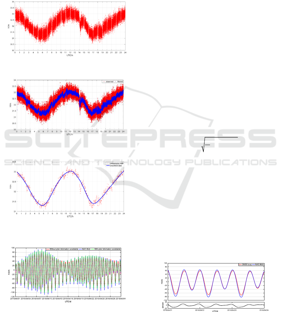
As suggested in Figure 3, the processing filter
noise was a high frequency signal riding upon the
lower frequency water level changes. After Kalman
filtering, most of the gross errors were eliminated, as
shown in Figure 4.
Figure 3: GNSS buoy height solutions for 7 April 2016.
Figure 4: GNSS buoy height solutions and filtered data for
7 April 2016.
Figure 5: Subsampled and smoothed GNSS buoy height
solutions for 7 April 2016.
Figure 6: GNSS buoy height solutions verses NAO.99Jb
for the entire month of April.
The data in April was processed day-by-day
according to the above steps, and the overall results
for April were obtained. Then, the prior information
was used to correct the overall results in April. The
reference datum was transformed from WGS84
ellipsoid to monthly mean sea level. Compare the
two results with NAO.99Jb, as shown in Figure 6.
Since the GNSS buoy was far away fro m the
mainland and there was no tide gauge station in the
surrounding area, the NAO.99Jb tidal model was
selected to verify the accuracy of GNSS buoys for
measuring tidal level. The NAO.99Jb tidal model is
a regional tidal model constructed by the Japanese
National Observatory based on two-dimensional
nonlinear equations using the Blending assimilation
method (Matsumoto et al., 2000). Compared with
other global models, NAO.99Jb has the highest
accuracy in the layout areas of the buoy (Fu et al.,
2017) .
Figure 6 shows that the tide data without prior
information periodic are less accurate than the tide
data with prior information periodic compared with
the NAO.99Jb. The RMSE is 7.6cm and 4.8cm,
respectively. The RMSE is defined as (Lin et al.,
2017):
2
1
1
ˆ
N
tt
t
RMSE y y
N
(2)
where,
t
y
and
ˆ
t
y
represent the tides obtained
from the regional tide model NAO.99Jb and the
GNSS buoy, respectively, and N is the number of
tide data.
It is proved that the tidal level correction based
on priori periodic information has a great
contribution to improving the accuracy of GNSS
buoys for extracting tidal information. Notably, the
amplitude of the GNSS buoy height solutions is
smaller than it of NAO.99Jb. A possible reason is
the inclination of the GNSS buoy (Lin et al., 2017).
Another possible reason is that the bathymetry
model that the NAO.99Jb used are not accuracy
enough, which affect the tidal level calculation.
Figure 7: GNSS buoy height solutions with prior periodic
information verses NAO.99Jb for the spring tide.
IWEG 2018 - International Workshop on Environment and Geoscience
108
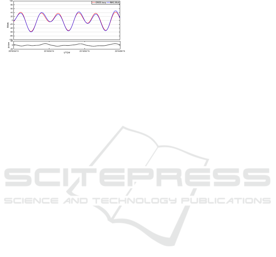
Figure 8: GNSS buoy height solutions with prior periodic
information verses NAO.99Jb for the neap tide.
As can be seen from Figure 7 and Figure 8, the
tide period measured by the GNSS buoy is in good
agreement with the model. The accuracy in spring
tide period is lower than it in neap tide period. The
RMSE is 6.4cm and 3.7cm respectively.
6 CONCLUSIONS
Using GNSS technology to measure tidal level is a
new measurement method. This article introduces in
detail the measurement of tidal level in coastal areas
and open sea with the using of the modular GNSS
buoy.
By making full use of the precise three-
dimensional dynamic measurement technology of
precise point positioning, it is possible to measure
tidal level in areas where traditional methods are
difficult to perform and in open sea areas. Through a
series of processing to the elevation of the antenna,
such as Kalman filtering, attitude correction,
smoothing, subsampling and adding prior periodic
information correction, the time series of tidal level
with the accuracy of cm level can be obtained.
The open sea GNSS buoys have high
observation accuracy, and the deployment is not
limited by sea and land conditions. If long-term
effective observations are carried out, reliable tidal
level information can be obtained. On the one hand,
it is possible to supplement the tidal data with the
construction of a global tidal model to improve its
construction accuracy. On the other hand, the GNSS
buoy can be used to calibrate the altimeter directly at
the sub-satellite point. This method is not affected
by tidal models and geoid and it and is widely used
in the study of altimeter calibration (Bonnefond et
al., 2003).
The prospect of the application of buoys is to
realize the extraction of real-time tidal level, further
investigation is required to resolve the discrepancies
between the real-time and post-processed solutions.
We should give full play to the applicability and
expandability of GNSS buoy technology in marine
surveillance in the near future.
REFERENCES
Apel H, Hung N G, Thoss H, et al 2012 GPS buoys for
stage monitoring of large rivers Journal of Hydrology
412 182-192
Bisnath S 2004 Development of an Operational RTK
GPS-equipped Buoy for Tidal Datum Determination
International Hydrographic Review 54-64
Bonnefond P, Exertier P, Laurain O, et al 2003 Leveling
the Sea Surface Using a GPS-Catamaran Special Issue
Jason-1 Calibration/Validation Marine Geodesy 26
319-334
Fu Y G, Zhou X H, Zhou D X, et al 2017 Accuracy
analysis of ocean tidal model over China seas based on
the gauge data Science of Surveying and Mapping 42
28-32
Hein G W, Blomenhofer H, Landau H, et al 1992
Measuring Sea Level Changes Using Gps in Buoys Sea
Level Changes Determination and Effects American
Geophysical Union 101-105
Huang Z K, Huang L 2005 Tidal Principles and
Calculations
Kato T, Terada Y, Nagai T, et al 2008 Development of a
new Tsunami Monitoring System Using a GPS Buoy
AGU Fall Meeting
Kelecy T M, Born G H, Parke M E, et al 2011 Precise
mean sea level measurements using the Global
Positioning System Journal of Geophysical Research
Oceans 99 7951-7959
Lin Y P, Huang C J, Chen S H, et al 2017 Development of
a GNSS Buoy for Monitoring Water Surface
Elevations in Estuaries and Coastal Areas Sensors 17
1-19
Matsumoto K, Takanezawa T, Ooe M 2000 Ocean Tide
Models Developed by Assimilating
TOPEX/POSEIDON Altimeter Data into
Hydrodynamical Model A Global Model and a
Regional Model around Japan Journal of
Oceanography 56 567-581
Yang F L, Zhao J H 2003 Analyzing and Eliminating the
Effect of Wave in GPS Tide Observing Hydrographic
Surveying and Charting 23 1-4
Zhao J H, Zhang H M, Hughes-Clarke J E 2006
Determination of Precise Instantaneous Tidal Level at
Vessel Geomatics and Information Science of Wuhan
University 31 1067-1070
Zhou D X, Zhou X H, Liang G H, et al 2015 Research on
dynamic calibration method of GPS buoy Science of
Surveying and Mapping 40 121-124
Monitoring Tides with GNSS Buoys in Open Sea Areas
109
