
Biodiversity-Oriented Security Patterns of Wetlands in Build-Up
Areas
Yanan Wang, Jinmei Yang, Lirong Wang and Qing Chang
*
Department of Ornamental Horticulture and Landscape Architecture, China Agricultural University, Beijing 100193,
China.
Email: changqing@cau.edu.cn
Keywords: Biodiversity, wetland conservation, security patterns, urban area
Abstract: The wetland has the richest biodiversity among all the natural ecosystems. With the rapid growth of
population and the extension of urban area, the shrinking and fragmentation of wetlands have consequently
lead to the loss of wildlife. This paper proposed a framework for building the security pattern of wetlands
for the biodiversity conservation. It took the build-up area of Haikou as study case, constructed a potential
pattern in urban areas to protect both the wetland habitats and the migratory paths of wetland wildlife. We
built the security patterns of wetlands and divided it into three units with different protection measures,
which include the basic security pattern, moderate security pattern and optimal security pattern, accounting
for 14.27%, 25.42% and 44.81% of the total area respectively. It is hoped that this spatial qualified approach
could be applied in urban planning and design practices in the future.
1 INTRODUCTION
Wetlands are indispensable since they provide
various ecosystem services, which include
producing foods and materials, regulating the
climate, removing pollutants, providing habitats for
wildlife and so on (
Costanza et al. 1997; Mitsch and
Gosselink, 2007). Especially, the wetland contains the
richest biodiversity among all the natural
ecosystems (
Pearee, 2002). The wetland provides
habitats for 20% of the species in the Earth
(
Dugan,1993), although it only covers about 1% of
the total surface.
However, wetlands have been facing the
increasing risk of shrinking and fragmentation with
population explosion and urban extension. Since
early 20th century, more than half of the wetlands
have been lost in North America, Europe, Australia,
and China (
Mitsch and Gosselink, 2007). Dredging,
draining, and other human activities are the main
driving factors of the losses and fragmentation
(
Gibbs, 2000). There is a terrifying trend that the
wetland shrinkage led to the destruction of
biodiversity directly or indirectly. A greater
percentage of endangered or threatened species
distributed in the wetlands area (
Boyland and
MacLean, 1998; Sun et al, 2017
). The conflicts between
wetland protection and development have become
one of the most concerned topics in recent years.
Some researchers believed that the conflicts between
urban development and wildlife protection have
reached a dangerous situation (
Lemly et al, 2000).
Many institutions and organizations are now
strategically planning for the conservation of
wetlands resources. Scientists, managers and
volunteers have attempted to restore the degraded
wetlands, but it is difficult to recover the wetland
ecosystem structure and functions to original level.
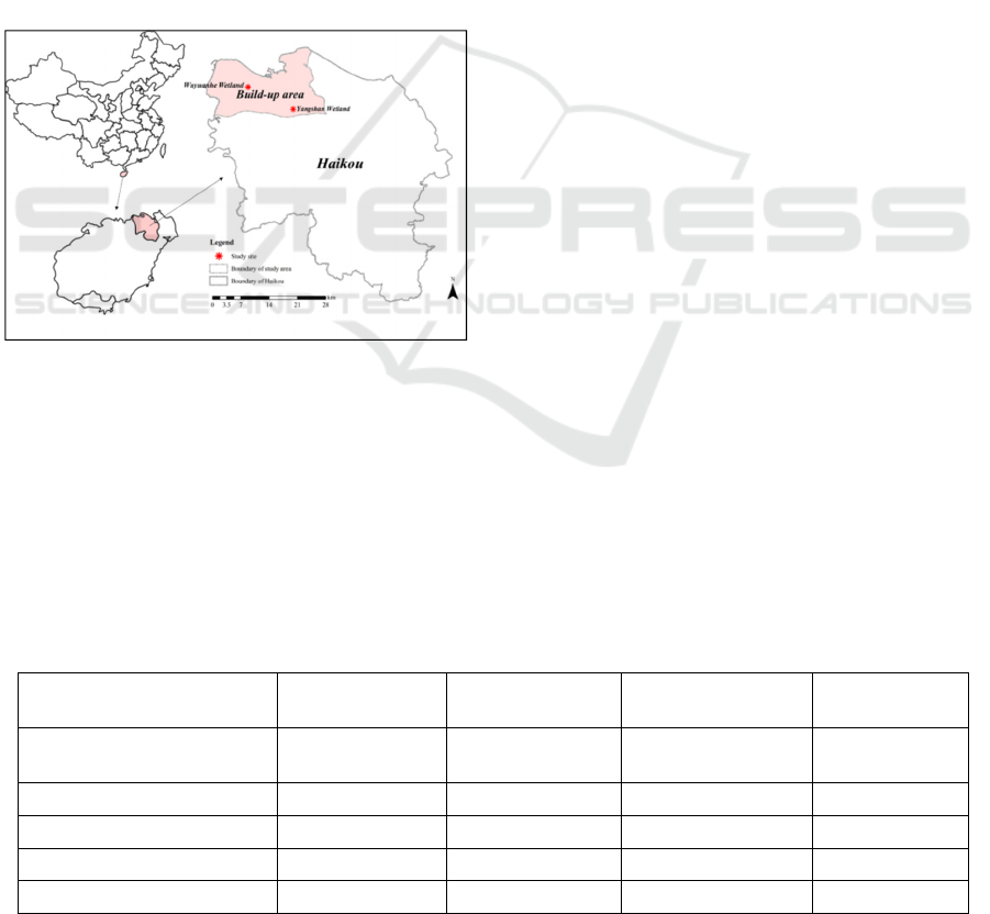
As for the case study area, Haikou (110°32′–
110°37′ E, 19°51′–20°01′ N) is invested for the
research. It is the capital city of Hainan Province,
located in the northern part of Hainan Island, and in
the northern margin of tropical latitudes, with
tropical island monsoon climate. Unique
geographical location and climatic conditions of
Haikou gave birth to many characteristic landscapes
such mangroves and other types of wetlands, with
rich biodiversity. However, as a result of industrial
development, agricultural development and
reclamation, etc Wetlands space have been suffering
occupied or landfilled by urban construction.
Invasion of alien species and the destruction of
wetland ecosystems have caused a great loss of
habitats of native wetland animals and plants,
leading to the damage of biodiversity. The
Wang, Y., Yang, J., Wang, L. and Chang, Q.
Biodiversity-Oriented Security Patterns of Wetlands in Build-Up Areas.
In Proceedings of the International Workshop on Environment and Geoscience (IWEG 2018), pages 145-149
ISBN: 978-989-758-342-1
Copyright © 2018 by SCITEPRESS – Science and Technology Publications, Lda. All rights reserved
145
protection of wetland ecosystems of Haikou is
imminent. Thus, further research is needed to
provide reference for managers about how to utilize
wetlands sustainably and provide suitable habitat for
wildlife. Based on the background above, we
attempt to build the biodiversity-oriented security
patterns of wetlands in the build-up areas of Haikou.
2 STUDY AREA AND METHODS
2.1 Study Area
In this paper, we choose the build-up area of Haikou
as the study area. The total area is 323.87km
2
. There
are two typical wetlands in the build-up area of
Haikou, Wuyuan River Wetland and Yangshan
Wetland (Figure 1).
Figure 1: Location of the study area.
Wuyuan River is distributed in the northwest of
study area, which adequates water resources, forests,
shrubs with large evaporation and high humidity.
The environment might provide excellent habitats
for the living of wildlife. However, in recent years,
some patches along Wuyuan River have been
developed, and the native habitats for alien species
such as Ampullariidae (Pomacea canaliculate which
is well known as alien species) are increasingly
ruined by human activities. This inevitably leads to
the losses of the biodiversity along Wuyuan River.
Yangshan Wetland located in the southeast of
study area. It belongs to natural volcanic wetland
ecosystem bred by the volcanic ash soil and
underwater diving through surface fissures of the
volcanic landform. Yangshan wetland contains
rivers, lakes, ponds, reservoirs, tropical swamps, and
paddy fields, which is pregnant with the rich
biodiversity.
2.2 Methods
We proposed a hierarchical framework with three
steps. The framework includes identifying habitats
and the potential migration paths in wetlands of
wildlife, extending wetland biodiversity
conservation from in situ conservation to overall
conservation and increasing the connectivity of
wetlands.
2.2.1 Step1- Define the Distribution of Core
Habitats
The soil of wetlands saturated with water
permanently or seasonally, such that it breeds the
rich biodiversity. To build the security patterns of
wetlands, the most urgent task is to protect the core
habitats, for instance, existing wetlands and forests.
For different wetlands, according to the formation
mechanism of the wetlands, we define tropical
swamps, paddy fields, volcanic ash soil and other
elements as the core habitats. Forests mostly
distributed around wetlands, are also of great
importance for biodiversity conservation and
maintain the ecological processes. The area of core
habitats is displayed in Figure 2. The total area of
wetlands is 33.65km
2
, and the total area of forests is
50.12km
2
.
Table 1: The indicators of wetlands importance evaluation.
Indicators Extremely important Moderately
important
Generally important Not important
Land use type swamps, rivers,
beaches etc.
paddy fields, forests
etc.
farmland, shrubs,
grasslands etc.
bare fields,
urban areas.
Soil type volcanic ash soil absence absence other soil types
Distance to a river or lake (m) <200 200-500 500-1000 >1000
Distance to the mangroves (m) <100 100-200 200-500 >500
Distance to the tide line (m) <50 50-100 100-200 >200
IWEG 2018 - International Workshop on Environment and Geoscience
146
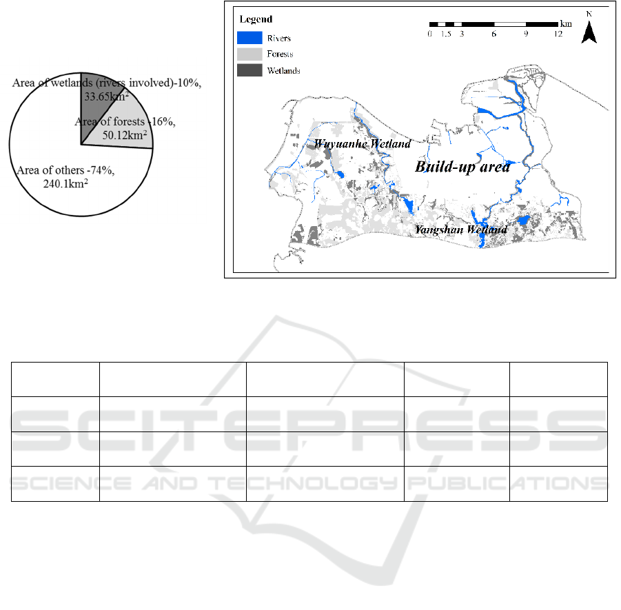
Figure 2: Area statistics. Figure 3: The distribution of core habitats.
Table 2
:
Suitability evaluation indicators of Great Egrets.
Indicators Extremely suitable Moderately suitable Generally
suitable
Not suitable
Land use type wetlands, rivers, beaches et
al.
paddy fields, forests et al. farmland, shrubs,
grasslands et al.
bare fields,
urban areas.
Distance to a
river or lake (m)
<200 200-500 500-1000 >1000
Distance to the
urban areas (m)
>1000 600-1000 400-600 <400
As it can be seen from the Figure 3, the
distribution of wetlands of Wuyuan River Wetland
and Yangshan Wetland is fragmented, we selected
specific indicators to evaluate the importance of the
existing core habitats, the indicators are listed in
Table 1.
2.2.2 Step2-Choose the Focal Wetland
Species in the Study Area
Proposed by Lambeck in 1997, the focal species
approach built on the single-species umbrella
approach. The underlying premise is that well-
chosen focal species provide a protective umbrella
for other species (
Lambeck, 1997
). Birds are good
indicators of the surrounding ecological
environment (
Zhao and Lei, 2002
). In this paper, we
referred to the wetland birds’ directory of Haikou,
combined with the vegetation and rivers
characteristics of the study area, chose the Great
egret as focal species. Great egret (Egretta alba) is a
large, widely distributed egret species, distributed
across most of the tropical and warm temperate
regions of the world. It builds tree nests in colonies
close to water, so it is an important indicator of
wetlands biology.
We analyzed the habitat characteristics of Great
egret and list the suitability evaluation indicators
(Table 2) to evaluate the habitat suitability of Great
Egrets.
2.2.3 Step3-Analyze Potential Migration
Corridors of Great Egrets
Establishing paths for wild animals among
wetlands could increase the connectivity of wetlands
and consequently enhance the migration of wildlife.
Based on environmental factors and human
interference factors in the minimum cumulative
resistance (MCR) model, we can get a resistance
Biodiversity-Oriented Security Patterns of Wetlands in Build-Up Areas
147

plane that reflects the potential and trends of species
movements and identify the potential wildlife
migration corridors.
The minimum cumulative resistance (MCR)
model was proposed by Dutch ecologist Knappen
and was applied to the study of species diffusion
process (
Knaapen et al, 1992
). Based on the minimum
cumulative resistance (MCR) model, the resistance
factors and resistance coefficients of the Great
egrets’ movements are listed in Table 3. To identify
the potential migration corridors, the resistance
plane of the Great egret is established according to
the factors as follows.
Table 3
:
Resistance factors and resistance
coefficients of the Great egrets’ movements
.
Resistance factors
Resistance
coefficients (1-
100)
Wetlands, rivers, beaches etc. 1
Paddy fields, forests etc. 10
Farmland, shrubs, grasslands
etc.
50
Bare fields, urban areas. 100
3 RESULTS
Based on the above methods, we built the security
patterns of wetlands and divided it into three units
with different protection measures (Figure 4), which
include the basic security pattern, moderate security
pattern and optimal security pattern. We have
calculated the area of different security pattern units
and listed in Figure 5.
Figure 4: The security patterns of wetlands in Haikou
build-up area.
Fi
g
ure 5: Area statistics of different securit
y
p
attern units.
Basic security pattern is the basic line for
protecting the wetland biodiversity in the study area
and should be strictly protected. The area of the
basic security pattern is 46.21km
2
, accounting for
14.27% of the total area. It contained the core area
of the Wuyuan River and the Yangshan Wetland,
and the potential migration corridors. Swamps,
paddy fields and rivers were included in this pattern.
The corridors located in the southwest of the study
area, which is the potential migration path for
wildlife. Decision makers and managers should set
up wildlife observation stations and rescue facilities
to conduct scientific research in these areas,
prohibiting any exploitation and construction
activities.
Moderate security pattern aims to protect the
existing wetland and surrounding ecological land
patches, and reduce the continuing fragmentation of
wetlands. The area of moderate security pattern is
36.12km
2
, accounting for 11.15% of the total area. It
located around the basic security pattern. Within
these areas, forests, shrubs and grassland were
staggered with wetlands, which might contribute to
linking the existing wetland patches as a whole
network. Thereby, urban development and
construction should be limited in moderate security
pattern to reduce the human disturbance of the basic
security pattern.
Optimal security pattern is the buffer area
between build-up area and natural habitats, which
aims to control the excessive urban expansion and
human activities in urbanization process. The area of
the optimal security pattern is 62.68km
2
, accounting
for 19.36% of the total area. It contains a large area
of forests and other land use types as grassland and
farmland. The ecological lands in these areas have
great effect on balance the relationship between
construction and protection of natural habitats. In
optimal security pattern, the dimension of urban
construction should be controlled strictly to avoid
the destruction from human activities.
IWEG 2018 - International Workshop on Environment and Geoscience
148

4 DISCUSSIONS AND
CONCLUSIONS
Over the past few decades, lot of wetlands was
occupied by built-up areas with the rapid
development of urbanization. The biodiversity-
oriented security pattern of wetlands proposed in
this paper might become a new perspective for urban
wetland protection.
After the above analysis, this paper summarizes
that the protection of wetlands and biodiversity
should be based on the following aspects: 1) the
larger wetland patches should to be protected and
restored by establishing the nature reserves to enrich
the wetland species and their suitable habitats. 2) In
addition, to increase the connectivity of wetland
reserves, small natural patches and migration
corridors should be protected and human activities
should be prohibited. 3) to limiting the urban
expansion in the surrounding areas of wetlands to
reduce the fragmentation of wetlands and human
disturbances.
But it was no doubt that the nature reserve and
conservation measures might influence the
economic development and the income of local
residents. Thus, for most of the developing regions,
it is important to improve land utilization efficiency
and reduce the occupation of wetlands and other
ecological lands. The concept of Smart Growth
Patterns may be the way to resolve the conflict
between urban development and wetlands protection
(
Wey and Hsu, 2014; Duany et al, 2010), can be applied
in different areas of the city: 1) In urban areas, it is
suggested to increase the Gross Domestic Product
(GDP) or the output value per unit area through the
industry transformation should be increased, but not
based on the development of ecological lands; 2)
For the areas that are being developed, the pattern of
low impact development is suggested to be utilized
to minimize the disturbance of human activities. 3)
Lastly, the undeveloped areas in the basic security
pattern must be strictly protected to guarantee the
well-balanced ecosystem service provided by
ecological lands such as wetlands.
In the future, it is hoped that further researches
on ecological security patterns are urgently needed
to balance the relationship between urban
development and wetlands conservation.
REFERENCES
Boyland K D and D R MacLean 1998 Linking species loss
with wetlands loss National Wetlands Newsletter 19
13-17
Costanza R, dArge R, deGroot R, Farber S, Grasso M, et
al. 1997 The value of the world’s ecosystem services
and natural capital Nature 387 253–260
Duany A, Speck J, Lydon M and Goffman E 2010 The
smart growth manual Smart Growth Manual 7(2) 89-
90
Dugan P 1993 Wetlands in danger: a world conservation
atlas. New York New York Oxford University Press(6)
Gibbs J P 2000 Wetland loss and biodiversity
conservation Conservation Biology 14(1) 314–317
Knaapen J P, Scheffer M, Harms B 1992 Estimating
habitat isolation in landscape planning Landscape and
Urban Planning 23 10-16
Lambeck R J 1997 Focal species: a multi-species umbrella
for nature conservation Conserv. Biol. 11 849–856
Lemly AD, Kingsford RT, Thompson JR 2000 Irrigated
agriculture and wildlife conservation: conflict on a
global scale Environmental Management 25(5) 485–
512
Mitsch WJ, Gosselink JG 2007 Wetlands. Hoboken (New
Jersey): John Wiley & Sons, Inc. pp 177–183
Pearee D 2002 Valuing the Environment in Developing
Countries: Case Studies. Elgar, Chichester, U.K.
Sun C, Zhen L & Miah M G 2017 Comparison of the
ecosystem services provided by china's poyang lake
wetland and bangladesh's tanguar haor wetland
Ecosystem Services
Wey W M and Hsu J (2014) New urbanism and smart
growth: toward achieving a smart national taipei
university district Habitat International 42(2) 164-174
Zhao Hong Feng, Lei Fu Min 2002 Birds as Monitors of
Environmental Change Chinese Journal of Zoology
37(6) 74-77
Biodiversity-Oriented Security Patterns of Wetlands in Build-Up Areas
149
