
Study on Site Selection of Water Supply Reservoir at High Geological
Background Area along the Angqu River
Zhuo Huang
1,2
, Min Liu
1,2
, Weike Wang
1
, Wenliang Zhai
1,2
, Liangjing Zhou
3
, Yuyi Ke
3
and Li Lin
1, 2, *
1
Basin Water Environmental Research Department, Changjiang River Scientific Research Institute, Wuhan, 430010,
China;
2
Key Lab of Basin Water Resource and Eco-Environmental Science in Hubei Province, Wuhan, 430010, China;
3
Changjiang Institute of Survey, Planning, Design and Research, Wuhan, 430010, China.
Email: linli1229@hotmail.com
Keywords: Angqu River, water quality, site selection, simulation and prediction
Abstract: There is abundant water resource in the Angqu river, but it is excessive of arsenic, iron, manganese and
other substances, which seriously threatens the water supply safety in Changdu City. It is imperative to
build a water reservoir that is safe and reliable as a water source, but it is not easy to identify its site. For this,
field surveys, laboratory tests and mathematical simulation were used to analyze the impact of water quality
of the Angqu River on the site selection of water supply reservoirs, stimulate and predict the changes on
water quality of the proposed reservoir. The results showed that arsenic and iron contents were excessive in
the Angqu River due to the geological background conditions. Arsenic content in the water of Angqu River
increased with hot spring containing high concentration of arsenic flowing into. The adsorption experiment
and water quality stimulation implied that the arsenic content in water of the proposed large reservoir at
upper reach of Zongtongka Village could meet the Class III standard of surface water quality, and the iron
concentration in the river reach in front of the dam could meet the limit of surface water quality standard. It
is suggested to conduct long-term water quality safety monitoring and evaluation of the Angqu River, and
divert and purify the branches excessive of As.
1 INTRODUCTION
Changdu City is located in the eastern part of the
Tibet Autonomous Region, situated in the Hengduan
Mountains and the Three-river (Jinsha River,
Lancang River, and Nujiang River) basins. The
freshwater resources of Changdu City are more than
77 billion m
3
(Dava, 2015). At present, there are
three water plants under the jurisdiction of Changdu
City. The water sources of the plants are distributed
in Angqu River, Zhaqu River, and Lancang River
near the urban areas and the raw water of each water
plant is substandard. According to the analysis of
historical data fro m the national basic quality
monitoring stations and related literatures(Song et
al., 2013; Zhang et al., 2014), the content of arsenic
and iron (Fe) in the reach of Zhaqu River, Angqu
River, and Lancang River near the urban areas
seriously exceed the Class III standard of
Environmental quality standards for surface water
(GB3838-2002). Currently, there is no stable and
adjustable urban water supply source in Changdu
City, and the safety risk of water supply is high. The
problem of unqualified water quality in urban areas
of Changdu City severely constraints regional
economic and social development.
In order to find suitable water supply reservoirs
and provide guarantees for the safety of water
supply in Changdu City, this paper will study the
Angqu River (from the Angqu River estuary to 90
kilo meters upstream) based on the local
hydrogeological conditions. By investigation,
experimental simulation, mathe matical model
prediction and other means (Chen, 2016; Huang et
al., 2017; Cho et al., 2016), the current status of
water quality in the study area (focus on As, Fe, Mn,
and Cr) and its impact on site selection of water
182
Huang, Z., Liu, M., Wang, W., Zhai, W., Zhou, L., Ke, Y. and Lin, L.
Study on Site Selection of Water Supply Reservoir at High Geological Background Area along the Angqu River.
In Proceedings of the International Workshop on Environment and Geoscience (IWEG 2018), pages 182-188
ISBN: 978-989-758-342-1
Copyright © 2018 by SCITEPRESS – Science and Technology Publications, Lda. All rights reser ved
supply reservoir will be analyzed to provide
technical supports for the site selection of propos ed
reservoir with regulation and storage capacity.
2 MATERIAL AND METHODS
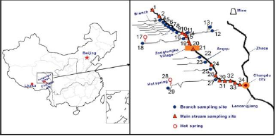
2.1 Distribution of Sampling Sites
A total of 34 sampling sites were set in the main
stream and branches of Angqu River respectively in
normal season (October 2015), dry season (March
2016), flood season (June 2016), based on geo -
environmental conditions (Zhang et al., 2014).
Figure 1 shows the specific sampling sites locations.
Among of them:
(1) Water samp ling sites: 14 sites in the main
stream of Angqu River (No.1, 2, 10, 14, 15, 19, 20,
21, 24, 26, 30, 31, 32, 33, 34). 17 sites in branches
(No. 3, 4, 5, 6, 7, 8, 9, 11, 12, 13, 16, 18, 22, 23, 25,
27, 29). 2 sites in hot springs (No.17, 28).
(2) Solid sampling sites: 1 site of rock (No.21), 2
sites of soil (No.15, 21), 1 site of sediment (No.15).
Figure 1: Map of sampling sites in the Angqu river and
branches.
Note: 1-90km upstream of Angqu estuary, 2-80km upstream of
the estuary, 3-branch(79km upstream of the estuary), 4-
branch(77km upstream of the estuary), 5-branch(76km upstream
of the estuary), 6-branch(74km upstream of the estuary), 7-
branch(73km upstream of the estuary), 8-branch(72km upstream
of the estuary), 9-branch(70km upstream of the estuary), 10-69km
upstream of the estuary, 11-Mangda branch(67km upstream of the
estuary), 12-left branch(5km upstream of Mangdaqu branch), 13-
right branch ditch(5km upstream of Mangdaqu branch), 14-66km
upstream of the estuary, 15- 65.5km upstream of the estuary, 16-
Engdaqu branch(65km upstream of the estuary), 17-hot
spring(Endaqu branch), 18-10 km upstream of the Endaqu
branch(1km upstream of hot spring), 19-64.5km upstream of the
estuary, 20-64km upstream of the estuary, 21-60km upstream of
the estuary, 22-branch(55km upstream of the estuary), 23-
branch(46km upstream of the estuary), 24-45km upstream of the
estuary, 25-Langda branch(34km upstream of the estuary, 26-
29km upst ream of the estuary, 27-Xiebaqu(28km upstream of the
estuary), 28-hot spring(Zhugu Temple), 29-Zhugu T emple karst
water, 30-27km upstream of the estuary, 31-20km upstream of the
estuary,32-10km upstream of the estuary,33-2km upstream of
Angqu estuary,34-Angqu
2.2 Experimental Methods
Inductively coupled plasma-mass spectrometry
(ICP-MS) was used to detect the content of As, Fe,
Cr, Mn in samples by reference to Water quality –
Determination of 65 elements - Inductively Coupled
Plas ma-Mass Spectrometry (HJ 700-2014) and Soil
and sediment-Determination of mercury, arsenic,
selenium, bismuth, antimony-Microwave
dissolution/Atomic Fluorescence Spectrometry (HJ
680-2013). Referring to Solid waste-Extract ion
procedure for leaching to xicity-Horizontal vibration
method (HJ 557-2010), leaching to xicity tests
(Wang et al., 2018; Ning et al., 2012) were
conducted with typical solid samples in the areas of
Angqu River. Firstly, the solid samples were dried at
105℃, then the extractant (pure water) was added at
a solid-liquid ratio of 10:1(L/kg ) and was shaken at
a frequency of 110±10 times/min at room
temperature for 8 hours. The leachate was filtered
with 0.45μm millipore filter after standing for 16
hours, and then tested by ICP-MS.
EFDC, a co mmercia l software, was used to
establish a 3D mathematical model of water sand-
water quality, to simu late and predict changes in
water quality parameters such as arsenic and iron in
the reservoir area after the reservoir established in
Zongtongka Village.
3 RESULTS AND DISCUSSION
3.1 Investigation Results of the Angqu
River Water Quality
The water quality monitoring result of the Angqu
River was shown in Tab le1. During normal season,
the content of As, Fe, Mn and Cr all met the Class
III of the National Standard (GB3838-2002) in all
sampling sites at the main stream except that the
content of Fe was excessive at 0km upstream of
Angqu River estuary (located downstream of
Zongtongka Village). During dry season, the content
of Mn and Cr all met the standard limits of Class III
except that most samplings were excessive of Fe and
some we re excessive of As . During flood season, the
content of As, Mn and Cr all met the standard limits
of Class III o f the Nat ional Standard (GB3838-2002)
except that the content of Fe was excessive in most
samplings.
Study on Site Selection of Water Supply Reservoir at High Geological Background Area along the Angqu River
183
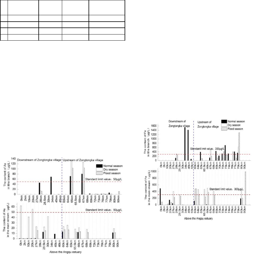
Table 1: Investigation results of the Angqu River water
quality (μg/L).
Normal
season
Dry
season
Flood
season
Class Ⅲ
standard
As
0.4-13.39
17.8-62.0
0.4-17.3
50
Fe
0.0-493.3
5.0-501.7
40.0-487.7
300*
Mn
1.1-30.2
15.6-26.7
7.5-22.7
100*
Cr
0-7.9
1.9-19.2
0-0.3
50
3.2 Variation Features of As, Fe in
Water along the Angqu River
3.2.1 Variation Features of As
Figure 2 shows the detection results of As in
samples collected from the main stream and
branches of Angqu River during three seasons. The
content of As exceeded the Class III of standard for
surface water in two branches upstream of
Zongtongka Village respectively at 67km and 65km
upstream of Angqu estuary. The content of As in
34km upstream of Angqu River estuary (Langda
branch) exceeded the Class III of standard for
surface water downstream of Zongtongka Village.
Figure 2: As content in the main stream and branches of
Angqu River during different seasons (normal, dry, flood
season).
It was known from the analysis of water quality
features in different seasons: the content of As along
Angqu River rose gradually, and obviously rose
after the three branches flowed into during normal
and flood season, which indicated the entrance of
branches would influence the content of As in the
Angqu River. Co mpared results in different seasons,
the As content in the main stream of Angqu River
was lower during flood and normal season than dry
season, which may be due to the As was diluted
caused by large flow.
3.2.2 Variation Features of Fe
The detection results of Fe at the main stream of
Angqu and branches during different seasons were
shown in Figure.3. As can be seen fro m the figure,
most branches and one site in the main stream of
Angqu River were excessive of Fe during normal
season. Most main stream sites and only two
branches were excessive of Fe during dry season.
During flood season, Fe in most main stream sites
and three branches exceeded the standard. In view of
the distribution of Fe content along the river, when
the branch water with a higher Fe content flowed
into the ma in stream, the Fe concentration in the
main stream water did not increase obviously.
Figure 3: Fe content in the main stream and branches of
Angqu River during different seasons (normal, dry, flood
season).
This showed that Fe in the main stream d id not
ma inly orig inate from the in flu x of branches, but
might be caused by local geological conditions.
3.3 Influence of Local Geological
Background on Site Selection of the
Water Reservoir
Result in Table 2. implied that there is a problem of
excessive As and Fe in No.17 and No.28 hot spring
during dry and flood season, and there is much
higher concentration in No.28. According to the
IWEG 2018 - International Workshop on Environment and Geoscience
184
field investigation, it was found that the No.17 hot
spring (Endaqu, located upstream of Zongtongka
Village) water was discharged directly to the branch
(Endaqu branch) 65km upstream of Angqu River
estuary, and the No.28 hot spring (Zhugu Temple
Hot Spring) water was discharged directly to the
branch (Xiebaqu) 28km upstream of the estuary. The
As content in water of the main stream rose
obviously by the influx of Endaqu branch and Xieba
branch to the Angqu River (as shown in Figure 2.).
It suggested that the influx of the branch with h igh
As concentration affected by hot spring (As content
was 50 times of the standard) led to the rise of As
content. However the Fe content in the branch did
not rise obviously (as shown in Figure 3.) with the
influx of hot spring water, mainly due to the
relatively low Fe content (4 times of the standard)
and water quantity of the springs.
Typical roc k samples (Zongtongka Village), soil
samples (Mangda Bridge, Zongtongka Village) and
sediment samples (Endaqu branch) along the Angqu
River were selected to conduct leaching toxicity
tests. Results (as shown in Tab le 3.) suggested that
there was no problem of excessive heavy metals in
the leachate of the rock, while Fe in the leachate of
the soil and sediment were generally exceeded the
standard limit, and the leach ing concentrations of
other metals (As, Mn, Cr) all met the Class III
standard or standard limit. It was known that the
leaching of Fe in the sediment of Angqu River and
the surrounding mountain soil posed a potential
threat to the water quality, and is an important
reason for the excessive content of Fe in the Angqu
River (Liu et al., 2009). It is related to the local
geological background that As and Fe content
exceeded the standard due to no other pollution
sources from surroundings.
Table 2: Heavy metals content in hot spring water (μg/L).
Name of sampling site
As
Fe
Mn
Cr
Dry
season
Flood
season
Dry
season
Flood
season
Dry
season
Flood
season
Dry
season
Flood
season
No.17-hot spring
552.1
494.2
407.7
7.9
<0.12
<0.12
12.0
<0.11
No.28-hot spring
2499
2337
1215
379.9
15.75
55.88
<0.11
<0.11
Class III standard/limit
50
300
100
50
Table 3: Heavy metals content in the leachate of rock, soil and sediment in normal season (μg/L).
As
27.62
3.81
2.19
35.73
50
Fe
276.4
1689.1
353.5
544.1
300*
Mn
4.30
28.29
8.04
13.03
100*
Cr
0.42
3.60
0.59
0.88
50
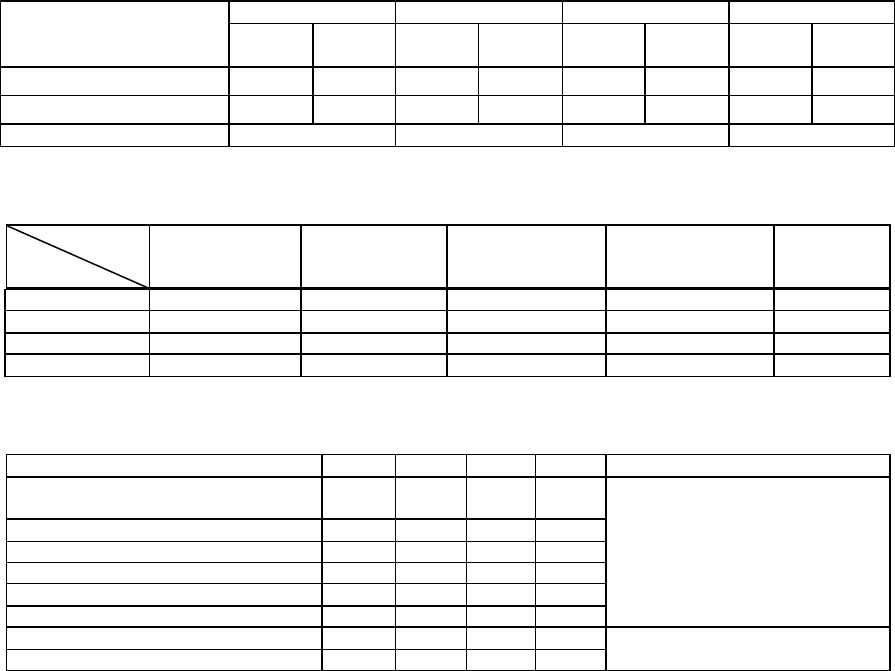
Table 4: Water quality monitoring data at the main stream of Angqu River in M arch,2016 (μg/L).
Sample
Metal
Rock in Zongtongka
Soil in Mangda
Bridge
Soil in Zongtongka
Sediment in Endaqu
branch
Class Ⅲ
standard
Name of sampling site
As
Fe
Mn
Cr
Location
80km upstream of Angqu estuary
(End of Zongtongka reservoir)
19.4
455.0
26.7
16.1
Angqu main stream,
upstream of Zongtongka
69km upstream of Angqu estuary
17.8
411.9
20.4
<4.0
67km upstream of Angqu estuary
21.3
411.4
19.6
16.2
65.5km upstream of Angqu estuary
18.3
467.3
19.5
17.7
64.5km upstream of Angqu estuary
25.5
459.0
21.5
16.2
60km upstream of Angqu estuary
23.3
471.1
19.3
15.3
29km upstream of Angqu estuary
22.3
306.5
15.6
16.0
Angqu main stream, downstream of
Zongtongka
27km upstream of Angqu estuary
23.2
400.7
18.2
19.0
Study on Site Selection of Water Supply Reservoir at High Geological Background Area along the Angqu River
185
3.4 Preliminary Analysis of Site
Selection of the Water Supply
Reservoir in Angqu River
Based on the investigation results above, it could be
seen that the state of water quality upstream of
Zongtongka Village was good overall, which
satisfied the Class III of water quality standard and
the requirements for water source (except Fe during
some seasons). In addition, there had been no
industrial and mining enterprises upstream of
Zongtongka Village, and was rich in natural
vegetation with relatively h igh vegetation coverage.
Therefore the conditions of the water conservation
and sand prevention are pretty good.
The water quality upstream of Zongtongka
Village was affected by nearby hot springs. The
influx of hot spring water highly mineralized with
high content of As and Fe had a significant impact
on the water quality of the Angqu River. As well as
the content of As and Fe in the nearby hot spring
water (No.28) was much higher than that in the hot
springs (No.17) upstream of Zongtongka Village. It
was also indicated by the monitoring data that the
downstream of Zongtongka Village was excessive of
As and Fe, wh ile the water quality had a trend to get
worse along the river (As shown in Table 4.).
In conclusion, the water quality upstream of
Zongtongka was better than downstream. So
the upstream of Zongtongka was the optimal
water source.
3.5 Water Quality Simulation,
Prediction and Countermeasures
The water quality upstream of Zongtongka Village
was good and could serve as the water source.
Sediment adsorption experiment (Peng et al., 2016;
Tang et al., 2015; Ying et al., 2012; Chen et al.,
2008) and research on water quality simulation and
prediction had been conducted to understand the
reservoir water quality after the reservoir established.
The simulat ion parameters referred to the Guoduo
Reservoir at Zhaqu river , whose geological
background conditions and geographic location are
similar to the proposed reservoir. Suspended
sediment’s absorption of As and Fe had been
analyzed by conducting absorption experiment, it
had been indicated that sediment had a better
adsorption of As and Fe, and reached adsorption
equilibriu m within a short time.
The time of adsorption equilibriu m of As and Fe
were 3 hours and 1 hour respectively. And the
equilibriu m time of sediment on Fe is shorter than
As.
The water quality parameters-(distribution
coefficient) of the model was determined by the
combination with the consequences of absorption
experiments and the simulat ion parameters from
Guoduo Reservoir at Zhaqu river. Then the
adsorption, desorption, migration and transfer
processes of As and Fe in the water of reservoir after
the impoundment was simu lated to predict changes
of water quality a long the river by using the
mathe matical model of the 3D sediment water
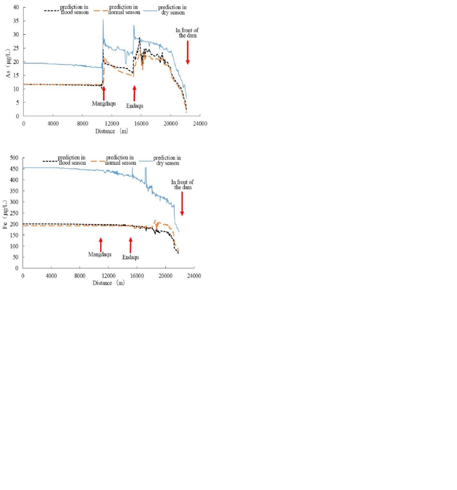
quality in the proposed Zongtongka reservoir. Figure
4 shows the simu lated prediction results which
suggested the As concentrations in the ma in stream
of the reservoir during three water seasons all met
the Class III standard after the proposed Zongtongka
reservoir established. The content of Fe met the
standard during flood season and norma l season. It
was excessive of Fe concentration from the end
reservoir to the 3km upreach of the da m and met the
standard in the reach near the dam during dry season.
For the Zongtongka Reservoir was unbuilt, the
content of As and Fe in water of the Guoduo
reservoir built at the Zhaqu River was used to
validate the model. Compared with the stimulation
results and monitoring data of water quality
variation along Guoduo Reservoir area, the model fit
the observed data.
It had indicated that, after the reservoir
established at Zongtongka Village, the water quality
could meet the Class III standard except for some
local areas. The high Fe content in the dry season of
local areas was mainly related to the local geological
environment. However, the sediments adsorption
would be beneficial to the sedimentation of Fe and
As after the reservoir impounded.
Based on the comprehensive analysis of the
Angqu River water quality and the water quality
simu lated predictions upstream of Zongtongka
Village, it had been clear that upper reach from
Zongtongka Village is the most ideal water source
for Changdu City. At the same time, it had been
recommended to carry out long-term monitoring and
evaluation of water quality safety in the Angqu
River to grasp the pollution characteristics and
IWEG 2018 - International Workshop on Environment and Geoscience
186
pollution changes of the water quality in real time,
and to divert and purify the branches excessive of
As in the reservoir area to ensure the water supply
safety of the proposed reservoir.
Figure 4: The prediction results of variation of As(a) and
Fe(b) along the reservoir in Zongtongka Village.
4 CONCLUSIONS
The water environ ment state of Angqu River had
been investigated and studied, and effects of local
geological background on the selection of water
supply reservoir site had been analyzed. At the same
time, the changes of water quality after the reservoir
established had been simulated and predicted, and
corresponding water quality protection
countermeasures had been put forward. Followed
are mainly conclusions.
The field investigation has indicated that the
Angqu River was excessive of the As and Fe content
while other indicators met the water quality
requirements of water source.
It has been found that the upper reach of
Zongtongka Village is relat ively optimal water
source compared with the Angqu River, based on
the analysis of Angqu water quality and the effects
of local geological background on site election.
According to the adsorption experiments and the
study of water quality simulation and prediction, it is
found that the As content could meet the Class III
standard for surface water in ma in stream of the
proposed Zongtongka reservoir. The Fe
concentration in the main stream of the reservoir
during flood season and normal season could meet
the standard limit for surface water, and water in the
area of 3 km before the dam also met the limit. The
area upstream of Zongtongka Village is an ideal
water source in the region has been verified at the
same time.
It is suggested that carrying out long-term water
quality safety monitoring and evaluation of the
Angqu River to grasp the pollution characteristics
and pollution changes in real time, and diverting and
purifying the springs around the proposed reservoir.
ACKNOWLEDGEMENT
This work was supported by Young Elite Sponsorshi
p Program by CAST (Grant 2015QNRC001), the Na
tional Natural Science Foundation of China(Grants 5
1309019), Statelevel Public Welfare Scientific Rese
arch Institutes Basic Scientific Research Business Pr
oject of China (CKSF2017062/SH).
REFERENCES
Chen Faxing 2016. Numercial Simulation of Water
Quality in Minghu Reservoir Based on EFDC and
Water Quality Prediction. J. Yellow River 1 85-87,137
Chen Zhihe, Fang Hongwei, Chen Minghong 2008.
Experimental study on distribution characteristics of
copper ions adsorbed on the surfaced of sediment
particles. J. Journal of Hydraulic Engineering 5 633-
636
Cho Eunju, Arhonditsis George B, Jeehyeong Khim, et al
2016. Modeling metal-sediment interaction processes.
J. Environmental Modelling & Software 80:159-174
Dava Ciugene, Ciugene 2015. Discussioin on Ecological
Construction and Sustainable Development in
Changdu Area of Tibet. J. China Tibetology 4 90-97
GB3838-2002, Environmental quality standards for
surface water [S]
(a)
(b)
Study on Site Selection of Water Supply Reservoir at High Geological Background Area along the Angqu River
187

HJ 700-2014, Water quality-Determination of 65
elements-Inductively coupled plasma-mass
spectrometry [S].
HJ557-2010,Solid waste-Extraction procedure for
leaching toxicity-Horizontal vibration method [S].
HJ680-2013, Soil and sediment-Determination of mercury,
arsenic, selenium, bismuth, antimony-Microwave
dissolution/Atomic Fluorescence Spectrometry [S].
Huang Jiacong, Qi Lingyan, Gao Junfeng, et al
2017. Risk assessment of hazardous materials loading
into four large lakes in China: A new hydrodynamic
indicator based on EFDC. J. Ecological Indicators 80
23-30
Liu Heng, Cao Yongxu, Zhao Yanlong 2009. Survey on
iron and manganese pollution in reservoir water and
cause analysis. J. Pearl River 3 20-23
Ning Qiuyan, Xu Wanfu, Yu Guihua, et al 2012. Leaching
toxicity of the unfired bricks made by dyestuff-making
wastewater coagulatioin aludge. J. Environmental
Pollution and Control 3 20-23
Peng Chunlan, Jiang Yujiao, Zhang Xinyue 2016.
Discussion on the changes and genesis of water quality
in the reservoir and downstream of the dam before and
after the impoundment of the Three Gorges Reservoir.
J. Express Water Resources&Hydropower Information
11 35-40
Song Jingyi, Fu Kaidao, Su Bin, et al 2013. Spatial
distribution of heavy metal concentrations
and pollution assessment in the bed loads of
the Lancang River System. J. Acta Geographica
Sinica 3 389-397
Tang Xuan, Duan Dandan, Huang Wen, et al 2015.
Distribution and partitioning of heavy metals in
particulate and colloid phases in different kinds of
water in the downstream Pearl River. J. Ecology and
Environment Sciences 12 2017-2021
Wang Feng, Li Rundong, Li Yanlong, et al 2018.
Comparison of different leaching methods for heavy
metal and comprehensive toxicity evaluation. J.
Environmental Science 1 292-299
Ying Yimei, Xu Chunhong, Li Haihua, et al 2012. Studies
on adsorption of arsenic pollutants onto sediments of
the Yellow River using laboratory static experiments. J.
Research of Environmental Sciences 3 352-356
Zhang Jilai, Fu Kaidao, Wang Bo, et al 2014. Assessment
of heavy metal pollution of bed sediment in the
Lancang River. J. Progress in Geography 8 1136-1144
Zhang Qing, Tan Hongbing, Qu Tao, et al 2014. Impacts
of typ ical harmful elements in geothermal water on
river water qualtiy in Tibet. J. Water Resources
Protection 4 23-29
IWEG 2018 - International Workshop on Environment and Geoscience
188
