
Identification and Exploration of Lithologic Traps in
Block M of South Turgay Basin
Linghong Kong
*
, Mingjun Zhang,Yaping Lin and Man Luo
Research institute of petroleum exploration & development, CNPC.
Email: klh@petrochina.com.cn
Keywords: South Turgay Basin, anomalous bodies, global stratigraphic framework model, spectral decomposition
Abstract: The Jurassic formation in block M of South Turgay Basin is located in the gentle slope zone of the rifted
lake basin where structural traps are not developed, so it is important for explorers to find lithologic traps.
They are mainly located in the Jurassic system and the main control factor of forming reservoirs is the
reliability of lithologic traps. The sedimentary characteristics of Jurassic system in this area show that
reservoirs with sands up-dip pinch-out in front of slope zone are formed in formation Doshan in the Middle
Jurassic. The spatial distribution and oil-bearing properties of the anomalous body in Doshan formation
which forms the lithologic trap because of sands up-dip pinch-out are described by the techniques of
automatic interpretation based on the global stratigraphic framework model, sub-volume coherence, S-
Transform of spectral decomposition and low frequency enhancement. This lithologic trap which has
favourable reservoir forming conditions was drilled to prove that it contains industrial oil and gas.
1 OVERVIEW OF THE STUDY
AREA
The South Turgay Basin which is located in the
central part of Kazakhstan and in the transitional
shear zone of the Ural-Tianshan suture is the
Mesozoic fault depression basin above the
Hercynian period. It has experienced the Early-
Middle Jurassic fault depression period, the Late
Jurassic transitional period and the Cretaceous
depression period (Shi et al. 2016; Liu and Jiang,
2013; Zhang et al., 2012; Sun et al., 2008). It is
accompanied by a strike-slip tectonic movement
along the western edge of the basin, forming a near-
north-south Karatau crush-strike-slip fault, creating
the structure pattern of a convergence in the
southeastern and diverging in the northwest of the
basin. The formation and distribution of oil and gas
of the basin is controlled by the tectonic zoning of
the basin (Zheng et al., 2009; Allen et al., 2001;
Kong et al., 2007; Yin et al., 2012) (figure 1). The
exploration of the basin began in the 1960s. It has
been into the high mature -rolling stage of
exploration for 50 years, so it is very difficult for
further to find the large-scale structural oil and gas
reservoirs (Tian et al., 2010; Yin et al., 2011; Sheng
et al., 2014). The current exploration of the basin
focuses on the lithology traps of the depressions and
slopes.
The block M is located in the south of Aryskum
graben and in the context of regional tectonics, the
pattern of fault depression in the east and
overlapping upward in the west are formed. The
block M is the eastward slope on the whole and the
Karatau strike-slip fault is developed in the east.
Drilling results have shown that the lithology
reservoirs in this area are mainly located in the
Middle and Lower Jurassic. They can be divided
into three sets of strata from the bottom to top
(figure 2): the Ablin Formation(J1ab), the Doshan
Formation(J2ds), the Karagansai Formation(J2kr).
The Middle and Lower Jurassic periods correspond
to the lake basin depression. The deep to semi-deep
lake mudstone and source rock were developed in
the J1ab. Based on the deposition of shallow lake,
the delta sediment was developed in the J2ds and the
underwater distributary channel, frontier sand and
beach dam which were beneficial reservoirs were
adjacent to source rocks and easy to form lithology
reservoirs. The J2kr corresponded to a large-scale
flood period. The thick mudstone which was the
effective regional cap rock of J2ds was developed in
the J2kr. It is an effective play of reservoir and cap.
340
Kong, L., Zhang, M., Lin, Y. and Luo, M.
Identification and Exploration of Lithologic Traps in Block M of South Turgay Basin.
In Proceedings of the International Workshop on Environment and Geoscience (IWEG 2018), pages 340-343
ISBN: 978-989-758-342-1
Copyright © 2018 by SCITEPRESS – Science and Technology Publications, Lda. All rights reserved
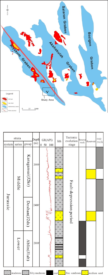
Figure 1: Structural framework and oil and gas distribution
map of the South Turgay Basin.
Figure 2: Jurassic geologic column of block M.
2 CHARACTERIZATION OF
LITHOLOGIC TRAPS
Firstly, the stratigraphic model is calculated from the
post-stack seismic data volume by using the
automatic seismic interpretation method based on
the global stratigraphic framework model. Then, the
horizons are extracted from the model and the
seismic attributes are calculated. Finally, the global
search and tracking of the anomalous body and the
research of sedimentary evolution are made by using
the seismic attributes of many horizons.
On the basis of considering the seismic reflection
characteristics, stratigraphic sedimentary global
consistency, sedimentary thickness, formation
inheritance and other integrated geophysical factors,
the automatic seismic interpretation method based
on the global stratigraphic framework model regards
3D seismic data as the show of the present
underground geological bodies. The global
stratigraphic framework model is established based
on the seismic geologic information contained in the
whole 3D seismic data and the global isochronous
deposition sequence. And then the optimal
stratigraphic model is selected in a large number of
possible geological frameworks by the cost function
based on seismic data similarity and geological
consistency. On this basis, the application of drilling
data, seismic data, multi-attribute and multi-
directional integrated interpretation mode can
greatly improve the interpretation accuracy of the
structure. The isomorphic stratigraphic model, which
contains all the geological information such as
tectonic deformation, sedimentary sequence,
sedimentary evolution and so on, can be used to
reconstruct palaeogeomorphology and study the
restoration and evolution of the sedimentary history.
The realization process mainly includes two steps:
first, a model grid consistent with the stratigraphic
model is calculated based on seismic data. The
stratigraphic model is calculated by using the cost
function minimization algorithm and connects the
seismic samples according to the wavelet similarity
and the relevant distance. This process automatically
tracks each horizon in the seismic data to constrain
the grid and a relative geological age value is
calculated at each grid point. Second, the model is
refined by modifying the connection relationship
between the automatic tracking horizons. Each
operation has an effect on the node connection
relationship in the model grid. Under the preview
function, the quality of the model compared to the
original seismic data can be evaluated until an
optimized model is obtained.
Identification and Exploration of Lithologic Traps in Block M of South Turgay Basin
341
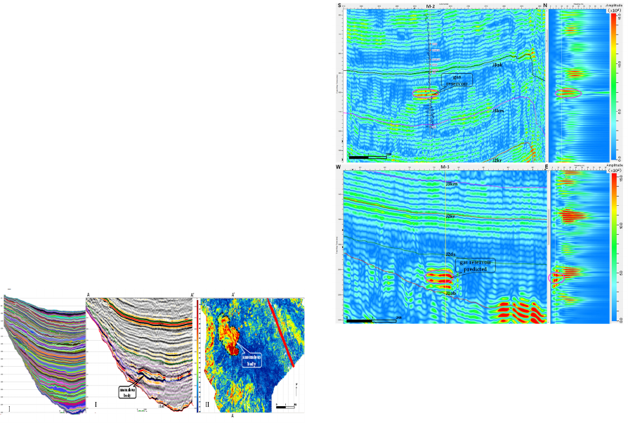
Based on the pre-stack migration seismic data of
block M, the Jurassic stratigraphic model was
established by this method (figure 3-I). Then, 200
horizons were extracted from the J2ds stratigraphic
model and the corresponding RMS amplitude and
dessert attributes were calculated. The horizons
extracted by this method were the isochronous
surface (figure 3-II) and better than the time slices,
the slices along horizons and the stratigraphic slices,
because these three kinds of slices cannot be the
isochronous due to the impaction of the attitude of
stratum and the structural relief. It was concluded
that the large-scale anomalous body was developed
on the slope of J2ds formation by analysing the
sedimentary evolution according to the animation of
the dessert attributes corresponding to 200 horizons
(figure 3-III).The anomalous body was isolated
because its western upside is obliquely pointed out.
The seismic amplitude of anomalous body was
significantly enhanced and the frequency was lower.
And then the top and bottom surfaces of the
anomalous body were tracked by the three-
dimensional visualization of the automatic tracking
technology and its time isopach map was drawn. The
plane of this anomaly which covers 13 square-
kilometers is oval in the direction north-south. It is
about 6300 meters long from north to south, and
3770 meters in width from east to west. On the
whole, it is thicker in the east side than that in the
west side and the maximum thickness of main part is
up to 120ms (about 180 meters).
Figure 3: Jurassic stratigraphic model(I) and plane
characteristics of J
2
ds anomalous body of block M(The
pink lines in II is the part horizons extracted from I. III is
the dessert attribute of the blue horizon in II).
3 HYDROCARBON DETECTION
This study has applied the spectral decomposition of
four algorithms, such as Discrete Fourier Transform
(DFT), Continuous Wavelet Transform (CWT),
Time-Frequency Continuous Wavelet Transform
(TFCWT) and S-Transform. The principle of the
algorithm and the actual effect show the S-
Transform method is optimal. The spectral
decomposition profiles of the wells M-2 and M-3 are
shown in figure 4, where the left side is the spectral
decomposition profile of the wells with the gamma
curve projected and the right side is the spectrum
decomposition profile of the seismic trace at the well
point. In figure 4, there are strongest energy of 20-
25Hz and weak energy of 40Hz or more at the gas
zone of well M-2. The anomalous body of J2ds
deployed the new well M-3 is predicted gas zone
where the frequency is concentrated at 5-15Hz and
the high frequency attenuation is obvious.
Figure 4:.Spectral decomposition profiles through wells
M-2 and M-3.
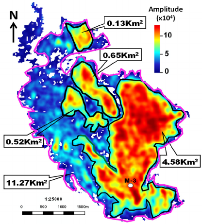
Based on the spectrum decomposition 10Hz
seismic data, the top and bottom surface of
anomalous body were tracked firstly by the three-
dimensional automatic tracking technology. Then its
inner RMS amplitude was extracted, range more
than 1.0x10
5
was selected and sculptured. Gas-
bearing area of about 11.27 square kilometres was
predicted (the pink line range in figure 4) and a
higher degree of gas saturation area with about 100
meters thickness was 5.88 square kilometres (the
black line range in figure 5).Well M-3 was deployed
in conjunction with the structural features of the J2ds
layer in the range of high gas saturation of the J2ds
anomalous body. This well was drilled in 2016 and
tested in the J2ds layer for obtaining high-yield oil
and gas flows. This well is the first discovery well
for the lithological trap in the J2ds formation,
located in the southern Turgay Basin. The above
IWEG 2018 - International Workshop on Environment and Geoscience
342
technical approach is also promoted in the
lithological traps of other blocks in the basin.
Figure 5: 10Hz seismic RMS amplitude of J2ds anomalous
body of block M.
4 CONCLUSIONS
By using automatic interpretation technology based
on global stratigraphic framework model, J2ds
anomalous body in block M is identified, which is an
up-dip pinch-out lithological trap on the slope. Its
area is about 13 square kilometres with 180 meters
maximum thickness of main part. Then, the spectral
decomposition technique of S-Transform method is
selected for spectrum decomposition. According to
the dynamic characteristics of "low frequency
enhancement, high frequency attenuation",
hydrocarbon-bearing possibility of lithological trap
was predicted based on the spectrum decomposition
10Hz seismic data. The predicted gas-bearing area is
about 11.27 square kilometres and a higher degree of
gas saturation area is around 5.88 square kilometres.
Based on 3D visualization of lithological trap
and accumulation condition analysis, well M-3 has
been deployed for obtaining high-yield gas flow.
The first scale breakthrough of lithological reservoir
was realized in block M and a new prospect of
lithological reservoir exploration in this area was
opened up. At the same time, the series of
technology has been widely used in lithological
exploration in other areas of the basin and achieved
good practice results.
ACKNOWLEDGMENT
The authors would like to thank the "Special and
Significant Project of National Science and
Technology: Global oil and gas resources
assessment and constituencies with research" and
CNPC project to support this study, and the fund
numbers are 2016ZX05029-005 and 2016D-4301.
REFERENCES
Allen M B, Alsop G I and Zhemchuzhnikov V G 2001
Dome and basin refolding and transpressive inversion
along the Karatau Fault System, southern Kazakstan
Journal of Geological Society 158(1) 83-95
Kong Xiangyu, Yin Jinyin and Zhang Faqiang 2007 Oil-
gas Geological Features and its Exploration Potential in
South Turgay Basin, Kazakstan Lithological
Reservoirs 19(3) 49-53
Liu Jingdong and Jiang Youlu 2013 Effect of Structural
Inversion on Reservoir Forming in A
Depression,Kazakhstan Geological Science and
Technology Information 32(3) 75-79
Sheng Xiaofeng, Zhang Mingjun and Guo Jianjun 2014
Play Division and Analysis of Resource Potential of
South Turgay Basin Earth Science Frontiers 21(3)
166-171
Shi Juye, Jin Zhijun and Fan Tailiang 2016 Sequence
Stratigraphy Characteristics and Filling Evolution
Models in the North of Aryskum Depression,South
TurgayBasin Geological Science and Technology
Information 35(6) 70-76
Sun Tie-jun, Li Qinghua and Wang Li 2008 Study on
structural feature of south Turgay basin, Kazakhstan
Oil Geophysical Prospecting 43(Supplement 2) 165-
167
Tian Zuoji, Xu Zhiqiang and Zheng Junzhang 2010
Petroleum Geology and Accumulation in Aryskum
Depression in Turgay Basin XINJIANG Petroleum
Geology 31(1) 108-109
Yin Wei, Fan Zifen and Zheng Junzhang 2012
Characteristics of Strike-lipInversion Structures of the
Karatau Fault and their Petroleum Geological
Significances in the South Turgay Basin, Kazakhstan
Petroleum Science 9(1) 444-454
Yin Wei, Zhang Mingjun and Kong Linghong 2011
Lithological Reservoirs in Block A in the South Turgay
Basin, Kazakhstan Petroleum Exploration and
Development 38(5) 570-575
Zhang Chaofu, Chen Anding and Pu Yu’e 2012 Structural
Dynamics Analysis of Aryskum Depression in South
Turgay Basin of Kazakhstan XINJIANG Petroleum
Geology 33(1) 127-129
Zheng Junzhang, Zhou Haiyan and Huang Xianxiong
2009 Characteristics of petroleum geology and analysis
of exploration potential in Kazakstan China Petroleum
Exploration 14 (2) 80-86.
Identification and Exploration of Lithologic Traps in Block M of South Turgay Basin
343
