
Electrical Resistivity Structure of Changbai Volcanic Mountain:
Results from Magnetotelluric Exploration Methods
Gengen Qiu
*
, Hui Fang, Jie Zhang, Fagen Pei, Qingyin Lv and Yan Peng
Institute of Geophysical and Geochemical Exploration, Chinese Academy of Geological Sciences, Langfang, Hebei, China
Email:qiugengen@igge.cn
Keywords:
Magnetotelluric, Changbai Mountain, magma chamber
Abstract: To address the foreign media’s comments that the Tianchi Volcano in Changbai Mountain is likely to erupt
in the near future, we collected a magnetotelluric (MT) observation profile approximately 120 km in length
in the area to detect the deep electrical structures of magma chamber. Because electromagnetic noise from
an unknown source is very strong in the research area, we used remote-referencing and robust processing,
rhoplus analysis, impedance tensor decomposition, and a mutual approximate calculating method between
apparent resistivity and phase for MT data processing. These techniques resulted in relatively reliable
electromagnetic response data in the strong electromagnetic noise area. The results show that there is a clear
magma channel beneath Tianchi Volcano, at a depth of approximately 10 km. An obvious abnormal body of
low resistance, where resistivity is less than 10 Ω•m connects with the magma channel at 7 km deep and
north of the existing crater, suggesting a developing magma chamber in the shallow surface. There are two
nearly vertical low resistivity zones at 7-17 km in depth, one between stations C07-C09 and the other
between stations C04-C05, that connect directly to the low resistance body directly; these low resistivity
zones are likely active fault zones. Crustal low resistivity anomaly bodies are widely developed at depths of
13 – 30 km about 20 km south of Tianchi Volcano, suggesting an active magma chamber. The MT sounding
method results indicate that Changbai Mountain has a high risk of volcanic eruption, and the MT method
performed well detecting the state of current volcanism.
1 INTRODUCTION
In 2012, Taniguchi Hiroshi stated that the
probability of a volcanic eruption at Changbai
Mountain was 99% over the next 20 years based on
a "3-11" earthquake that occurred in 2011. To
address the foreign scholars’ claims that Changbai
Mountain volcano may erupt in coming years,
China's Changbai Mountain Administrative
Committee official responded based on data from
the China Earthquake Administration, the
Seismological Bureau of Jilin Province. The Tianchi
Volcano monitoring station was established at
Changbai Mountain in 1997, and all observations
since then have indicated that Changbai Mountain
shows no active volcanism. Although the most
recent eruption of the Changbai Mountain volcano
remains unconfirmed, the active period of the
Northeast Asian geological plate has attracted the
attention of many scientists.
Changbai Mountain is located at the border of
northeast China and North Korea. The middle of the
crater is Tianchi Lake, with half belonging to China
and the remaining half belonging to North Korea.
The water surface is 2150 m above sea level and the
average water depth is 204 meters. It is the deepest
lake in China and the border lake between China and
Korea; its storage capacity is more than 2 billion
cubic meters. Tianchi Volcano at Changbai
Mountain is the most comprehensive Cenozoic
composite volcano preserved in China (Liu et al.,
1995). In geological structure, Changbai Mountain
is located above the deep subduction zone of the
Western Pacific Ocean and a series of network faults
composed of NE and NW faults are developed in the
area. There have been several eruptions of this
volcano in history, with three credible volcanic
eruptions in 1668, 1702 and 1903 (Jin and Xi,
1994). Changbai Mountain is one has some of the
most intense Quaternary volcanic activity in China
344
Qiu, G., Fang, H., Zhang, J., Pei, F., Lv, Q. and Peng, Y.
Electrical Resistivity Structure of Changbai Volcanic Mountain - Results from Magnetotelluric Exploration Methods.
In Proceedings of the International Workshop on Environment and Geoscience (IWEG 2018), pages 344-352
ISBN: 978-989-758-342-1
Copyright © 2018 by SCITEPRESS – Science and Technology Publications, Lda. All rights reserved
and is also one of the most dangerous volcanoes in
recent years in China (Liu et al., 1995).
Because magma has clear characteristics of low
resistance, magnetotelluric (MT) exploration in the
volcanic area can provide important constraints on
volcanism. The MT sounding method is sensitive to
low resistivity structures and is an important method
for deep exploration. It has been widely applied in
deep structure detection and resource exploration
(Jin et al., 2010; Wei, 2002). Tang Ji and others
completed five umbrella lines and one North-West
line around Changbai crater and nearby areas. Sixty-
one stations were installed for broadband
magnetotelluric sounding data, and their detection
results showed that at Changbai Mountain Lake and
the north and east regions, there is very low
resistivity at depths of about 12 km; the resistivity of
abnormal body is ten to dozens of Ω•m, indicating a
probable crustal magma chamber (Tang and Liu,
1997; Tang and Li, 2001; Tang et al., 1999). The
purpose of this study is to investigate underground
volcanic magma chamber system and electrical
characteristics of the crust and upper mantle to
provide a geophysical basis for hazard prediction
and disaster evaluation of volcanic eruptions.
2 DATA ACQUISITION
Figure 1: Distribution of MT stations at the Tianchi
Volcanic area at Changbaishan Mountain. The center of
the survey line is Tianchi Lake. The length of the
measuring line is approximately 120 km.
Changbai Mountain scenic area is a key 5A level
tourist attraction in China. With the development
and utilization of the scenic area, various large
electromagnetic interference sources are spread
across the study area. Therefore, data acquisition
and data processing were two major key technical
problems for this project. Based on prior working
characterizing the geological deep structures in the
Tianchi Volcanic Area of Changbai Mountain, the
area shows two dimensional structures at NW and
NNW (Tang et al., 1999; Li et al., 1995). There are
also three dimensional anomalous bodies
corresponding to the regional tectonic background.
Most of the work area is covered by virgin forest ,
vegetation flourishes, and the terrain is undulating;
therefore, it is impossible to arrange a straight line
survey. For the convenience of comparative analysis
to the results from previous studies, we designed one
north-easterly MT observational profile with a
length of 120 km (Figure 1). Forty-two stations were
arranged along the line for broadband MT and long-
period MT measurements at a spacing interval of
about 2.5 km. For the strong electromagnetic noise,
wide frequency and long period data were acquired
simultaneously, which improves the data quality of
the low frequency signal
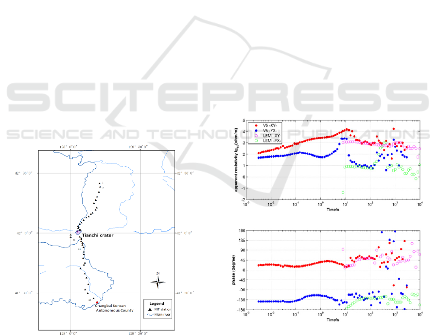
Figure 2: Magnetotelluric sounding curves for station No.
C03. The closed points represent observation data
acquired using the wide-band magnetotelluric sounding
instrument MTU-5A/P, and open symbols represent the
observation data acquired using the long period
magnetotelluric sounding instrument LEMI417M.
Electrical Resistivity Structure of Changbai Volcanic Mountain - Results from Magnetotelluric Exploration Methods
345
Changbai Mountain scenic area is a key 5A level
tourist attraction in China. With the development
and utilization of the scenic area, various large
electromagnetic interference sources are spread
across the study area. Therefore, data acquisition
and data processing were two major key technical
problems for this project. Based on prior working
characterizing the geological deep structures in the
Tianchi Volcanic Area of Changbai Mountain, the
area shows two dimensional structures at NW and
NNW (Tang et al., 1999; Li et al., 1995). There are
also three dimensional anomalous bodies
corresponding to the regional tectonic background.
Most of the work area is covered by virgin forest ,
vegetation flourishes, and the terrain is undulating;
therefore, it is impossible to arrange a straight line
survey. For the convenience of comparative analysis
to the results from previous studies, we designed one
north-easterly MT observational profile with a
length of 120 km (Figure 1). Forty-two stations were
arranged along the line for broadband MT and long-
period MT measurements at a spacing interval of
about 2.5 km. For the strong electromagnetic noise,
wide frequency and long period data were acquired
simultaneously, which improves the data quality of
the low frequency signal.
At each station, an induction type MTU - 5p
broadband MT sounding instrument and flux-gate
type LEMI417M MT sounding instrument were
deployed for combined observations. Usually, the
low frequency signal obtained using the long period
instrument is better than the wide-band MT
sounding instrument (Ye et al., 2013). The
observational frequency range of the broadband MT
instrument is 320-1/1000Hz, and the range of the
long period MT sounding is 1/500-1/10000Hz. The
data acquisition time for each wide-band MT station
was 30 hours, while the data acquisition time for the
long period MT station was 90 hours. Figure 2
shows the MT sounding response data for station
No.C03, where both sets of instruments were
deployed. The curve quality in the low frequency
section, acquired by LEMI417M, is better than that
of MTU-5P. With the combined observations from
two sets of instruments at the same station, the data
quality in the low frequency section can be
improved.
3 DATA PROCESSING
During field data collection, we tested consistency
with two mechanisms and repeated measurements to
control data quality. Changbai Mountain is located
at the border of northeast China and North Korea,
where there is strong electromagnetic noise. Reliable
electromagnetic response data was obtained after
remote-reference and robust processing, rhoplus
analysis, impedance tensor decomposition and
applying a method for mutual approximate
calculations between apparent resistivity and phase.
3.1 Remote Reference Technology
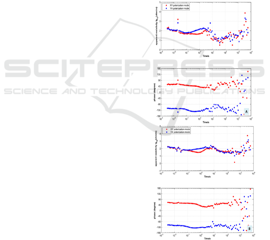
(a)
(b)
Figure 3: Data from station No.C14 before (a) and
after (b) processing by remote reference technology.
IWEG 2018 - International Workshop on Environment and Geoscience
346
Remote reference technology is based on the
principle that the magnetic field signal changes little
at over a short time in a certain range, but the noise
between the measurement and reference stations is
generally unrelated over a certain distance.
Therefore, the method has the effect of suppressing
interference (Yan and Hu, 1998; Edwards and Hastie,
1997). Due to the strong electromagnetic noise in
the work area, we chose a flat terrain with little
noise 40 km away from the working area to build a
long-term reference station during field data
collection. All station data were processed by
magnetic remote reference technology, and the data
quality from most stations was improved after
reference processing. Figure 3 compares the results
collected at station No.C14 before and after
processing by remote reference technology. It is
clear that remote reference processing technology in
Changbai Volcanic Mountain has a certain
suppression effect on electromagnetic noise.
3.2 Static Shift Correction
The additional electric field produced by the
accumulation of charge around local inhomogeneous
bodies usually results in an offset in the overall
curves, which easily produces false geological
anomalies if the curves are uncorrected. In the case
of transverse homogeneous media, the high
frequency segments of two apparent resistivity
curves at one station should have consistent data
values according to the principle of adjacent station
similarity and regional similarity. The high
frequency section of the apparent resistivity curve of
an adjacent station should be almost identical (Chen
et al., 2004; Weidelt and Kaikkonen, 1994; deGroot-
Hedlin, 1991; Zhang et al., 2015). Using a unified
analysis of all stations in the work area, a manual
static shift correction was made to the apparent
resistivity curve based on the static shift having a
great influence on apparent resistivity and little
influence on phase.
3.3 Mutual Approximate Calculation
Method between Apparent
Resistivity and Phase
Because the MT impedance is the minimum phase
response function in one-dimensional media, for the
minimum phase response function, the relationship
between amplitude and phase angle is provided from
the Hilbert transform formula (Fu, 1983; Fu, 198)
lg ( )
1
()
g
f
dg
fg
θ
π
∞
−∞
=−
−
∫
Z
(1)
The approximate formula can be obtained from:
lg
()
44lg
T
d
d
ρ
ππ
θω
ω
≈+
(2)
Concurrently, the following relationship can be
obtained:
lg
4
1
lg
T
d
d
ρ
θ
ωπ
=−
(3)
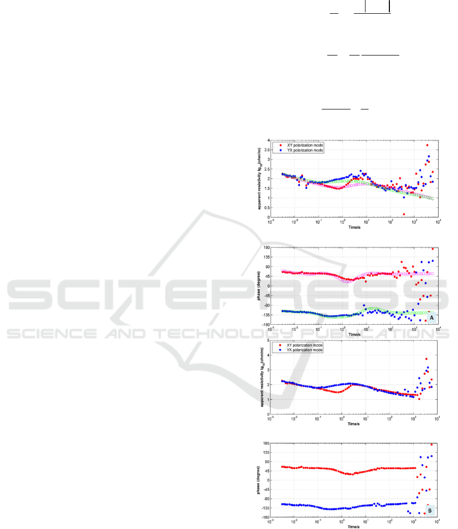
Figure 4: Results for station No.C14 based on the mutual
approximate calculation method between apparent
resistivity and phase curves. As shown, the quality of the
low frequency signal is poor for strong electromagnetic
noise. (a) Measured curves and calculated theoretical
curves and (b) results for station No.C14 after correction.
Electrical Resistivity Structure of Changbai Volcanic Mountain - Results from Magnetotelluric Exploration Methods
347
The apparent resistivity and phase curves can be
calculated using Equations 1-3, and some noise
influence can be corrected with this method. Figure
4 shows the processing results for station No.C14
based on the apparent resistivity and phase mutual
calculation technology method. The curve with open
symbols indicates the results calculated using the
trend in apparent resistivity and phase data. As
shown in Figure 4(b), the MT data acquired is closer
to the theoretical data when after modifying the
apparent resistivity and phase data at a noise
frequency while referencing the theoretical
calculations value.
3.4 Other Processing Techniques
In addition to the described methods, there are
additional advanced processing technologies, such
as robust processing, rhoplus analysis, impedance
tensor decomposition and others (Egbert and Booker,
1986; Chave et al., 1987). We ultimately obtained
relatively reliable electromagnetic response data in
the strong electromagnetic noise area using these
different techniques.
4 DATA ANALYSIS AND
QUALITATIVE EXPLANATION
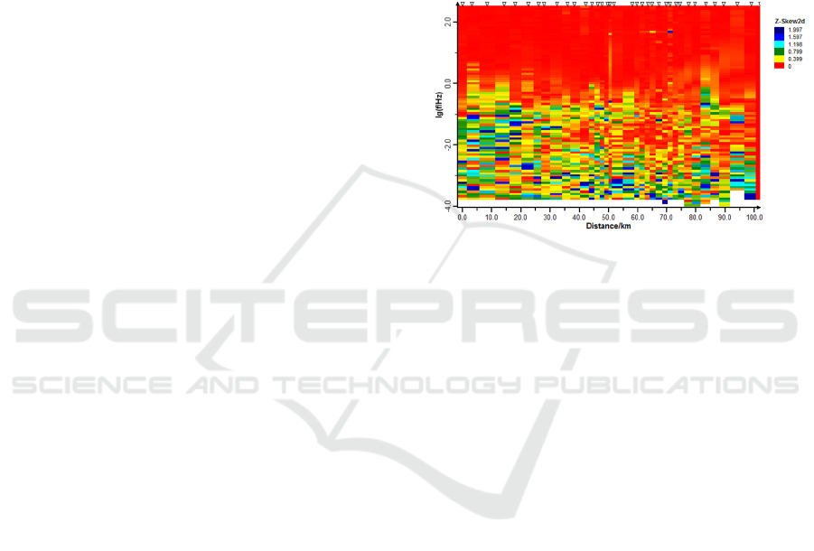
A qualitative estimate of underground electrical
structure in the Tianchi Volcanic area was obtained
using 2D skewness and the analysis of the real
induction vector. The profile was generally
characterized using the 2D structure. The tectonic
direction is primarily northwest. In addition, there is
a 3D low resistivity body localized at shallow and
deep depths.
4.1 Analysis of Two-Dimensional
Characteristics
The two-dimensional deviation S (skewness) of the
MT sounding impedance is a parameter reflecting
the 2D dimension characteristics (Chen and Wang,
1990). For one dimension and the ideal two-
dimensional structure, S=0. Generally speaking,
smaller S values results in a more two-dimensional
underground medium. It is generally believed that
when the S value is less than 0.3 ~ 0.4, the
underground structure can be considered a two-
dimensional feature. Finally, S values greater than
0.5 indicate a three-dimensional medium in the
corresponding depth underground. The MT result
data after editing was used to calculate skewness
along the profile (Figure 5). As shown, most of the
stations along the profile show 2D structure
characteristics in shallow space and strong three-
dimensional characteristics at depth. Affected by
strong electromagnetic noise, the low frequency
skewness may be influenced and unreliable.
Figure 5: Analysis of 2D skewness along the observation
profile. Most stations show 2D structure characteristics at
shallow depths and three-dimensional characteristics
deeper. The 2D skewness value is larger at low frequency
(less than 0.1 Hz), which is likely to be affected by noise
and unreliable.
4.2 Analysis of Two-Dimensional
Tectonic Direction
Due to the continuous subduction of the Western
Pacific plate toward mainland China, Northeast
China has been squeezed. The direction of
maximum principal compressive stress in the study
area is NEE - SWW, and the main fault shows strike
slip movement. The results from satellite
photographs and gravitational field interpretation
show that a group of NW westward faults are
distributed parallel at the Tianchi volcanic crater and
its vicinity (Li et al., 2006). Groom and Bailey
proposed the tensor decomposition theory to manage
the local surface current distortion near the surface,
which is called GB decomposition. The theory
decomposes the impedance tensor into a distortion
tensor and regional two-dimensional tensor. This
restores the undistorted region two-dimensional
impedance tensor data, providing the regional
tectonic direction angle, and solving the distortion
factors, such as shear and distortion in the local
distortion effect (McNeice and Jones, 2001). In this
study, the method for impedance tensor GB
IWEG 2018 - International Workshop on Environment and Geoscience
348
decomposition was used to analyze all station
tectonic trends. Figure 6 is a statistical analysis
diagram of tectonic trend showing that the tectonic
trend for most stations is primarily northwest.
Figure 6: Analysis of the 2D tectonic direction using the
impedance tensor GB decomposition method.
4.3 Induction Vector Analysis
The induction vector for MT sounding was obtained
through the transfer function of the magnetic field.
The induction vector is an important vector
constructed by tilting data. It plays an important role
in delineating low resistivity anomaly bodies and
analyzing structural trends and deep dimensional
characteristics. Its greatest advantage is that it can
provide lateral electrical information about the
corresponding depth below, which is mainly used to
reflect large scale structural features. In addition, the
magnetic field is almost unaffected by local
distortion, and there are no static MT curve shifts.
The induction vector is divided into the real
induction vector and virtual induction vector. The
real induction vector has been widely recognized
and applied because of its clear directivity and
stability. In this study, the direction of the induction
vector is directed to high resistance. If the
underground resistivity varies with depth alone
without lateral variation (one dimensional medium),
the magnetic induction vector is zero.
According to the distribution map of induction
vectors at different frequencies, the approximate
position and distribution range of the
inhomogeneous medium in the underground
medium can be determined. The relevant
relationship is that lower frequencies correspond to
deeper reactions. Due to serious electromagnetic
noise in the work area, the induction vector analysis
in this study can only analyze the characteristics of
the macroscopic electrical change. Figure 7 shows
the distribution of real induction vectors along the
observed profile, in the map upward direction
towards west.
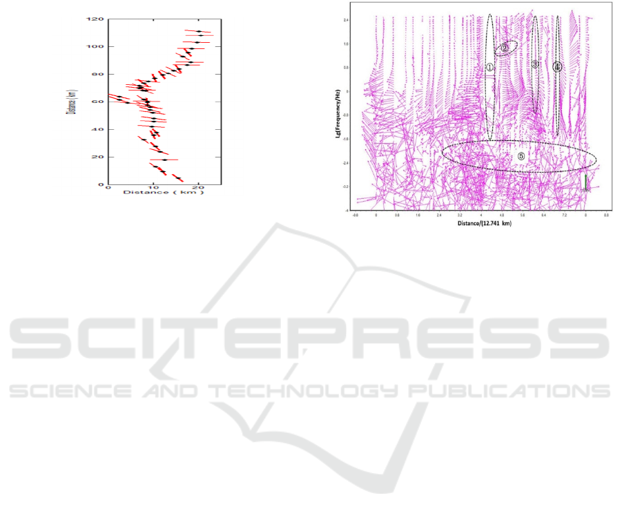
Figure 7: Analysis of the real induction vector; here, up
indicates west. In this paper, the direction of the induction
vector is directed to high resistance. The whole profile
contains five abnormal zones with low resistivity.
From the regular direction of the real induction
vector, from shallow to deep, the whole profile
contains five abnormal zones with low resistivity.
The No.1 low resistivity zone is located at the
bottom of the Tianchi Volcano and below, and the
real induction vectors on both sides are all away
from the direction of the crater. This direction may
represent the Tianchi water body and magma
channel. The No.2 low resistivity zone is located in
the north direction of the Tianchi volcanic crater.
There is a local solid induction vector pointing
northwest, indicating that there is a local low
resistivity anomaly in the southeast direction. The
No.3 low resistivity zone is located between stations
C07 and C09, which is also located near the
Changbai Mountain gate. From the morphology of
the real induction vector, the anomalous area is
approximately vertical. The No.4 low resistance
zone is located between stations C04 and C05, and
is also an approximately vertical strip. As the
frequency decreases, the real induction vector begins
to change, and gradually loses obvious regularity.
The No.5 low resistivity zone is located in the deep
part of the earth's crust. The real vector direction
deviates from the position 20 km south of Tianchi
Volcano, suggesting that the range of the deep and
low resistance abnormal body is large, and the
anomaly area may correspond to a deep magma
capsule. With a further reduction in frequency, the
Electrical Resistivity Structure of Changbai Volcanic Mountain - Results from Magnetotelluric Exploration Methods
349
direction of the real induction vector becomes
disordered and its directivity may be influenced by
strong electromagnetic noise.
5 ANALYSIS OF 2D INVERSION
RESULTS
According to direction of the profile, we can obtain
corresponding accurate TE and TM polarization
mode data by rotating the impedance tensor -90
degrees. A large body of research has shown that a
more accurate inversion result is usually obtained
using the TM polarization mode for the two-
dimensional inversion. Especially in complex
geological conditions, the inversion results from the
TM polarization mode are more reliable than other
inversion results using other polarization mode data
(Dong et al., 2012; Cai and Chen, 2010; Rodi and
Mackie, 2001). The two-dimensional electrical
structure model for the Changbai Mountain igneous
area is obtained through nonlinear conjugate
gradient two-dimensional inversion and
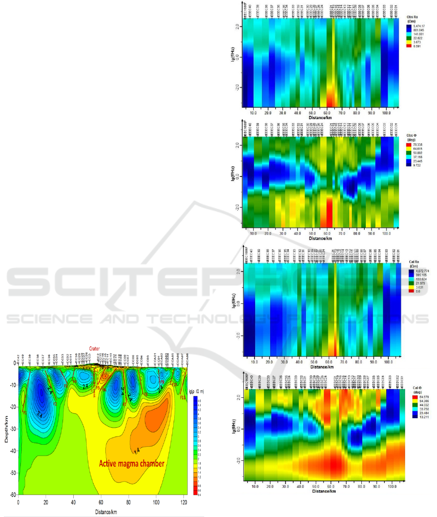
regularization "L curve" factor analysis (Figure 8).
Figure 9 shows the apparent resistivity and phase of
the inversion result fitting. As shown, the calculated
values of the model are in good agreement with the
observed values, and the inversion results are more
reliable.
Figure 8: MT 2D inversion result for the volcanic area at
Changbai Mountain. From the diagram, there are clear low
resistivity anomalies below the Changbai Mountain
volcanoes.
Figure 9: Fitting the inversion result. The calculated
values of the forward model are in good agreement with
the observed values, and the inversion result is reliable.
Note that the left side shows the apparent resistivity map
and right side shows the phase map. The top panels are
observed data, and bottom panels are the calculated values
from the 2D inversion result model.
IWEG 2018 - International Workshop on Environment and Geoscience
350

From the two-dimensional inversion results in
Figure 8, there are clear low resistivity bodies and
electrical gradient zones at depth along the profile,
which correspond to low resistivity abnormal bodies
and fault structures at different depths. Because
Tianchi Volcano at Changbai Mountain is located on
the subduction zone of the Western Pacific Ocean,
and is affected by the compression of the Western
Pacific plate, the subduction produces tension in the
back arc area, and a series of northern oblique faults
developed near the shallow surface of the working
area. According to the characteristics of large
variation gradient and dense contour line, 11 fracture
structures are deduced along the profile. Most of the
shallow surface of the working area is covered by
volcanic debris and Quaternary sediments, which are
characterized by low resistance in the inversion
results. At depth (~20 km), the profile is
characterized by low resistance in the middle region
and high resistance at the south and north areas. The
high resistivity body corresponds to the relatively
high deep resistivity of the crystalline matrix rock
mass, and the middle low resistance corresponds to
the magma channel and the low resistivity anomaly
body. The magma channel located beneath Tianchi
Volcano is an erect structure and closed at about 10
km. At the bottom of the crater, the position
approximately 7 km north shows a clearly abnormal
body of low resistance, resistivity < 10Ω•m, which
connects with the magma channel. Based on these
characteristics, we propose that it may be a
developing magma chamber in the shallow surface.
The abnormal regions between C07 and C09 stations
and between C04 and C05 stations show two clear
nearly vertical low resistivity zones at a depth of
about 7 – 17 km, directly connecting with the below
low resistance body, suggesting that the low
resistivity zone is an active fault zone. With
increasing depth, the crust low resistivity anomaly
bodies are widely developed at depths of 13 – 30 km
approximately 20 km south of Tianchi Volcano,
suggesting that it may be active magma chamber.
There have been differing opinions about the
formation mechanism of volcanoes in northeast
China. A variety of viewpoints have been proposed
by prior researchers, and Tang Ji and others believe
that the modern volcanic activity in the northeast
region is closely related to the dewatering of the
subduction plate of the Western Pacific plate (Hu et
al., 2007; Tang et al., 2006). From the two-
dimensional inversion result model presented in this
study, we can see that the eruption of Changbai
Mountain volcano is closely related to the Western
Pacific plate.
6 CONCLUSIONS
Evaluating the possibility of an eruption of the
Changbai Mountain Tianchi Volcano has become an
important research topic in recent years. In this
study, the MT sounding method was applied to
detect deep electrical structures at Changbai
Mountain, and a nearly north-south observation
profile was surveyed across Tianchi Volcano. A
two-dimensional electrical structure model was
constructed, and the following conclusions obtained.
The electrical resistivity structure of Changbai
Mountain clearly shows the presence of a magma
channel beneath Tianchi Volcano; the magma
channel is closed at a depth of 10 km.
There is an obvious abnormal body of low
resistance, resistivity < 10Ω•m, which connects to
the magma channel. It lies about 7 km north from
the bottom of the crater, suggesting that it may be a
developing magma chamber in the shallow surface.
There are clearly two nearly vertical low
resistivity zones at a depth of 7 - 17 km located
between stations C07 and C09 and between stations
C04 and C05, directly connecting with the low
resistance body, suggesting that these low resistivity
zones are active fault zones.
With increasing depth, the crust low resistivity
anomaly bodies are widely developed at depths of
13 – 30 km approximately 20 km south of Tianchi
Volcano, suggesting that it may be an active magma
chamber.
A number of fault structures have developed in
the working area. According to the electrical
resistivity structure along the profile, 11 fracture
structures were deduced. Due to the extrusion
influence of the Western Pacific plate, a series of
extensional fracture structures inclined toward the
northwest have developed. The heat energy deep
underground is transmitted through the fault to
shallower depths, and a number of hot springs have
formed in the shallow space.
The exploration results obtained using the MT
sounding method show that Changbai Mountain has
a high potential eruption risk. Furthermore, the MT
sounding method performed well detecting the
spatial distribution and active state of the magma
capsule below the crater.
Electrical Resistivity Structure of Changbai Volcanic Mountain - Results from Magnetotelluric Exploration Methods
351

ACKNOWLEDGMENTS
We thank the reviewers for their valuable comments.
We also thank all the staff involved in the field data
acquisition of this project, they worked hard to
obtain valuable data. This study is supported by the
National Key R&D Program of China
(No.2016YFC0600201), the National Natural
Science Fund (No.41574068), Scientific Research
For Public Welfare Industry (No.201211095-2),
Geological Investigation Project
(No.121201108000160913, No.12120114005801),
and CAGS basic research project (No.AS2016J12,
No.JYYWF20180902).
REFERENCES
Cai J T and Chen X B 2010. Refined techniques for data
proeessing and two-dimensional inversion in
magnetotelluric Ⅱ : Which data polarization nmode
should be used in 2D inversion. Chinese J. Geophys.
(in Chinese) 53(011) 2703-2714
Chave A D, Thomson D J and Ander M E 1987 On the
robust estimation of power spectra, coherences, and
transfer functions, Journal of Geophysical Research 92
633-648
Chen Leshou and Wang Guange 1990 magnetotelluric
sounding method[M]. Beijing:Geological Publishing
House
Chen X B, Zhao G Z, Zhan Y, et al. 2004. Analysis of
tipper visual vectors and its application. Earth Science
Frontiers 4
deGroot-Hedlin C 1991 Removal of static shift in two
dimensional by regularized inversion: Geophysics 56
2102–2106
Dong H, Wei W B, Ye G F, et al. 2012. Study of two
dimensional magnetotelluric inversion of complex
three dimensional. Chinese J. Geophys. (in Chinese)
55(12) 4003-4014
Edwards K M and Hastie L M 1997 Processing
magnetotelluric data with modern statistical and
numerical techniques. Exploration Geophysics 28 43-
47
Egbert G D and Booker J R 1986. Robust estimation of
geomagnetic transfer functions. Geophysical Journal
International 87(1) 173-194
Fu Liangkui. course of electrical exploration[M].
Beijing:Geological Publishing House, 1983.
Hu Y S, Wang Q L, Cui D X, et al. 2007 On Active State
of Changbaishan-tianchi Volcano from Deformation
data. Journal of Geodesy and Geodynamics 27(5) 22-
25
Jin B L and Xi Y. 1994. Changbai mountain volcanic
geological research. Northeast Korea nationality
education publishing house
Jin Sheng, Zhang Letian, Wei Wenbo, et al. 2010, The
study of magnetotelluric sounding of deep exploration
in mainland China[J]. geo journal 84 (06) 808-817
Li C F, Zhang X K, Zhang Y, et al. 2006. Analysis of
tectonic setting of Changbaishan Tianchi Volcano.
Seismological and Geomagnetic Observation and
Research 27(5) 43-49
Li J T, Yang Q F, Li C F, et al. 1995. Changbaishan
tianchi volcanic geology and the recent dynamic
observation. Journal of volcanism and human
environment 28-35
Liu R X, Wei H Q, Li J T, et al. 1995. Changbaishan
tianchi volcano. Volcanism and human environment.
The earthquake publishing house, Beijing (in Chinese),
1
McNeice G W and Jones A G 2001 Multisite,
multifrequency tensor decomposition of
magnetotelluric data. Geophysics 66(1) 158-173
Rodi W and Mackie R L 2001 Nonlinear conjugate
gradients algorithm for 2-D magnetotelluric inversion.
Geophysics 66(1) 174-187
Shi Yingjun, Liu, Guodong, et, al. 1985 Magnetotelluric
sounding course[M]. Beijing:Geological Publishing
House
Tang J and Li G S. 2001. Electric Conductivity and
Magma Chamber at the Tiancchi Volcano Area in
Changbaishan Moutain. Seismology and Geology 23(2)
191-200
Tang J and Liu T S. 1997. Prelminary Observations of the
Tianchi Volcano Area in Changbaishan Mountain by
MT Method. Seismology and Geology 19(2) 164-170
Tang J, Jin G W, Zhao G Z, et al. 1999. Induction Arrow
and Its Application in Tianchi Volcano Changbai
Mountains. Geological Review 45(z1)
Tang J, Zhao G Z, Wang X J, et al. 2006. Study of the
formation mechanism for volcanism in Northeast
China based on deep electric structrre. Acta
Petrologica Sinica 22(6) 1503-1510
Wei Wenbo. 2002, Our new progress and Prospect of
MT[J]. progress in geophysics (02) 245-254
Weidelt P and Kaikkonen P 1994 Local 1‐D interpretation
of magnetotelluric B‐polarization impedances.
Geophysical Journal International 117(3) 733-748
Yan L J, Hu W B. 1998. Application of Remote Reference
MT to Noisy Area. Journal of Jianghan Petroleum
Institute 20(4) 34-38
Ye G F, Wang H, Guo Z Q, et al. 2013. Data acquisition
and processing technology of long-period
magnetotellurics. Progress in geophysics 28(3)
Zhang Kun, Wei Wenbo, Lu Qingtian, Wang Huafeng and
Zhang Yawei 2015 Correction of magnetotelluric static
shift by analysis of 3D forward modelling and
measured test data. Exploration Geophysics 47 100-
107
IWEG 2018 - International Workshop on Environment and Geoscience
352
