
Detecting Airports in TM Satellite Images Based on Edge Tracing
and SURF
Xiaoqing Han
*
, Yingjun Zhao and Kai Qing
Beijing Research Institute of Uranium Geology.
Email: 1613739468@qq.com
Keywords: Improved non-maxima suppression, edge contour tracing extraction, SURF (speeded up robust features)
detection, automatic airport extraction, TM Satellite imagery
Abstract: Most studies on automatic airport recognition from remote sensing images focus on extracting straight lines
to identify airport runways, and then determine the airport target. However, straight line not only is an
indicator of airport runways, but also indicates presence of highways, railways, and external walls of large-
scale plants, marginal lands, mountains, formations, and other structures. Furthermore, these methods work
well mainly on a single and large airport instead of small ones. Few of them have studied multiple targets.
In this paper, TM satellite imagery is used as source to detect airports. Traditional spatial filter and edge-
detection methods tend to fail in airport detection because of noise and false edges. This paper presents a
new method that combines edge tracing and SURF to extract airports from images. Firstly, Gaussian filter is
applied to suppress noise. Then, gradient magnitudes and gradient directions are calculated. Large local
variations of gradients detected by improved non-maximum suppression (NMS) method are removed to
obtain a single-pixel edge image. A contour line is extracted from this edge image. Finally, airports are
detected through line detection and SURF. Airports in TM images are successfully recognized using the
presented method. The airport detection method proposed in this paper is suitable not only for remote-
sensing data of TM satellites but also for application on day-painting satellites, such as other remote-sensing
satellite data.
1 INTRODUCTION
Detecting and identifying artificial targets such as
airports, bridges, ports, roads from remote sensing
images has been an important research field. Many
researchers at domestic and overseas have devoted
themselves to this research. Among these targets,
airport is an important one. The identification of
airport can be used to applications such as automatic
navigation, aircraft safety landing, etc. On the one
hand, in military applications, airports are
considered as strategic targets. And on the other
hand, the effective identification of airport targets
can help to improve guidance accuracy. The airport
is a large, well-formed structure that consists of
airplanes, runways, and airport exterior walls,
forming unique image features on the image. For
example, the US Department of Defense funded
Delft University of Technology to complete the
SPOT image-based road automatic extraction
system in 1990 (Gunst, 1991). In 1994, Hevenor et
al. proposed an algorithm for automatically
extracting an airport runway from a radar image.
The main purpose of this work is to extract the
runway structure for a known airport. The algorithm
focuses on edge extraction (Hevenor and Chen,
1994). Michel (Michel, 1994) used georeferenced
multi-source images and simple models to detect the
airports. Deng et al. (Deng and Peng, 2002)
established an airport runway model based on
characteristics of the runway in SPOT images, such
as geometric properties and grayscale properties.
Airport runway models were used to detect the
presence or absence of airports, and ROI was
initially used to determine the airport in an area, and
finally the airport area is determined by human-
computer interaction. Chen (2005) used the SPOT4
satellite image with a resolution of 10 m to do the
fuzzy enhancement, and then segmented the image
and labeled the maximum connected area as
496
Han, X., Zhao, Y. and Qing, K.
Detecting Airports in TM Satellite Images Based on Edge Tracing and SURF.
In Proceedings of the International Workshop on Environment and Geoscience (IWEG 2018), pages 496-500
ISBN: 978-989-758-342-1
Copyright © 2018 by SCITEPRESS – Science and Technology Publications, Lda. All rights reserved

candidate airport, after that recognized the candidate
airport area through a ROI algorithm, then the
Canny operator was used to extract the edge of the
image, and an improved Hough transform was
combined with the previously candidate airport to
extract the straight line segment from the edge
image, airport runway was identified, and finallythe
airport was determined. According to the
characteristics of the airport runway, Long et al.
(2006) firstly detected edges of an image, and then
used a line-based search method to quickly extract
the straight line from the edge image. Since the
airport runway should be one of these straight lines,
a reasonable search was designed. The criterion was
to detect the runway as a straight line fitting method
to determine the airport area. Based on the improved
mathematical morphology method, Yang et al.
(2006) firstly extracted straight lines with an
improved and extended Freeman chain coding
method, and finally completed the automatic
recognition system for airport runways in SAR
images by using Hough transform. Wang (2012)
firstly used the Hough transform to initially screen
whether there was an airport target in a remote
sensing image, and then used an improved image-
based visual saliency model to extract saliency
regions, extracted scale-invariant features in the
region and applied a multiple-layer classification
tree to complete the identification of airports.
Most of the above mentioned extraction methods
first extract the runways and then determine the
airports according to the extracted runways.
However many targets with straight lines that being
not the runway will be extracted, such as roads,
railways, farmland, external walls of large factories
and mines, mountains, strata, etc. there will be over
detections based on only the presence of the straight
lines. In addition, this kind of method has better
performance if there is only one and large airport in
the image. However, if there are multiple airports
across different scales or only small airports in the
image, then the existing methods may fail to detect
airports and should be improved.
Nowadays, the commonly used airport
extraction method is to perform image down-
samplefirstly, conduct edge detection, and then
recognize airport runways based on Hough line
detection. The deficiencies of this extraction method
are: 1) Considering that computers have limited
resource such as memory and CPU frequency,
down-sampling is applied to the image firstly, which
can speed up the processing and reduce the memory
usage. However, this will remove many details of
the image and may only extract large airports. When
there are small airports in the image, it will detect
these airports incorrectly. With the development of
computer technologies, the processing speed and
capacity of computers have been greatly improved.
There is no need to reduce the resolution of images.
Directly applying image filtering can achieve the
purpose of reducing the amount of calculation; 2)
For edge detection, traditional non-maximum
suppression is used. Traditional non-maximum
suppression only compares the gradient values of
four directions of pixels and proposes the local
maximum value of pixels. The extraction accuracy is
poor; 3) Only using Hough transformation to
identify straight lines may make it difficult to
determine airport targets because many targets in the
image may contain lines.
In this paper, taking the TM
(LANDSAT_SCENE_ID:
LC81230322017303LGN00) image as an example,
an airport target detection method based on edge
extraction tracking model and SURF detection are
proposed. Firstly, the TM image is filtered to reduce
the noise, then the gradient of the image is obtained
and the normal direction of the gradient is calculated,
and the local maximum of the gradient image is
located by using an improved non-maximum
suppression method. A single-pixel edge image is
obtained, edge contour tracing is performed on the
edge image to extract edge contours, and straight
lines are detected by using Hough transform. Since
the method may detect multiple straight lines in the
image, the SURF detection method is finally used.
Areas with straight lines and many feature points are
identified as airport areas. The results prove that this
method is applicable for TM remote sensing images.
2 THE PROPOSED TM IMAGE
AIRPORT DETECTION
METHOD
2.1 Improved Non-Maximum
Suppression Edge Detection
Edge detection can greatly reduce the amount of
data processed by subsequent; image analysis steps
thus can speed up the detection process. The steps
for edge detection are:
Detecting Airports in TM Satellite Images Based on Edge Tracing and SURF
497
The image is smoothed by convolving the image
with a 2-dimensional Gaussian filter. Gaussian
functions are considered to be optimal for image
smoothing, which can remove noise and preserve
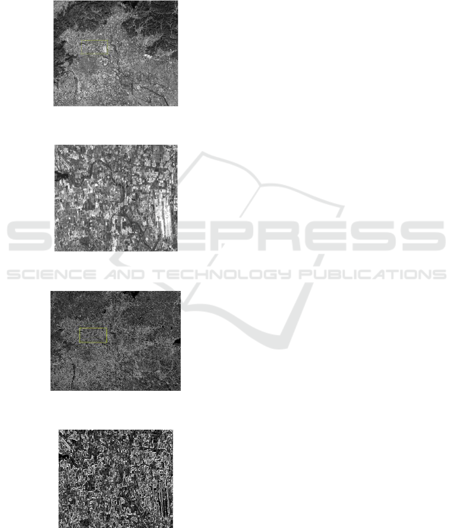
most of the image features (Figure1 and Figure2).
Figure 1: TM image after Gaussian smooth (4500×3500
pixels).
Figure 2: Beijing airport, shown in Yellow box for the
next view of the area, (950 × 500 pixels).
Figure 3: Gradient results of TM Satellite image
(4500×3500 pixels).
Figure 4: Beijing airport, shown in Yellow box for the
next view of the area,(950 × 500 pixels).
Calculating gradient and angle in each pixel. The
edges of the image indicate strong change of pixels.
The intensity of the edge of the pixel is used to find
the edge intensity, which is calculated using the
first-order partial derivative of the 3×3
neighborhood(Figure3 and Figure4).
Improved non-maximum suppression is used to
extract the edges of gradient images. The goal is to
change the “fuzzy edge” to “clear edge” in the
gradient value image, which is also called edge
refinement. The maximum values of the local
variation in the gradient image actually are found
and other values are deleted.
The entire edge with double threshold is
connected. The result of the non-maximum
suppression processing in the previous step includes
false edges, and it is also necessary to perform
threshold processing to reduce false edge points. If
the single-threshold processing is used and the
threshold is set low, there will be a false edge. If the
threshold is set high, the effective edge will be
deleted. The double threshold algorithm of CANNY
(Canny, 1986) is used. Two thresholds selection
method in edge detection is: First image histogram
statistics is performed. Then the maximum 80% of
the gray value is selected. The ratio of high and low
thresholds is 2:1. Points above the threshold are
connected to the edge. When the edge is reached.
points low the threshold are found in the 8
neighborhood points of the breakpoint. New edges
based on this point are collected until the entire
edges of image are closed.
2.2 Edge Contour Tracking Extraction
and Straight Line Extraction
Edge contour tracking extraction. Before the straight
line extraction is performed, it is necessary to extract
the continuous edge contours of image that edge
extraction has been completed. These contour lines
may be straight lines or curves, and they are required
to be extracted as long as they are continuous
(Figure5 and Figure6). This article has designed a
method for quickly extracting edge contours (Han,
2016).
Straight line extraction. After completing the
edge profile recognition, performing image Hough
transforming can significantly speed up image
processing. At the same time, the improved
HOUGH transformation can obtain the linear
endpoint coordinates, which can easily determine
the positional relationship between the straight lines.
IWEG 2018 - International Workshop on Environment and Geoscience
498
The HOUGH parameter is defined according to the
default value of the HOUGH function in the
opencv2.4.6 tutorial (Opencv2.4.6 tutorials.pdf.
http://docs.opencv.org/2.4/doc/tutorials/tutorials.htm
l.).
Figure 5: TM image(Inverting)NMS edge extraction result
(950×500 pixels).
Figure 6: TM image(Inverting) edge contour Tracking
extraction result (950 × 500 pixels).
2.3 SURF Detection Identifies Airport
Targets
SURF is a robust local feature detection algorithm.
It was first proposed by Herbert Bay et al. (2006) in
2006 and completed in 2008. Satellite image
extracted from the straight line segments is used for
SURF detection. SURF algorithm includes 4 steps:
Integral image processing, DOH approximation,
Scale space representation, SURF feature point
generation. Specific algorithm sees the literature of
Bay (Han, 2016).
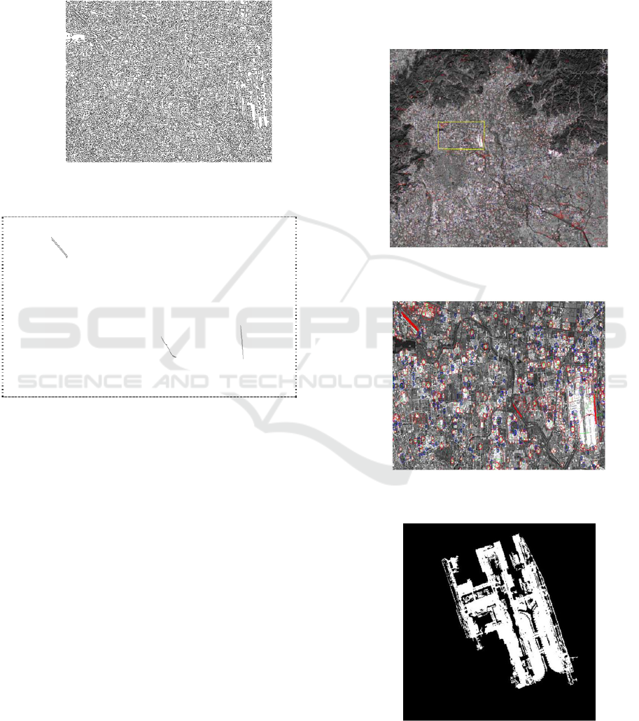
Two airports have been detected in the scene.
For this scene, a large number of detection points
were found in the airport area after SURF detection
was completed. The feature points on the airport
mostly fall at the intersections within the airport. In
the image, the entire map is searched according to
the position of the straight line segment coordinate
point. The area in the image where there are both
straight line segments and a large number of feature
points is defined as the airport area(Figure 7 and
Figure 8). There are two areas with two features in
the image. Therefore, there are two airports detected
in the image(Figure 9 and Figure 10). It can be seen
that the SURF feature can better reflect the
characteristics of the airport.
Figure 7: TM image Airport detection result (4500×3500
pixels).
Figure 8: TM image Airport detection result (950 × 500
pixels).
Figure 9: TM image Airport detection result-Beijing
Capital International Airport.
Detecting Airports in TM Satellite Images Based on Edge Tracing and SURF
499

Figure 10: TM image Airport detection result- small
Airport.
3 CONCLUSIONS
Experimental results show that TM images can be
used for edge extraction and target recognition, and
have achieved good results. The author (Bay et al.,
2006) used the same method to identify Chinese
Mapping satellite image. Mapping satellite image
resolution is 10 meters. Therefore, the recognition
effect of several images is better. Now author uses
only one scene TM image to identify. In the future,
more TM images can be used to do the same
recognition. At the same time, other types of
satellite images can also be used for identification
and extraction.
This paper proposes an improved edge extraction
method that can extract a variety of different types
of airport targets, with the advantages of fast
extraction and accurate extraction. If being coupled
with an appropriate interface, it can become a
standard airport automatic extraction procedure that
can directly and accurately detect the presence of
airport targets in remote sensing images. At the
same time, the method can be modified
appropriately, and other large-scale artificial targets
such as ports, bridges, etc., can also be detected.
The data set is provided by Geospatial Data
Cloud site, Computer Network Information Center,
Chinese Academy of Sciences.
(http://www.gscloud.cn).
ACKNOWLEDGMENTS
Fund Project: High-resolution aerial gamma
spectrometry and airborne imaging spectrometry
technology projects (2017YFC0602104), Deep
resources exploration and exploitation Key Projects,
National key research and development plan
REFERENCES
Bay H, Tuytelaars T, Van Gool L 2006 SURF: speeded up
robust features[C] Processing of the 9th European
Conference on Computer Vision Berlin Heidelberg:
Springer 404-417
Canny J 1986 A computational approach to edge
detection[J] IEEE Transactions on Pattern Analysis
and Machine Intelligence PAMI-8(6) 679-698
Chen X G 2005 Study on Airport Region Recognition in
Satellite Remote Sensing Image[D] Nanjing: Nanjing
University of Science and Technology
Deng X J, Peng H L 2002 An airport detection method
based on remote sensing imagery[J] Journal of Test
and Measurement Technology 16(2) 96-99
Gunst M ED 1991 Automatic extraction of roads from
SPOT images[R] Technical Report,Delft: Delft
University of Technology
Xiaoqing Han 2016 Detecting airports in high--resolution
Mapping Satellite using edge tracing--SURF method[J]
JOURNAL OF IMAGE AND GRAPHICS 21(10)
1337—1347
Hevenor R A, Chen P F 1994 Automated extraction of
airport runway patterns from radar imagery: US
5335298[P] 08-02
Michel A 1994 Airport detection using a simple
model,multisource images, and altimetric
informations[C]//Proceeding of the SPIE 2315, Image
and Signal Processing for Remote Sensing. Rome, Italy:
SPIE 2315: #604.
Opencv2.4.6 tutorials.pdf.
http://docs.opencv.org/2.4/doc/tutorials/tutorials.html.
Wang X, Wang B, Zhang L M 2012 Airport detection
based on salient areas in remote sensing images[J]
Journal of Computer-Aided Design & Computer
Graphics 24(3) 336-344
Yang S L, Lu L, Du Z G, et al. 2006 Automatic
recognition of airport runways in SAR images[J]
Journal of Wuhan University of Technology:
Transportation Science &Engineering 30(1) 56-59
Ying L, Song H N, Su Y. 2006 A fast algorithm to
detecting runway fromremote sensing images[J].
Computer Applications and Software 23(3) 94-97.
IWEG 2018 - International Workshop on Environment and Geoscience
500
