
Querying Distributed GIS with GeoPQLJ based on GeoJSON
Anna Formica, Mauro Mazzei, Elaheh Pourabbas and Maurizio Rafanelli
National Research Council, Istituto di Analisi dei Sistemi ed Informatica “Antonio Ruberti”,
Via dei Taurini, 19, I-00185, Rome, Italy
Keywords:
GIS, Pictorial Queries, Geographic Operators, GeoJSON Specifications, Distributed Databases.
Abstract:
Widespread use of the Web has increased the need to share and access distributed Geographic Information
Systems (GIS). In this context, spatial query languages act as a guideline for Web-based GIS. In this paper,
we focus on the Geographical Pictorial Query Language (GeoPQL) and enhance the related system in order
to query distributed GIS. This is achieved by using the GeoPQLJ functions which are based on the GeoJSON
format specifications. They are implemented in order to invoke the GeoPQL polygon-polyline operators,
which is the focus of this paper. We define the logical diagram of the GeoPQLJ distributed system, and
illustrate its underlying functionalities.
1 INTRODUCTION
In the area of Geographic Information Systems (GIS),
visual spatial query languages are still a challenging
topic. This arises from the need of providing the
user with interactive and user-friendly tools for data
manipulation and data retrieval, which are indepen-
dent of the physical organization of data. Nowadays,
an important requirement of these tools is also the
enhancement of the interoperability across different
systems in a world-wide distributed network, and the
presence of native data models for querying topolog-
ical relationships (Amirian et al., 2014). The usage
of standard query languages for spatial data handling
has been hindered by the lack of appropriate visual
query languages, and hence the need for advanced
geographic query languages in GIS has been empha-
sized since the nineties (Egenhofer, 1997).
Geographic queries, in general, can be better ex-
pressed by using graphical metaphors in query lan-
guages which are powerful to express the user’s men-
tal model of the query (Kuhn, 1993). In GIS, geo-
graphic query languages should satisfy two basic re-
quirements: they must be powerful and easy to use
at the same time. Powerful, because they have to re-
trieve information about complex database schemas,
keeping track of several relations existing among
data. Easy to use, because the access to the stored in-
formation should not be limited to experts, but should
be conceived for non-specialized end-users (Aoidh
et al., 2008) (Kapler and Wright, 2005). These two
basic requirements find a common solution in the de-
velopment of advanced visual geographic query lan-
guages (Calcinelli and Mainguenaud, 1994). Visual
query languages are high level declarative query lan-
guages, such as iconic (Lee and Chin, 1995), picto-
rial (Ferri and Rafanelli, 2005), or Query-by-Example
(Papadias and Sellis, 1995), etc. They are user-
friendly because their semantics is expressed by the
user drawing itself, which specifies the properties that
the query answer has to satisfy, and does not require
the user to be aware about the underlying query lan-
guage syntax.
In this paper, we concentrate on pictorial query
languages, i.e., visual languages where queries are
formulated by free-hand drawing (Formica et al.,
2018). In the literature, some proposals have already
discussed the way to formulate queries using picto-
rial configurations, for instance (Ferri and Rafanelli,
2005). In particular, in the mentioned paper a pic-
torial query language, called Geographical Pictorial
Query Language (GeoPQL), has been proposed in or-
der to address the user’s mental model of the query.
It allows users to formulate their queries using draw-
ing facilities and correctly interprets the query syntax
and semantics on the basis of its underlying algebra.
GeoPQL has been conceived as a stand-alone GIS
client which uses the ESRI Library (Arcview, 2018).
We focus on GeoPQL and we enhance the related
system in order to query distributed GIS by using
open source JTS libraries (JTS, 2018). In this per-
spective, we selected GeoJSON because it is a simple
Formica, A., Mazzei, M., Pourabbas, E. and Rafanelli, M.
Querying Distributed GIS with GeoPQLJ based on GeoJSON.
DOI: 10.5220/0007657201750182
In Proceedings of the 5th International Conference on Geographical Information Systems Theory, Applications and Management (GISTAM 2019), pages 175-182
ISBN: 978-989-758-371-1
Copyright
c
2019 by SCITEPRESS – Science and Technology Publications, Lda. All rights reserved
175

and text based format (GeoJSON, 2018). Since Geo-
JSON is a JSON encoding, the parsing and data inter-
changing for web services are flexible, and it is one
of the most popular encodings for transferring data to
client-side map visualization.
In the literature, beyond GeoJSON, the well-
known spatial formats are Shapefile, and Geogra-
phy Markup Language (GML) (Marqu
´
es-Mateu et al.,
2015). The Shapefile format is probably the most
common one in the fields of GIS and geomatics,
and was introduced by a commercial company (Esri,
2018). The GML format is a standard proposed by
the Open Geospatial Consortium (OGC) (OGC, 2018)
and essentially is an XML grammar for expressing ge-
ographical features whose specification is available in
several official documents. We selected GeoJSON be-
cause it is the most recent format, and is based on the
JavaScript object notation (JSON) (GeoJSON, 2018).
It is defined as a format for encoding a variety of ge-
ographic data structures, and is becoming a valid one
to send geographic data over computer networks or in
mobile devices (Sriparasa, 2013).
The main goal of this paper is to exploit the
data interchange property of GeoJSON to enhance
the GeoPQL system in order to pictorially query a
network of distributed GIS. To this end, we intro-
duce the GeoPQLJ functions that are based on the
GeoJSON format specifications, as illustrated in Sec-
tion 4. These functions are defined for the polygon-
polyline topological relationships
1
. In particular, the
operators we address in this paper are disjoint (DSJ),
inclusion (INC), touch (TCH), intersect (INT), and
pass-through (PTH). Successively, we enhance the
GeoPQL system to query and retrieve data in dis-
tributed GIS, and we describe the underlying logical
diagram. Then, we illustrate the functionalities of the
system by means of an experiment, where the results
of pictorial queries are given.
The paper is structured as follows. In the next sec-
tion, the related work is given, and in Section 3, an
overview about the GeoPQL operators is presented.
In Section 4, the GeoPQLJ functions are defined,
and in Section 5 the related distributed system is de-
scribed. In Section 6, the main functionalities of the
distributed system are illustrated. Finally, in Section
7 the conclusion is given.
2 RELATED WORK
Widespread use of the Web has increased the need to
share and access distributed GIS (Bo and Hui, 1999)
1
A polyline is non self-intersecting (self-crossing), with-
out loops, spirals, and bifurcations.
(Liang et al., 2015) (Vatsavai, 2002). The current
Web-based GIS mostly adopt traditional client/server
or browser/ server architectures (Liang et al., 2015).
In both these environments, the client/browser usu-
ally sends a request to the server, which processes it
and returns the result to the client. For this process,
spatial query languages essentially act as a guide-
line for Web-based GIS. As highlighted in (Amirian
et al., 2014), essentially two approaches are used for
handling spatial data. The first approach is to use
the specifications published and managed by OGC,
whereas the second one is to use web services as core
technologies, such as XML, XSD, WSDL, SOAP. The
main geospatial web service is Web Feature Service
(WFS), which provides access to geospatial data us-
ing GML format. This format contains both geomet-
rical and attribute properties of data.
For instance in (Vatsavai, 2002), the authors pro-
pose the spatial query language GML-QL derived
from XQuery, which is essentially based on two types
of queries, i.e., unary and binary types. They also de-
fine some spatial functions and operations to support
spatial queries. Similarly, in (Guan et al., 2006), the
authors propose GQL, a query language specification
to support spatial queries over GML documents by
extending the data model, algebra, and semantics of
XQuery.
In (Almendros-Jimenez et al., 2015), an XQuery
library for querying Open Street Map (OSM) has been
proposed, following the approach given in (Boucelma
and Colonna, 2004). This library is based on the
spatial operators originally introduced in (Clementini
et al., 1993) and (Egenhofer, 1991). In (Huang et al.,
2009), a similar proposal has been defined which is
based on GML, and also addresses the performance
problem of using XML/GML-native technologies in
order to manipulate large GML documents.
The aforementioned papers present an approach
similar to our proposal, but the former is limited to
the OSM environment, whereas the latter addresses
a general distributed environment without supporting
functional operators. With respect to these papers, our
approach can be used in a general distributed system
thanks to GeoJSON which, by making use of spatial
operators, allows the access to geo-spatial reposito-
ries in a more efficient way. In addition, with respect
to (Almendros-Jimenez et al., 2015), where data are
extracted according to a composition and filtering ap-
proach, in our proposal the user is not required to be
aware about complex query syntaxes because he/she
can benefit of the pictorial querying facilities. In fact,
we use GeoPQL (Ferri and Rafanelli, 2005), and en-
hance the related system in order to query distributed
GIS by using open source JTS libraries (JTS, 2018).
GISTAM 2019 - 5th International Conference on Geographical Information Systems Theory, Applications and Management
176

3 GeoPQL OPERATORS:
OVERVIEW
In this paper, we focus on GeoPQL which is based
on the notion of Symbolic Graphical Objects (SGO)
(Ferri et al., 2002), (Formica et al., 2013). It has
been defined to graphically represent the spatial
configurations of geographic entities (i.e., point,
polyline, and polygon), and the spatial relationships
between SGO.
Definition 3.1 [S GO]. Given a GIS, a Sym-
bolic Geographical Object (S GO) is a 5-tuple ψ =
hid,geometric type,ob jclass, Σ,Λi where:
• id is the S GO identifier assigned by the system to
uniquely identify the SGO in a query;
• geometric type can be a point, a polyline or a
polygon;
• ob jclass is the geographical concept name be-
longing to the database schema and iconized by
the S G O, identifying a geographical class (set of
instances) of the database;
• Σ represents the set of typed attributes of the SGO
which can be associated with a set of values by the
user;
• Λ is an ordered set of pairs of coordinates, which
defines the spatial extent and position of the SGO
with respect to the coordinate reference system of
the working area.
The GeoPQL algebra consists of a set of bi-
nary geo-operators, which are logical (Geo-union,
Geo-any, Geo-alias), metrical (Geo-difference, and
Geo-distance), and topological (Geo-disjunction,
Geo-touching, Geo-inclusion
2
, Geo-intersect, Geo-
crossing, Geo-pass-through, Geo-overlapping, Geo-
equality). Our focus, as mentioned in the Introduc-
tion, is on the polygon-polyline topological relation-
ships, therefore, in this work we consider a subset
of the topological operators, namely, Geo-disjunction
(DSJ), Geo-touching (TCH), Geo-inclusion (INC),
Geo-intersect (INT), and Geo-pass-through (PTH).
Indeed, the remaining operators are not considered
because in the case of the polygon-polyline rela-
tionship they are not applicable (for instance Geo-
crossing operator which is defined between polylines,
Geo-overlapping which is defined between polygons,
or Geo-equality which is defined between polylines
or between polygons).
2
Note that in our approach the operators cover and
covered-by, extensively used in the literature, can be rep-
resented by using the Geo-inclusion operator.
Definition 3.2 [Geo-operators]. Given a polygon
P , and a polyline L, which are two S GO. Let i, b,
and e denote, respectively, the interior, boundary, and
exterior points of the SGO. Then, the binary geo-
operations DSJ, INC, TCH, INT, and PTH, are for-
mally defined as follows, where k, j ∈ {i,b,e}:
• DSJ (geo-disjunction):
P DSJ L iff P
k
∩ L
j
=
/
0 j, k 6= e
• INC (geo-inclusion):
P INC L iff P
k
∩ L
j
= L
j
, j, k 6= e
• TCH (geo-touching):
P TCH L iff ∃x ∈ L
b
∩ P
b
, I(x), that is a neigh-
borhood of x, and only one of the following holds:
I(x ) ∩ L
j
∩ P
e
=
/
0 or I(x) ∩ L
j
∩ P
i
=
/
0,
where j 6= e.
• INT (geo-intersect):
P INT L iff P
k
∩ L
i
6=
/
0, k = i, e.
• PTH (geo-pass-through):
P PTH L iff P
k
∩ L
i
6=
/
0, k = i, e and P
e
∩ L
b
6=
/
0.
Note that in the above definition, the order of the
operands is not relevant. The geo-operators are in-
voked in the GeoPQLJ functions, which are intro-
duced in the next section.
4 GeoPQLJ FUNCTIONS
In this section, we introduce the GeoPQLJ functions,
that are based on the GeoJSON format specifica-
tion. GeoJSON is a format for encoding a variety
of geographic data structures using JavaScript Ob-
ject Notation (JSON) (Bray, 2014). A GeoJSON ob-
ject may represent a region of space (Geometry), a
spatial entity (Feature), or a list of Features (Fea-
tureCollection). It supports the following geometry
types: Point, LineString, Polygon, MultiPoint, Multi-
LineString, MultiPolygon, and GeometryCollection.
The geometry types of GeoJSON are de-
fined in the OpenGIS Simple Features Imple-
mentation Specification for SQL (SFSQL). They
are: 0-dimensional Point, and MultiPoint; 1-
dimensional curve LineString, and MultiLineString;
2-dimensional surface Polygon, and MultiPolygon;
and the heterogeneous GeometryCollection. GeoJ-
SON representations of instances of these geometry
types are analogous to the well-known text (WKT)
and well-known binary (WKB) representations, origi-
nally defined by OGC (OGC, 2018). In particular, the
former is a text markup language for representing ge-
ometry objects according to a vector format and ref-
erence systems of spatial objects. The latter is used
Querying Distributed GIS with GeoPQLJ based on GeoJSON
177

to transfer and store the same information in specific
geographic databases.
The GeoPQLJ functions have been inspired by
taking into account the syntax of Turf.js (Turf, 2018).
In the following, the spatial types Point, LineString,
and Polygon, which allow us to define the spatial
operators’ functions, are given. These operators are:
disjoint, inclusion, touch, intersect, and passthrough,
which are admissible for representing the topological
relationships between Polygon and LineString.
Types:
const point = {
”type”: ”Feature”,
”properties”: ,
”geometry”: {
”type”: ”Point”,
”coordinates”: [[x, y]]
}
}
const line = {
”type”: ”Feature”,
”properties”: ,
”geometry”: {
”type”: ”LineString”,
”coordinates”:[[x
1
, y
1
], [x
2
, y
2
], . . . ,[x
n
, y
n
]]
}
}
const polygon = {
”type”: ”Feature”,
”properties”: ,
”geometry”: {
”type”: ”LineString”,
”coordinates”: [[x
1
, y
1
], [x
2
, y
2
], . . . , [x
n
, y
n
], [x
1
, y
1
]]
}
}
In the following functions, SGO
1
and S GO
2
are generalizations of the geometric types
defined above.
1. declare function geopqlj
dsj:disjoint(SGO
1
, SGO
2
) {GeoPQLJ:booleanQuery
(SGO
1
, SGO
2
,”GeoPQLJ”)}
where the function disjoint is defined as follows:
function disjoint(geom1, geom2) {
switch (geom1.type) {
case ”LineString”:
switch (geom2.type) {
case ”Polygon”:
return !isLineInPoly(geom1, geom2);
}
break;
case ”Polygon”:
switch (geom2.type) {
case ”LineString”:
return !isLineInPoly(geom1, geom2);
}
}
}
2. declare function geopqlj inc:inclusion(SGO
1
, SGO
2
) {GeoPQLJ:booleanQuery
(SGO
1
, SGO
2
,”GeoPQLJ”) }
where the function inclusion is defined as follows:
function inclusion(geom1, geom2) {
switch (geom1.type) {
case ”LineString”:
switch (geom2.type) {
case ”Polygon”:
return isLineInPoly(geom1, geom2);
}
break;
case ”Polygon”:
switch (geom2.type) {
case ”LineString”:
return isLineInPoly(geom2, geom1);
}
}
}
3. declare function geopqlj tch:touch(SGO
1
, SGO
2
) {GeoPQLJ:booleanQuery(SGO
1
,
SGO
2
,”GeoPQLJ”) }
where the function touch is defined as follows:
function touch(geom1, geom2) {
switch (geom1.type) {
case ”LineString”:
switch (geom2.type) {
case ”Polygon”:
return isPointOnLineEnd(geom1, geom2);
}
break;
case ”Polygon”:
switch (geom2.type) {
case ”LineString”:
return isPointOnLineEnd(geom2, geom1);
}
}
}
4. declare function geopqlj int:intersect(SGO
1
, SGO
2
) {GeoPQLJ:booleanQuery
(SGO
1
, SGO
2
,”GeoPQLJ”)
where the function intersect is defined as follows:
function intersect(geom1, geom2) {
switch (geom1.type) {
case ”LineString”:
switch (geom2.type) {
case ”Polygon”:
return !booleanDisjoint(geom1, geom2);
}
break;
case ”Polygon”:
switch (geom2.type) {
case ”LineString”:
return !booleanDisjoint(geom2, geom1);
}
}
}
5. declare function geopqlj pth:passthrough(SGO
1
, SGO
2
) {GeoPQLJ:booleanQuery
(SGO
1
, SGO
2
,”GeoPQLJ”)
where the function passthrough is defined as follows:
function passthrough(geom1, geom2) {
switch (geom1.type) {
case ”LineString”:
switch (geom2.type) {
case ”Polygon”’:
return doLineStringAndPoly-
gonCross(geom1, geom2);
}
break;
case ”Polygon”:
switch (geom2.type) {
case ”LineString”:
return doLineStringAndPoly-
gonCross(geom2, geom1);
}
}
}
Table 1 summarizes the above mentioned functions
with the corresponding brief definitions and invoked
GeoPQL operators, where “Ret. T” stands for “Re-
turns True”.
5 THE GeoPQLJ DISTRIBUTED
SYSTEM
In Figure 1, the GeoPQLJ distributed system is il-
lustrated, where the dashed box represents the server
side of the system. As shown in the figure, within
the local GeoPQL system the user expresses his/her
pictorial query, which is transformed into an SQL
GISTAM 2019 - 5th International Conference on Geographical Information Systems Theory, Applications and Management
178
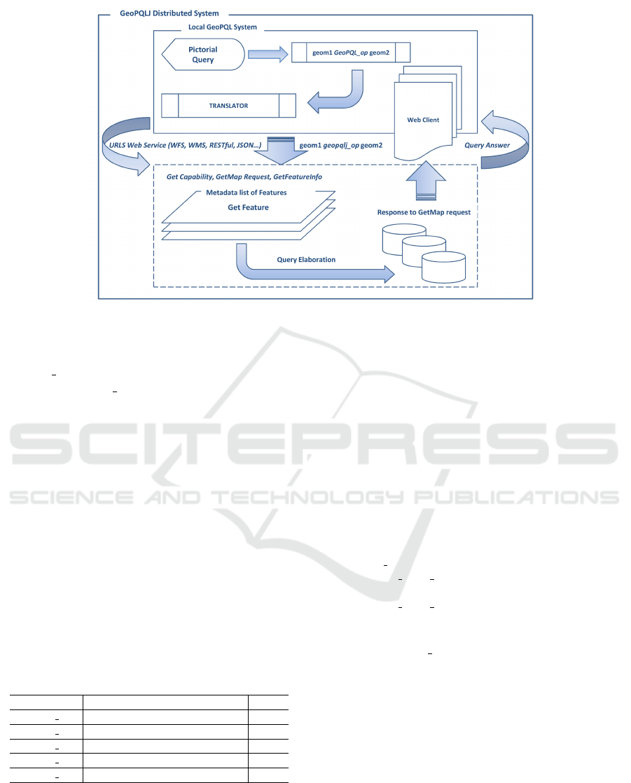
Figure 1: The GeoPQLJ distributed System.
like query, by identifying the corresponding operator,
GeoPQL op, as follows:
geom1 GeoPQL op geom2
where geom1 and geom2 are two SGO.
Successively, the SQL like query is translated into
the format defined according to the GeoPQLJ library
described in the previous section and a GeoPQLJ
query is generated. This query is sent to a Web Ser-
vice, in our case the Web Feature Service (WFS)
of the Open Geospatial Consortium (OGC, 2018),
which connects to the data sources in order to select
the required URLs. In other words, the WFS pro-
vides a data format, e.g., Geography Markup Lan-
guage (GML), GeoJSON, etc., that allows us to ac-
cess the territorial data directly from distributed data
sources, as well as to analyze and process them. In
this phase, the required URLs are retrieved by access-
ing the GeoPortal the user is interested in, where the
list of all possible available open services are shown.
Table 1: GeoPQLJ functions.
Name De f . Op.
geopql j ds j Ret. T when L is disjoint from P DSJ
geopql j inc Ret. T when L is in P INC
geopql j tch Ret. T when L touches P TCH
geopql j int Ret. T when L intersects P INT
geopql j pth Ret. T when L passes through P PTH
Analogously to the other web services, the
WFS uses the well-known methods GetCapability,
GetMap, and GetFeatureInfo. These methods capture
the general information about the metadata that con-
tains the list of features corresponding to the query.
This list is associated with the Geodetic Parameter
Registry (EPSG), that allows the accurate overlapping
of the required features.
In order to access the metadata related to the re-
trieved features, the GetFeature is applied to each fea-
ture. In particular, the system associates, on the basis
of the GeoJSON specification, the corresponding spa-
tial geometries (geom1, geom2) with the retrieved fea-
tures. The GetFeature allows us to access the content
of data (GeoData) of the features’ attributes, and the
related spatial coordinates, which are distributed on
different sites. In particular the following method is
invoked:
GeoJSON op(
geom1 f rom wkt(
0
Polygon([[x
1
, y
1
], [x
2
, y
2
], . . . ,
[x
n
, y
n
], [x
1
, y
1
]])
0
),
geom2 f rom wkt(
0
LineString([[x
1
, y
1
], [x
2
, y
2
], . . . ,
[x
n
, y
n
]])
0
)
) → true
where GeoJSON op corresponds to a generic GeoJ-
SON operator, and the wkt method converts the ge-
ometries to the Well-Known Text (WKT) geometry
formats (Turf, 2018). In the wkt method, the WK-
TReader extracts the geometry objects from either
Readers (i.e., the abstract class for reading character
streams) or Strings. It is a parser that allows us to read
the geometry objects from text blocks embedded in
other data formats (e.g., XML). Finally, the GetMap
request is sent to the Web Client, and the final query
answer is shown as a map.
Querying Distributed GIS with GeoPQLJ based on GeoJSON
179
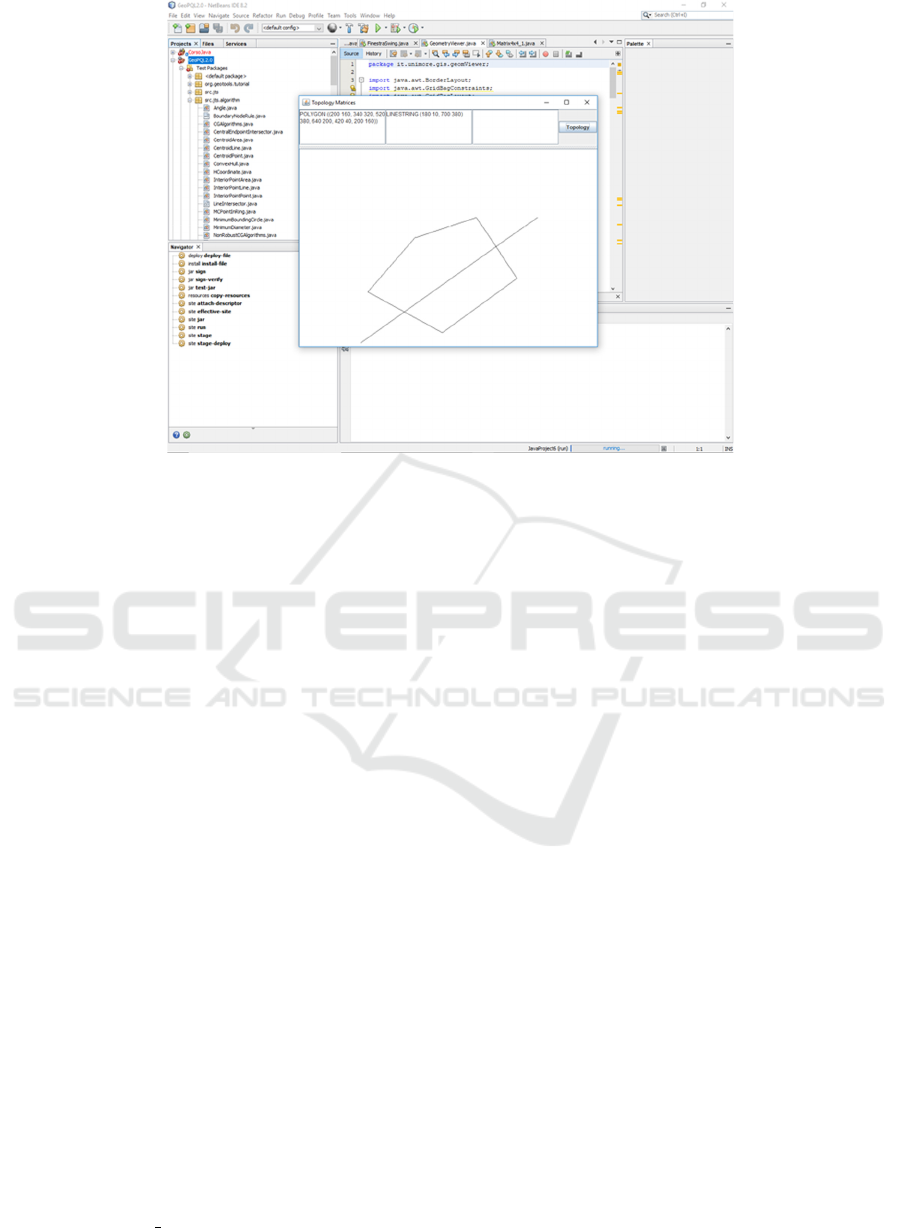
Figure 2: The pictorial query drawn by the user in GeoPQL.
6 ILLUSTRATION OF THE
SYSTEM
In order to better show the proposed GeoPQLJ
system, in this section an experiment is given. It has
been realized by accessing the data sources from the
site (Catalog, 2018), which publishes and manages
datasets, as for instance the U.S. Geological Survey
or NASA. In particular, let us suppose the user is
interested in the following query:
”Find the roads which pass through national parks
in New Mexico”
He/she formulates it by drawing a pictorial query
in the Local GeoPQL System as shown in Figure 2.
In this case the pictorial query is essentially given by
a polygon passed through by a polyline which will be
associated, respectively, with the national parks and
the roads of New Mexico as shown below. This query
is transformed into the following SQL like query:
geom1 PT H geom2
where geom1 and geom2 are a polyline and a poly-
gon, respectively, (or viceversa) and PT H is the
pass through geo-operator. In turn, this query is
transformed into the following query:
geom1 geopql j pth geom2
In this phase, the system associates, on the
basis of GeoJSON specification, the corresponding
spatial geometries (geom1, geom2) with the retrieved
features (i.e., GPS Roads and National Park Bound-
aries). In particular, the WFS service connects to the
data sources by means of the links given below. The
first link:
https://catalog.data.gov/dataset/gps-roads
refers to all interstate highways, US highways, most
of the state highways, and some county roads in New
Mexico. These data are represented according to a
1:100,000 scale. Furthermore, the other link:
https://catalog.data.gov/dataset/national-park-
boundariesf0a4c
refers to the National Park Boundaries in New Mex-
ico. In Figure 3 the geodata we are interested in, both
roads and national parks in New Mexico, are shown.
This query is then translated into GeoPQLJ syn-
tax and it is elaborated in the distributed system by
accessing the above mentioned links (see as Figure
1). To this end, the features GPS Roads and National
Park Boundaries are retrieved by applying the GetCa-
pability, GetMap, and GetFeatureInfo methods.
The answer to the query is delivered to the web
client and visualized as a map to the user. In partic-
ular, the roads which pass through the national parks
in New Mexico are 32. A fragment of the answer pro-
GISTAM 2019 - 5th International Conference on Geographical Information Systems Theory, Applications and Management
180
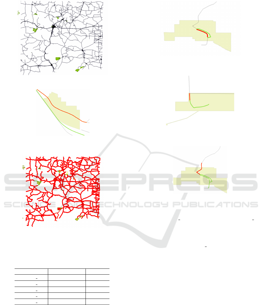
Figure 3: Roads and National Parks in New Mexico.
Figure 4: A fragment of the answer to the query with the
PTH operator.
Figure 5: A fragment of the answer to the query with the
DSJ operator.
vided by the system is shown in Figure 4.
Table 2: Selected objects and time(s).
Name Selected roads Time(s)
geopql j ds j 11256 4
geopql j inc 9 4
geopql j tch 0 5
geopql j pth 32 1
geopql j int 41 4
Analogously, the user might be interested to know
the roads that are disjoint from, are included in, touch,
or intersect the national parks. In the experiment, the
total number of features involved in the queries are
11299 roads and 510 parks. In Table 2, in the sec-
ond column the answers to these queries are shown,
whereas in the third column the execution times (in
seconds) are given. Note that, in the case of the
Figure 6: A fragment of the answer to the query with the
INC operator.
Figure 7: A fragment of the answer to the query with the
TCH operator.
Figure 8: A fragment of the answer to the query with the
INT operator.
disjoint (geopql j ds j) and the intersect (geopql j int)
operators, the numbers of selected objects are 11256
and 41, respectively, whose sum corresponds to the
total of 11299 roads. We observe that in the case of
the touch operator (geopql j tch), the result is equal
to zero due to the scale of the object representation.
Furthermore, the execution time related to it is higher
with respect to the others because of its more complex
semantics, as shown in Section 3 (see Definition 3.2).
In Figures 5, 6, 7, and 8, fragments of the answers
related to the DSJ, INC, TCH, and INT are shown,
respectively.
7 CONCLUSION
In this paper we presented the GeoPQLJ distributed
system for pictorially querying distributed GIS. We
introduced the GeoPQLJ functions which are based
on the GeoJSON format specifications. They have
been defined for the GeoPQL polygon-polyline op-
erators, which is the focus of this paper.
Querying Distributed GIS with GeoPQLJ based on GeoJSON
181

As a future work, we are planning to investigate
the problem of query constraint relaxation in dis-
tributed GIS, in order to provide approximate answers
to queries.
REFERENCES
Almendros-Jimenez, M., J., and Becerra-Teron, A. (2015).
Querying open street map with xquery. In 1st Int.
Conf. on Geographical Information Systems Theory,
Applications and Management (GISTAM).
Amirian, P., Basiri, A., and Winstanley, A. (2014). Evalu-
ation of data management systems for geospatial big
data. In ICCSA 2014, Part V, LNCS 8583, Springer-
Verlag, 678-690.
Aoidh, E. M., Bertolotto, M., and Wilson, D. C. (2008).
Understanding geospatial interests by visualizing
map interaction behavior. Information Visualization,
7(3):275–286.
Arcview (2018). www.esri.com/software/arcview (accessed
in November 2018).
Bo, H. and Hui, L. (1999). Design of a query language
for accessing spatial analysis in the web environment.
GeoInformatica, 3(2):165–183.
Boucelma, O. and Colonna, F. (2004). Gquery: a query
language for gml. In In Proc. of the 24th Urban Data
Management Symposium, 27-29.
Bray, T. (2014). The javascript object notation (json)
data interchange format. In RFC 7159, RFC Editor.
http://www.rfc-editor.org/rfc/rfc7159.txt.
Calcinelli, D. and Mainguenaud, M. (1994). Cigales, a vi-
sual query language for a geographical information
system: the user interface. Journal of Visual Lan-
guages and Computing, 5(2):113 – 132.
Catalog (2018). www.catalog.data.gov/organization (ac-
cessed in November 2018).
Clementini, E., Di Felice, P., and van Oosterom, P. (1993).
A small set of formal topological relationships suit-
able for end-user interaction. In LNCS 692, Springer-
Verlag, 277-295.
Egenhofer, M. (1991). Reasoning about binary topological
relations. In 2nd International Symposium on Large
Spatial Databases - SSD 1991, LNCS 525, Springer-
Verlag, 143-160.
Egenhofer, M. (1997). Query processing in spatial-query-
by-sketch. Journal of Visual Languages and Comput-
ing, 8(4):403 – 424.
Esri (2018). www.esri.com (accessed in November 2018).
Ferri, F., Pourabbas, E., and Rafanelli, M. (2002). The syn-
tactic and semantic correctness of pictorial configura-
tions to query geographic databases by pql. In ACM
SAC 2002, Spain.
Ferri, F. and Rafanelli, M. (2005). Geopql: a geographical
pictorial query language that resolves ambiguities in
query interpretation. In Journal of Data Semantics III,
LNCS 3534, Springer-Verlag, 50-80.
Formica, A., Mazzei, M., Pourabbas, E., and Rafanelli, M.
(2018). Approximate answering of queries involving
polyline-polyline topological relationships. Informa-
tion Visualization, 17(2):128 – 145.
Formica, A., Pourabbas, E., and Rafanelli, M. (2013). Con-
straint relaxation of the polygon-polyline topologi-
cal relation for geographic pictorial query languages.
Computer Science Information Systems, 10(3):1053 –
1075.
GeoJSON (2018). www.geojson.org (accessed in Novem-
ber 2018).
Guan, J., Zhu, F., Zhou, J., and Niu, L. (2006). Extending
xquery to query gml documents. Journal Geo-spatial
Information Science, 9(2):118 – 126.
Huang, C., Chuang, T., Deng, D., and Lee, H. (2009).
Building gml-native web-based geographic infor-
mation systems. Computers and Geosciences,
35(9):1802–1816.
JTS (2018). www.vividsolutions.com/jts/JTSHome.htm
(accessed in November 2018).
Kapler, T. and Wright, W. (2005). Geotime information
visualization. Information Visualization, 4:136–146.
Kuhn, W. (1993). Metaphors create theories for users. In
Frank, A. U. and I. Campari (Eds). Spatial Informa-
tion Theory: A Theoretical Basis for GIS, LNCS 716,
Springer-Verlag, 366-376.
Lee, Y. and Chin, F. (1995). An iconic query language for
topological relationship in gis. International Journal
on Geographical Information Systems, 9(1):26–46.
Liang, W., Zhanlong, C., Xincai, W., and Zhong, X.
(2015). Distributed geographic structure query
language-dgsql. Journal of Software Engineering,
9(2):328–336.
Marqu
´
es-Mateu, M., Balaguer-Puig, M., Moreno-Ram
´
on,
H., and Ib
´
anez-Asensio, S. (2015). A laboratory pro-
cedure for measuring and georeferencing soil colour.
In The Int. Archieves of the Photogrammetry, Remote
Sensing and Spatial Information Sciences, vol. XL-
7/W3, 2015, 36th Symposium on Remnore Sensing of
Environment.
OGC (2018). www.opengeospatial.org/standards (accessed
in November 2018).
Papadias, D. and Sellis, T. (1995). A pictorial query-by-
example language. Journal of Visual Languages and
Computing, 6(1):53–72.
Sriparasa, S. (2013). Javascript and json essentials. Packt
Publishing.
Turf (2018). www.turfjs.org (accessed in November 2018).
Vatsavai, R. (2002). Gml-ql: A spatial query language
specification for gml. www.cobblestoneconcepts.com
/ucgis2summer2002/vatsavai/ vatsavai.htm.
GISTAM 2019 - 5th International Conference on Geographical Information Systems Theory, Applications and Management
182
