
Multi-Agent Base Evacuation Support System Considering Altitude
Shohei Taga
1
, Tomofumi Matsuzawa
1
, Munehiro Takimoto
1
and Yasushi Kambayashi
2
1
Department of Information Sciences, Tokyo University of Science, 2641 Yamazaki, Noda 278-8510, Japan
2
Department of Computer and Information Engineering, Nippon Institute of Technology, 4-1 Gakuendai,
Miyashiro-machi, Minamisaitama-gun, Saitama 345-8510, Japan
Keywords: Mobile Ad Hoc Network, Mobile Agent, Multi Agent, Contingency Plan, Risk Management.
Abstract: In this paper, we propose an extension of an evacuation support system that we have previously proposed
(Taga, 2018). The system suggests evacuation routes in cases of disasters. We have confirmed the
usefulness of the system. When a disaster occurs, we anticipate that the current popular wireless
communication based on the Internet may not be very reliable. In order to accommodate such a problem,
our proposed system employs multiple mobile agents and static agents on smartphones that use a mobile ad
hoc network (MANET). The proposed system collects information by mobile agents as well as diffuses
information by mobile agents so that the system provides an optimal evacuation route for each user in a
dynamically changing disaster environment. In simulations, our system successfully guides evacuation users
to safe areas. The system, however, does not consider the altitude of the evacuation routes. Therefore, the
system may not be very useful in cases of flood. When a tsunami or a flood tide occurs, low altitude
location may be under water. Therefore, evacuees need to move along high altitude routes. In this paper, we
also take account of the altitude information for constructing evacuation routes.
1 INTRODUCTION
In this paper, we propose an evacuation support
system that provides evacuation routes in cases of
disasters, and verify the usefulness of the system. In
recent years, with the development of
communication and portable device technologies,
people can collect and spread information using the
Internet regardless of time and place. Current
popular wireless communication infrastructure is
supported by a series of base stations and one
communication equipment in such a base station
handles a lot of communication. Therefore, when
problems occur at equipment in such a
communication base station, it may be difficult, even
if possible, for the smartphones to use the Internet.
In fact, in the 2011 off the Pacific coast of Tohoku
Earthquake in Japan, we have observed a large-scale
communication failure due to corruption of the
communication equipment and traffic congestion.
Paralyzed communication infrastructure made it
difficult for people to collect information about the
conditions of transportation and safety information
about family and friends using smartphones.
Our proposed system addresses this problem of
communication infrastructure by constructing
mobile ad hoc network (MANET) by wireless
communication between users’ smartphones. Then
users can share information in such a network. Since
MANET is a network constructed with only portable
devices, it is possible to avoid problems due to
failure of communication infrastructure. However,
the ever changing topology of MANET makes stable
communication extremely difficult. Therefore, we
propose an information sharing method using mobile
software agents. A mobile agent is a program with
mobility, it has a feature of perceiving environment
and deciding its behaviour depending on the
environment. Our proposed system constructs
optimal evacuation routes by using such mobile
agents to share and collect information necessary for
evacuation.
In previous studies, we proposed basic
configuration of the evacuation support system and
verified its feasibility by simulators (Taga, 2016)
(Taga, 2017). In the previous study, we have
expanded the features of the system and verify its
usefulness with a simulator namely NS-3 (Taga,
2018). In the study, we have introduced new mobile
agents that actively collect information closely
Taga, S., Matsuzawa, T., Takimoto, M. and Kambayashi, Y.
Multi-Agent Base Evacuation Support System Considering Altitude.
DOI: 10.5220/0007693302990306
In Proceedings of the 11th International Conference on Agents and Artificial Intelligence (ICAART 2019), pages 299-306
ISBN: 978-989-758-350-6
Copyright
c
2019 by SCITEPRESS – Science and Technology Publications, Lda. All rights reserved
299

related to the users’ potential evacuation routes.
Even though the collected information includes
actual and potential dangerous area, it does not
collect information about altitude of the evacuation
routes. Thus our support system may guide the users
to low altitude area and let the users be drown in a
case of flooding.
In this paper, we consider altitude information
for constructing evacuation route. If a tsunami or
flood tide occurs, evacuating through low altitude
route could be dangerous. In order to evacuate
safely, evacuees should move along high altitude
route. Therefore, we propose an algorithm that
constructs high altitude evacuation route, and
construct simulator for verifying the feasibility of
the algorithm.
The structure of the balance of this paper is as
follows: the second section describes related works.
The third section describes the details the proposed
system. The fourth section describes the numerical
experiments and discusses the results, and the fifth
section discusses the future works and concludes the
discussion.
2 RELATED WORKS
Komatsu et al. proposed an evacuation system that
estimate impassable point automatically by
comparing evacuation route presented by the system
and actual evacuee's trajectories (Komatsu, 2018).
Estimated impassable points are shared between
evacuees by communication between their portable
devices, or server through available communication
infrastructure.
Wang et al. proposed a solution for fire
evacuation routing problems by applying artificial
bee colony optimization (BCO) algorithm (Wang,
2018). The BCO algorithm is a swarm intelligence
algorithm inspired by foraging of bees. They
simulated this solution at situations of evacuating
from buildings with multiple exits so that they
achieve to improve the total evacuation time.
Ikeda et al. proposed safety evacuation route
planning using multi-objective genetic algorithm
(MOGA) (Ikeda, 2016). The MOGA is a method
applying genetic algorithm to the multi-objective
optimization problem. An evacuee's handset records
GPS data and acceleration data, and send to crowd
server. The server calculates an evacuation route
considering evacuation distance, evacuation time
and the safety degree of evacuation route, and then
provide the optimal route to the evacuees.
Kartalidis et al. proposed evacuation routing
method that detects positions of evacuees by using
trilateration technique using wireless access points
and evacuees’ smartphones, and then constructs
evacuation routes based on cellular automata
(Kartalidis, 2018). The states of cellular automata
express the state of a specific position of the
evacuation area that indicates the presence of the
evacuees detected, obstacle and free area and more.
For each step of the exit path exploring process, the
state of each cell is refreshed. Therefore, evacuees
can evacuate avoiding impassable points.
Asakura et al. proposed algorithm to calculate a
simple evacuation route to reduce the burden of a
particular evacuee (Asakura, 2016). If an evacuation
route is complicated and meandering, the evacuees
may be confused. In order to mitigate this problem,
their proposed method calculates a route that has the
fewest number of turns at intersections.
Avilés et al. proposed an evacuation support
system using MANET and the ant colony
optimization (ACO) for indoor environments
(Avilés, 2014). In the study, they implemented ACO
by using mobile agents so that the ACO algorithm
can take the movement trajectory and speed of
evacuees in consideration. Then the evacuation
support system constructs an optimal evacuation
route for each user.
Ohta et al. studied on evacuation support
methods using ACO and MANET (Ohta, 2015). In
the study, they pointed out a problem such as a
conventional ACO may include dangerous locations
when it constructs evacuation routes. The problem is
caused by the dynamic nature of the disaster
environments such as conflagration or tsunami. In
order to mitigate this problem, they proposed an
improved ACO-based evacuation support system
that equips deodorant pheromone which erases ACO
pheromone traces when dangerous locations are
found. Goto et al. applied this proposed method to
real data of tsunami damage (Ohta, 2016). They
showed practical results by using the data of
Rikuzentakata city which suffered great damage due
to the 2011 off the Pacific coast of Tohoku
Earthquake. They verified their method is feasible
based on the real data.
Kambayashi et al. proposed and implemented a
system that collects safety information of evacuees
using mobile agents on MANET (Kambayashi,
2015). In the study, they proposed a method to
reduce the load on transmission by combining
multiple mobile agents into one. Nishiyama et al.
proposed communication system using portable
devices that switch between MANET and Delay
HAMT 2019 - Special Session on Human-centric Applications of Multi-agent Technologies
300

Tolerant Networking (DTN) according to
communication situations (Nishiyama, 2014). DTN
is a method for coping with a network environment
where maintaining stable communication connection
is hard to achieve. When communication is
disconnected, portable devices accumulate data, and
then transmitted when communication is resumed.
Their proposed system apply MANET when there
are many portable devices in the surroundings, and
apply DTN when there are few. With such a method,
they achieved to cope with various network
environments.
As mentioned above, there are various works
aimed at supporting disaster evacuation. In order to
carry out safe and quick evacuation, it is necessary
to promptly identify places that are impassable (such
as the place where a fire occurs) and construct
evacuation route. These can be achieved by using
servers or sensors device installed in town.
However, these fixed devices may be damaged when
a disaster occurs and become unusable. Instead, our
proposed system uses only smartphones owned by
evacuees, and identifies places that are impassable
and construct evacuation routes.
3 AGENT BASE EVACUATION
SUPPORT SYSTEM
In this section, we describe our proposed system in
detail. The proposed system aims to provide an
optimal evacuation route for each user (hereafter we
call the evacuation user). Since the proposed system
maintains the map information of the evacuation
area, it is possible to calculate the shortest route to
the destination (i.e. safe place). However, at the time
of a disaster, there should be many occurrences of
unsuitable points for evacuation (hereafter we call
dangerous point) due to fire, building collapse, or
inundation. Since nobody knows these points before
the occurrence of a disaster, it is necessary to collect
the information during evacuation. When an
evacuation user finds a dangerous point, he or she
inputs the position information to the system. Then
the proposed system constructs a new evacuation
route avoiding this dangerous point, and provides it
to the user. At the same time, the system diffuses the
information about the dangerous point and new route
to other users’ smartphones. As a result, evacuation
users other than the discoverer can know the
dangerous point and avoid it in advance. In order to
realize this function, we use multiple mobile agents.
A multi-agent system is a system that consists of
multiple agents and achieves tasks by their
cooperative operations. The agents can be
categorized into two types: mobile agents and static
agents. A mobile agent is generated when it is
needed and executes a task through migrating among
communication sites including smartphones. Every
mobile agent has a unique identifier. A static agent
resides on communication site including, of course,
a smartphone. Unlike mobile agents, static agent has
no unique identifier. We describe the details of each
agent we use in the proposed system below.
3.1 Static Agents
3.1.1 Information Agent
Information Agent is a static agent residing on a
smartphone that interacts with mobile agents and
constructs evacuation routes. When requested from
the system, it creates mobile agent.
The information agent processes the request in
the following order. (i) It generates the requested
mobile agent. (ii) It acquires the information
necessary for the generated mobile agent from the
node management agent and passes it to the mobile
agent. (iii) It stores the mobile agent in a queue. It
periodically checks the queue, and dispatches the
mobile agents to the neighbouring smartphones.
When a mobile agent comes from another
smartphone, the information agent receives
information held by the mobile agent. Then it passes
the requested information to the arrived mobile
agent and store it in the queue in the same way as
the above step (iii). The information agent records
the unique identifier of the mobile agent that visited
the smartphone as well as it created in a list called
visitor list. The information agent requests the
visitor list of other smartphones when it
communicates with them. It then passes the received
visitor list to the mobile agent that needs it in the
queue. The mobile agent decides the next destination
from this visitor list.
The information agent constructs evacuation
routes based on the information it initially has, and
the information collected from the visited mobile
agents. The evacuation route is the route to the
destination avoiding dangerous points that are
currently known by the information agent. The
evacuation route is determined based on the
Dijkstra’s algorithm. The Dijkstra’s algorithm is an
algorithm for solving the shortest path problem
between two nodes in a graph, and was proposed by
Edgar Dijkstra in 1959 (Dijkstra, 1959). In the
proposed system, the graph consists of intersection
as the nodes, and the distances between intersections
Multi-Agent Base Evacuation Support System Considering Altitude
301
as the edge weights. In this proposed system, in
order to construct high altitude evacuation route, this
proposed system calculate edge weight by dividing
distance by altitude of the node. Hence, high altitude
route is preferentially selected as evacuation route.
This evacuation route may not be the shortest route,
but evacuation users can avoid a tsunami or flood
tide and reach safe areas. The information agent
constructs an initial evacuation route at the system
start up time. After that, when a mobile agent arrives
and let the information agent know a dangerous
point exists on the current evacuation route, the
information agent reconstructs a new evacuation
route.
3.1.2 Node Management Agent
Node Management Agent is another static agent
residing on a smartphone for man-aging the
information on the smartphone. The node
management agent stores the dangerous point
information collected from the visited mobile agents
in the information table. At this time, if the same
information already exists in the information table,
the node management agent delete older information.
Also, if the information agent requests information
about dangerous points, the node management agent
passes the requested information.
3.2 Mobile Agents
3.2.1 Information Diffusion Agent
Information Diffusion Agent is a mobile agent that
diffuses the information of the dangerous point
found by the evacuation user to neighbouring
smartphones.
When an evacuation user finds a dangerous point
and input its information into the system, the
information agent generate the information diffusion
agent. The information agent passes the coordinates
of the discovered point to the generated information
diffusion agent. And then, the information diffusion
agent waits until a link with another smartphone is
established. After that the information diffusion
agent act as follows: (i) When communication links
with other smartphones are established, the
information diffusion agent copies itself by the
number of linked smartphones and moves to each
smartphone. However, if the information diffusion
agent finds that it has already visited the smartphone
(i.e. the smartphone’s visitor list has its identifier), it
does not move but commit suicide. (ii) After the
movement, it passes its own information to the
information agent on the destination, and be into
standby state until the next communication link
being established. It repeats this process a constant
number of hops. When the information diffusion
agent copies itself, it copies not only its own
information but also its own unique identifier.
Therefore, it does not move to the smartphone that
its own copy has visited. This mechanism prevents a
smartphone from receiving the same information
multiple times.
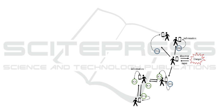
3.2.2 Information Collecting Agent
Information Collecting Agent is another mobile
agent that collects information about the events on
the evacuation route and returns to the original
smartphone. The information diffusion agent
diffuses the information discovered by the
evacuation user around the discovery point, but there
is no guarantee that this information can be
conveyed to all evacuation users who need it. In
order to solve this problem, we propose the
information collecting agent that actively collects
information diffused by the information diffusion
agent as shown in Figure. 1.
Figure 1: Information diffusing and information
collecting.
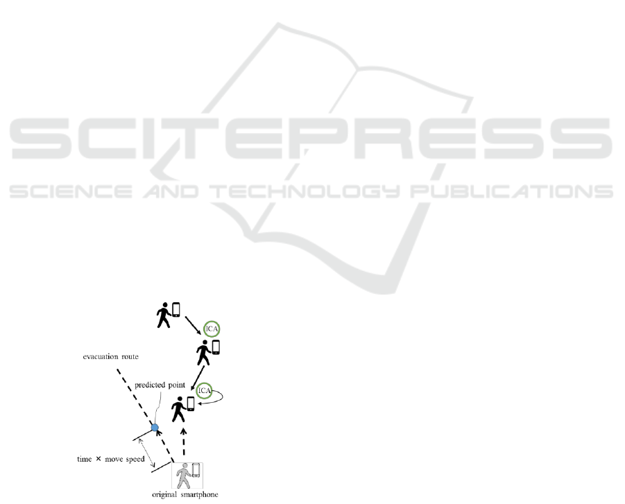
The information collecting agent returns to the
original smartphone after the information collecting
process, but there is a problem with the return
method. In the situation of the proposed system
being used, it is difficult to return through the
movement history of the agent in reverse order due
to the disappearance of the smartphones it has
visited. They may move out of wireless
communication range or their batteries may be
exhausted. For this reason, the proposed system
predicts the current location of the original
smartphone based on the evacuation route, moving
speed and elapsed time of the original smartphone.
HAMT 2019 - Special Session on Human-centric Applications of Multi-agent Technologies
302
The information agent generates the information
collecting agent at regular time intervals. Then, the
information agent passes the current evacuation
route information, the moving speed of the user, and
the life time of the information collecting agent, to
the generated information collecting agent. And
then, this information collecting agent waits until a
communication link with another smartphone is
established. When it is established, the information
collecting agent moves to the neighbouring
smartphone. The information collecting agent has
two states, the collecting state and the return state,
and the behaviour changes depending on the state.
Initially it is in the collecting state. The collecting
state is a state of collecting information and acts as
follows. (i) The information collecting agent moves
to the smartphones along the current evacuation
route of the user. Though, of course, it excludes the
smartphone that it has already visited. (ii) It acquires
information from the destination smartphone. The
information collecting agent repeats this process
during the collecting state. If the information
collecting agent acquires information that tells there
is a dangerous points on the evacuation route, or
exceeded half of the its own life time, or cannot find
the next migration candidate, the information
collecting agent becomes in the return state. The
return state is a state of returning to the original
smartphone and acts as follows. (i) The information
collecting agent calculates the predicted current
position of the original smartphone based on the
information it has; i.e. evacuation route information
of the original smartphone and the moving speed of
the evacuation user of the smartphone, and the
elapsed time since it was generated as shown in
Figure. 2. (ii) It moves to the smartphone closest to
the calculated expected position.
Figure 2: Predict the position of original smartphone.
Unlike the collecting state, in the return state, it may
moves to the smartphone it has visited before. It
repeats this process until returning to the original
smartphone. When the information collecting agent
return to the original smartphone, it passes the
collected information to the information agent on the
smartphone and disappears. If the information
collecting agent cannot returns even exceed the own
life time, or if it cannot find the original smartphone
in the vicinity of the calculated predicted current
position, it commits suicide.
One of the disadvantages of the information
collecting agent is that, since it is generated from
each smartphone, the network load tends to increase.
In order to mitigate this problem, the proposed
system controls the generation of the information
collecting agents by broadcasting messages to the
neighbouring smartphones that request to stop
generating the information collecting agent for
certain period. This message contains the address
and the evacuation route of the sender, and the life
time of the information collecting agent. The
smartphones that receive this message stop
generating information collecting agents if its own
evacuation route is the same as described one in the
message. If the own evacuation route is different
from what described in the message, it ignores and
discards the message. When the information
collecting agent returns to the sender smartphone of
the message, this smartphone broadcasts messages
that permit generating information collecting agents
and the collected information to the neighbouring
smartphones. The smartphones that have stopped
generating information collecting agent resume
generating of the agents when they receive this
message. The smartphones also resume generating
information collecting agents when the stopping
period in the message elapses.
4 NUMERICAL EXPERIMENT
This section describes the numerical experiment of
the proposed system. We have verified by
simulation in situations that people use the proposed
system at the disaster area. We used NS-3 for
simulation. NS-3 is a discrete-event network
simulator which is open for research and educational
use. The model of the communication environments
and processes in a form close to the real world, and
the simulator makes it possible to perform various
verification experiments.
Multi-Agent Base Evacuation Support System Considering Altitude
303
4.1 Experimental Conditions
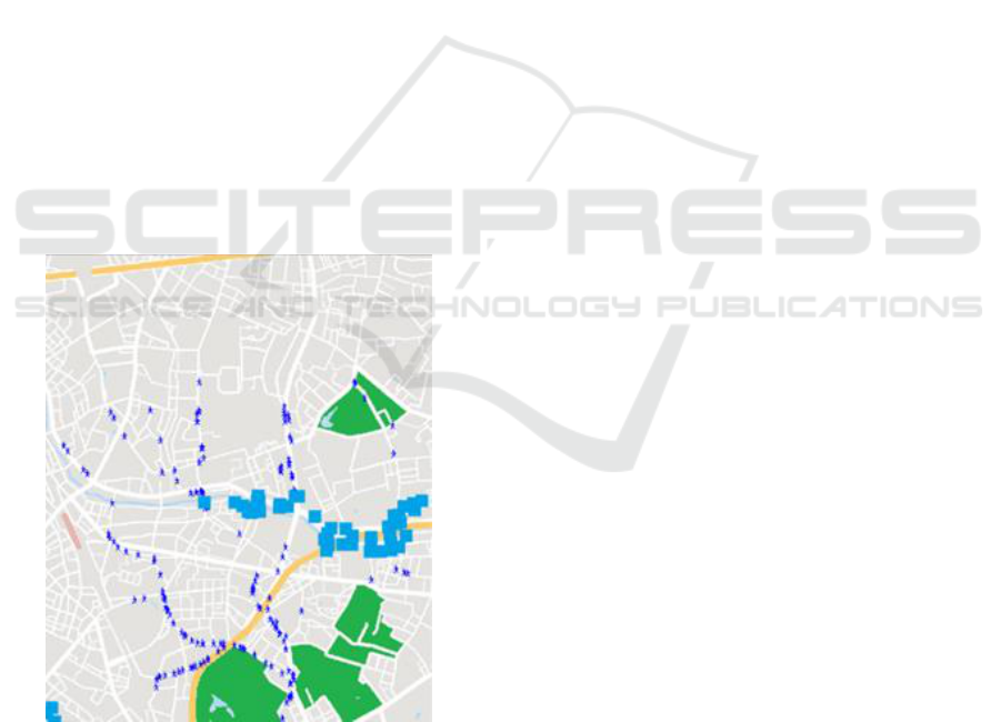
We have created a simulation map that represents
the evacuation area (Figure. 3). This simulation map
shows a part of downtown Tokyo, and is modelled
of the real geography. This area consists of upland,
lowlands and landfill sites, so it is rough terrain. In
this experiment, we need to verify the algorithm
considering altitude information, therefore such a
terrain is suitable as a model. We use the map
images acquired and edited from Google MAP
(Google, 2018). We also obtained the altitude
information from the map published by the
Geospatial Information Authority of Japan on the
Web (Geospatial Information Authority of Japan,
2018). This simulation map consists of nodes and
edges. The edge is a straight sidewalk, evacuees
move along the edge. The node is an intersection
point of edges. As destination of evacuees, five safe
areas provided in the map. This map is about 4.5
square kilometre in the real map, and includes
altitude information. The number of node is 1430,
the lowest altitude of node is 5.4 metre, and the
highest altitude of node is 32.0 metre. In order to
express tsunami or flood tide disasters, nodes
become the dangerous point in order from the lowest
altitude node, i.e. along the river. The dangerous
point increases every 10 seconds.
Figure 3: Simulation maps.
Evacuation users are randomly placed and move
toward nearest safe area from current position. The
moving speed of the evacuation user is set to 1
meters per second. The proposed system has the map
information. All evacuees moves through the
evacuation route constructed by the information
agent in his or her smartphone. The proposed system
does not have dangerous point information in
advance, and they will know for the first time when
evacuation user actually touches to the dangerous
point or be notified from other evacuation users
through mobile agents. When an evacuation user
knows a new dangerous point, the information agent
reconstructs the evacuation route avoiding this
dangerous point. At this time, the previous nearest
safe area from current position of evacuation user
may change. If such a case occurs, information agent
changes the destination to a new nearest safe area.
The communication distance of the smartphone is
50m. The evacuation user who arrives at the
destination (hereafter we call the safe evacuation
user), or who it is impossible that arrive the
destination due to be surrounded by dangerous
points (hereafter we call the dead evacuation user)
terminates the communication and stop. When all
evacuation users stop, the simulation ends.
In this verification experiment, we measured (1)
the number of the touches to the dangerous points of
all evacuees, (2) the number of the safe evacuation
users and the dead evacuation users. We have
verified the effect of considering the altitude
information. We measured the above numbers in the
case of not considering it, and in the case of not
using the proposed system (i.e. evacuation user's
smartphone calculates an evacuation route to shelter,
but does not share information of dangerous points,
and does not consider altitude information).
The number of hops of an information diffusion
agent is 1, and the life time and the generation
interval of an information collecting agent is set to
120 seconds. In all the cases, we further divided the
cases that the number of evacuees 50, 100, 150, 200.
We have carried out all the cases 50 times each, and
taken the averages as the results.
4.2 Results and Discussion
Figure. 4 shows the results of the number of the
touches to the dangerous points. "no altitude" is the
case of not considering altitude, and "altitude" is the
case of considering altitude. "not use" is the case of
not using the proposed system. In the case of the
number of the evacuees is 50 to 150, there is no
significant difference between the "not use" and the
"no altitude", but in the case of the number of
evacuees is 200, the "no altitude" is smaller than the
"no use". In all the cases, the "altitude" shows good
results.
HAMT 2019 - Special Session on Human-centric Applications of Multi-agent Technologies
304
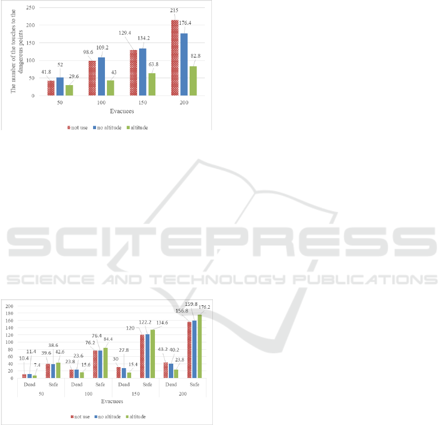
Figure. 5 shows the results of the number of the
safe evacuation users and the dead evacuation users.
Unlike the result shown in Figure. 4, in the case of
the number of the evacuees is 200, there is no
significant difference between result of "no altitude"
and "altitude". On the other hand, "altitude" shows
Figure 4: Results of the number of the touches to the
dangerous points.
good result in all the cases. If the number of
evacuation users who participate the MANET is
few, evacuees can only know information in the
nearby position because the network is only partially
constructed. Therefore, an evacuee nearby
dangerous point may be surrounded by other
dangerous points before escaping, even if he or she
could know the information of that point in advance.
Therefore, selecting higher evacuation routes by
avoiding places with low altitude in advance
contribute evacuees’ safe evacuations.
Figure 5: Results of the number of the safe evacuation
users and the dead evacuation users.
5 CONCLUSION
In this paper, we proposed an evacuation support
system that enables information sharing under
environments where people cannot use the Internet
communication due to the disaster. In the system, we
also took account of the altitude information when
constructing evacuation route. In the experiment, we
showed that evacuees can grasp dangerous points in
advance and avoid them by using the proposed
system. We also showed that evacuees can safely
evacuate by choosing high altitude routes as
evacuation routes when they are hit by tsunamis and
flood tides.
As a future work, it is necessary to address the
increase of the load in the relay smartphones. Since
the information collecting agent moves along the
evacuation route of the evacuation user, they
frequently move in a busy street such as main streets
and in front of evacuation centres. As a result, the
network load drastically increases in particular
places. Therefore, it is necessary to develop a
mechanism for controlling the flow amount of the
agent in such places. In addition, we need to
consider an evacuation time when choosing high
altitude route. By preferentially selecting high
altitude routes, evacuees can safely escape from the
tsunami and flood tides. However, since this route is
not the shortest route to the safe place, the
evacuation time will increase. As a method to solve
this problem, it is conceivable to change the priority
of selecting a route with a high altitude according to
the altitude of the current position of the evacuee. If
the current position of the evacuee is a place with a
low altitude, it is necessary to move quickly to a
high place. But if an evacuee is in a sufficiently high
place from the beginning, the necessity of selecting a
higher place is low. In this case, it may be safer to
move a route with shorter distance than to move a
route with a longer but higher altitude.
ACKNOWLEDGEMENTS
This work is partially supported by Japan Society for
Promotion of Science (JSPS), with the basic
research program (C) (No. 17K01304 and
17K01342), Grant-in-Aid for Scientific Research
(KAKENHI).
REFERENCES
Taga, S., Matsuzawa, T., Takimoto, M., Kambayashi, Y.,
2018. Multi-agent Base Evacuation Support System
Using MANET. In Tenth International Conference on
Computational Collective Intelligence, pp.445-454.
Taga, S., Matsuzawa, T., Takimoto, M., Kambayashi, Y.,
2016. Multi-Agent Approach for Return Route
Support System Simulation. In Eighth International
Multi-Agent Base Evacuation Support System Considering Altitude
305

Conference on Agents and Artificial Intelligence, vol.
1, pp.269-274.
Taga, S., Matsuzawa, T., Takimoto, M., Kambayashi, Y.,
2017. Multi-Agent Approach for Evacuation Support
System. In Ninth International Conference on Agents
and Artificial Intelligence, vol.1, pp. 220-227.
NS-3 Homepage. https://www.nsnam.org. (last accessed
13 December 2018).
Komatsu, N., Sasabe, M., Kawahara, J., Kasahara, S.,
2018. Automatic evacuation guiding scheme based on
implicit interactions between evacuees and their
mobile nodes. GeoInformatica, vol.22, issue 1,
pp.127-141.
Wang, C., Wood, L., C., Li, H., Aw, Z., Keshavarzsaleh,
A., 2018. Applied Artificial Bee Colony Optimization
Algorithm in Fire Evacuation Routing System.
Journal of Applied Mathematics, Volume 2018,
Article ID 7962952, 17 pages.
Ikeda, Y., Inoue, M., 2016. An Evacuation Route Planning
for Safety Route Guidance System after Natural
Disaster Using Multi-objective Genetic Algorithm.
Procedia Computer Science, vol. 96, pp.1323-1331.
Kartalidis, N., Georgoudas, I. G., Sirakoulis, G., Ch.,
2018. Cellular Automata Based Evacuation Process
Triggered by Indoors Wi-Fi and GPS Established
Detection. In 13th International Conference on
Cellular Automata for Research and Industry, pp.492-
502.
Asakura, K., Watanabe, T., 2016. An Algorithm for
Calculating Simple Evacuation Routes in Evacuation
Guidance Systems. Intelligent Interactive Multimedia
Systems and Services 2016, pp.287-295.
Avilés, A., Takimoto, M., Kambayashi, Y., 2014.
Distributed evacuation route planning using mobile
agents. Transaction on Computational Collective
Intelligence XVII, LNCS 8790, pp.128-144.
Ohta, A., Goto, H., Matsuzawa, T., Takimoto, M.,
Kambayashi, Y., Takeda, M., 2015. An improved
evacuation guidance system based on ant colony
optimization. In The 19th Asia Pacific Symposium on
Intelligent and Evolutionary Systems, vol. 5, pp.15-27.
Ohta, A., Goto, H., Matsuzawa, T., Takimoto, M.,
Kambayashi, Y., Takeda, M., 2016. A Guidance
System for Wide-area Complex Disaster Evacuation
based on Ant Colony Optimization. In Eighth
International Conference on Agents and Artificial
Intelligence, pp.262-268.
Kambayashi, Y., Nishiyama, T., Matsuzawa, T.,
Takimoto, M., 2015. An Implementation of an Ad Hoc
Mobile Multi-agent System for a Safety Information.
Information Systems Architecture and Technology:
Proceedings of 36th International Conference on
Information Systems Architecture and Technology –
ISAT 2015, Part II, pp.201-213.
Nishiyama, H., Ito, M., Kato, N., 2014. Relay-by-
Smartphone: Realizing Multi-Hop Device-to-Device
Communications. IEEE Communications Magazine,
vol. 52, no. 4, pp. 56-65.
Dijkstra, E., W., 1959. A note on two problems in
connexion with graphs. Numerische Mathematik, vol.
1, pp.269-271.
Google, ZENRIN, 2018. Google Maps.
https://www.google.co.jp/maps/.
Geospatial Information Authority of Japan, 2018. GSI
Maps. http://maps.gsi.go.jp/.
HAMT 2019 - Special Session on Human-centric Applications of Multi-agent Technologies
306
