
Knowledge Models and Image Processing Analysis in Remote
Sensing: Examples of Yakutsk (Russia) and Kaunas (Lithuania)
Sébastien Gadal
a
and Walid Ouerghemmi
b
Aix-Marseille Univ, CNRS, ESPACE UMR 7300, Univ Nice Sophia Antipolis, Avignon Univ,
13545 Aix-en-Provence, France
Keywords: Geographic Knowledge, Temporal Analysis, Geographic Ontologies, Spectral Databases, Spatial Modelling,
Simulation, Artificial Intelligence, Image Processing, Remote Sensing.
Abstract: The use of geographic knowledge in remote sensing constitutes one of the fundamental base of the
methodologies of image processing. Image processing, image analysis, and oriented-object recognition are
based on the geographic knowledge. More specifically, the large panel of supervised classifications methods
are one of the main example where geographic knowledge is necessary for both algorithms training and results
validation. Recently, with the coming back of the artificial intelligence (AI) wave, it appears that a large
spectrum of usually employed methodologies in remote sensing and image processing, are one of the main
drivers of AI: machine learning, deep learning are the most effective’s examples. As well as many based
processing algorithms like the Support Vector Machine (SVM) or the Random Forest (RF). However, despite
the constant performances of the methods of calculus; the geographic knowledge’s determines the accuracy
of recognition and classification in image processing and spatial modelling generated. In regard of the fast
seasonal and annual landscape changes in the Arctic climate, and complex urban structures, Yakutsk and
Kaunas cities contribute to the reflexion.
1 INTRODUCTION
The use of geographic knowledge in remote sensing
constitutes one of the fundamental base of the
methodologies of image processing. The efficiency of
the maps generated, oriented objects-recognition,
geographic object extractions and image analysis
depend on the expert knowledge acquired by the
analyst or/and the databases created: oriented-object
spectral databases, object databases, maps, etc (e.g.
Blaschke et al, 2008; Mennis and Guo, 2009). The
accuracy of the model of knowledge implemented in
image processing determines the capacity of
recognition, as well as the results obtained establishes
the quality of the spatial modelling of the landscape
changes for example. Image processing, spatial
modelling and geographic knowledge are
interdependent. The performances of algorithms
depends on the databases characterising the object to
identify (spectral, morphological, etc.), which are
implemented as learning bases and include expert
a
https://orcid.org/0000-0002-6472-9955
b
https://orcid.org/0000-0002-2119-7290
knowledge of the geographer (e.g. Huang and Jensen,
1997). These databases are used more and more for
image analysis and interpretation (e.g. Durand et al,
2017; Weber et al, 2018). Algorithms used in
artificial intelligence (AI) applied to remote sensing
applications and more specifically to the field of
geography process analysis, are mostly related to the
image processing methods (Random Forest (RF),
Support Vector Machine (SVM), neural network
(NN), etc.) (e.g. Vopham et al, 2018). Therefore,
there is a strong link between AI, image processing
and analysis, especially with the last advances in
terms of image acquisition and sensors development,
involving an increase in terms of data complexity.
The approaches of spatial and territorial
modelling and simulation base the processing on the
panel of algorithms like the SMA, Markov chains,
cellular automats, etc.). Algorithms used for the
calculus as well as the methods in image processing
remote sensing or in geographic modelling are not
new. The performances of the infrastructures and
282
Gadal, S. and Ouerghemmi, W.
Knowledge Models and Image Processing Analysis in Remote Sensing: Examples of Yakutsk (Russia) and Kaunas (Lithuania).
DOI: 10.5220/0007752202820288
In Proceedings of the 5th International Conference on Geographical Information Systems Theory, Applications and Management (GISTAM 2019), pages 282-288
ISBN: 978-989-758-371-1
Copyright
c
2019 by SCITEPRESS – Science and Technology Publications, Lda. All rights reserved
architectures of calculus, combined to the
implementations of massive data, and to the
important progress on the formalisation of the
knowledge in databases, are the last advances in AI
and big data fields (e.g. Chi et al, 2016).
One of the issue focus on the object ontologies.
Despise the lake of researches these since the 2000’s,
knowledge models and spatial ontologies are one way
to follow and reinvestigate (e.g. Breen, 2002). The
formalisation of the geographic and social
environments is generally structured on the expert
knowledge (field missions, perception, etc.), the
geographic databases (maps, census, etc.) organised
and structured in GIS and databases (e.g.
Ouerghemmi et al, 2017; Gadal and Ouerghemmi,
2016). Therefore, the processing approaches based on
object ontologies (e.g. spectral, morphological,
geometric characterisations), applies to the
heterogeneity and complexity of urban objects (i.e.
heterogeneous measurements). These objects are
related to: (a) the form aspects (e.g. metric,
geometric, morphology, textures, topology), (b) the
biophysical characteristics (e.g. spectral signatures,
spectral databases), and (c) the semantics (e.g.
geolinguistics modelling based on identification,
description of landscapes, human and societal uses,
territorial knowledge of inhabitants, perception and
conceptualisation of their home space/territory).
2 ISSUES IN URBAN REMOTE
SENSING
2.1 Multiplication of Earth
Observation Systems and
Geographic Databases
The fast grow of the Earth observation sensors
combines the flood of remote sensing, geographic,
environmental, or socioeconomic data. Flood and
massive data characterise the present of the remote
sensing: up to a few thousand spectral bands in
hyperspectral imagery, high temporal repetitiveness
of images taken (Meteosat 3
rd
generation, Sentinel 1
and 2, continuous covering on zone with UAV, etc.).
Storage and heterogeneous massive data processing
as well as the capacities of mutual enrichment by
multi-source processing revealed new
methodological challenges today. If the methods of
fusion, machine learning, and deep learning are today
established, the complexification of the knowledge
structure including a large panel of heterogeneous
data is still challenging.
The developed knowledge models are usually
structured in accordance to data and knowledge
integration in geographic information systems (GIS).
Image-processing methods will rely on artificial
intelligence for the extraction of information and
knowledge in accordance to available geographic
ontologies. The proposed approach is based on the
joint use of knowledge databases and artificial
intelligence for image processing and simulation
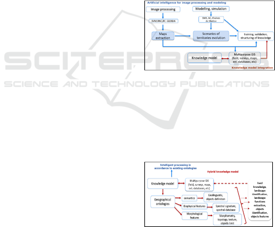
(Fig.1).
The increase of the massive data with the use of
hyperspectral data, high resolution centimetres
satellite, airborne images and high temporal
repetitiveness, requires automation of the processing
sequences. For that purpose, artificial intelligence
data processing methods (e.g. machine learning, deep
learning, etc.) are increasingly used in image
processing field.
Figure 1: The use of artificial intelligence based methods
for image processing and management of massive data.
The need of implementing different types of
knowledge to optimise the objects recognition
process (e.g. training, learning and validation of the
results) and to model the geographic and urban
changes constitutes the second methodological block
of the developed approach. For example, based-
knowledge morphological databases using specific
geometric rules were used to recognise and extract
urban objects (Fig. 2).
Figure 2: Implementation of knowledge model for image
processing and objects recognition.
Knowledge Models and Image Processing Analysis in Remote Sensing: Examples of Yakutsk (Russia) and Kaunas (Lithuania)
283
The different sequence of image processing and
modelling are related to the knowledge database for
training the models, creating rules, and validating and
interpreting the results.
2.2 Contribution of Knowledge
Databases in Remote Sensing
2.2.1 Knowledge Database Approaches
Result from the remote sensing image processing
depends of the geographic knowledge formalised in
databases or in ontological rules. Results of
classification (e.g. land cover maps), segmentation or
simulation will have no meaning without expert
knowledge that will serve to both enhancement of the
model training and improvement of the validation
results. The classification accuracy of trees species
identification made by airborne hyperspectral sensors
was enhanced by the expert knowledge training
compared to the learning made from spectral library
of in-situ measurements of the same species (i.e.
increase of Overall accuracy (O.A.) of up to 20%)
(Fig.3) (Ouerghemmi et al, 2018a), the obtained
O.A.(s) were < 25% for 11 vegetation species
identification using the Spectral Angle Mapper
(SAM) classifier. In (Ouerghemmi et al, 2018b), the
usefulness of an expert knowledge for vegetation
mapping was consolidated, and the mapping
performance was enhanced when using a machine
learning classifier jointly with the knowledge
database, O.A. was up to 46% for 8 vegetation species
identification.
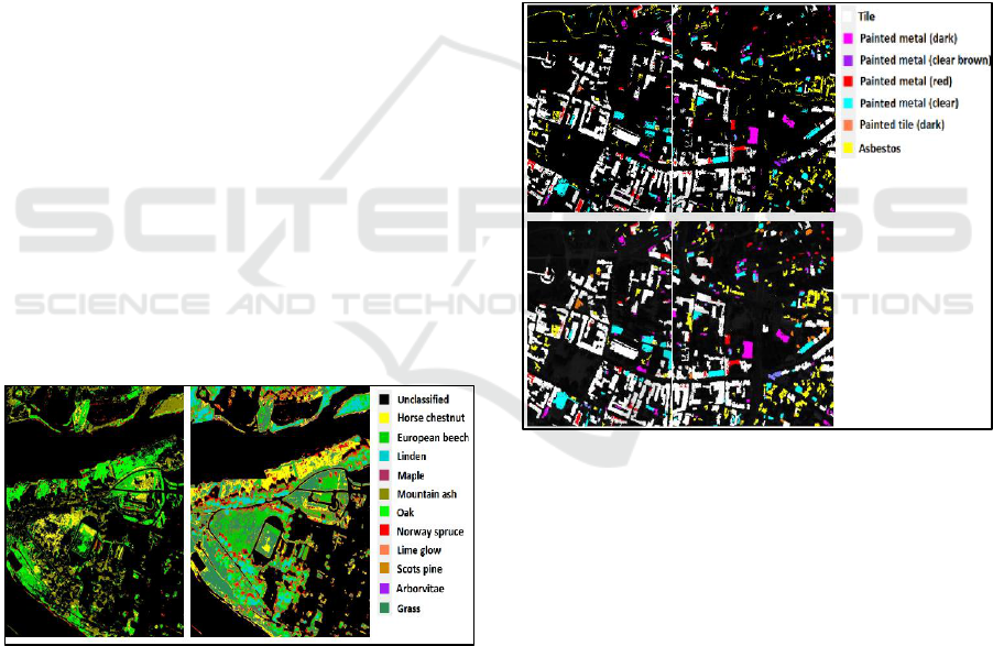
Figure 3: Vegetation species mapping over Kaunas city, at
left mapping by spectral library, at right mapping by
validation points of the expert knowledge.
In (Ouerghemmi et al, 2017; Gadal and
Ouerghemmi, 2016), the use of morphological
database for urban objects recognition in addition to
spectral oriented-object database, allows to solve the
misclassifications occurred when spectral database
are only using in the classification (Fig.4). The use of
morphometric databases provides the ability to detect
the socio-economic functions of buildings. The
implementation of other types of knowledge, for
example the ontologies, is helpful in image
processing for mapping and modelling the geographic
changes. Ontological knowledge can be introduced in
the form of rules, or can be used to build specific
simulation scenarios and thus to make the simulation
more reliable. Expert knowledge integration
including a large panel of thematic must be explored
for the future development in image processing
approaches. As well, today, the main issues concerns
essentially the standardisation of the data and
knowledge oriented object databases like the morpho-
spectral databases (e.g. Weber et al, 2018). The
standardisation is one of the key-issue to implement
and integrate the knowledge models in the methods
of image recognition and geographic processing.
Figure 4: (a) Urban objects identification by spectral
library, (b) morphological rectification for
misclassifications compensation.
The introduction of other types of knowledge (e.g.
ontological), could be very helpful in image
processing in terms of mapping and modelling,
indeed, ontological knowledge could be introduced in
the form of rules, or could be used to build specific
simulation scenarios and thus to make the simulation
more reliable. In that context, expert knowledge of
heterogeneous fields can be taken into consideration
for future development of image processing
methodologies. The issues will concern essentially
the management and the standardisation of these data
to make the integration in the processing frame easier
and simpler for the end-user (e.g. Weber et al, 2018).
(a)
(b)
GISTAM 2019 - 5th International Conference on Geographical Information Systems Theory, Applications and Management
284
2.2.2 Artificial Intelligence Processing:
Rules, Training, Databases Building,
and Ontological Recognition
Artificial intelligence is a rising branch of interest,
which is used more and more in remote sensing field.
The goal is to take advantage of the available
knowledge database in the processing step; the
progress of the operations will follow certain
ontologies. This will ensure the system autonomy
thanks to the injection of intelligence into the process.
Autonomous and intelligent systems permit to solve
the different problems of image mapping, objects
recognition, and simulation of different
environmental phenomenon’s. In parallel, the
knowledge database should follow certain structure
and certain standardization directive, so that the
different sources will be converted into ready to use
format for the different algorithms and models.
3 APPLICATIONS OF
KNOWLEDGE MODELS IN
POST-SOVIET URBAN
ENVIRONEMENTS (SOME
RESULTS)
3.1 Kaunas: Morpho-Spectral
Database Learning for the
Recognition of Built-Ups and
Urban Vegetation
In the following section, we present some application
related to the use of different types of knowledge
models in urban remote sensing. The socio-economic
building characterisation, building identification, and
urban vegetation detection in two post-soviet cities:
Kaunas in Lithuania (Baltic) and Yakutsk in the
Eastern Siberia characterised by the Arctic climate.
The city of Kaunas is characterised by a large
types of architectures and urban morphologies related
to the different historical periods since the 15 century.
Coexisting medieval, modern, Russian 19e century,
Art modern, soviet and postmodern architectures and
urban structures. The recognition and characterisation
of the built-ups combines two knowledge’s database:
the spectral database was used for urban classes’
identification, O.A. was up to 82% (Fig. 5), and
geometric rules related to the morphology of the
buildings for urban structures characterisation (Fig.
6). Application are made with an airborne VNIR
Rikola hyperspectral sensor with a GSD of 70 cm
with 16 spectral bands.
Bitumen
Tile
Paint steel in
red
Light paint
steel
Dark paint
steel
Paving
Turf
Coniferous
Deciduous
Figure 5: Recognition based on the spectral database of
urban materials (roof, human-made, vegetation).
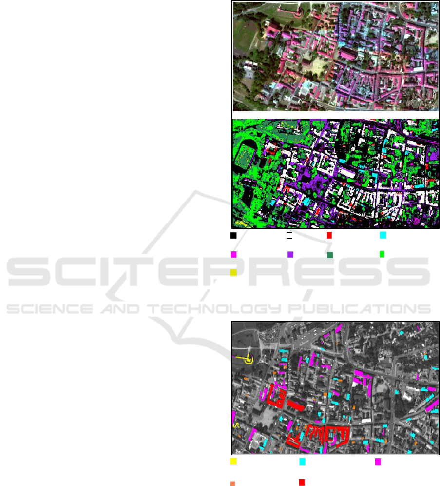
Medieval
(Kaunas Castle)
20e century (Art
Modern)
Gothic (end of the
15e century)
16e century
Modern period
(18e-19e century)
Figure 6: Recognition of medieval, reconnaissance and
modern buildings based on the geometric database.
The methodology applied integrates first, a
threshold based segmentation according to the roof
radiometry of the built-ups, and next geometric rules
are used for the extraction of specific buildings or
Knowledge Models and Image Processing Analysis in Remote Sensing: Examples of Yakutsk (Russia) and Kaunas (Lithuania)
285
urban structures. Several functions were identified in
this context, which are individual houses,
administrative building and cultural structures (Gadal
and Ouerghemmi, 2016) (Fig. 6). The proposed
methodology for urban objects extraction and
characterisation was inspired by the research carried
out in (Gadal and Ouerghemmi, 2015), from which,
an airborne image over Toulouse (France) was used
for the study. First, a spectral classification was
carried to extract the urban frame using a SAM
classifier, and second, textural attributes were used at
different bands to extract three socio-economic
classes, which are modern building, mean historical
buildings, and mean residential buildings.
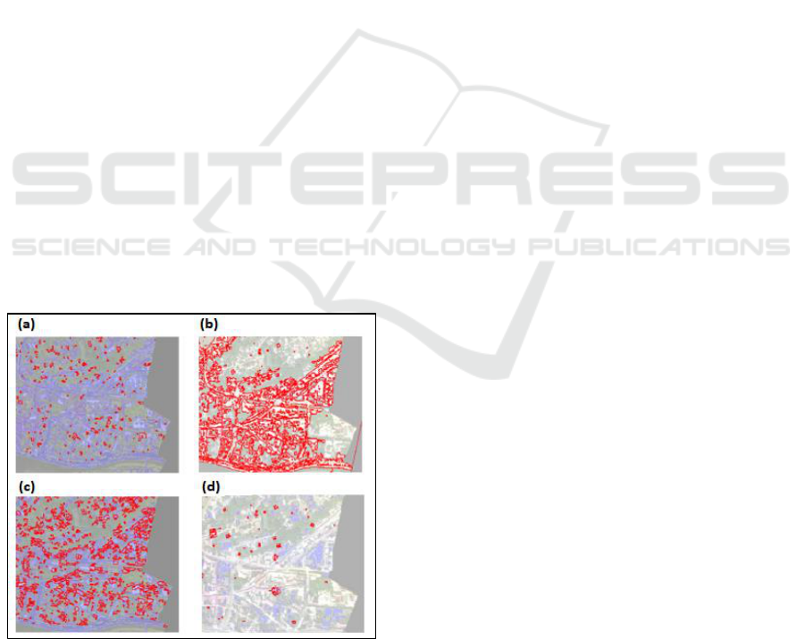
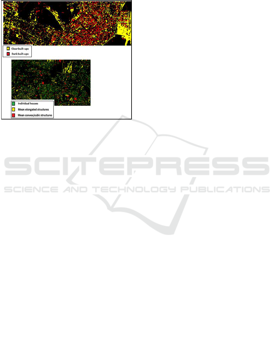
The figure 7 shows examples of the identification
of urban structures using 4 different rules based on
simple and complex geometric attributes, which are
respectively pixel count, [elongation + area],
[elongation + compactness] and [Minimum Bounding
Rectangle (MBR)-fill Ratio + Area] (i.e. respect. Fig
2.a, 2.b, 2.c and 2.d). First rule allows detecting urban
objects depending only on the attribute pixels count,
which could be useful for detecting easily and
roughly some specific structures in terms of size.
Second rule allows extracting the urban structures of
Kaunas city using both elongation and area attributes.
Third rule allows detecting compact and elongated
building corresponding to administrative and
residential building using attributes compactness and
elongation. Last rule permits the identification of
specific morphologies using Objects MBR attribute
and area attribute, most of the identified building
corresponds to religious structures.
Figure 7: Recognition of urban structures using geometric
rules (from the geometric urban oriented-object database).
3.2 Yakutsk: Multi-Temporal Urban
Landscape Changes and
Morpho-Spectral Database
Learning
This section presents some results of multi-temporal
satellite imagery use for environmental change
detection, urban frame identification, and
morphological processing, in this context, a Sentinel
2 multi-temporal images were used over Yakutsk for
inter-annual and inter-annual change detection
estimation of built-up areas within the city (Gadal and
Ouerghemmi, 2019). The used knowledge model
include multi-temporal Sentinel-2A satellite imagery
of several dates, high resolution SPOT 6 satellite
imagery, biophysical indices, validation points of
Google Street + field survey campaign, and
morphological measurements of the different urban
objects. Built-up areas were first extracted using the
merging of different biophysical indices (Fig. 8.a),
with O.A.(s) from 67% to 75%. In second step, built-
up areas change was identified for two dates using
Sentinel-2A imagery, the study revealed an increase
of about 12% in terms of built-ups between 2 years
interval. And finally morphological measurements of
the extracted objects permits to identify main socio-
economic classes of the city (Fig. 8.b), high resolution
SPOT 6 imagery showed encouraging results in terms
of morphological modeling of urban objects. This last
example well illustrates the usefulness of a hybrid
knowledge model for objects identification and
characterisation, nevertheless the artificial
intelligence part need to be further explored to better
automate the processing sequence and to enhance the
identification performance.
The perspectives behind the proposed
methodology is focused on two main axis which are
(a) the creation of a heterogeneous and standardized
knowledge model for application to remote sensing
issues, and (b) the development of a simulation
strategy for urban sprawl based on the use of
knowledge model. Indeed, the goal is to take
advantage of many available heterogeneous sources
of information in the simulation process. The
usefulness of such knowledge model could be found
at different levels of the simulation sequence, it
permits to build coherent simulation scenarios,
includes several biophysical indices (e.g. spectral
signatures, spectral indices) in the simulation model,
and bring some new features to the model like
ontologies and topologies related to the our specific
context and to our specific study zone. The
availability of such knowledge model can enhance the
model coherency and enhance the simulation
GISTAM 2019 - 5th International Conference on Geographical Information Systems Theory, Applications and Management
286
accuracy. Several studies have been already made in
the literature; nevertheless, the used knowledge
model was limited in terms of components.
Figure 8: Upper figure: urban frame identification over
Yakutsk city, lower figure: urban function extraction by
morphological attributes.
4 CONCLUSIONS
In this study, we presented an original
methodological scheme based on the joint use of a
hybrid knowledge model and artificial intelligence
for remote sensing application purpose. Several
application were already made using simple
knowledge model composed of biophysical or
morphological features or both at best. The idea
behind the methodology is to enrich the knowledge
model with several sources of information, which
could be very different at first sight, but will better
model the problem. The main issue will be related to
the standardisation of such sources of information, so
that the joint use of all the available sources could be
easily considered by the end-user.
The field of application related to such knowledge
model could be varied including objects mapping by
remote sensing imagery, objects characterisation and
identification, simulation of different environmental
phenomenon (e.g. urban sprawl, urban degrowth,
change detection, environmental phenomenon’s
management). Such knowledge model, will requires
the introduction of intelligence in both the structuring
procedure of the model and in the processing
sequence, including machine learning, deep learning
and neuronal networks methods. The joint use of
hybrid knowledge model coupled to the development
of intelligent rules and powerful training models will
contribute to the enhancement of image processing
and modelling methods and will constitute a new
exploration field.
ACKNOWLEDGEMENTS
French National Agency through Polar Urban Centers
(PUR, grant number ANR-15-CE22-0006) and
through Hyperspectral Imagery for Urban and
Environmental planning (HYEP, grant number ANR-
14-CE22-0016) supported this research.
SPOT 6 and Sentinel 2 data got the support of the
EQUIPEX GEOSUD (ANR-10-EQPX-20).
REFERENCES
Breen, C., Khan, L., and Ponnusamy. A., 2002. Image
Classification Using Neural Networks and Ontologies.
In Proc. 13th International Workshop on Database and
Expert Systems Applications, co-located with DEXA
2002, pages 98–102, Aix en-Provence, France.
Blaschke, T, Lang, S., and Hay, G.J., 2008. Object-Based
Image Analysis: Spatial Concepts for Knowledge-
Driven Remote Sensing Applications, New York, NY,
USA:Springer-Verlag.
Chi, M., Plaza, A., Benediktsson, J.A., Sun, Z. Shen, J. and
Zhu, Y., 2016. Big Data for Remote Sensing:
Challenges and Opportunities. Proceedings of the
IEEE, vol. 104, no. 11, pp. 2207-2219.
Durand, N. et al, 2007. Ontology-based object recognition
for remote sensing image interpretation, In 19th IEEE
international conference on tools with artificial
intelligence (ictai 2007), Patras, Greece, pp. 472-479.
Huang, X., and Jensen, J. R., 1997. A machine-learning
approach to automated knowledge-base building for
remote sensing image analysis with GIS data.
Photogrammetric Engineering and Remote Sensing, 63,
1185–1194.
Gadal, S., 2012. Geographic Space Ontology, Locus-
Object, and Spatial Data Representation Semantic
Theory. Universal Ontology of Geographic Space:
Semantic Enrichment for Spatial Data, IGI Global,
pp.28-52, 9786-1-4666-032-27-1.
Gadal, S., and Ouerghemmi, W., 2015. Morpho-Spectral
Recognition of Dense Urban Objects by Hyperspectral
Imagery. In ISPRS Geospatial week, 28 Sept – 02 Oct,
La Grande-Motte, France.
Gadal, S., and Ouerghemmi. W., 2016. Morpho-spectral
objects classification by hyperspectral airborne
imagery. In Proceedings of the 8th Workshop on
Hyperspectral Image and Signal Processing: Evolution
in Remote Sensing (WHISPERS), Los Angeles, CA.
Gadal, S., and Ouerghemmi. W., 2018. Multi-Level
Morphometric Characterisation of Built-ups in Siberian
Knowledge Models and Image Processing Analysis in Remote Sensing: Examples of Yakutsk (Russia) and Kaunas (Lithuania)
287

Sub-Arctic Urban Area: Yakutsk. In GEOBIA 2018:
From pixels to ecosystems and global sustainability,
Montpellier, France.
Gadal, S.; Ouerghemmi, W., 2019. Multi-Level
Morphometric Characterization of Built-up Areas and
Change Detection in Siberian Sub-Arctic Urban Area:
Yakutsk. ISPRS Int. J. Geo-Inf., 8, 129.
Mennis, J., and Guo, D., 2009. Spatial data mining and
geographic knowledge discovery—An introduction,
Computers, Environment and Urban Systems, Volume
33, Issue 6, 2009, Pages 403-408, ISSN 0198-9715.
Mozgeris, G. Juodkienė, V., Jonikavičius, D., Straigytė, L.,
Gadal, S. et al., 2018. Ultra-Light Aircraft Based
Hyperspectral and Colour-Infrared Imaging to Identify
Deciduous Tree Species in an Urban Environment.
Remote Sensing, MDPI, 2018, 10 (10).
Ouerghemmi, W., Gadal, S., Mozgeris, G., Jonikavičius,
D., and Weber, C., 2017. Urban objects classification
by spectral library: feasibility and applications. In 2017
Joint Urban Remote Sensing Event (JURSE), Dubai,
pp. 1- 4.
Ouerghemmi, W., Gadal, S., Mozgeris. G., 2018a. Urban
Vegetation Mapping using Hyperspectral Imagery and
Spectral Library. In IEEE International Geoscience and
Remote Sensing Symposium (IGARSS) 2018, Valencia,
Spain. pp.1632-1635.
Ouerghemmi, W., Gadal, S., Mozgeris, G., and
Jonikavičius, D., 2018b. Urban vegetation mapping by
airborne hyperspectral imagery: feasability and
limitations. In WHISPER 2018: 9th Workshop on
Hyperspectral Image and Signal Processing: Evolution
in Remote Sensing, Amsterdam, Netherlands. pp.245-
249.
VoPham, T., Hart, J. E., Laden, F., and Chiang, Y. Y.
(2018). Emerging trends in geospatial artificial
intelligence (geoAI): potential applications for
environmental epidemiology. Environmental health: a
global access science source, 17(1), 40.
Weber, C., Aguejdad, R., Briottet, X., Aval, J., Fabre, et al.,
2018. Hyperspectral Imagery for Environmental
Planning. In Proc. of the IEEE International
Geoscience and Remote Sensing Symposium (IGARSS),
Valencia (E).
Zakharov, M., Filippova, V., Savvinova, A., Pestereva, K.,
and Gadal, S., 2017. Recognition of Landscape
Structures by Toponymical Map and Remote Sensing
Analysis (Khangalassky district, Yakutia). In IX Arctic
Congress in Social Sciences (ICASS IX): "People and
Place", Jun 2017, Umea, Sweden.
GISTAM 2019 - 5th International Conference on Geographical Information Systems Theory, Applications and Management
288
