
GIS-based Livability Assessment: A Practical Tool, a Promising
Solution?
Anna Kovacs-Gyori
Department of Geoinformatics – Z_GIS, University of Salzburg, Schillerstr. 30, 5020 Salzburg, Austria
Keywords: Livability, Urban Form, Urban Function, Spatiotemporal Analysis, Social Media, Urban Planning,
Walkability.
Abstract: Livability is a complex phenomenon, describing urban quality in the light of dwellers’ needs and expectations
towards the urban environment. Accordingly, the conceptualization and assessment of livability have various
challenges, ranging from the subjectivity of the dwellers’ needs to the dynamics of urban life. The first part
of the paper briefly introduces these challenges and the key elements in the concept of urban livability. As a
follow-up, the rest of the paper provides potential approaches to grasp the complexity of urban quality and to
handle the challenges of livability assessment. GIS has a significant role in each of these approaches, thereby
the paper concludes with an evaluation of the advantages and relevance of GIS-based livability assessment.
Overall, the current summary supports the hypothesis that GIS-based livability assessment implies more than
a practical tool, by providing a general approach to understand and assess livability in a transferable way.
Thereby livability assessment is appropriate to support urban planners in the improvement of urban quality,
as well.
1 INTRODUCTION
Livability is a much-discussed concept in scientific
research for investigating city quality (Kamp et al.,
2003; Kashef, 2016; Ley and Newton, 2010; Pacione
2003; Ruth and Franklin, 2014; Veenhoven, 2000).
However, measuring livability is a challenging task
due to the complexity of urban environments and the
subjectivity of the human perception along with the
lack of a consensual definition of livability or its
factors.
The notion of livability has become quite popular
in the past few years, supposedly due to the so-called
“livability rankings” performed by various
companies and researchers (Giap et al., 2014; Kashef,
2016; Okulicz-Kozaryn, 2013). This rising interest
shows the relevance of the investigation of urban
quality, however, these lists are usually used rather
for city-marketing purposes than the actual
representative assessment of livability. The most
significant limitation of livability rankings is the lack
of intra-urban scale in their results and the
underrepresented importance of residents’ (often
subjective) needs. Overall, livability rankings tend to
represent the standard of living instead of actual
livability (Conger, 2015; IMCL, 2011; Kashef, 2016).
On the other hand, livability as a scientific
concept has much more to offer, not just by
representing differences between various socio-
economic groups and intra-urban scales but by
providing a transferable conceptual framework also
for planners aiming to improve urban quality (Brown,
2003; Conteh and Oktay, 2016; Kovács-Győri and
Reinel, 2017). This means that through livability
assessment, a city – or a given area within the city –
can be “diagnosed” before actual planning actions
take place, by providing an overview on the existing
challenges and insufficiencies of various urban
elements such as transportation or urban parks
(Kolcsár and Szilassi, 2018; Szell, 2018; Žlender and
Ward Thompson, 2017). However, because each city
and its urban system is unique, the assessment should
be robust and transferable to reflect the characteristics
of different places adequately (Albeverio et al., 2008;
Miller et al., 2013).
The improvement of urban quality – as a way to
respond to various urban issues with local or global
origin – is often a goal in international initiatives as
well such as the Sustainable Development Goals
(SDG) and the New Urban Agenda (NUA) (Caprotti
et al., 2017; Costanza et al., 2016; United Nations
General Assembly, 2015, 2016). However, it is often
Kovacs-Gyori, A.
GIS-based Livability Assessment: A Practical Tool, a Promising Solution?.
DOI: 10.5220/0007753702890296
In Proceedings of the 5th International Conference on Geographical Information Systems Theory, Applications and Management (GISTAM 2019), pages 289-296
ISBN: 978-989-758-371-1
Copyright
c
2019 by SCITEPRESS – Science and Technology Publications, Lda. All rights reserved
289

challenging to assess the current conditions regarding
the affected population and the localization of the
problems within the city. Especially, because cities as
complex systems are hard to be evaluated in details
(Batty, 2013). As a conceptual framework, livability
can also support these endeavors of SDG and NUA
by depicting the complex urban system and its
components through the lens of the “person-
environment” relationship (Kamp et al., 2003;
Pacione, 2003). Based on Van Kamp et al. (2003) the
quality of this relationship is considered as a basic
definition of livability.
While livability can provide a conceptual
framework for urban quality assessment, GIS makes
the practical analysis possible and valuable (Onnom
et al., 2018; Pacione, 2003; Yin et al., 2018). First, by
using GIS, data can be collected, stored and analyzed
according to thematic groups representing various
elements of the urban system (e.g., transportation,
public spaces, urban green). Second, the
consideration of spatial and temporal aspects is
crucial in urban analysis, which is, of course, another
advantage of using GIS for livability assessment.
Last, the visualization of the results in the form of
maps can support planners and decision makers in the
further steps of urban quality improvement.
To utilize the advantages of GIS in livability
assessment, the concept of livability – by highlighting
its key elements and potential assessment factors –
should be investigated in a systematic way (Section
2). As a follow-up, Section 3 summarizes different
approaches to assess and evaluate a selection of these
factors, as well as their robustness and application in
urban planning. Finally, Section 4 gives a synopsis of
the possible data sources along with the advantages
and limitations of GIS-based livability assessment.
2 THE CONCEPT OF
LIVABILITY
This section provides an overview of the
conceptualization of livability and its assessment
describing the definition of livability and its key
elements in the form of a conceptual framework. This
framework corresponds to the first step in the
complex task of assessing the livability of cities, by
also considering the subjective perception of their
dwellers.
2.1 Definition
There is no general consensus on the definition of
livability. However, the various existing definitions
often share some of the important characteristics,
such as the quality of the urban environment in the
light of the perception and expectation of the dwellers
(Kamp et al., 2003; Pacione, 2003; Ruth and Franklin,
2014).
Based on Pacione (2003), Van Kamp et al. (2003)
and Ruth and Franklin (2014) I interpret livability as
the quality of the person-environment relationship in
the urban context, concerning the needs and
expectations of the residents towards the urban
environment. The perception of the people
profoundly influences these needs and expectations,
and their personal values, thereby making the
livability assessment highly challenging (Brown,
1975; Pacione, 1990; Veenhoven, 2000).
Although this general definition serves as a good
starting point for any further step in assessing
livability, a framework on the potential factors and
their systematic assessment is still lacking.
2.2 Key Elements
As mentioned in Section 2.1, I consider livability as
the quality of the person-environment relationship,
based on what this “environment” provides and how
it fulfills the needs and expectation of the residents.
In the proposed livability assessment framework,
I identified the key elements of this person-
environment relationship, to represent urban life
(Figure 1).
The upper part of the figure describes the
individual aspects regarding the dwellers’ needs and
values. These values usually depend on many
individual factors, e.g., the length of residency, sense
of place, or the degree of integration into society
(Bonaiuto et al., 1999; Fried and Gleicher, 1961;
Merton, 1968; Taube and Levin, 1971). Furthermore,
the needs and expectations themselves can vary
according to the level of development in an area. The
lower part of the figure depicts the urban
environment, consisting of the built and natural
environment along with the infrastructure as urban
form, whereas urban functions represent what this
environment can provide for the citizens.
GISTAM 2019 - 5th International Conference on Geographical Information Systems Theory, Applications and Management
290
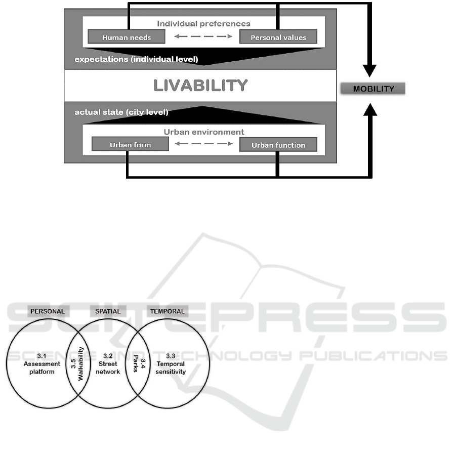
Figure 1: Key elements in livability.
2.3 Properties of Livability
Based on the person-environment relationship and the
key elements introduced in 2.2 (personal aspects,
urban form, urban functions) I identify three major
characteristics of these elements – and thereby the
properties of livability.
Figure 2: Use cases representing the properties of livability.
As Figure 2 illustrates, the use cases described in
Section 3 reflect given livability properties to grasp
the complexity of livability assessment. Thereby it is
possible to focus on the important characteristics of
livability in a systematic way. Similar to urban form
and urban functions, these properties are mostly only
separable on a conceptual level, whereas in the real
urban system, they are concurrent. Accordingly, all
use cases have a potential connection to all of these
properties, however in each case, one or two
characteristics are emphasized and the research
questions along with the analysis address the given
property.
Spatial aspects: All livability factors and
elements have spatial characteristics, either in
absolute sense (e.g., location) or in a relative
way (accessibility). The ubiquity of spatial
aspects in the urban system is the reason why
applying GIS-based methods is appropriate and
beneficial in livability assessment. In 3.1 the
different spatial scales are further detailed,
whereas 3.2 elaborates on the details of
mobility and its role in livability assessment
also emphasizing the relevance of spatial
accessibility.
Temporal aspects: The factors and elements of
livability will vary over time so it is important
to consider temporal sensitivity of livability
assessment (3.3). It can be done either by
identifying more dynamic factors (mostly in
the case of mobility and urban functions) or
emphasize the temporal aspects of the
residents’ needs and preferences. Similar to
spatial scales, we can also identify temporal
scales for the factors and the analyses, which
are significant for urban planning, and are
discussed further in 3.4.
Personal aspects: Either in the form of
preference and need or perception and
cognition, livability will always be a concept
with high level of subjectivity, which should
not be neglected in any of the analyses, but the
degree to what these aspects are emphasized
can vary. Therefore, personal aspects do not
necessarily equal to individual preferences or
perception, but depending on the type and goal
of the analysis, individual aspects can be more
crucial. “Personal” in this sense means that it is
able to reflect the person-environment
relationship to some degree. The assesment
platform (3.1) and the concept of walkability
(3.5) strongly considers personal aspects next
to spatial ones.
GIS-based Livability Assessment: A Practical Tool, a Promising Solution?
291

3 GIS-BASED LIVABILITY
ASSESSMENT APPROACHES
This section provides an overview of different
approaches aiming to assess livability. This includes
different contexts, such as online platforms, planned
events or social media data, to evaluate various
elements and properties contributing to livability
(Figure 1 and 2).
3.1 Livability Assessment Platform
Existing assessment approaches often focus either on
a city or a region (Antognelli and Vizzari, 2018;
Conteh and Oktay, 2016; Saitluanga, 2014) or
provide frameworks for ranking cities through
complex indices (Giap et al., 2014; Okulicz-Kozaryn,
2013). The former group is usually quite detailed and
applies GIS methods, but they often lack
transferability or holistic view, thereby they cannot be
directly adapted to other cities. Whereas the indices
developed by the latter group often neglect spatial
aspects, especially considering intra-urban
differences. More importantly, most of the existing
assessment platforms or rankings lack subjective
aspects, or as an alternative, factors that represent the
person-environment relationship, instead of merely
statistical, quantitative factors, such as number of
shops or crime occurrence. Using statistical factors –
depending of the purpose of the assessment – is not
necessarily a disadvantage, however if we consider
the basic concept of livability we can see that these
assessments would then reflect standard of living
instead of livability (IMCL, 2011). This is a common
challenge of livability assessment platforms: to
represent the expectations and preferences of the
dwellers’ and at the same time consider spatial
aspects of the measured factors.
An assessment platform developed by Kovács-
Győri and Reinel (2017) attempts to overcome these
challenges by providing a framework that integrates
spatial and individual aspects of livability into the
evaluation process. The work also summarizes a set
of possible livability factors along with their
assessment and possible data sources to extract them.
The result is a platform where residents can be asked
about their preferences regarding the livability of the
environment; thereby it also supports participatory
planning and research on the human perception of
livability. Due to the emphasis on spatial aspects, it is
important to define spatial scales for the provided
factors, not just regarding data availability but also to
investigate the effect of each factor on the perception
of livability. There are three main spatial scales
according to Kovács-Győri and Reinel (2017):
Fine spatial scale: factors in this category
affect people’s perception only within the sight
distance. Therefore, these factors also require
input data with rather high spatial resolution.
Factors of urban form assessment belong to this
category, such as building height, shop
windows, or urban green.
Neighborhood scale: this category consists of
urban function factors. In theory, a livable
neighborhood provides all necessary functions
in a relatively short distance (such as grocery
shops, recreation or meeting facilities).
City scale: only a few facilities are relevant on
this scale, mainly those of having a higher
importance in a comparison between cities (i.
e. livability ranking) such as hospitals, airports
and cultural facilities (theaters, museums).
Also, because in the case of these facilities the
functionality overrides the accessibility,
mainly due to the lower frequency or higher
relevance of the visit.
3.2 The Role of Mobility and Street
Network
On Figure 1, mobility is highlighted, as an element of
the livability concept that suggests higher relevance.
The figure also represents that mobility has a
connection with each livability element. For example,
human needs and urban functions have a strong
influence on the destination what one might visit,
whereas personal values determine transportation
mode by affecting residents’ preferences. Lastly,
urban form will influence the route taken by a person,
due to the characteristics of the infrastructure or even
aesthetics.
Another way to support the importance of
mobility is to investigate livability-related planning
actions performed by practitioners. The findings of
NARC (Young and Hermanson, 2012) confirms that
transportation-related goals and actions are more
common in planning practice than in the case of any
other fields ranging from policy to environment.
Changes in the transportation system usually have an
immediate effect on dwellers. Furthermore, they are
often easier to perform (less time or resource
consuming) than changes of other urban
characteristics such as perceived safety or access to
healthcare.
Regarding the assessment of livability, the
analysis of mobility provides a way also to analyze
qualitative urban characteristics quantitatively by
GISTAM 2019 - 5th International Conference on Geographical Information Systems Theory, Applications and Management
292

using data that are more “tangible” on characteristics
such as accessibility. However, it does not mean that
mobility should only describe quantitative features
(e.g., proportion of sidewalks), because mobility
analysis can reveal important aspects of perceived
safety, health or even economic conditions in a city
(Frank and Engelke, 2001; Gehl, 2010; Saelens et al.,
2003). As an example, the quality of the environment
can be assessed based on the time spent there, or the
preferences of the people (e.g., the route they take,
transportation mode) (Gehl, 2010; Gehl and Svarre,
2013).
Another demonstration of the role of mobility is
the following example: there are two areas with a
similar number (and quality) of functions, such as
grocery shops. In one of these areas the accessibility
of the shops is considered better, for example, they
are in a 10-minute walking distance, or they are not
merely accessible by car. This area with better
accessibility will be considered more livable, as better
functionality alone could not compensate the lower
accessibility. Thereby, although mobility has a clear
connection to every livability property (spatial,
temporal, personal), when it comes to general
livability assessment, the focus slightly shifts toward
the spatial aspects, by assessing the available
infrastructure and considering the accessibility of
specific functions as a first step.
3.3 Introducing Temporal Sensitivity
Livability assessment also has temporal
characteristics, as cities are dynamic systems. While
an area can be considered livable among given
circumstances, it is interesting to investigate how the
perception of the people might change if these
circumstances change temporarily. Although
disasters and other unplanned events can be highly
influential and usually induce a significant decrease
in livability, even for a longer period, the situation
might be different in the case of planned large events,
such as the Olympic Games (Kovács-Győri et al.,
2018). Another aspect of investigating the temporal
properties of livability is illustrated in 3.4, where
different temporal patterns of an urban function is
analyzed.
To trace this temporal sensitivity for example in
the case of planned events, the required data sources
should be able to reflect fine spatial and temporal
scales along with the perception of the people.
Although there are limitations regarding data
representativeness, social media data (particularly
from Twitter) can provide information in a larger
amount about the preferences and emotions of the
people, with sufficient spatial and temporal
resolution.
The results of the spatiotemporal analysis of the
tweets during the Olympic Games in London has
shown that Twitter data can represent differences in
the emotions and topics of residents and tourists while
tweeting. Furthermore, the sentiment of the tweets
before and after the event will be different from the
patterns during the Olympics. The analysis included
sentiment extraction and the visualization of the
results in the form of hot spot density maps to
represent intra-urban differences. The workflow and
the methods applied can also be used for planning
purposes, by extracting information about the
spatiotemporal behavior and sentiment of the visitors
and residents during large planned events. Moreover,
the extraction of topics from tweets was also part of
the workflow, which can also be utilized by further
investigation for planning purposes, such as the
observation of topics reporting problems (e.g., traffic
jam, service delays).
3.4 The Spatiotemporal Patterns of
Urban Park Visits
Urban parks have a prominent role in the urban
system not just by providing a place for social contact
or recreation but they are also beneficial for the
environment and the physical and mental health of
visitors (Bertram and Rehdanz, 2015; Chiesura, 2004;
Hartig and Kahn, 2016; Picavet et al., 2016).
However, due to this complex role, it is often time-
and resource consuming to provide a general
overview of the perception of park visitors and their
spatiotemporal behavior all over the city. Like the
case of planned large events, Twitter data can offer
meaningful insights also for this instance. It is
possible to extract spatial and temporal patterns of
park visits, while also considering the sentiments of
the tweets, which is useful to represent the perception
of the visitors for planning purposes (Kovacs-Györi,
et al. 2018).
In their study, Kovacs-Györi (2018) used over 11
million tweets along with polygons representing
urban green extracted from OpenStreetMap, to
analyze the spatiotemporal patterns of park-related
posts and the users who posted them. Based on the
temporal frequency of a user’s tweets, the authors
identified potential residents. After the preprocessing
steps, the spatial analysis involved the measurement
of the average distance between a Twitter user’s main
activity center and a tweet posted from one of the
identified urban green areas. Then content analysis
was performed by using a dictionary and assigning
GIS-based Livability Assessment: A Practical Tool, a Promising Solution?
293

sentiment scores to each word in a tweet.
Furthermore, using a similar method, an emotion was
also assigned to each tweet, where the algorithm
made it possible. As a last step, temporal analysis was
performed to identify the daily, weekly, and seasonal
patterns of park visits.
Based on the analysis of these spatiotemporal and
affective patterns, the classification of park users
became possible. The study found that many visitors
tweet from a park located 3-4 km away from their
main activity center (derived from tweeting activity).
Twitter users were also more likely to be more
positive while tweeting from a park compared to
other areas in the city, which supports the significant
role of parks in urban livability. However, there might
be slight differences between parks in terms of
temporal and intensity patterns of the positive
sentiments. Regarding the temporal characteristics of
tweeting in parks, the authors concluded that
afternoons, weekends, and the summer are
particularly popular for park visits. Interestingly, in
some cases, a given park was more popular during the
winter than in fall, which might also be significant
information for urban planners.
3.5 Walkability
Just like parks, walking also has its priority when it
comes to good urban quality and livability.
Walkability has a special role even within mobility,
as it is considered “human-scaled” and brings a
different perception of the surrounding urban
environment than other transportation modes (Gehl,
2010). However, to utilize the role of walking in
improving urban quality, walkability should be
adequately represented in the transport system, both
in terms of infrastructure and statistics, which is often
not the case. The integration of walkability
assessment into planning routines can provide a
valuable addition to urban quality improvement by
demonstrating the effect of walking both
quantitatively and qualitatively (Dörrzapf et al., n.d.).
Just as in the case of livability, walkability also
lacks a clear definition, including key factors and
their assessment. Dörrzapf et al. provided a
framework to define and evaluate walkability from
the perspective of pedestrians’ perception. The
integrated approach combines GIS methods and
biosensor technologies to represent how pedestrians
feel and perceive the environment when walking. By
utilizing biosensors and GPS receivers, researchers
are able to connect physiological body responses
(e.g., stress moments) to given locations while
walking. If this measurement procedure is repeated
with many participants in the same area, it is possible
to identify hot spots with similar physiological
responses. Thereby, walkability has high relevance
for planning by grasping qualitative aspects of
walking in a systematic and measurable way.
4 DISCUSSION
Beyond the traditional role of GIS in collecting,
storing and visualizing data and results of the spatial
and temporal analysis, the current position paper
introduced the further potential of GIS-based
livability assessment. On a conceptual level, it was
shown that spatial and temporal aspects are essential
to adequately represent the person-environment
relationship because the complexity and dynamics of
urban systems require it. Concerning the practical
side of livability assessment, the paper highlighted
some use cases where GIS analysis using various data
sources were used. All the examples were constructed
in a way to represent either a specific segment (e.g.,
temporal sensitivity, urban parks) or the whole
assessment process by focusing on the person-
environment relationship, and the perception of
people, instead of merely statistical factors such as the
number of grocery shops or average income levels.
However, as it is often the case, livability
assessments have also some limitations. These
limitations can be inherent, such as the subjectivity of
human needs and perception, which raises the most
challenges in livability assessment, but at the same
time, can be considered essential in the process.
Whereas other issues are more related to the input
data, whether they are available at the right scale and
for the right temporal extent, or they are representing
the phenomena examined. These are just some
general limitations; however, it can vary from case to
case depending on the circumstances and goal of the
project.
Section 3 provided an overview, among others, on
a set of GIS-based analysis techniques and data
sources for assessing various aspects of livability.
Questionnaires in the form of an assessment platform,
social media data by analyzing the spatiotemporal and
affective content of tweets, and biosensors to quantify
human perception are all promising ways to assess
elements of the person-environment relationship by
extracting relevant information from data, also for
planning purposes. By considering the spatial and
temporal characteristics of the data using GIS,
researchers, decision-makers, urban planners and
other stakeholders can gain valuable insights on urban
livability, also by identifying less well-performing
GISTAM 2019 - 5th International Conference on Geographical Information Systems Theory, Applications and Management
294

areas and elements. The “diagnosis” of the city in this
regard, along with various visualization techniques,
and the support of participatory planning all raise
awareness about the situation of the residents and
their needs and expectations, thereby supporting
transparency. Hopefully, these evaluations are also
able to make urban quality improvement actions more
effective through detailed assessment and planning,
followed by systematic monitoring of the progress
and results.
5 CONCLUSION
Livability assessment due to its complexity requires a
holistic approach by considering both its key
elements and different properties. As a first step, I
identified these elements and properties, and then
provided use cases to illustrate the relevance and
potential analysis methods for each of them. The
dominance of the spatial properties in livability
assessment indicates the potential of applying GIS
methods. The identified livability properties also
define the required characteristics of the datasets used
for livability assessment. Beyond spatial and
temporal information, any potential dataset should
provide personal aspects, at least by representing any
aspect of the person-environment relationship.
Thereby, the application of GIS methods are
especially helpful for social media data or sensor
measurements, in livability assessment. Although this
approach also has its limitations, it can still be useful
in urban planning to “diagnose” a city before and after
performing actual planning actions in the process of
urban quality improvement.
REFERENCES
Albeverio, S., Andrey, D., Giordano, P., & Vancheri, A.
(2008). The Dynamics of Complex Urban Systems.
Heidelberg: Physica-Verlag.
Antognelli, S., & Vizzari, M. (2018). LISAM : an open
source GIS-based model for liveability spatial
assessment. In I. Marchesini & A. Pierleoni (Eds.),
Proceedings of the 4th Open Source Geospatial
Research and Education Symposium (OGRS2016). doi:
https://doi.org/10.30437/ogrs2016_paper_19
Batty, M. (2013). The New Science of Cities. Cambridge,
MA: MIT Press.
Bertram, C., & Rehdanz, K. (2015). The role of urban green
space for human well-being. Ecological Economics,
120, 139–152. doi: 10.1016/j.ecolecon.2015.10.013
Bonaiuto, M., Aiello, A., Perugini, M., Bonnes, M., &
Ercolani, A. P. (1999). Multidimensional Perception of
Residential Environment Quality and Neighbourhood
Attachment in the Urban Environment. Journal of
Environmental Psychology, 19, 331–352. doi:
10.1006/jevp.1999.0138
Brown, A. L. (2003). Increasing the utility of urban
environmental quality information. In Landscape and
Urban Planning (Vol. 65, pp. 85–93). doi:
10.1016/S0169-2046(02)00240-2
Brown, L. L. (1975). An annotated bibliography of the
literature on livability, with an introduction and an
analysis of the literature. Kansas State University.
Caprotti, F., Cowley, R., Datta, A., Broto, V. C., Gao, E.,
Georgeson, L., et al. (2017). The New Urban Agenda:
key opportunities and challenges for policy and
practice. Urban Research & Practice, 10(3), 367–378.
doi: 10.1080/17535069.2016.1275618
Chiesura, A. (2004). The role of urban parks for the
sustainable city. Landscape and Urban Planning, 68(1),
129–138. doi: 10.1016/j.landurbplan.2003.08.003
Conger, B. W. (2015). On Livability, Liveability and the
Limited Utility of Quality-Of-Life Rankings. The
School of Public Policy, 7(4).
Conteh, F. M., & Oktay, D. (2016). Measuring liveability
by exploring urban qualities of Kissy Street, Freetown,
Sierra Leone. Open House International.
Costanza, R., Fioramonti, L., & Kubiszewski, I. (2016).
The UN Sustainable Development Goals and the
dynamics of well-being. Frontiers in Ecology and the
Environment. doi: 10.1002/fee.1231
Dörrzapf, L., Kovács-Győri, A., Resch, B., & Zeile, P.
(n.d.). Defining and Assessing Walkability: An
Integrated Approach Using Surveys, Biosensors and
Geospatial Analysis. Urban Development Issues.
Frank, L. D., & Engelke, P. O. (2001). The Built
Environment and Human Activity Patterns : Exploring
the Impacts of Urban Form on Public Health. Journal
of Planning Literature, 16(2), 202–218.
Fried, M., & Gleicher, P. (1961). Some Sources of
Residential Satisfaction in an Urban Slum. Journal of
the American Institute of Planners, 27(4), 305–315.
doi: 10.1080/01944366108978363
Gehl, J. (2010). Cities for people. Washington, DC: Island
Press.
Gehl, J., & Svarre, B. (2013). How to Study Public Life.
Igarss 2014. doi: 10.1007/s13398-014-0173-7.2
Giap, T. K., Thye, W. W., & Aw, G. (2014). A new
approach to measuring the liveability of cities : the
Global Liveable Cities Index, 11(2), 176–196.
Hartig, T., & Kahn, P. H. (2016). Living in cities, naturally.
Science, 352(6288), 938–40. doi: 10.1126/
science.aaf3759
IMCL. (2011). The Value of Rankings and the Meaning of
Livablity. http://www.livablecities.org/blog/value-
rankings-and-meaning-livability. Accessed 19 April
2017
Kamp, I. Van, Leidelmeijer, K., & Marsman, G. (2003).
Urban environmental quality and human well-being:
Towards a conceptual framework and demarcation of
concepts; a literature study. Landscape and Urban
GIS-based Livability Assessment: A Practical Tool, a Promising Solution?
295

Planning, 65(July 2015), 5–18. doi: 10.1016/S0169-
2046(02)00232-3
Kashef, M. (2016). Urban livability across disciplinary and
professional boundaries. Frontiers of Architectural
Research, 5(2), 239–253. doi: 10.1016/
j.foar.2016.03.003
Kolcsár, R. A., & Szilassi, P. (2018). Assessing
accessibility of urban green spaces based on isochrone
maps and street resolution population data through the
example of Zalaegerszeg, Hungary. Carpathian
Journal of Earth and Environmental Sciences, 13(1),
31–36. doi: 10.26471/cjees/2018/013/003
Kovács-Győri, A., & Reinel, B. (2017). Reflecting Individual
Preferences and Spatiality in Livability Measurements: A
Livability Assessment Platform for the City of Salzburg.
In E. Tracada & G. Cairns (Eds.), AMPS Proceedings
Series 10 - Cities, Communities and Homes: Is the Urban
Future Livable? (pp. 211–221). Derby, UK: AMPS
C.I.O. http://architecturemps.com/wp-content/uploads/
2018/03/AMPS-Proceedings-10-Cities-Communities-
Homes-Is-the-Urban-Futire-Livable-1.pdf
Kovács-Győri, A., Ristea, A., Havas, C., Resch, B., &
Cabrera-Barona, P. (2018). #London2012: Towards
citizen-contributed urban planning through sentiment
analysis of twitter data. Urban Planning, 3(1), 75–99.
doi: 10.17645/up.v3i1.1287
Kovacs-Györi, A., Ristea, A., Kolcsar, R., Resch, B.,
Crivellari, A., & Blaschke, T. (2018). Beyond Spatial
Proximity — Classifying Parks and Their Visitors in
London Based on Spatiotemporal and Sentiment
Analysis of Twitter Data. ISPRS International Journal
of Geo-Information, 7(9), 378. doi:
10.3390/ijgi7090378
Ley, A., & Newton, P. (2010). Creating and sustaining
liveable cities. In S. Kallidaikurichi & B. Yuen (Eds.),
Developing living cities: From analysis to action (p.
316).
Merton, R. K. (1968). Social Theory and Social Structure.
New York. New York, NY: Free Press.
Miller, H. J., Witlox, F., & Tribby, C. P. (2013).
Developing context-sensitive livability indicators for
transportation planning : a measurement framework.
Journal of Transport Geography, 26, 51–64. doi:
10.1016/j.jtrangeo.2012.08.007
Okulicz-Kozaryn, A. (2013). City Life: Rankings (Livability)
Versus Perceptions (Satisfaction). Social Indicators
Research, 110(2), 433–451. doi: 10.1007/s11205-011-
9939-x
Onnom, W., Tripathi, N., Nitivattananon, V., & Ninsawat, S.
(2018). Development of a Liveable City Index (LCI)
Using Multi Criteria Geospatial Modelling for Medium
Class Cities in Developing Countries. Sustainability,
10(2), 520. doi: 10.3390/su10020520
Pacione, M. (1990). Urban Liveability: A Review. Urban
Geography, 11(1), 1–30. doi:
http://dx.doi.org/10.2747/0272-3638.11.1.1
Pacione, M. (2003). Urban environmental quality and
human wellbeing—a social geographical perspective.
Landscape and Urban Planning, 65(1–2), 19–30. doi:
10.1016/S0169-2046(02)00234-7
Picavet, H. S. J., Milder, I., Kruize, H., de Vries, S., Hermans,
T., & Wendel-Vos, W. (2016). Greener living
environment healthier people? Exploring green space,
physical activity and health in the Doetinchem Cohort
Study. Preventive Medicine, 89, 7–14. doi:
10.1016/j.ypmed.2016.04.021
Ruth, M., & Franklin, R. S. (2014). Livability for all?
Conceptual limits and practical implications. Applied
Geography, 49, 18–23. doi:
10.1016/j.apgeog.2013.09.018
Saelens, B. E., Sallis, J. F., & Frank, L. D. (2003).
Environmental correlates of walking and cycling:
Findings from the transportation, urban design, and
planning literatures. Annals of Behavioral Medicine,
25(2), 80–91. doi: 10.1207/S15324796ABM2502_03
Saitluanga, B. L. (2014). Spatial Pattern of Urban Livability
in Himalayan Region: A Case of Aizawl City, India.
Social Indicators Research, 117(2), 541–559. doi:
10.1007/s11205-013-0362-3
Szell, M. (2018). Crowdsourced Quantification and
Visualization of Urban Mobility. Urban Planning, 3(1),
1–20. doi: 10.17645/up.v3i1.1209
Taube, G., & Levin, J. (1971). Public Housing as
Neighborhood: The Effect of Local and Non-Local
Participation. Social Science Quarterly, 52(3), 534–
542.
United Nations General Assembly. (2015). Transforming
our world: The 2030 agenda for sustainable
development. https://sustainabledevelopment.un.org/
content/documents/7891Transforming%20Our%20Wo
rld. pdf. doi: 10.1007/s13398-014-0173-7.2
United Nations General Assembly. (2016). Habitat III New
Urban Agenda: Quito Declaration on Sustainable Cities
and Human Settlements for All. Quito.
http://habitat3.org/wp-content/uploads/NUA-
English.pdf
Veenhoven, R. (2000). The Four Qualities of Life. Journal
of Happiness Studies, 1(1), 1–39. doi:
10.1023/A:1010072010360
Yin, Z., Wu, Y., Jin, Z., & Zhang, X. (2018). Research on
Livable Community Evaluation Based on GIS Research
on Livable Community Evaluation Based on GIS. In IOP
Conference Series: Earth and Environmental Science
(Vol. 108). doi: 10.1088/1755-1315/108/4/042075
Young, E., & Hermanson, V. (2012). Livability Literature
Review : a Synthesis of Current Practice. The National
Association of Regional Councils. http://narc.org/wp-
content/uploads/Livability-Report-FINAL.pdf
Žlender, V., & Ward Thompson, C. (2017). Accessibility and
use of peri-urban green space for inner-city dwellers: A
comparative study. Landscape and Urban Planning, 165,
193–205. doi: 10.1016/j.landurbplan.2016.06.011
GISTAM 2019 - 5th International Conference on Geographical Information Systems Theory, Applications and Management
296
