
A Strategic Approach to Smart Cities through CA and Shape
Grammars
Fakiri Ioanna
a
and Tsoumpri Dimitra
b
School of Architecture, NTUA, Athens, Greece
Keywords: Smarter City, Urban Metabolism, Tank, Conduits, Affordance, Indicators, GIS, SLEUTH, Shape Grammar.
Abstract: In recent years we have seen a gradually increasing concern for the urban landscape and the way it is designed
and evaluated. This concern, a result of the emergence of digital technologies and convergence of different
scientific disciplines, is based on the ability of design tools to support and reinforce the discussion on urban
landscape as an open process for action. But, how do we design a new urban space employing these design
tools? So far the discussion on the design and form of the city placed emphasis on the creation of a
communication platform that functions either through the development of interpersonal and interactive
relationships of the users, or as an entity for configuring and displaying visual messages and communication
to society. The term "smart city", has been linked with digital applications, sensors, and software to produce
the city of the future. However, the real challenge is to develop a "smart city," that starts from the city of today
and enables the combination of these smart practices by activating infrastructure that may reform the spatial
structure of the urban morphology. This paper will introduce a "reformer," the natural landscape, based on
which a new methodological approach shall be established, in order to manage the urban landscape. The paper
presumes that the execution of the cell automata demonstrates, loose coupled with Shape Grammar, provides
a robust and useful application of this reformer in metropolitan planning. The connected techniques shift
locally as a component of the points of interest concerning specific examples and procedures to be advanced.
This will help create a "smarter city," which may find applications in various fields that start from today’s
city, instead of trying to compose an ideal image of the city of tomorrow, that can bridge the gap between
digital, natural and urban environment. The main theme of this paper is part of the extended scope of
Landscape Urbanism, according to which the urban landscape can be redefined / designed through the
remedial procedures of the urban landscape.
1 INTRODUCTION
Before tackling the main issue of the research
presented in this paper, it is necessary to present the
broader context of this research, as this constitutes the
basis, which feeds the research interests, produces
general questions and directs research methods. This
research is being conducted at a time when the focus
of architectural activity shifts from its perception as a
form or (and) operational organization, which
responds to a given architectural program, to its
perception as composition of elements, their
properties and relationships. At the dawn of our late
capitalist era, we are witnessing a paradigm shift that
encourages a new relationship between design and
object, which, according to Michael Hays (Hays,
a
https://orcid.org/0000-1111-2222-3333
b
https://orcid.org/1111-2222-3333-4444
1998) is nothing other than the passage from a
"critical history" to a "theory" of architecture.
To this end, the term "smart city" was introduced,
which covers a wide spectrum of research and
development applications. The concept of smart city
involves an emerging market, therefore identifying
and examining the term "smart" is still going on.
Consideration of the particular characteristics of the
smart city is best understood by interpreting its main
conceptual features (Vianna et al., 2004; Hollands,
2008). Accordingly, "Smart cities" are created by the
convergence of two major currents: on the one hand,
the redefinition of the city through its communication
technologies, digital networking and representation,
and, on the other hand, through the understanding of
the city as an environment of creativity and
Ioanna, F. and Dimitra, T.
A Strategic Approach to Smart Cities through CA and Shape Grammars.
DOI: 10.5220/0007771702070214
In Proceedings of the 8th International Conference on Smart Cities and Green ICT Systems (SMARTGREENS 2019), pages 207-214
ISBN: 978-989-758-373-5
Copyright
c
2019 by SCITEPRESS – Science and Technology Publications, Lda. All rights reserved
207

innovation. Despite the clear link between society of
creativity and information society, the concept of
"smart city" is still controversial. This occurred
because term "smart" is often associated with digital
functions, and the terms "digital city" and "cyber city"
(Mitchell, 2006) are used alternatively and
equivalently. However, it is certain that, providing a
digital platform or a digital representation of the city
does not adequately justify the description of an urban
system as innovative. In the following sections, the
main framework of the research presented in this
paper elaborates on the above questions and proposes
a new method for a smarter city.
1.1 Research Framework
Digital applications, sensors, and software often
interact towards the creation of the city of the future.
However, the real challenge in contemporary reality
is to develop a "smart city", which starts from the city
of today and enables the combination of smart
practices. The current research attempts to define the
concept of the smart city based on the structure of an
existing city. Due to this, Landscape is introduced as
a parameter, which in the proposed method acts as a
key reformer of the urban fabric.
This paper is organized in two main parts. The first
part addresses methodological issues: the importance
of landscape ecology and its application to
metropolitan planning; and the range of model
approaches available in order to create a smarter city.
The second part of the paper addresses a new
methodological approach to design with emphasis on
the landscaping component; the implementation of
CA in this strategy; followed by an extended
discussion; and ending with some conclusions.
2 THE STATE OF THE ART
Landscape Urbanism is a neologism, introduced in
1996 by Charles Waldheim that attempts to describe
the landscape as an urban phenomenon, on an effort
to reduce the conflicts between the man-made and
natural environment of the cities. Landscape
Urbanism is today a thriving interdisciplinary
practice that emerges as a renewed perception for
recording, dealing with, and strategically examining,
or designing, towards contemporary problems of the
structure of the urban landscape.
Waldheim, through a presentation of two projects
from the 1930’s and 40’s, presents the early
emergence of an "organic urbanism" which can be
viewed as early versions of landscape urbanism
principles. His account in these projects becomes the
basis for a brief look into the rise of this organic way
of thinking – that is the rise of landscape urbanism.
2.1 Defining the Idea of a Smarter City
based on the Landscape
As mentioned earlier, the natural landscape, on the
one hand, is the lens through which we can describe
and visualize the smarter city, while on the other
hand, the appreciation of the natural landscape is
linked to a search for the landscapes dynamic
capabilities as a design standard. Therefore, the
landscape comes into the public scene as an indicator
of the sustainable growth of the urban fabric, and as
an indicator of sustainability to the extent that it can
control the delicate dynamic balance between the
natural space and the urban fabric. This renders
landscape an attractive intervention environment
worthy of a smarter city. In this paper, we will try to
outline methods and strategies that can manage the
dynamic conditions of the natural landscape.
Specifically, the aim of the presented research is to
propose a method for managing the landscape in the
form of a diagram, and an approach, which will be
linked with the concept of a smarter city, that is based
and builds on the city of today.
3 THE MEASURING AND
MINING URBAN DATA
The need to incorporate the ecological component in
regional planning and landscape ecology ideas is
broadly acknowledged as the fitting reason for
environmental planning in urbanizing , however there
is as yet a gap between the hypothetical originations
of scene biology, the advancement of demonstrating
approaches and the genuine usage of coordinated
metropolitan planning. Such a comprehensive
methodology requires a complex framework
approach, so as to more readily comprehend the
procedures included and to guarantee that future
urban structures are practical and ecologically benign.
Then, and most likely because of the absence of
incorporated investigation and planning, there is an
absence of instruments accessible to lead dynamic
recreations of metropolitan land use change that
coordinate landscape ecological concepts and
principles.
SMARTGREENS 2019 - 8th International Conference on Smart Cities and Green ICT Systems
208
3.1 Scope of Model Methodologies
Accessible
A few studies have been done utilizing geological
information systems (GIS). Nevertheless, few have
endeavored to incorporate scene methodologies
concentrated on scene availability, or having
ecological segments collaborating progressively with
urban pressure(s), or time development.
To analyze pattern and process all through a
metropolitan landscape requires models that are
delicate and receptive to heterogeneous nearby
conditions and changeability. Shape Grammar and
Cell automata (CA) are useful in doing this since they
are cell-situated in their examination and results,
sensitive and versatile to nearby conditions.
4 LANDSCAPE ECOLOGY AND A
NEW APPLICATION TO
METROPOLITAN PLANNING
In this section we attempt to define the research
methodology. The notion of the smarter city as a
hybrid field between the natural and the urban fabric
permits the exploration of processes that will lead to
the effective management of the properties of both
systems (natural and urban). According to Herbert
Simon (Simon, 1996), the dominant directions in
landscape management are: a) prevision and b) the
homeostatic and feedback adjustment. Prevision
presupposes understanding the initial conditions, the
selection of appropriate variables, and decoding of
the relations between them. On the other hand,
homeostasis refers to the flexibility of a system to
absorb environmental changes remaining unchanged,
while feedback presupposes a kind of dynamic
adjustment of the system. Thus, we will try to outline
a strategy for the hybrid development of smarter cities
based on these two basic directions.
Specifically, depending on the issue raised each
time, the dynamic planning tool is organized in three
levels, namely tanks (provision), conduit
(homeostatic), affordance (feedback adjustment).
Along this policy lines, the first level regards the data
configuration. Specifically, all data - parameters
derived from the reading of the landscape are
identified, recorded and assessed, as well as feed the
system and affect its evolutionary path. The data
collected, are classified into three categories, which
will be constituted as “tanks”. The information
entered in these tanks include the investigation of
parts (for example number and sort of spatial
components and species), the investigation of
examples (for example natural connections that
assistance set up and support species) and the
investigation of procedures (for example natural
capacities after some time).
4.1 Measuring and Mining Urban
Data: Configuration
This paper proposes that a reasonable comprehension
of ecological planning approaches and a clear
understanding of spatial configuration of the
landscape systems components is central
Understanding spatial structure is one of the key
activities in picking up a comprehension of patterns
and process and in accurately getting ready for their
working. In terms of full operational models of the
spatial configuration, only two approaches have been
widespread in use, due to their flexible
implementation. In this way the above mentioned
data are identified through Shape Grammar and CA.
4.1.1 Shape Grammar and Measuring
Urban Data
Shape grammars were introduced by Stiny (Stiny,
1980) in A shape grammar consists of a set of rules
regarding the embedding and analysis of a shape and
its replacement by another. The rules are formed in
the following manner:
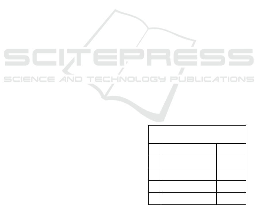
Transformation Rule
C' = [ [C - t(g(x))] + t(g(y)) in which C= initial
shape, t= transformation, x=Rule condition, y= Rule
conclusion
Table 1: Shape rule syntax.
C' = [C - t(g(x))] + t(g(y))
C'
New Shape
(visual)
C
Initial Shape
t
transformation
x
Rule condition
y
Rule Conclusion
Why shape grammars in cities?
Cities have been shaped through the century not only
by landscape or climate but by culture, social
A Strategic Approach to Smart Cities through CA and Shape Grammars
209
composition and daily life as well. All that create a
unique character that defines each city expressing all
the things that make it familiar to its citizens and
express their way of life.
Shape grammars can be helpful at the visual
representation of an existing condition that affects the
spatial interrelations of a city’s components, such as
the Built Environment - Natural Environment. After
the research parameters are set, the grammar can be
be applied analytically to a defined region in order to
discover the spatial rules that have been formed up to
that moment in the region. The problem can then be
decomposed to its basic requirements such as
physical elements, physical landscape, geodynamics,
buildings and urban expansion. Shape rules can be
derived from the interaction of the above and can be
used to study the elements’ behavior.
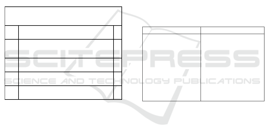
Table 2: Shape rule for Natural – Urban transformation.
C' = [C - t(g(x))] + t(g(y))
C'
Modern State
C
Initial Condition/ Natural State
t
transformation
x
Natural element
y
Urban Element
4.1.2 The SLEUTH Cellular Automaton
Model and Measuring Urban Data
SLEUTH is a CA model created to figure urban
development and land use change. SLEUTH is an
acronym for Slope, Land Use, Excluded Areas,
Urbanization, Transportation, and Hill shade, the
information layers that make the model run.
SLEUTH requires five inputs maps: urbanization,
transportation, areas excluded from urbanization,
slopes, and a hill shaded map (prepared using GIS and
then converted to 8 bit GIF images). For all these
layers, 0 is a null value, while all the values in-
between 1 and 255 are a measured value. The model
also requires that the input layers have the same
number of rows and columns and are correctly
dereferenced, as the model is sensitive to layer
misregistration. Urbanization is the most important
layer in the model, and for statistical calibration of the
model at least four urban time periods or spatial
extent ‘snapshots’ must be used.
The model works in the following way: after
reading the input layers, initializing random numbers
and controlling parameters, a predefined number of
interactions takes place that corresponds to the same
number of years. An outer loop executes each growth
history and retains statistical data, while an inner loop
executes the growth rules for a single year. After each
model run, sets of descriptive statistics are computed
and saved to a file for the purpose of calibration.
There are thirteen scores, and include: r2 population
(least squares regression score for the number of
urban pixels compared to actual urbanization for the
control years), edge r2 (least squares regression score
for the length of the urban-rural edge compared to
actual urbanization for the control years), r2 clusters
(least squares regression score for modelled average
urban cluster size compared to known mean urban
cluster size for the control years).
Table 3: Sleuth required input files.
MODEL
SLEUTH
REQUIRED INPUT
FILES
1.urbanization,
2.transportation,
3.areas excluded
from urbanization,
4.slopes, (besides the
slope, a constraint or
exclusion map
represents water
bodies, or natural and
agricultural reserves)
4.2 Conduit
4.2.1 How Shape Grammar Can Derive
Sleuth Rules for Spatial Configuration
As mentioned in (4.1.1) shape grammars can be used
analytically to visually express spatial properties of a
given problem and form shape rules that express
them, for example how does built environment
develop itself around existing rivers in a specific city?
The formation of such rules can help establish a
certain vocabulary of the case study region.
p.e
If ( C = initial condition){
If (river_not_covered){
riverbank();
builtEnvi();
SMARTGREENS 2019 - 8th International Conference on Smart Cities and Green ICT Systems
210

If (r_bank && b_Envi) {
If ((r_bank ∩b_Envi) ≠0){
Shape Rule Y1 = (Overlap_Shape);
Shape w1 = (r_bank – b_Envi);
Shape b1= (b_Envi-r_bank);
}
Else if ((r_bank ∩b_Envi) =0){
inBetween();
Shape Rule Y2 = (Inbetween_Shape);
}
Else () {
neighboring= true
}
}
Else() {
urbanEnvironment();
.
.
.
}
}
Table 4: Shape rules syntax for intervention strategy.
C' = [C - t(g(x))] + t(g(y))
C'
Desired condition
C
Current Condition
t
transformation rule based on Shape
Grammars
x
Element to be replaced
y
New element
Y1 and Y2 are shape rules while {w1,b1} are
subsets. More steps can be used in order to acquire
more properties such as riverBank (); which can be
used to define shape transformation of the river bank,
the kind of material that exists on the bank. In order to
complete the analysis and create a “language” one
needs syntax. Cellular automata come in to logically
define the neighboring properties of the shape’s
interrelations. More specifically, SLEUTH CA, can
help create a list of neighboring Logic Rules based on
the data of the SLEUTH method. The data are used as
parameters for the shape grammars. The purpose of
this cross referenced method is to create one, final, list
of rules, a language. This way the set of rules is
multilayered and holds properties spatial interrelations,
neighboring, materials, physical elements or even
social properties.
Once the analysis is completed and the problem has
been defined one can study the best strategy of
intervention and composition by using the language of
the existing region, creating a landscape that is familiar
to the city and works with it.
4.2.2 How a CA Model Can Direct Sleuth
Urban Rules
This Understanding spatial structure is one of the key
activities in picking up a comprehension of patterns
and process and in effectively anticipating their
working. CVCA builds on SLEUTH and builds up a
lot of countervailing methodologies to the urban
development dispensed by SLEUTH. This dynamic
association is valuable, since it permits urban
development produced by SLEUTH to be headed to
different territories where the techniques are not
connected. CVCA starts by surveying the underlying
condition of the scene, creating a few scene
measurements dependent on the underlying state, and
utilizing these measurements to choose and execute
the proper scene procedures. CVCA then interfaces
yearly with SLEUTH so as to have the scene
techniques upheld, along these lines managing
SLEUTH forward to 'great to-develop' regions, and
buffering essential environmental regions
distinguished by CVCA from anticipated urban
improvement. (Silva, Ahern, Wileden , 2008)
This is the principle motivation behind why the
CVCA show is named 'countervailing cellular
automaton'. It utilizes a lot of scene biological
methodologies to balance urban development to great
to-develop territories.
The CVCA demonstrate requires a similar info
layers as SLEUTH (Slope, Hill shade, Transportation,
Urban, Excluted). The excludes layer must be
changed altogether, in any case, so as to recognize an
alternate class that represents to every one of the
territories outside the boundary of the metropolitan
zones. These zones are avoided from urbanization,
yet for CVCA purposes they can't be viewed as a
similar kind of prohibition, since they don't figure in
the use of the natural techniques. The measurements
utilized were picked by the spatial indicators that
have been referenced in various landscape ecological
studies .
SLEUTH will work, in this way, as the
background of urban elements, where a lot of natural
elements needs to countervail. Through time, this
round of cooperation of urban– landscape will create
an alternate picture of the metropolitan territory,
where the requirements of urban development are
A Strategic Approach to Smart Cities through CA and Shape Grammars
211
fulfilled, however where environmental necessities
are likewise kept up, expanded or enhanced.
4.3 Affordance
The movement of the conduit is double at the level of
the switching, depending on the sign of the vector
objects located therein. Since the vector objects with
negative sign (-) are considered those whose size
deviation from the permissible limits (indicators) is
the highest, as indicated by the indices. In the second
selection step from said selected vector objects, we
chose to consider first those which the chart has
indicated from the outset that require special attention
against the particular way in which they are studies.
The CVCA yields four classes that coordinate five
diverse scene arranging methodologies (protective,
defensive, offensive, opportunistic, let it grow). As
examined in the presentation, it is imperative to build
up this sort of model, where urban and ecological
elements can be coordinated, taking into
consideration reenactments where both urban and
natural needs are considered and designated in a
feasible future.
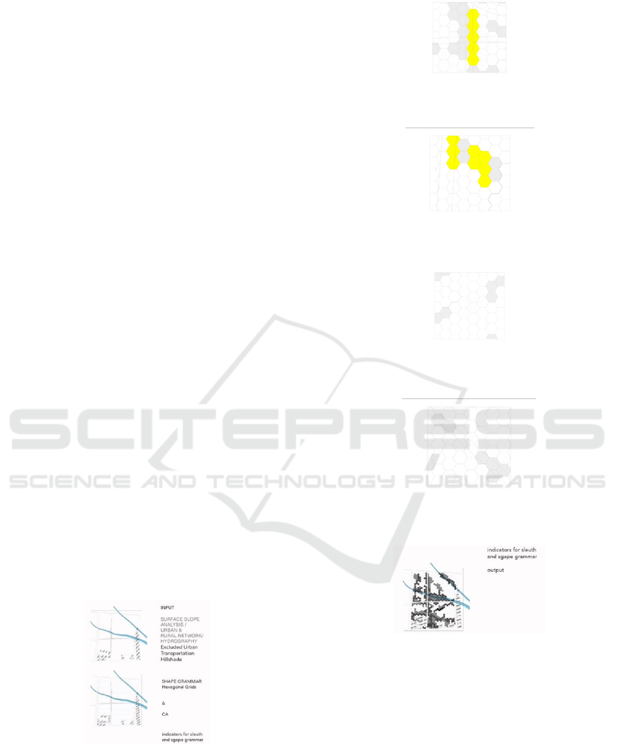
5 LARISSA AREA
Larissa, Greece is the territory of examination of the
exploration (Fig. 1). So as to more readily
comprehend the subsequent measurements inside the
alignment results and in this manner in the situations.
The case study was a landfill outside the city that was
meant to be an Agricultural Center and a Park. Since
the landfill was not occupied the stage of analysis
gave way to analytical approach of composition
through the use of Cellular Automata.
Figure 1: Sleuth and Shape Grammar required input files
and indicators.
Figure 2: Offensive strategy. Set up an external support to
the fix and a passage to its neighbor.
Figure 3: Defensive strategy. 50% (all cells are low
probability of change).
Figure 4: Opportunistic strategy. Establish corridor
between the fix and its neighbor.
Figure 5: Protective strategy. Establish corridor and create
outer buffer.
Figure 6: Output files.
The application of CA formed cells of 8 different
qualities, built areas, hard ground, soft ground, urban
water, non urban water, urban green, free space and
sports which are set with specific neighboring
properties. The next step was to use Shape Grammars
to bring these qualities into shape and turn them into
human scale spaces.
The main part of that study was the imprint of the
underwater veins on the surface and how that could
be a living space. Each Shape Rule is connected to a
neighboring condition of the CA.
SMARTGREENS 2019 - 8th International Conference on Smart Cities and Green ICT Systems
212
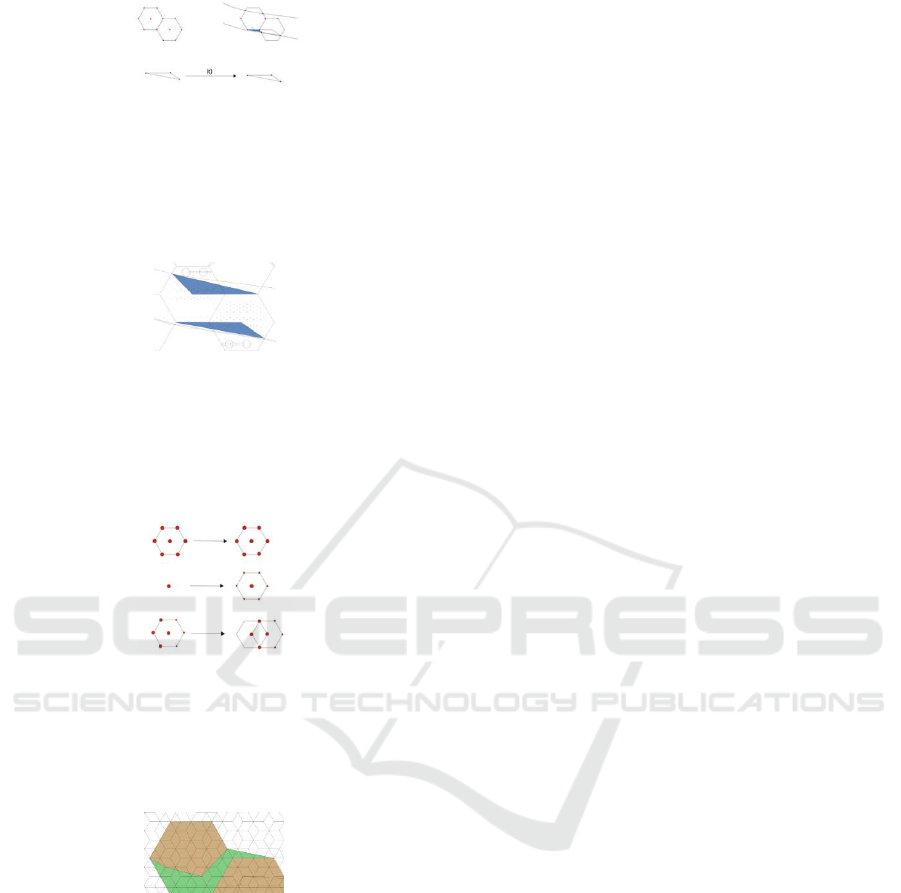
Figure 7: Shape rules for water points, the initial condition
is represented on the left. The initial condition is the
hexagon cell defined by its nodes. The first step is the
intersection of the cells with the water vein imprint which
gives us new nodes. The second rule is the application of
the triangle shape through transformation to the shape result
from the intersection.
Figure 8: Shape result.
Following the urban water cells, came the formation
of the ‘banks’ the neighboring cells according to the
CA results. The shape rules that were applied were
aimed at the formation of a landscape supporting the
strategy.
Figure 9: Shape rules for the landscape formation, initial
condition is on the left and shape result is on the right. After
the shape has been finalized there is one more step, that of
node interpolation. The shape results must not include more
than 3 neighbouring cells and must not intersect with more
than 3 of their segments.
Figure 10: Shape result example.
6 CONCLUSION
To sum up, if today the cultural consideration changes
looking for a smarter city, then design strategies
should move to manufacturing techniques that
manage change through ecological evolving and
developing platforms. On an effort to form a smarter
city, natural landscape should not be a backdrop on
which the urban articulation will be placed, but a
dynamic field of study, management and recovery of
the urban fabric. On this basis the research presented
in this paper a first conceptual approach to a
mechanism that may monitor the transformation of
natural space, fed with data obtained from its
analysis, in order to compose them and redefine the
urban space. It could be said that this mechanism acts
as a filter which not only receives information but
also checks if this information can be changed and
also produces connections and forms supported by
computer generated programs. Unlike traditional
urban fabric design methods, or the digitized form of
smart cities, this mechanism aims to produce a
smarter city through a renewed perception of
convergence of the aspect between man-made
environment and natural space.
This paper sets up the need to incorporate the natural
part in region planning, and featured landscape
ecology concepts as the proper reason for
environmental planning in urbanizing districts. The
gap between the hypothetical originations and the
practise of landscape is apparent; the advancement of
displaying approaches and the real usage of
coordinated metropolitan planning will in general be
ignored. While we can point to a few explanations
behind this gap, it is imperative to feature one of its
plausible main drivers: an holistic methodology
requires a complex system approach, so as to all the
more likely comprehend the procedures included and
to ensure that future urban structures are practical and
naturally generous; and the truth of the matter is that
we are utilized to deal with the issues and solutions.
By proposing an urban model (SLEUTH) that can
cooperate with landscape ecology model (CVCA)
and with a social-economic tool (Shape Grammar) so
as to propose plenty of arranging techniques that can
guide urban development, this paper is contributing
to the progress of research in and practise with
regards to landscape planning.
REFERENCES
Batty, M. (1999). Modelling urban dynamics through GIS-
based cellular automata. Computer Environment and
Urban Systems, 23, 205–233.
Batty, M., Xie, Y., and Zhanli, S. (1999). Modellng urban
dynamics through GIS-based cellular automata.
Computers, Environment and Urban Systems, 23, 205–
233.
Batty, M. (1996). Fractal cities. London: Academic
Press.Batty, M. (2005). Cities and complexity.
Cambridge, MA: The MIT Press.
Corner, J. 2003. Landscape Urbanism. In Landscape
Urbanism: A Manual for the Machinic Landscape.
Architectural Association.
Clarke, K. (1998). Loose-coupling a cellular automaton
model and GIS: Long-term urban growth prediction for
A Strategic Approach to Smart Cities through CA and Shape Grammars
213

San Francisco and Washington/Baltimore. International
Journal of Geographic Information Science, 12(7),
699–714.
Clarke, K., Hoppen, S., and Gaydos, L. (1997). A self-
modifying cellular automaton model of historical
urbanization in the San Francisco Bay area.
Environment and Planning B: Planning and Design, 24,
247–261.
Hays, M., 1968. Architecture Theory since, Cambridge
MA: the MIT Press Journal, London, England.
Lister, N-M., 2007. Sustainable Large Parks. In Czerniak,
J. & Hargreaves, G. (ed.) Large Parks. New York:
Princeton Architectural Press.
Macdonald, C., 2006. Machines of Loving Grace. In On
Landscape Urbanism. Austin TX: Center for American
Architecture and Design University of Texas at Austin
School of Architecture.
Mitchell, W. J., 2006. Smart City 2020. Metropolis,
April.Availableathttp://www.metropolismag.com/story
/20060320/smart-city- 2020.
Moore, R., Lopes, J., 1999. Paper templates. In
TEMPLATE’06, 1st International Conference on
Template Production. SCITEPRESS.
Νeuman, M., 2006. Infiltrating infrastructures. Journal of
Urban Technology,131.
Kotsopoulos 2008, From Design Concepts to design
descriptions, International Journal of Architectural
Computing, issue 3, vol.6
Simon, H.A., 1996.The Science of the artificial. MIT Press:
Cambridge, Mass, 3rd edition.
Silva, E. A. (in press). ‘Complexity and CA, and application
to metropolitan areas’. In: G. de Roo, and E. A. Silva,
A planner’s meeting with complexity. Aldershot, UK:
Ashgate Publishers Ltd.
Silva, E. A. Ahern, Wileden (in press). ‘Strategies for
landscape ecology: An application using cellular
automata models ’.
Smith, J., 1998. The book, The publishing company.
London, 2
nd
edition.
Stiny, G., 1980. Introduction to shape and shape grammars.
Environment and planning B: planning and design,
7(3), pp.343-351.
Steiner, F. R., 2006. Living Urban Landscapes, In On
Landscape Urbanism. Austin TX: Center for American
Architecture and Design University of Texas at Austin
School of Architecture.
Speller, T. H., Whitney, D., and Crawley, E. (2007). Using
shape grammar to derive cellular automata rule
patterns. COMPLEX SYSTEMS-CHAMPAIGN-
, 17(1/2), 79
Vianna, M.M.B., Portugal, L.S., Balassiano, R., 2004.
Intelligent transportation systems and parking
management: implementation potential in a Brazilian
city, Cities, 21(2).
Waldheim, Ch., 2006. Landscape as Urbanism. In the
Landscape Urbanism Reader. Princeton Architectural
Press.
SMARTGREENS 2019 - 8th International Conference on Smart Cities and Green ICT Systems
214
