
Effective Remote Drone Control using Augmented Virtuality
Kamil Sedlmajer, Daniel Bambu
ˇ
sek and V
´
ıt
ˇ
ezslav Beran
Brno University of Technology, Faculty of Information Technology, Centre of Excellence IT4Innovations,
Bozetechova 1/2, Brno, 612 66, Czech Republic
Keywords:
Augmented Virtuality, UAV, Drone Piloting, Virtual Scene, Navigation Elements, First Person View, Third
Person View.
Abstract:
Since the remote drones control is mentally very demanding, supporting the pilot with both, first person view
(FPV) and third person view (TPV) of the drone may help the pilot with orientation capability during the
mission. Therefore, we present a system that is based on augmented virtuality technology, where real data
from the drone are integrated into the virtual 3D environment model (video-stream, 3D structures, location
information). In our system, the pilot is mostly piloting the drone using FPV, but can whenever switch to TPV
in order to freely look around the situation of poor orientation. The proposed system also enables efficient
mission planning, where the pilot can define 3D areas with different potential security risks or set naviga-
tion waypoints, which will be used during the mission to navigate in defined zones and visualize the overall
situation in the virtual scene augmented by online real data.
1 INTRODUCTION
Nowadays, the use of unmanned aerial vehicles
(UAVs) extends to a wide range of areas, from res-
cue services and police forces to the commercial sec-
tor. Drones are used to monitor the quality of high
voltage structures, the development of infrastructure
outages, or to support complex interventions by res-
cue or police units. In all cases, the use of a drone
requires high skill and mental demand for the drone
operator.
Recent research let arise to various autonomous
modes, where the drones are able to perform a pre-
cisely predefined mission independently and without
the need for operator intervention. Unfortunately, to-
day there is no problem in solving a wide range of
tasks with the autonomous capability of the drone,
but with the operator’s legal constraints. For this rea-
son, it is necessary to look for a different solution.
This article deals with solving this situation by link-
ing autonomous drone functions to operator control.
The article seeks to reduce the operator’s mental load
in controlling drone in action using semi-autonomous
drone functions.
Legal constraints today do not allow the full use
of autonomous drone functions. Similarly, existing
drone control solutions are now extremely burden-
some for the operator. Orientation in space, keeping
in safe zones, tracking key mission points, all of this
makes the operation of the drone operator quite chal-
lenging.
Based on the study of existing tools and published
results in the field, supported by own drone control
experience, this work aims to define the key attributes
of attention to the drone’s operator and proposes a
range of visualization and interactive features to re-
duce the drone operator’s mental load, using aug-
mented virtuality.
The key elements, that this study builds on, are the
use of available topography maps, elevation maps, 3D
data and virtual objects to enhance mission navigation
clarity. The proposed solution combines existing data
sources into a 3D virtual scene, augmented by on-
line drone camera video-stream and other drone sen-
sor data, as well as user-defined virtual objects such
as safe zone boundaries or key points of a planned
mission.
2 RELATED WORK
With an increasing popularity of drones, new effec-
tive methods for piloting them are emerging. Some
are concentrating solely on autonomous flights with
autonomous obstacle avoidance algorithms (Gageik
et al., 2015) and (Devos et al., 2018), others are fo-
cusing on various user interfaces for manual drone
Sedlmajer, K., Bambušek, D. and Beran, V.
Effective Remote Drone Control using Augmented Virtuality.
DOI: 10.5220/0008349401770182
In Proceedings of the 3rd International Conference on Computer-Human Interaction Research and Applications (CHIRA 2019), pages 177-182
ISBN: 978-989-758-376-6
Copyright
c
2019 by SCITEPRESS – Science and Technology Publications, Lda. All rights reserved
177

controlling, such as gesture-based, voice-based, or re-
mote controllers along with head-mounted displays
(HMD). Recently, there were some experiments for
controlling drones using brain-computer interfaces
(Nourmohammadi et al., 2018) and (Mamani and
Yanyachi, 2017). More common are attempts of di-
rect drone control using gestures, which are detected
with use of vision based methods from either drone
attached cameras (Fern
´
andez et al., 2016), (Natara-
jan et al., 2018) or from additional hand tracking
devices, such as the Leap Motion (Gubcsi and Zse-
drovits, 2018). Unfortunately, such approaches are
usable only for piloting the drone within a close dis-
tance rather than piloting it remotely. When piloting
the drone remotely, but still from a visible distance,
using some remote controller, it is often difficult to
distinguish the drone’s front face, which causes high
workload on the operator. In order to lower this work-
load, Cho et al. introduced an egocentric drone con-
trol approach, which keeps the drone’s back face au-
tomatically rotating towards the operator, who is pi-
loting the drone from his/hers perspective (Cho et al.,
2017).
To enable the user to control the drone completely
remotely, without directly observing it, it is crucial to
provide the user some sort of vision from the drone
perspective. Currently, there are many commercially
available products that are able to transmit the image
from the drone attached camera into either the HMD,
handheld display or regular screen in order to provide
the first person view (FPV) for the operator. However,
most of them only sends monocular video feed, which
is insufficient in terms of perceiving distances, depths
and proportions inside the FPV. The solution to over-
come this problem has proved to be the attachment of
two cameras to the drone to enable the stereoscopic
vision inside the HMD (Smolyanskiy and Gonzalez-
Franco, 2017).
Using remote controllers require attention and de-
veloped skills during piloting. Replacing them with
wearable interfaces, such as exoskeleton suit with
smart glove, could enable a more natural and intu-
itive drone control, where the operator feels more im-
mersed (Rognon et al., 2018). Unfortunately, the op-
erator could still struggle with awareness of drone sur-
roundings that are out of drone camera’s field of view
(FoV). There comes in place the idea of placing the
camera image into a virtual environment model, in or-
der to extend the limited FoV (Calhoun et al., 2005).
The image, along with the virtual model, can be aug-
mented with waypoints, danger zones or points of in-
terest. We believe that enabling the operator to when-
ever switch from the FPV into a third person view
(TPV), where he/she can see whole drone situated in
a virtual environment, should improve operator’s sit-
uation awareness and reduce the mental load.
3 PROPOSED INTERFACE
The main goal of this work is to design a visualiza-
tion system and navigation elements that will reduce
the operator’s mental strain when piloting the drone
over longer distances. We define the following key
attributes and how to resolve them:
1. Off-line and on-line spatial and sensory data fu-
sion.
2. Virtual cameras.
3. Navigation or security structures.
Operator orientation might be improved by the
TPV. The presented solution is based on virtual 3D
scene augmented by real on-line data registered and
visualized in the virtual scene (Augmented Virtuality).
The 3D scene is created from the available free map
data sources (topological, elevation). The 3D model
of the drone inserted to the scene is controlled (posi-
tion and orientation) by the data transmitted from the
real drone. A video-stream from the camera on the
drone is also rendered to the virtual scene. All com-
bined spatial data must be properly registered into a
local coordination frame. The pilot is then able to
control the drone as usual (FPV), but can also unlock
the camera and move to the TPV and see the drone
and its surroundings. The operator’s FoV is signifi-
cantly expanded. This concept is depicted in the Fig-
ure 1.
The rendering of the video-stream to the vir-
tual scene can be realized in several different ways.
The first is to project it into a huge virtual screen (see
Figure 1). The screen size depends on the FoV of
the physical camera with either a plane or a suitably
curved surface. The screen is moving at a fixed dis-
tance from the drone and follows the drones’ position
and orientation. The other option is to project the im-
age directly onto objects in the scene. The usability of
the video projection onto virtual scene requires very
precise registration between the 3D virtual scene and
the drone.
Virtual cameras in the 3D scene provides the
user with ability to look into the scene from any view-
point and to manipulate the camera freely. E.g. the
operator can stop the drone in a safe position (safe dis-
tance from the obstacle) and move around the scene
by flying with the virtual camera. When the virtual
camera is fixed, the operator can switch back to con-
trol the drone and observe the scene from a new vir-
tual position.
CHIRA 2019 - 3rd International Conference on Computer-Human Interaction Research and Applications
178
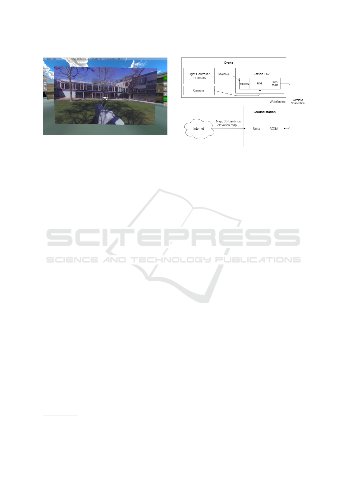
Figure 1: Concept of controlling the drone from the third
person view. The virtual screen (with the video feed) moves
at a certain distance in front of the drone and is synchro-
nized with the physical gimbal configuration.
Another way to increase the safety of remote
drone control is visualization of other sensor data,
such as depth data, usually presented by 3D point
cloud, that samples outer surfaces of objects around.
This data significantly refine and complement the
world model created from off-line data and allow the
pilot to have a much better overview of the static
obstacles around the drone, such as trees, buildings,
cars, etc.
The use of augmented virtuality further provides
the operator with the ability to add navigation or se-
curity structures to the scene. One such element
may be virtual walls. These can define a space in
the scene, such as unauthorized entry or a safe zone.
Since such zones are often up to a certain height, dis-
playing them in 3D scene is far more perspicuous than
displaying them on a 2D map.
Another elements, e.g. for a flight in a more com-
plex environment with a number of obstacles, are
navigation arrows that point to waypoints. As a re-
sult, the pilot will always know which direction to fly
and the task is just to avoid the obstacles. These way-
poins can be placed not only on the ground, but also at
a specific height in the air. The application should also
be able to navigate back to the starting point and the
pilot should be able to display both navigation arrows
at once. One will point to the starting point, the other
to the current waypoint. In addition to the arrows, the
distance to a given point may also be displayed.
4 SYSTEM ARCHITECTURE
The testing application was developed using the Unity
game engine. For creating the 3D virtual envi-
ronment, we used the plugin MapBox
1
. The plu-
1
https://docs.mapbox.com/unity/maps/overview/
Figure 2: Communication between the drone and the
ground station. On the application side, the ROS# library
communicates with the drone via Rosbridge, where the data
are transmitted via the WebSocket protocol. The applica-
tion also automatically downloads maps, 3D buildings and
heightmaps from the Internet.
gin automatically loads the environment maps and
heightmaps in order to create the terrain in Unity.
MapBox also includes several map layers with 3D
building models, which are not perfect (rough build-
ing shapes, approximate heights, unrealistic textures
or fake rooftop shapes), but they are still sufficient for
our proof of concept. For a better quality virtual en-
vironment, virtual objects and textures from Google
Maps, which are currently the best on the market,
could be used. However, Google does not provide
them to third parties yet.
For a successful combination of the virtual scene
with the real drone, it is necessary to transmit follow-
ing data from the drone into the ground station:
• Drone’s position (pair of coordinates in WSG84
format).
• Drone’s rotation (yaw – angle obtained from an
electronic compass on the drone; pitch and roll).
• Compressed drone-attached camera stream.
• Drone-attached camera rotation (in respect to the
drone).
• Other available sensor data (e.g. point cloud, bat-
tery status, flight speed, flight mode).
The method is based on 3D virtual scene model.
The 3D virtual data are integrated from existing data
sources and the coordination system is registered to
actual real drone position. The GPS drone coordi-
nates and orientation data is used for registration with
virtual 3D frame. The augmentation of the virtual 3D
scene is achieved by rendering the live video-stream
from the drone front camera to projection plane in
front of the virtual drone. The video latency is an im-
portant issue and highly influence the quality of the
Effective Remote Drone Control using Augmented Virtuality
179
interaction with the proposed system. The video la-
tency hardly depends on the quality of the WiFi sig-
nal, i.e. distance between the drone and the station.
The additional navigation UI elements, like mission
points, direction to next point or virtual walls, are ren-
dered into virtual scene and presented to the user. The
registration method might be improved by computer
vision techniques, but this step will be considered
later according to user tests, when the effect of rough
GPS and compass based registration and caused video
latency will be considered by professional pilots as an
important issue.
The communication protocol is dependent on the
drone manufacturer, drone’s control unit and used
software. In order to have customization possibil-
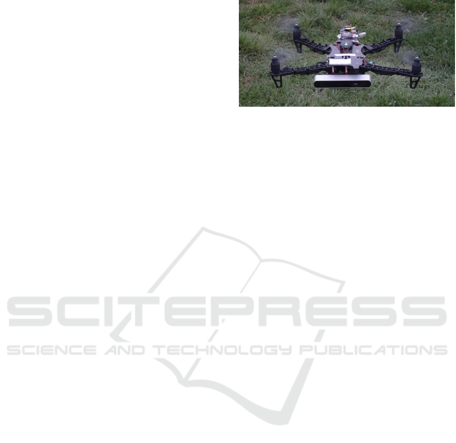
ities, we built our custom experimental drone (see
Figure 3), which comprises of the Pixhawk control
unit with PX4 Autopilot software, Nvidia Jetson TX2
with the Ubuntu OS, stereoscopic camera, GPS and
a compass. We chose the communication over WiFi
between the drone and the base station. WiFi com-
munication is limited in transmit distance, but has a
high data throughput. The PX4 Autopilot uses the
MAVlink communication protocol, which is trans-
ferred into the MavRos protocol of the ROS operating
system (running on the Nvidia Jetson) over the Ros-
bridge tool. The communication scheme is depicted
in the Figure 2. The system architecture is described
in more detail in (Sedlmajer, 2019).
5 RESULTS
A test application was created with the implementa-
tion of several basic elements described in the pre-
vious chapter; and several real drone tests were per-
formed. Since it was only an experimental platform
with a gimbal-free camera and connection to a ground
station via WiFi, which was limited in scope, it was
only possible to perform the testing with limited re-
strictions. In spite of this, it was possible to try out
a few basic use cases where the tests showed that the
concept works and it is possible to control the drone
with it. The application was built and tested on a lap-
top.
5.1 Test 1: Monitoring the Area Where
the Drone Must Not Fly
When using a drone, for example, in the service of the
police, it is often necessary to monitor an area (road,
demonstration area, etc.). However, the police must
also comply with the legal constraints, therefore their
Figure 3: Test drone with Pixhawk control unit, ZED stereo-
scopic camera and Nvidia Jetson supercomputer, shot just
above ground.
drones must not be flown, for example, near a high-
way or over a square full of people. If a pilot wants to
use the drone to track the area, but to keep it out of its
protective zone, he must constantly check where the
drone is.
The first designed test flight was supposed to
check whether adding virtual walls, representing bor-
ders of such areas, would help the pilot stay on their
edge while observing what is happening around.
Virtual transparent walls were very useful in this
test when flying inside the area, because the pilot sees
clearly that he is approaching the border, or that he has
just flown through it (see Figure 4). But the flight at
the walls’ border proved surprisingly difficult. When
flying near these walls (about 5-8 m) it is really hard to
estimate their distance. Therefore, it would be useful
to hide them and display only the nearest part of the
border when the drone really approaches it. The sec-
ond option could be to gradually make the walls more
transparent if the drone moves away from them. Most
clearly, the part of the border that is closest to the
drone would shine, the distant parts would be com-
pletely hidden. So if the pilot saw a glowing grille in
front of him, he would know with absolute certainty
that the border is very close. The distance, at which
the boundary would appear, would be good to adjust
to the speed at which the drone is approaching it, so
that the pilot always has enough time to react, but at
the same time the boundary does not unnecessarily
interfere with the pilot’s vision.
Another problem was the blending of the virtual
wall with a virtual screen that was distracting and un-
pleasant. But even the proposed solution could at
least partially solve this problem, because only the
part of the boundary that is really needed at that mo-
ment would always be displayed.
CHIRA 2019 - 3rd International Conference on Computer-Human Interaction Research and Applications
180
5.2 Test 2: Exploration of a Distant
Object and Flight between
Obstacles
This test mimicked another fairly common task – ex-
ploring a more distant object (such as a house or a
parked car) that is too far away from the drone, caus-
ing the pilot to fly closer to it. Here, the aim was to
test whether the application really could help to im-
prove the pilot’s spatial orientation during the flight
to this location, the object being explored, and the re-
turn to the starting point. In this test, it was assumed
that the pilot knows the position of the object in ad-
vance and can create a waypoint on the object’s po-
sition and navigate to it. The second part of the test
was a low altitude flight between obstacles, when it is
not possible to use an autonomous flight, but the pi-
lot must manually get through a lot of obstacles (e.g.
trees) and not to lose the spatial orientation and di-
rection of the flight even with no landmarks around.
It is not possible to use map data in this mode, be-
cause it is necessary to fly using a video only in order
to watch obstacles carefully. Here, however, naviga-
tion arrows could help, because they keep the pilot in-
formed about the direction to the waypoint and back
to the starting point. This allows the pilot to accom-
plish the task faster.
When testing a remote object survey, an object
was placed on the ground at a distance of approxi-
mately 60 m from the starting point, and a waypoint
was created at that point. Between the starting point
and this point was an asphalt cycle path and several
rows of freshly planted young trees that created nat-
ural obstacles. Since there were only meadows and
low trees nearby, there were hardly any natural land-
marks. Orientation only by the poor quality video
stream was very demanding. However, during this
test, the navigation arrows, which performed perfectly
in their role, had greatly facilitated spatial orienta-
tion and significantly helped to reduce cognitive stress
during driving. It was not necessary to search for nat-
ural landmarks, it was enough to observe nearby ob-
stacles, a navigation arrow and a gradually decreas-
ing distance to the destination. After a while, a target
point indicator appeared on the ground.
But at this stage, there was a problem, because the
target waypoint was constantly traveling the ground
a few meters in all directions from a relatively small
target. This was probably due to the inaccuracy of
GPS navigation. In an effort to circumvent the exam-
ined object and explore it from all sides, the constant
movement of this point and the confused rotation of
the arrow was very annoying and confusing. Surpris-
ingly, this subject was complicated.
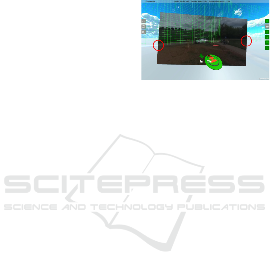
Figure 4: Screen of the implemented application based on
augmented virtuality. The virtual environment model is
augmented with the data from the real drone – position and
orientation, which are used to render the virtual drone in
the scene; camera image that is aligned with the virtual en-
vironment model (marked with the red circles); and other
sensor data. This environment model can be enriched by
virtual walls (the green grille) that can mark restricted areas
or with a waypoints and direction arrows.
It was much easier to do the fly around and survey
with the navigation arrow turned off, by video only.
At this point, it would probably be better if the nav-
igation elements were automatically hidden after ar-
riving close to the target and appeared again only if
the drone moved away from the target again.
On the other hand, the second arrow pointing to
the starting point could be used for orientation, as a
some sort of compass that makes clear how the drone
is being turned. In addition, for a pilot, a pointer to
the starting point is somewhat more natural than an
ordinary compass pointing to the north.
5.3 Discussion
Overall, the implemented application was relatively
pleasant to use and the fact that it was able to partially
compensate the absence of gimbal was positively ap-
preciated. Indeed, by moving the video according to
the current tilt of the drone, the objects on the video
were still displayed at approximately the same loca-
tion in the scene. Of course, the convenience of using
the application was reduced by controlling the cam-
era’s rotation with the arrow keys of the laptop key-
board. This convenience could be increased by con-
nection of VR glasses with head-tracker, which would
allow the pilot to naturally look around the scene.
On the other hand, the application did not work
very well at very low altitudes (up to 3 m), where the
flight altitude and the distance from smaller objects
were very poorly estimated. However, this problem
also occurs in the first person view (FPV). Surpris-
ingly, adding a drone model to the scene did not re-
Effective Remote Drone Control using Augmented Virtuality
181

duce the problem, but slightly increased it.
Quite surprisingly, the virtual screen with the cam-
era image was relatively well-connected to the virtual
scene most of the time, which even slightly exceeded
expectations, especially given that the test drone cer-
tainly did not have the most accurate sensors avail-
able. Professional drone data is likely to be even more
accurate.
The further development will be primarily focused
on solving problems that were discovered during test-
ing and on other designed ideas that were not imple-
mented (e.g. the visualization of other sensor data,
the point cloud, and the completion of area boundary
visualization). Then, VR glasses with a head-tracker,
which allows natural looking around the scene, will
be connected to the application. Another such thing
is to implement a free camera and test its capabilities.
6 CONCLUSIONS
The aim of this work was to improve pilot’s orienta-
tion and to reduce his mental load during the drone
remote control. Based on research and experience,
a system has been designed that is based on aug-
mented virtuality, where on-line data from drone sen-
sors (video-stream, flight data, etc.) are integrated
into the virtual environment model. The 3D vir-
tual model consists of the data from external data
sources like topography maps, elevation maps and
3D building models. The model also includes the
user-specified planned mission information like way-
points, safe zone boundaries or flight directions.
The system architecture is designed to be scalable
to communicate with multiple drones simultaneously.
This could be useful in situations where more pilots
are simultaneously carrying out a mission and have to
work together.
The preliminary user tests proved that the pro-
posed concept and technical implementation of the
entire system improves the operator’s orientation and
navigation skills and so reducing the mental load.
More user tests are planned in future work. The pro-
fessional pilots will test the system to refine the con-
cept, to improve or include more UI elements and for
further development based on their needs.
ACKNOWLEDGEMENTS
The work was supported by Czech Ministry of Educa-
tion, Youth and Sports from the National Programme
of Sustainability (NPU II) project “IT4Innovations
excellence in science – LQ1602” and by Ministry of
the Interior of the Czech Republic project VRASSEO
(VI20172020068, Tools and methods for video and
image processing to improve effectivity of rescue and
security services operations).
REFERENCES
Calhoun, G., H. Draper, M., F Abernathy, M., Delgado, F.,
and Patzek, M. (2005). Synthetic vision system for
improving unmanned aerial vehicle operator situation
awareness. Proceedings of SPIE - The International
Society for Optical Engineering, 5802.
Cho, K., Cho, M., and Jeon, J. (2017). Fly a drone safely:
Evaluation of an embodied egocentric drone controller
interface. Interacting with Computers, 29(3):345–
354.
Devos, A., Ebeid, E., and Manoonpong, P. (2018). De-
velopment of autonomous drones for adaptive obsta-
cle avoidance in real world environments. In 2018
21st Euromicro Conference on Digital System Design
(DSD), pages 707–710.
Fern
´
andez, R. A. S., Sanchez-Lopez, J. L., Sampedro, C.,
Bavle, H., Molina, M., and Campoy, P. (2016). Nat-
ural user interfaces for human-drone multi-modal in-
teraction. In 2016 International Conference on Un-
manned Aircraft Systems (ICUAS), pages 1013–1022.
Gageik, N., Benz, P., and Montenegro, S. (2015). Obstacle
detection and collision avoidance for a uav with com-
plementary low-cost sensors. IEEE Access, 3:599–
609.
Gubcsi, G. and Zsedrovits, T. (2018). Ergonomic quad-
copter control using the leap motion controller.
In 2018 IEEE International Conference on Sens-
ing, Communication and Networking (SECON Work-
shops), pages 1–5.
Mamani, M. A. and Yanyachi, P. R. (2017). Design of com-
puter brain interface for flight control of unmanned air
vehicle using cerebral signals through headset elec-
troencephalograph. In 2017 IEEE International Con-
ference on Aerospace and Signals (INCAS), pages 1–
4.
Natarajan, K., Nguyen, T. D., and Mete, M. (2018). Hand
gesture controlled drones: An open source library.
In 2018 1st International Conference on Data Intel-
ligence and Security (ICDIS), pages 168–175.
Nourmohammadi, A., Jafari, M., and Zander, T. O. (2018).
A survey on unmanned aerial vehicle remote control
using brain–computer interface. IEEE Transactions
on Human-Machine Systems, 48(4):337–348.
Rognon, C., Mintchev, S., Dell’Agnola, F., Cherpillod,
A., Atienza, D., and Floreano, D. (2018). Fly-
jacket: An upper body soft exoskeleton for immersive
drone control. IEEE Robotics and Automation Letters,
3(3):2362–2369.
Sedlmajer, K. (2019). User interface for drone control using
augmented virtuality. Master’s thesis, Brno University
of Technology, Faculty of Information Technology.
Smolyanskiy, N. and Gonzalez-Franco, M. (2017). Stereo-
scopic first person view system for drone navigation.
Frontiers in Robotics and AI, 4.
CHIRA 2019 - 3rd International Conference on Computer-Human Interaction Research and Applications
182
