
MINDROAD
Route Memory Support System using a Smart Phone
Taiki Ueno and Michiaki Yasumura
School of Media and Governance, Keio University, 5322 Endo, Fujisawa-shi, Kanagawa, 252-0882, Japan
Keywords: Map, Google maps, Photo, Smart phone, GPS, Memory, Distance, Route.
Abstract: Ideally, when one is going to a destination when knows how to get there. But, even if one doesn’t know the
way in detail, having a sense of the direction and roughly how to get there is very helpful. One can also ask
for directions from other people or use tools such as maps and navigation systems. However, there is always
a risk of getting lost, getting given the wrong directions, or having a tool be unavailable (e.g., because a
Website is down or a device runs out of batteries). Thus knowing the way to destinations is useful
knowledge. In this research, we have developed a prototype system that helps users memorize the route to
their destination more easily. With this system, the user first taps the starting point and the goal point in the
map on a smart phone. Then, the route is shown, and views of important waypoints such as major
intersections are reproduced continuously. In addition, we propose a method for automatically detecting
routes that users often pass, as well as similar routes to the current one.
1 INTRODUCTION
In general, when one moves to an unfamiliar
destination on foot, one often consults a map in
advance and/or consults a map intermittently while
going to the destination. For consulting maps, many
convenient tools exist, such as Google Maps and
Google Street View. However, people with a poor
sense of direction may have difficulty using such
tools. In addition, these tools do not make it easy to
memorize the routes to destinations in advance.
Even if one has studied the route carefully, when
actually walking in the route to the destination, you
may experience uncertainty about whether one is on
the right road or has made the right turn. Even when
following a map, if one makes a mistake, or
confuses one landmark for another, it can be very
difficult to recover from the error and get back on
track. There may be a mismatch between
information on a map and the landmarks that you
have stored internally, and you may confuse
distances based on an incorrect sense of scale on the
map. Similar things can happen even if you are
walking while actually looking the map. If you use
Google Street View, it might be easy to figure out
where to go next when one has the right view, but it
may be difficult or time consuming to find the view
that is needed.
In addition, there are the way-finding mobile
navigation systems that based on GPS. However,
such systems have problems, for example, people
can’t move smoothly to the destination (Ishikawa, et
al., 2008).
People who have lost their way may not be able
to access a cognitive map in their own brain
(
Shingaki, 1998). Using tools like maps, to the extent
that it externalizes the way-finding task, is unlikely
to encourage the development of route memory.
Training is needed to build cognitive maps (Sadalla
and Montello, 1989).
In order to facilitate formation of cognitive maps
we have developed a prototype system, called
MindRoad that helps people memorize the route to a
destination more easily. In this system, the user first
taps the starting point and the goal point in the map
of a smart phone. Then, the route is shown, and
views of important waypoints such as major
intersections are reproduced continuously. In
addition, we propose a method for automatically
detecting routes that users often pass, as well as
similar routes to the current one.
2 RELATED WORK
In one way-finding system, the system provides rou-
306
Ueno T. and Yasumura M..
MINDROAD - Route Memory Support System using a Smart Phone.
DOI: 10.5220/0003399503060308
In Proceedings of the 1st International Conference on Pervasive and Embedded Computing and Communication Systems (PECCS-2011), pages
306-308
ISBN: 978-989-8425-48-5
Copyright
c
2011 SCITEPRESS (Science and Technology Publications, Lda.)
te guidance, and an augmented reality view is
displayed on the Google Street View (Tokusho and
Feiner, 2009). The system supports the route guide
by a smart phone.
In another approach, the system presented that
uses images of user’s place maps taken with a GPS-
enhanced mobile camera phone as background maps
for on-the-fly navigation tasks (Schöning et al.,
2009).
Moreover, the user uses a special device called
the Active Belt which indicates the direction that
should be taken through vibration (Tsukada and
Yasumura, 2004). Uses follow the directions
indicated by the direction of vibration to reach the
destination.
Recently, a system that helps people meet up at a
common location has been proposed for a smart
phone device to be carried and consulted while
moving to the destination (William, et al., 2010). In
our research we are taking an alternate approach of
strengthening route memory prior to actually going
to the destination.
3 PROPOSAL OF MINDROAD
This section explains the concept and the
implementation of our prototype system.
3.1 System Design
In this research the use case involves searching for
the route to a destination in advance of actually
going to the destination. We propose a system that
supports the memory of the route, and we have
developed a prototype to test the concept. This
system operates according to the following
procedures.
(1) The map around the destination is displayed on a
smart phone.
(2) When you tap on the map, the starting point is
set.
(3) Afterwards, when you tap on the map, the goal
point is set.
(4) The route from the starting point to the goal
point is shown in the map.
(5) At the same time, the image of the starting point,
the turning points on the way, and the goal point is
continuously reproduced and is shown to the user.
The images are presented by using the Google Street
View.
As mentioned above, the system supports the
development of route awareness when the map of
the destination is examined in advance by
continuously reproducing the views showing the
landmarks. The system allows mental images to be
associated with locations on the route.
3.2 Implementation
We implemented the system by JavaScript. The
system acquires the map information and the
location information by using Google Maps API.
The latitude and longitude of the starting point and
the goal point where the user tapped on the map is
acquired. The system infers the route by using the
latitude and longitude of the starting point and the
goal point. And the system then presents the route
on map. After this, the system acquires the latitude
and longitude of each corner in the route to construct
a set of landmarks. Views acquired from the Google
Street View API, corresponding to locations on the
route, are then shown as the route is followed. The
view of each position is displayed for three seconds
in the current version of the system. The views are
displayed in order from the starting point to the goal
point.
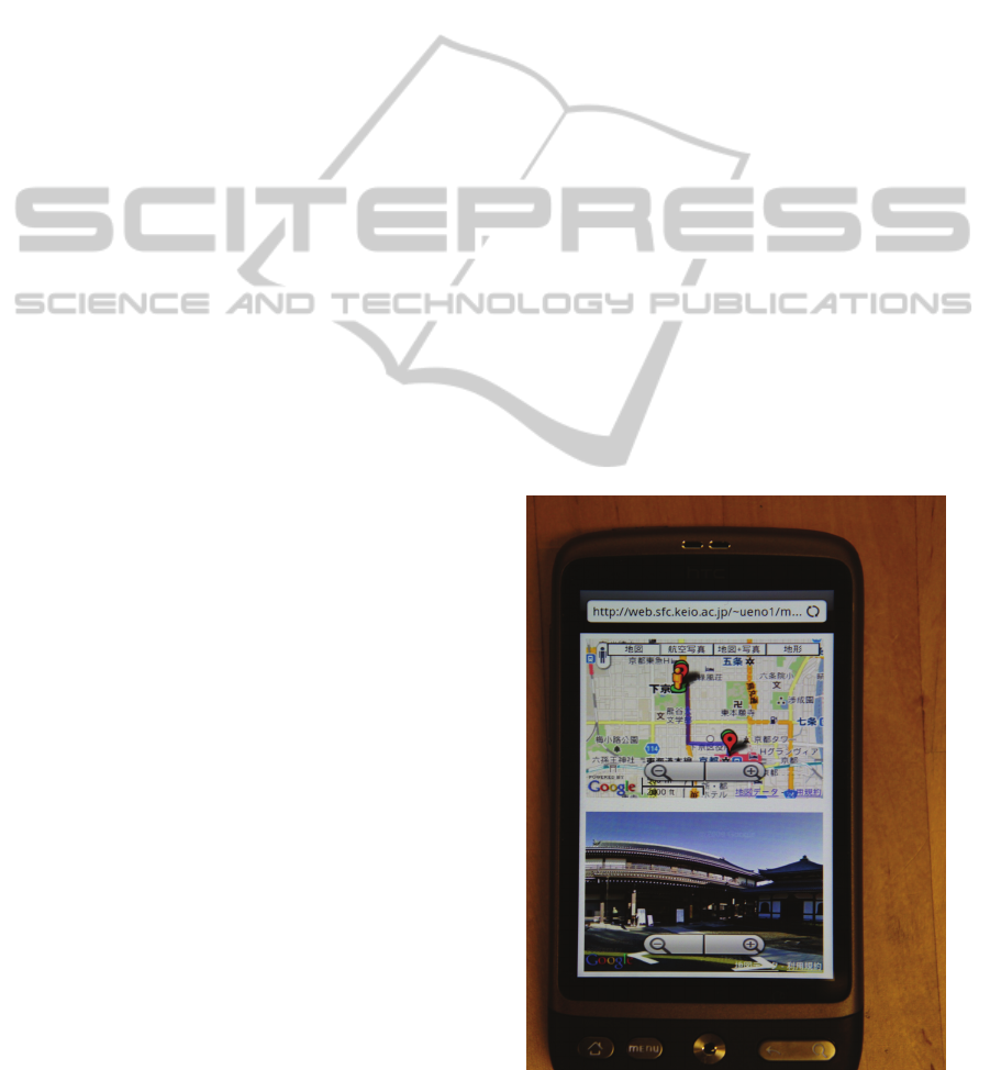
Figure 1 is an example of the display when the
route from Kyoto Station to Nishi-Hongan-ji, in
Kyoto city in Japan. A smart phone in the
photograph in Figure 1 is HTC Desire Android
phone.
Figure 1: Capture Image of the System.
MINDROAD - Route Memory Support System using a Smart Phone
307

3.3 Future Work
In this paper, we presented a system developed to
supports route awareness by helping people to link
street views to locations along a route. The future,
we will develop when using the system, the roads
that the user passed are preserved in a local data
base used by GPS information on the smart phone.
Afterwards, when the user goes to the destination the
system compares the current route with past data,
and a similar route to the past route is presented.
Figure 2 shows the mechanism by which a similar
route is acquired. First, the system store the way
where the user walk usually, used GPS log. The
system use that GPS log information, and when the
user newly search the destination, the system
presents the way that looks like the destination well.
Figure 2: Mechanism for Finding a Similar Route.
4 DISCUSSION
While navigation systems using GPS information
have evolved rapidly, the perfect navigation system
has yet to be invented. Thus maintaining a good sen-
se of direction remains a useful skill.
People with a poor sense of direction tend not to
routinely memorize landmark and corner
information (Shingaki, 1998). The system described
in this paper shows continuous views along a route
that are linked to corresponding locations. Using the
system users can develop mental images of the
route, which should strengthen their route memory.
5 CONCLUSIONS
There are many useful systems such as Google Maps
and Google Street View which help people walk to
destinations. But, it is not easy to memorize the way
to a destination prior to departure. To solve this
problem, we have developed a new navigation
system which shows users the direction and also
continuously shows views of important points (such
as turns) along the way by tapping the starting point
and goal point on a smart phone. In addition, the
system also helps route memory by searching for
similar routes that the person has walked previously,
and showing them at the same time. Using our
system, users can memorize the route easily.
In future research, we will compare the user of
this system with the use of Google Map and Google
Street View. In addition, future research may
examine how use of the system supports the
development of mental images in the brain.
REFERENCES
Ishikawa, T., Fujiwara, H., Imai, O., Okabe, A., (2008).
Wayfinding with a GPS-based mobile navigation
system: A comparison with maps and direct
experience. Journal of Environmental Psychology.
Shingaki, N., (1998). Why do People get lost?: Features of
the Cognitive Process during a Second Visit.
Cognitive Studies.
Sadalla, E. K., Montello, D. R., (1989). Remembering
changes in direction. Environment and Behaviour 12.
Tokusho, Y., Feiner, S., (2009). Prototyping an Outdoor
Mobile Augmented Reality Street View Application.
In ISMAR 2009 - Let's Go Out: Workshop on Outdoor
Mixed and Augmented Reality.
Schöning, J., Krüger, A., Cheverst, K., Rohs, M.,
Löchtefeld, M., Taher, F., (2009). PhotoMap: using
spontaneously taken images of public maps for
pedestrian navigation tasks on mobile devices. In
Proceedings of the 11
th
International Conference on
Human-Computer Interaction with Mobile Device and
Services.
Tsukada, K., Yasumura, M., (2004). Activebelt: Belt-type
wearable tactile display for directional navigation. In
6th International Conference on Ubiquitous
Computing.
William, J., Robinson, S., Stewart, C., Murray-Smith, R.,
Jones, M., Brewster, S., (2010). Social Gravity: A
Virtual Elastic Tether for Casual, Privacy-Preserving
Pedestrian Rendezvous. In Proceedings of ACM CHI
2010. ACM Press.
PECCS 2011 - International Conference on Pervasive and Embedded Computing and Communication Systems
308
