
A NEW FRAMEWORK OF LOCATION-BASED SERVICES
IN MOBILE INTERNET
Ling Xiaoliang, E. Haihong
PCN&CAD Center, Beijing University of Posts and Telecommunications, Beijing 100876, China
Liu Lianru
Keywords: LBS Mobile Internet GIS.
Abstract: The location-based service has become popular and many services have been proposed. They can meet the
needs of a wide range. However, the existing service has many problems and so affect the user experience.
This paper proposed a new framework of location-based service and can improve the user experience.
1 INTRODUCTION
Location Based Service, LBS for short, is some kind
of value added service, which could get the location
information (geographic coordinates, for example)
of the mobile end user through the radio
communication network (such as the GSM network,
CDMA network) or external positioning (such as
GPS), and provide the users some service with the
support of GIS (Geographic Information System).
2 THE DEVELOPMENT OF LBS
2.1 The History of LBS
Location-based service is not a recent service, and
has been developed at home and abroad for many
years, only recently with the development of the
mobile Internet, LBS services become much
popular.
In the U.S., Sprint PCS and Verizon,
respectively, in October 2001 and December 2001
launched a location service based on GPSONE
technology and used this technology to meet the
FCC requirements for E911 Phase II (Kexian, 2000).
According to the survey, about 2/3 of U.S.
consumers are willing to pay a monthly fee to get
the boot driving the direction and location
information. Driven by the market, Sprint PCS, who
was in leading positions in the E911's in September
2004 launched the LBS business services.
In China, CMCC in November 2002 opened the
first location of services, such as the service of
Monternet brand, "Where am I", "Where are you"
and so on; in May 2009 and opened a service of
Fetion brand "Location Services", "location dating",
etc.; In 2003, China Unicom launched the service of
“the star of location” on its CDMA; while China
Telecom and China Netcom seems to had seen the
prospect of LBS, and was about to launch the LBS
in the PHS .
2.2 The Status of LBS
Currently, LBS has become a very popular mobile
Internet service. In foreign countries the current
leader in the field is Foursquare, some other sites are
Gowalla, MyTown, Loopt and Yelp, etc; the
representatives domestic LBS website are
“wanzhuansifang, ”jiepang”, and so on (Xiaodong
and Mengquan, 2003).
Currently, the popular worldwide LBS services
could be divided in five categories:
Type I Latitude: focus on the share of position
information and related services between the
acquaintances, friends. The similar domestic
application are ”linxun”, ”beiduo”, “tuding, etc.;
Type II Foursquare: the LBS combined with
check-in, which is the mainstream. Domestic
applications are “wanzhuansifang”, “maopao”,
“kaikai”, and so on;
539
Xiaoliang L., Haihong E. and Lianru L..
A NEW FRAMEWORK OF LOCATION-BASED SERVICES IN MOBILE INTERNET.
DOI: 10.5220/0003587205390544
In Proceedings of the 13th International Conference on Enterprise Information Systems (SSE-2011), pages 539-544
ISBN: 978-989-8425-53-9
Copyright
c
2011 SCITEPRESS (Science and Technology Publications, Lda.)
Type III MyTown: the integration of Foursquare
check-in and online games, the typical domestic
application is 16fun;
Type IV Getyowa: precise location-based
information to promote the commercial
consumption, the domestic application are public
comment, money bank, etc.;
Type V Group Tabs: the integration of location
information and group purchase, the typical
domestic application is lashou net;
In this paper, on the base of tracking and
researching the mainstream mobile LBS business,
the mobile LBS background and driving force,
functional components, business characteristics, the
faced challenge is analyzed
3 THE BACKGROUND OF LBS
With the maturity of 3G technology, business and
the development of broadband mobile networks,
mobile communications and Internet technology
becomes more integrated, the mobile Internet era has
arrived. Future mobile Internet applications have
user-centric, sea quantitative, long tail and
personalization features. On the other hand, global
scale, iPhone, Android, Symbian and other
shipments of smart phones has increased
enormously in recent years, the smart phone market
share climb even further. Smart phone embedded
GPS modules gradually become the mainstream
market, with the GPS modules speed, direction and
two-dimensional and even three-dimensional space
position information can be obtained, it is not just
the benefits of navigation, and other basic
characteristics of the location related services
gradually rise, and get populated with more and
more people of all ages (Shuai et al., 2010).
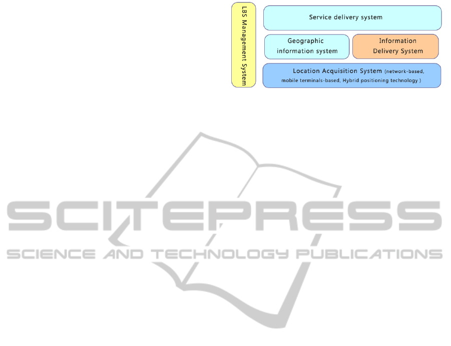
4 A NEW LBS FRAMEWORK
Until now, mangy frameworks have been released,
the paper provides a new framework, this framework
consists of the following functional components: (1)
Location Acquisition System (2) LBS Management
(3)
Information Delivery System (4) Geographic
information system (GIS) (5) Service delivery
system .Figure 1shows this framework.
Figure 1: the framework of LBS.
4.1 Location Acquisition System
It is mainly through the positioning technology to
get the exact location of mobile customers, where
location data is the basis LBS system. Positioning
technology is divided into the following three
categories (Bin and Xiaobai, 2006):
1 Network-based positioning technology
(reverse link positioning);
2 Positioning technology based on mobile
terminal (forward link positioning);
3 Multi-system hybrid positioning
technology.
Network-based Positioning Technology
In network-based positioning technology, the
main function of the location calculation is realized
by the networks. Commonly used network-based
positioning technologies are COO (Cell of Origin),
AOA (Angle of Arrival), TOA (Time of Arrival),
TDOA (Time Difference of Arrival), E-OTD
(Enhanced Observed Time Difference), AFLT
(Advanced Forward Link Trilateration). Due to
limited space, this article describes only the most
commonly used COO.
COO location technology originated in the
cellular positioning technology, through the
collection of the mobile terminal identification
number (Cell-ID) to determine the user's location, its
accuracy depends on the radius of the base station
area where the terminal in. The advantage is no need
to change the mobile terminals and networks, and is
the most economical. The disadvantage is low
accuracy, especially in CDMA base stations
covering a wide range (Xin, 2008).
Location Technology based on Mobile Terminals
Satellite positioning originated from the U.S.
military. Russia's GLONASS, Europe's Galileo and
China's Compass Satellite System are following.
The U.S. GPS was undoubtedly the most widely
used system.GPS location technology is like this:
The mobile phone needs to receive more than 4 GPS
satellite signals the same time, the satellite
navigation message demodulation, with signal delay
ICEIS 2011 - 13th International Conference on Enterprise Information Systems
540

mobile phones get pseudo-range to each satellite,
with all these information it is able to calculate the
exact location of mobile phones, and the use of
differential techniques can improve the accuracy to
20 meters level. GPS can be achieved within a
global all-weather, continuous real-time for the user
to provide accurate position, velocity and time
information. But there are som disadvantage such as
the cold start of GPS receiver takes long, positioning
consumes too much power, the poor signal in city
with skyscrapers and indoor areas can lead to poor
positioning.
Hybrid Positioning Technology
Hybrid location positioning technology is a
direction, which combines the terminal-based
positioning technology and network-based location
technology advantages, so that it is more accurate
and reliable. Qualcomm GPSONE technology which
uses its unique patented technology, is currently the
highest performance hybrid location technology
solutions. It combines wireless assisted GPS, and
advanced forward link triangulation (AFLT) achieve
high-precision, high availability and high speed
positioning. When these two kinds of positioning
technology are not available, GPSONE will
automatically switch to the Cell ID positioning
method, to ensure the success rate of localization.
The mobile station using GPSONE technology
collect measurement data at the same time from the
GPS satellites and CDMA networks (Feixiang,
2008), and then integrate the data generated by
above these two method to get three-dimensional
precise positioning. In the case where GPS satellite
signals and CDMA network signal cannot locate
separately, GPSONE system combined the two
sources of information, as long as a satellite and a
cell site is available to complete position, which
solves the traditional problems. In addition,
GPSONE system infrastructure auxiliary equipment
also provides 20dB higher than conventional GPS
positioning sensitivity, the use of hybrid positioning
GPSONE can now work deep inside buildings. In
addition, the use of GPSONE technology, the
positioning very quickly, positioning time is short,
and the power consumption of phone is mot
increased much
4.2 Information Delivery System
This refers to information delivery platform between
the mobile customers and operators, operators and
content providers. The relatively mature delivery
platform is SMS, of course, such as CDMA2000 1X,
GPRS, 3G, WAP, CSD and so on.
In addition, WIFI has become a standard in many
smart phone, and along with the construction of the
wireless city, there will be more and more WIFI
hotspots in the city. It seems that WIFI will become
a underlying technology which information
transmission system commonly uses. Compared
with SMS and 3G, CDMA2000 1X, GPRS, the
advantage of WIFI is obvious. First, the transmission
speed, WIFI rate has reached the theoretical
maximum value of 11Mbs, of course, because the
actual impact of environmental factors, the actual
rate is usual small than the theoretical value, but also
quite substantial. Second, the fees is low. SMS 3G
and so on the, its data is delivered on the
telecommunications network, while WIFI is just a
technology to access the the Internet. Compared
with the telecommunications network, WIFI cost
much little.
4.3 GIS System
Geographic information system is a system of
computer hardware and software, which is to collect,
edit, analyze, process and output, the position
information. In the LBS, GIS's main role is: 1 Path
navigation, guidance for users of the navigation
routes. 2 Information inquiry, with the use of mobile
information, to provide users with location-related
space, and weather, traffic and other value-added
services. 3 Remote tracking, monitoring, real-time
operating the vehicle. 4 Track playback, displayed
the vehicle running track according to records in the
electronic map (Wang et al., 2009).
Simply put, GIS system turns the position
information of mobile terminal into a visual position
on the map. Under normal circumstances, we can
only get three-dimensional geographic data from the
positioning system, only through GIS processed,
such data can be used for business service providers.
Getting the location information of customers, it is
equivalent to target specific customers, with only the
means to target specific customers it is able to
provide these particular customers with the
corresponding LBS services. GIS systems can be
provided by the operators, and also by business
service providers.
4.4 Service Delivery System
It is a source of service to provide business to
mobile customers. According to different market
segments, business service providers could provide
different types of customers with different services,
such as fashion youth with location-based games,
A NEW FRAMEWORK OF LOCATION-BASED SERVICES IN MOBILE INTERNET
541
chat, dating service, residential customers, business
people with mobile nanny, traffic navigation,
commercial advertising services, the industry
provide with the vehicle scheduling, emergency
rescue, logistics and distribution services.
4.5 LBS Manage System
Generally it is the operators responsible for the
operation and maintenance. The LBS management
System is the core of the location service system,
and links mobile terminals and services providing
system to enable mobile customers to obtain service
he needs from a business service provider, location-
based services such as a customer need to check
where the famous flower shop or restaurant is in the
vicinity. Or a business service provider push the
customer information according to the location
information of mobile clients, such as advertising
through location-based services system. Meanwhile,
LBS management system is also responsible for
privacy management, user authentication
management, business management and accounting
management.
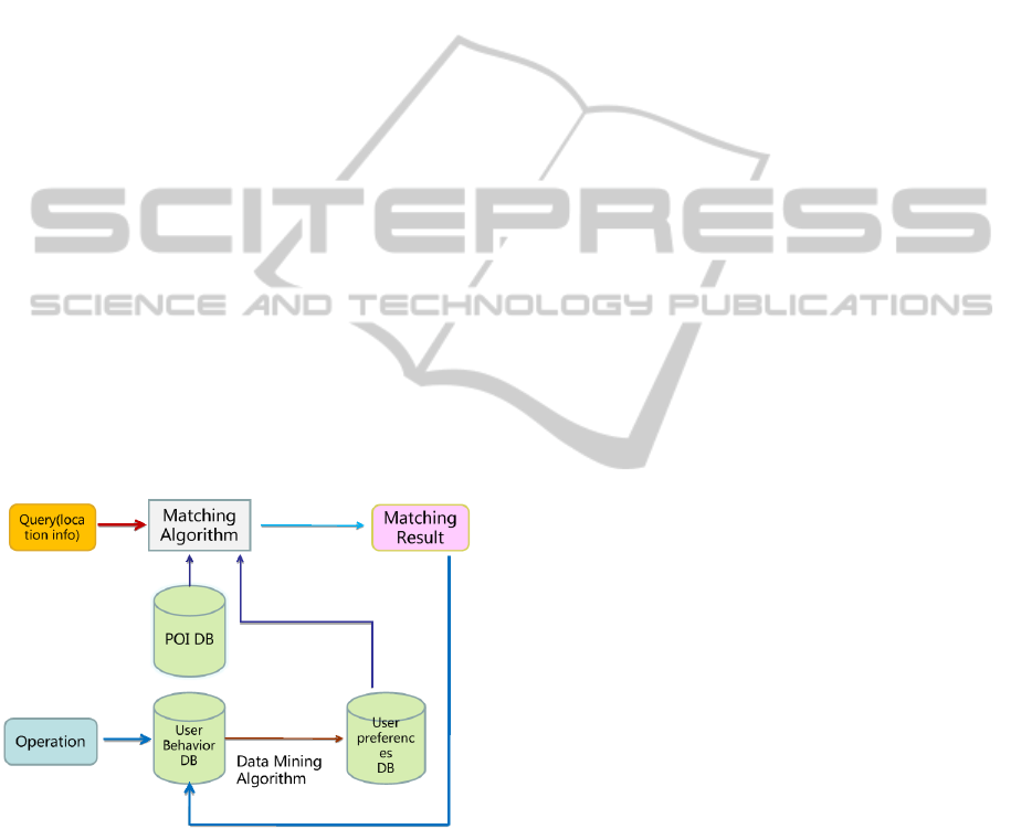
In the LBS framework, there is a important role,
which is data mining. With the system used by user,
the platform could accumulate much user behavior
information. Data mining could help improve user
experience using the information.
Figure 2: The sketch map of matching progress.
The figure above shows the sketch map of the
matching progress. When user uses this platform to
find, comment or check in somewhere, the operation
is recorded by the server. Through the data mining,
the system could find the user's preferences and
record them in the database. So next the user comes
to the application, the system could push the
appropriate item which he is interested in.
5 THE TYPICAL SERVICE OF
LBS ON THE NEW
FRAMEWORK
5.1 Personal Surrounding Map
Information
In most cases, users often do not know where they
are, especially in the strange, there is no clear
reference in the environment. In this case, it is
difficult to describe the specific location on the map
to their friends. With the personal map, your
position information could be converted to images
sent via MMS to friends. If two people are equipped
with the same mobile LBS software, they can send
the GPS location which is in the form of send text
messages to each other, the receiver could open the
messages using the same mapping software, and
then can know exactly the specific location of each
other (Yongxiang, 2009)
5.2 Individuals POI Search
Taking the size of mobile screen into account, points
of interest (POI) on the electronic map on the mobile
phone is often hierarchical display, which makes the
user find the banks, hotels, shops and bus stops and
other information from nearest location is too much
trouble. Through the individual POI search, the users
could selects from the current location to find POI
information. Individual POI search supply a form of
extended search mode, which is from one point to
the surrounding to quickly grasp the useful
information around (Chunhui et al., 2009)
5.3 Personal Location Information
Inquiries or Share
Because mobile phones with GPS could get of the
exact location of the user information, and the
private information leakage due to query of private
location information has been criticized much for
mobile phones with the function of locating.
Different from cell phone locate, GPS mobile phone
can be set that the GPS position is open or not in
order to protect personal privacy or the query or
share personal location information function which
is useful for special groups, such as the elderly,
children and other special needs which it is
necessary to know the location of the other.
ICEIS 2011 - 13th International Conference on Enterprise Information Systems
542

5.4 Road Guide
Road guide features fully use the GPS navigation.
Input or select a specific position of the starting
point A and end B then you can be informed of the
path from A to B in the from of text or images. The
text describes the path through which the road name,
such as: [Egret Park] to [the lake park] path: Lake
Road - North Hubin Road - Lake Road - Xianyue
Mountain Tunnel - Nanshan Road - Huatai Road.
Navigation picture is the images of things on the
road. Path generation algorithm includes the shortest
path, the main road first, straight preferred and other
options. Meanwhile, it integrates the road guide
track record and playback function. It is able to
record the track of travel or the process of finding
the path way real-time, which makes you able to
know the return route in a strange environment, so
that owners can enjoy themselves.
5.5 Thematic Information
The thematic information services need personalized
data and the support of info server. Personalized
data, is also known as rich points of interest (Rich
POI). A restaurant Rich POI points, for example,
compared to the usual sense of the POI data points,
in addition to containing the name of the POI,
longitude, latitude information, included address
description, area code, phone number, profile,
pictures, and even recommended signature dishes,
cuisine, taste, dining environment and the dining
experience of users and so on. Information server is
provided by the service provider, could be accessed
through wireless network for a specific POI. Current
trends in integration of mobile phones and the
Internet has become more evident, content and
services will become more dominant area. Full use
the function of network data communications of
mobile phone, coordinate the software on the mobile
terminal and information server, and provide users
with information service platform. Mobile end-users
using the same platform could easily mark
geographical information point, introduce tourist
attractions, make up stories related to geographical
position and describe the traffic situation and so on.
The info server collect information of all kinds, then
edit sort, select, identify, storage, in the end make up
some rich points of interest, and then open the
processed the information to other users.
Through the establishment of server of rich
points of interest, the thematic information services
could provide the user with:
Introduction of Tourist Attractions
Many owners of private vehicles or hobbies GPS
players enjoy MICE tourism. A lot of them hope to
plan the travel route by car, and be able to learn
more about Attractions and other information before
to go. In order to meet the needs of this part of the
user, it is necessary to rich the information of tourist
attractions :: For normal POI search, users can get
just the necessary information ,for rich POI search,
the user could get much more information.
Classified Living Information Services
The key of whether the navigation and LBS
services is popular is that whether the service
provided close to life of the user. Category searching
lives try to provide the user with lifestyle
information as much as possible. The user can
search by category to find the business, goods, rent
and other various categories of information. This
function can be got by category search, in this way it
is able to concentrate on providing similar
information to the user, allowing users to have more
choice.
Business, Corporate, Product Introduction
Services
In the POI search, each POI is probably a
specific business or enterprise. Through the POI
search, users can learn the business or enterprise
product introduction and promotion. At the same
time, the information server also supports member
companies users to add POI information or custom
POI's information, allowing various businesses and
enterprises to enrich the POI information system,
which is good for business enterprises and end users.
Weather Forecast Service
Information Server could collect weather
information for many cities, and then provide it to
the end users. In addition, some other information
related to weather can also be provided to the user.
6 CONCLUSIONS
LBS define the framework of spatial information
services and mobile location services, in the 21st
century it will play an extremely important role. This
paper presents a new framework of LBS, analysis
some of the typical business which LBS could
provide, then sums up the characteristics of LBS
business:
The development of LBS technology is not
mature at present, such as the industrial chain, is not
immature.
A NEW FRAMEWORK OF LOCATION-BASED SERVICES IN MOBILE INTERNET
543

The result of locating is in low accuracy. It is
certain that these problems can be solved in the
future a big development will be made in LBS.
ACKNOWLEDGEMENTS
This work is supported by the National Key project
of Scientific and Technical Supporting Programs of
China (Grant Nos.2008BAH24B04, 2008BAH21B
03, 2009BAH39B03); the National Natural Science
Foundation of China (Grant No.61072060); the Pro-
gram for New Century Excellent Talents in
University (No.NECET-08-0738); and the Innova-
tion Technology Star Program of Beijing (Grant
No.2007A045).
REFERENCES
Pan Kexian, Development of the location-based service
application of intelligent mobile phone, Information
Technology, Vol.10, 2000.
Song Xiaodong, Wu Mengquan, The technique and
application of the location-based services, Northeast
surveying and mapping, Vol.26 No.2 June, 2003
Wang Shuai, Liu Houquan, Cheng Shuang, The
Application and Research of LBS in Mobile Guide
System. Micro computer info, Vol.26, 2010
Jiang Bin, Yao Xiaobai. Location - based services and GIS
in perspective [j] Computers, Environment and Urban
Systems, 2006, 30: 712 - 725.
Li Xin, Research on mobile GIS application pattern based
on LBS. Science of Surveying and Mapping, Vol. 6,
2008.
Chen Feixiang. Research on mobile spatial information
services based on LBS. Computer Engineering and
Applications, Vol.13, 2008
Wang Chong Ming, Wang Ze Min, Zhu Li Zhong,
Problems and Methods in the Location-Based
Services, geomatics and spatial information
technology, Vol. 32, 2009.06.
He Yongxiang, The Application of LBS Location Service
Technology In The Field of ITS, Intelligent
Transportation System, Vol. 32, 2009
Zhou Chunhui, Zhu Xin-yan, Su Ke-hua, Qin Qian-qing;
Research on POI Query and Update Mechanism Based
on LBS, Microcomputer Information, Vol. 25, 2009
ICEIS 2011 - 13th International Conference on Enterprise Information Systems
544
