
MASC: Map Sectors Creator
A Tool to Help at the Configuration of Multi-Agents Systems for Everyone
Aurélie Gaudieux
1
, Joël Kwan
2
, Yassine Gangat
3
and Rémy Courdier
3
1
Centre d’Economie et de Management de l’Océan Indien, University of Reunion Island, Saint-Denis, Reunion Island
2
Ecole Supérieure Ingénieur Réunion Océan Indien, University of Reunion Island, Saint-Denis, Reunion Island
3
Laboratoire d’Informatique et de Mathématiques, University of Reunion Island, Saint-Denis, Reunion Island
Keywords: Automation, Initialization, Configuration, MAP, Sketches, Plans, Cutting Out, Extraction, Grid, Bitmap
File, Code Snippet, Online, Web Based, User-Friendly.
Abstract: The initialization at the beginning of all type of simulation is recurring. In the field of multi-agents, spatial
environments on a micro or macro scale, or more abstract context, such as mapping out energy sources for
example, need often to be modelled. The initialization of these environments wherein evolve agents is
generally tedious and time-consuming depending on the fineness of the mesh of the cutting in case of a 2D
spatial representation. In this paper, we present MASC (Map Sectors Creator), a user-oriented tool that
permits easy initialization through the creation of a mesh directly usable in multi-agents systems simulations
platforms. The automation of cutting out maps followed by the generation of directly usable code snippets
optimize the working time on initialization and allow to focus on the simulations results and observations.
1 INTRODUCTION
Computer modelling is the formal description of a
system that allows manipulation of a virtual copy
using a computer. To obtain this virtual
representation, a model must be implemented. The
process from a theoretical context to a more concrete
one involves the production of codes to be used to
have a final product in the form of an application.
Before running a simulation, the initialization
must be settled, which includes configuring the
simulation context. Knowing that the context has a
huge impact on the proceedings and the outcomes of
the simulation, we often give more attention to data
in particular and starting environment. Each
configuration leads, so to speak, to an almost unique
experience depending on the configuration settings
(Gangat, et al., 2009).
Optimization of working time issue arises when
handling complex systems, especially in multi-
agents systems where more attention must be paid to
data and different proceedings performed during
iterations.
To help solving this problem, we propose MASC
– Map Sectors Creator, an easy to use tool that can
provide an environment base represented by cutting
a base map, a diagram or a plan into a grid of sectors
directly usable in multi-agents simulation platforms
such as NetLogo (Wilensky, 1999) or the platform
of multi-agent simulation of IREMIA laboratory at
the University of Reunion Island, GEAMAS-NG
(GEneric Architecture for MultiAgent Simulations)
(Payet, et al., 2006).
Thus, MASC permits to save time and focus on
implementation of models. In addition, MASC
provides a simplified user experience through
opportunities brought by recent developments in
Web technologies. We want to propose a user-
friendly tool that could help anyone to optimize
working time and facilitate the configuration of the
initialization. The word “masc” means “men” in
Portuguese.
This kind of tool is useful for several simulation
domains for example geographical, economic,
meteorological or epidemic ones.
2 MASC
2.1 The Need
In the context of models based on real existing ones,
we perform simulations in which agents operate on a
836
Gaudieux A., Kwan J., Gangat Y. and Courdier R..
MASC: Map Sectors Creator - A Tool to Help at the Configuration of Multi-Agents Systems for Everyone.
DOI: 10.5220/0005133408360844
In Proceedings of the 4th International Conference on Simulation and Modeling Methodologies, Technologies and Applications (MSCCEC-2014), pages
836-844
ISBN: 978-989-758-038-3
Copyright
c
2014 SCITEPRESS (Science and Technology Publications, Lda.)
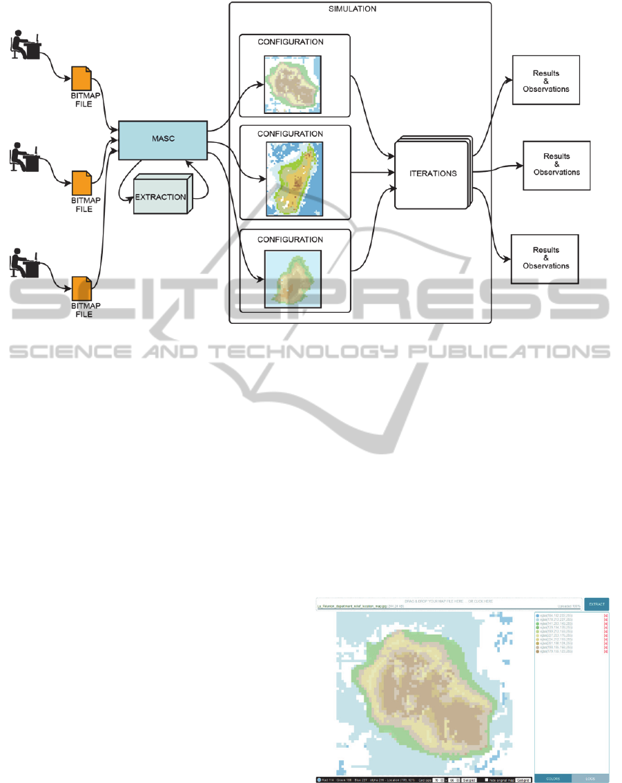
Figure 1: Using MASC for configuring multiple experimentations of a simulation.
space generated from spatial division of maps. E.g.:
SIEGMAS (Gaudieux, et al., 2014).
Some existing tools already provide some parts
of solution to this problem. We can take the example
of XELOC Language, eXtensible Editing Language
Of Configuration, which is a support for the
configuration an initialization of multi-agents
systems. XELOC is based on the basics of XML and
requires the handlings of another programing
language. One of MASC objective is to repeal both
the acquisition processes and handling of a new tool.
The development of a tool like MASC was
driven by mainly two reasons.
Firstly, the need of a tool allowing the
automation of the process of cutting out maps to
perform multiple simulations of a same model with
different geographical areas. The tool aims to
facilitate the transition from map into an exploitable
representation. It is very interesting to incorporate
modelling with different configurations. Some
models can lead to significant results from the
abstract level to a less abstract one.
And secondly, the use of a user-friendly tool also
permits to effortlessly make rather redundant tasks
of creating an environment where agent evolves
along different simulations. Several configurations
can then be produced more efficiently in no time as
revealed in Figure 1.
2.2 The Concept
MASC has been designed to increase productivity
on implementing a model so that it provides a
streamlined user experience. That is why the tool
was developed in order to ask the fewest operations
and minimum familiarization while providing
enough controls. The user interactions with MASC
interface are then based on the daily operations
being done by any computer user (drag and drop,
file uploading, form filling, mouse clicking). The
graphical user interface (Figure 2) is quite simple
and reduces the displayed information to only the
useful ones.
Figure 2: MASC GUI.
The quantity of requested information to input is
also kept to a minimum, the rest being automatically
filled by calculations.
MASC:MapSectorsCreator-ATooltoHelpattheConfigurationofMulti-AgentsSystemsforEveryone
837
A question arose as to which file types would be
supported by the tools. The most used type of output
images are vector graphic files generated from GIS
softwares or bitmap files for several maps, plans,
drawings, sketches, or other digital copies created
from paper versions. Knowing that it is much less
restrictive to convert a vector image into bitmap on
to the opposite direction, we have decided that the
first versions of the tool would only support bitmap
images in input.
Moreover, we wanted the tool be designed so
that it is usable at any time by anyone with any
computer without altering the workspace of the user.
That is why we chose to make an online web based
application.
Regardless the necessity of a connection to the
server, the downside of this type of application is
that the power of calculation is limited by the
capacity of the hosting server and the technology
used for the different calculations and the allowed
uploading file size. For the first version of our
application, we chose to make it deployable to a
maximum of easily accessible servers. So we
deployed it on a basic server provided by a common
hosting plan. And for a maximum compatibility with
available programming languages on these type of
hosting, we used PHP programming language for the
server side coupled with HTML5 and JavaScript for
the client side.
On the upside, anyone can access the application
with a simple connection to the server and a recent
Internet browser. In a future perspective, the server
side will be switched to a Java version that will have
a better performance calculations but require an
upgrade of the hosting plan.
2.3 Presentation
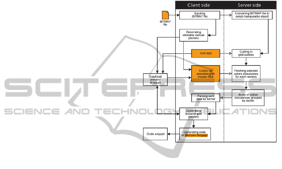
2.3.1 The Ease of using MASC
Using MASC is divided around three main steps.
The first step consists of inputting all the necessary
information needed by the tool to correctly extract a
cutting grid space from an image that is presented to
it. This stage takes place mainly on the client side
that is to say on the user’s Internet browser (shown
highlighted in Figure 3). The information required
for the proper functioning of the tool are:
A bitmap image file in JPEG, PNG, GIF, or
TIFF format, which is a representation of the
space where agents evolve during the
simulations.
The size of the grid is simply summarized by
the number of sectors to cut out across the
width of the image. Because we are working
with a grid where sectors are square shaped,
the number of sectors in the height direction
can be automatically calculated.
A list of colors selected from the preview of
the image taken by clicking on it.
Figure 3: Details of MASC workflow.
In a second time, these three data are sent to the
server. Then the script on the server can manipulate
the bitmap file and can extract a grid that will serve
as a starting point for generating the code snippet
used for initialization of simulations. At this stage,
the user will have no operations to do, all the
treatments will be done in autonomy at the server
level.
In the last step, new information resulting from
the extraction made on the server side is displayed
graphically to the user using the preview area of the
graphical user interface displayed on his browser.
On the one hand, the user has a preview and on the
other hand he can slightly edit the grid before final
code snippet generation according to the chosen
programming language. At this level, the user can
still change the color of the different sectors by
clicking on them.
If needed, the user can change the number of
given sectors across the width to change crisscross
scaling and then regenerate the code snippet.
2.3.2 Colors
Always with the idea of putting the user at the center
of the experience and increasing the productivity in
SIMULTECH2014-4thInternationalConferenceonSimulationandModelingMethodologies,Technologiesand
Applications
838
mind, MASC uses a list of colors selected from the
image by the user. This list is used in the second
step. It also allows to filter unwanted colors and to
avoid to keep annotations that are often merged on
the image itself. So the user only select interesting
colors.
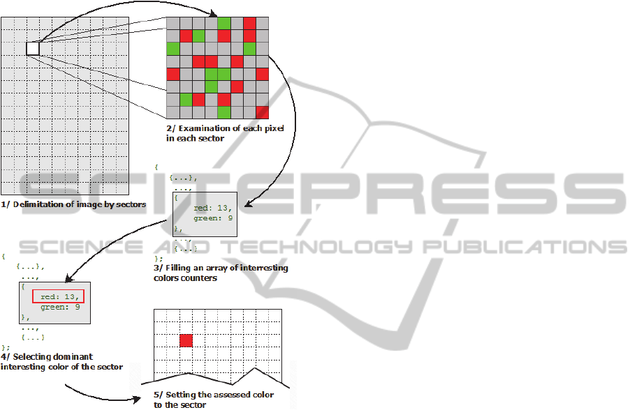
Figure 4: Colors interpolation.
When extracting the colors, the image is divided
into sectors according to the given cutting grid. Then
each pixel is examined to determine if the pixel
color matches with one of the colors in the list. If it
is the case, the counter of the matching color in the
sector of the pixel is incremented.
In this process, the tool tolerates a degree of
shade. Thus, the color alterations brought by the
image compression does not prevent MASC to
correctly extract the desired colors in each area.
An array of colors grouped by sector is gradually
created regarding the progress of the review of the
image pixels. Then, the dominant color is selected to
be the color of the sector (Figure 4). By proceeding
pixel by pixel, the precision of the interpolation that
assesses a sector color is dependent on the cutting
out grid size. The more sectors across the width is
given in input, the greater the precision will be.
There is no minimum grid resolution, it all depends
on the goal and the need of the model.
To allow a certain degree of freedom and to
leave the choice of colors to prioritize on sectors, the
user can click on the preview grid cells to choose the
dominant color regarding the listed ones in the
working sector. These modifications are stored in
the client side to avoid the useless data transfers
between client and server. So directly after the
adjustments brought by the user, the code snippet
containing the representation of the space can be
generated.
3 CASES STUDY
The team being at work on two ongoing projects.
SIEGMAS which use the simulation platform
NetLogo and EDMMAS, which use the GEAMAS-
NG, we would like to test the relevance of MASC in
these projects. In this part of the paper, we will
explain the advantage of using MASC with theses
example.
3.1 SIEGMAS
SIEGMAS (Stakeholders Interactions in
Environmental Governance by a Multi-Agent
System) is a modelling conceptualized in order to
study the deviances of the farmers against the
forester and natural resources protected by the
management's transfers or another text of law.
3.1.1 Context
In the context of this project, the economical and
classic steps being limited enough for the
conceptualization of the individuals' behaviors and
the process of the common pool resources, a process
of multi-agents systems allows some improvements
in the study of these phenomenon and the creation of
a sales tool for the decision
This modelling has been conceptualized in order
to study the deviances of the farmers against the
forester and natural resources protected by the
management's transfers or another text of law.
Therefore, this simulation allows to identify the
interactions between the actors of the governance
taking part in the management's transfers and to
propose some targeted measures in agreement being
able to reduce the merging anomalies. Thus, this
model reveals that the knowledge of the sanctions by
farmers does not prevent them to infringe the
legislative measures of protection of natural
resources coming from the management's transfers
MASC:MapSectorsCreator-ATooltoHelpattheConfigurationofMulti-AgentsSystemsforEveryone
839
or located in some few protected areas. (Brandouy,
et al., 2012).
3.1.2 SIEGMAS
Farmers (deviant or not) generally aim to make their
land as profitable as possible to cover several costs
(e.g. investment, maintenance). A farmer can choose
to spread legally his cultivation via the purchase of
new plots or reaching the legally maximum allowed
use of natural resources. In fact, the management's
transfers grant the farmer through the basis
community some right of cultivation of some natural
resources. However, the farmer can be a deviant by
farming illegally some plots of natural and forester
resources.
This model is mainly focused on the farmers and
the government and their interactions in relation to
the forester and natural resources as well as the
resources produced on the farms.
The model SIEGMAS has been implemented
under the platform of the programming called
NetLogo. The farmers can respect or infringe the
legislation towards the protection of natural
resources. The controls or the rupture can identify
the transgressions. Authorities grant some individual
sanctions to the deviants. Thus, not any collective
sanction impacts the respectful farmers of the
legislation. The farmers set themselves up in order to
increase their productivity and to perpetuate the trust
that the state authorities grant (or to avoid the
sanctions for everything by having a nearby context
in favor of their activity (Wade, 1987).
For the sanctions, the deviants want to exploit
randomly the lands being around his exploitations,
even those created illegally. At each iteration, the
government notes a random number of lands
illegally exploited and looks for the one who created
the exploitation. After launching several times the
simulation with different values of configurations, it
appears by observing the variation of the rate of
deviants that if the government controls the
management's transfers correctly, the sanctions are
well applied. The presence of the deviants increases
land deterioration. Some deviants however manage
to avoid sanctions and run some untaxed incomes.
Nevertheless, the application of a sanction to the
deviants rebalances the system so that the deviants
cannot get any profits from the illegal practice of
agriculture or the exploitation of natural resources.
Therefore, individual behaviors impact the collective
behaviors if a farmer knows the machinations of his
neighboring. The farmer generally grants his trust to
his neighbor as long as it doesn’t involve being a
deviant. However, if he knows the acts of deviance
of his neighbor, he will be more suspicious against
him and will denounce him.
This modelling is quite difficult to implement
and require a lot attention. For testing the model,
several configurations will be applied to multiple
simulations. Usually, these tasks take a lot of time to
prepare. Not to waste time, the creation of these
initial states should be automated.
3.1.3 MASC with SIEGMAS
In this case study, we are trying to model the
interactions between stakeholders in a precise
geographical area. To do so we have to create a
representation of a region in a simulation platform.
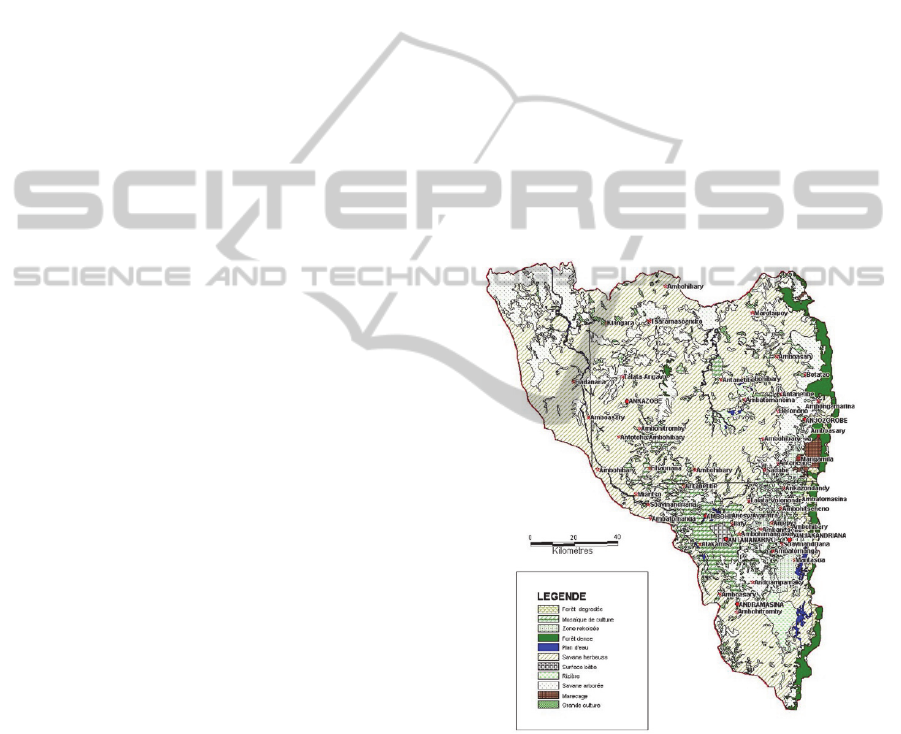
In this specific example, the region of Analamanga
(Madagascar) which directly usable map data are
quite difficult to find, is used. So we go from a map
extracted from a digital document that was provided
to us (Figure 5).
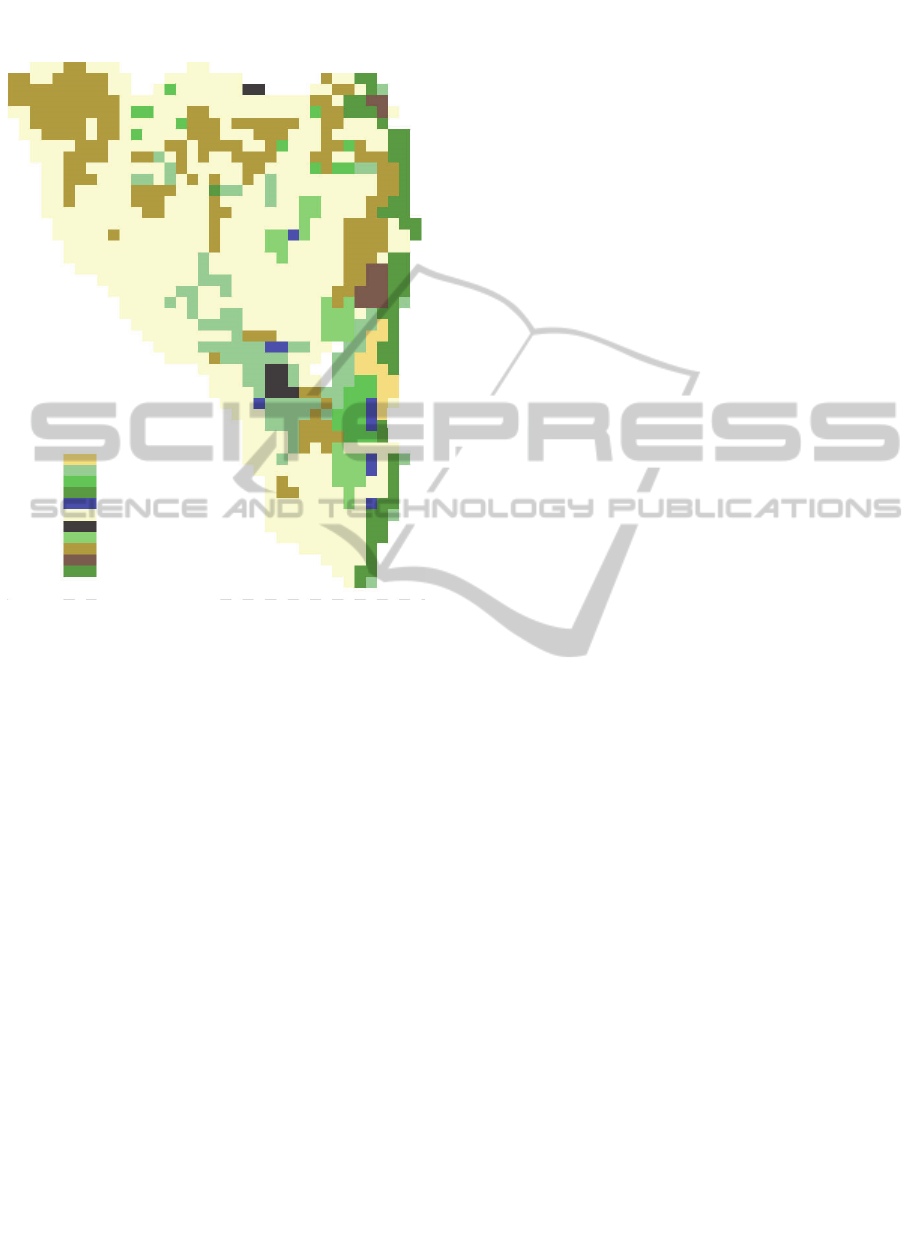
Figure 5: Analamanga region map.
Without MASC, we would have been constraint
to crisscross the image in software image processing
and then to manually select and assess the color of
each sector of the grid. Thanks to MASC, these tasks
were simply handled by giving the image file, the
number of sectors to cut in the width direction and a
color swatches that we simply took from the legend
of the map by clicking on it. Afterwards, a preview
was displayed to us (Figure 6). We decided then to
prioritize the colors of the sectors or not and
SIMULTECH2014-4thInternationalConferenceonSimulationandModelingMethodologies,Technologiesand
Applications
840
generate the code snippet regarding the chosen
programming language, in this case NetLogo.
Figure 6: Preview of Analamanga region map generated
by MASC.
Part of generated code snippet for Analamanga
region map:
; Permits to create a representation of
the map
to create-world
clear-all
set-patch-size 20
resize-world 0 39 0 50
ask patch 0 50 [
set pcolor [186 158 74
]
ask patch 1 50 [
set pcolor [186 158 74]
]
ask patch 2 50 [
set pcolor [255 252 217]
]
ask patch 3 50 [
set pcolor [255 252 217]
]
[...]
ask patch 36 0 [
set pcolor [255 255 255]
]
ask patch 37 0 [
set pcolor [255 255 255]
]
ask patch 38 0 [
set pcolor [255 255 255]
]
ask patch 39 0 [
set pcolor [255 255 255]
]
end
The advantage of using MASC in this context
was to more or less finely crisscross the map to
translate from the bitmap file to an exploitable
representation of this map inside a simulation
platform. As a result we can have easily different
grid resolutions of the map with no effort and can
deploy rapidly different base maps for different
configurations.
This methodology also allows model
transposition to different geographical regions, for
different simulations executions on Reunion Island
and Mauritius regions and comparing obtained
results.
3.2 EDMMAS
EDMMAS (Energy Demand Management by Multi-
Agent Simulation) is a prototype based on the model
of the same name for simulating the production and
consummation of energy according to the evolution
of the population over the years.
3.2.1 Context
The issue in the EDMASS project is the energy
development of a territory using a reproducible
modelling. Reunion Island provides a favorable
research field in this area thanks to its isolations
because its small area (2.500 km²) promotes the
quest of new forms of energy development and
prohibits electricity production from nuclear power.
EDMMAS is a tool for helping experts to make
decisions through ABS, an overview of the
evolution of electricity consumption by 2030 and to
provide new facilities.
3.2.2 EDMMAS
EDMMAS is and evolution of DS model used to
explore various scenarios of land usages and
conservation planning that simulates on the whole
island, the interactions between the three types of
land use (natural, agricultural and urban), in order to
allow observation of the changes induced. The
energy layer has been added to allow this (Figure 7).
MASC:MapSectorsCreator-ATooltoHelpattheConfigurationofMulti-AgentsSystemsforEveryone
841
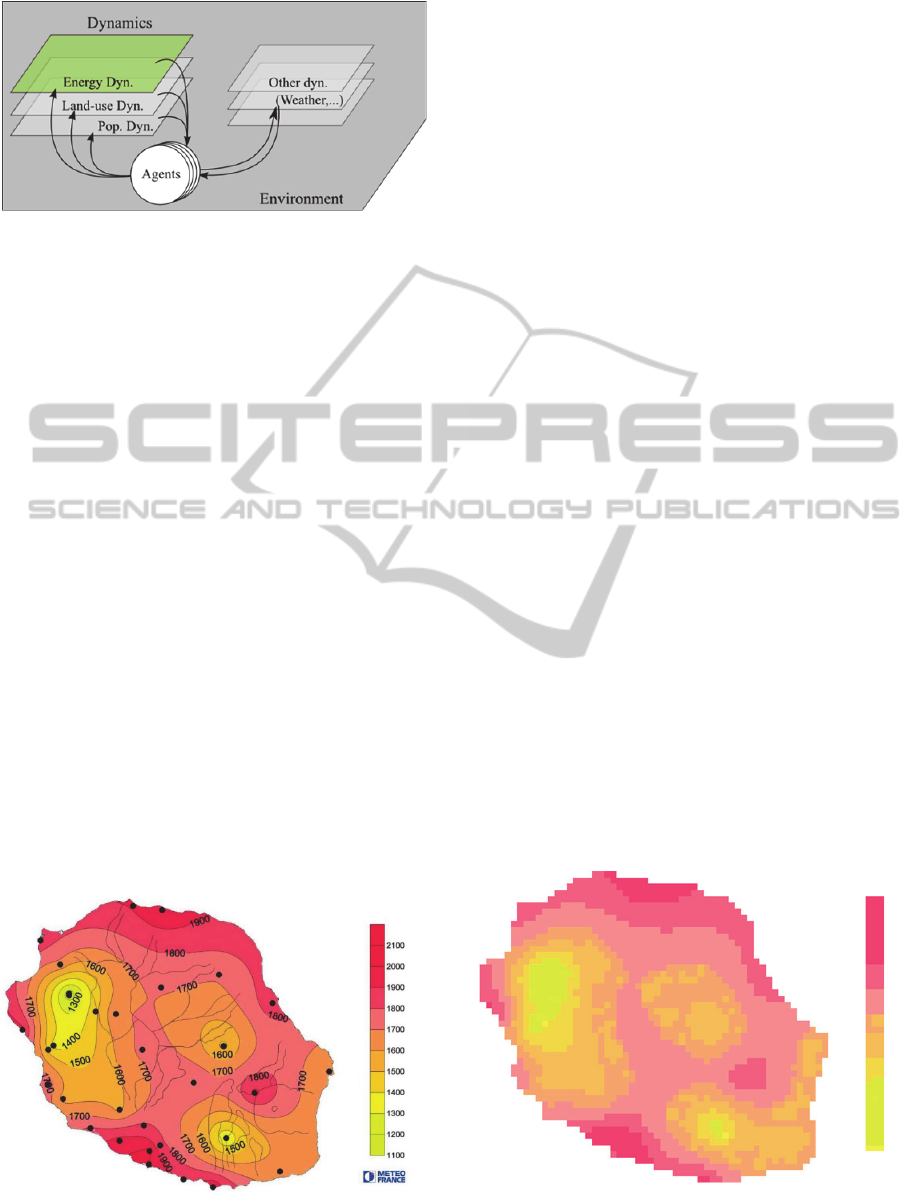
Figure 7: EDMMAS dynamics.
EDMMAS was designed on the GEAMAS-NG
simulation platform. This platform has been created
with several powerful tools to reduce the gap that
lies between the real and complex system model.
Among the innovations of this platform, we notice in
particular XELOC. XELOC is a support for
configuration and initialization of multi-agent
systems. It is established on the basis of XML,
enriched by a semantic script language. Thus, while
a configuration for defining the form of a
conventional XML description, XELOC offers the
possibility of synthesizing a complex configuration
by means of a dynamic process. In addition, XELOC
incorporates a rich initialization technique using
semantic maps provided by mathematicians. All this
makes XELOC, scalable and accessible by nature, a
generic support used in many contexts of
implementation. A XELOC interpreter has been
developed within the GEAMAS-NG platform.
3.2.3 MASC with EDMMAS
In EDMMAS, we handle maps containing
information on energy sources available in Reunion
Island. We tried to use MASC to complement
XELOC Language and facilitate simulation
initialization.
Figure 8: Reunion Island average annual global radiation
(2009).
We take a map of average annual global
radiation to the horizontal of Reunion Island in 2009
(Figure 8) for the practical case.
Using MASC, we can easily retrieve a XELOC
code snippet corresponding to the map with the
correct color codes without using multiple tools.
When we manipulate codes, we usually don’t want
to lose time with redundant tasks such as picking all
wanted color codes in an image. Thus we benefit of
using advantages of MASC and XELOC Language.
MASC allows color selection and generates
effortlessly code snippets in XELOC language.
Part of generated XELOC code snippet of the
example:
<forMap name="OurMapName"
url="./myMapFile.jpg"
resolution="16">
<legend name="3classes">
<label name="rgba(255,18,56)"
r="255" g="18" b="56" />
[...]
<label name="rgba(229,255,0)"
r="229" g="255" b="0" />
</legend>
<cell legend="10classes"
operator="average"
mode="closer">
<case label="level_0">
<!-- INSTRUCTION FOR #0 -->
</case>
[...]
<case label="level_9">
<!-- INSTRUCTION FOR #9 -->
</case>
</cell>
</forMap>
Figure 9: Preview generated by MASC of the average
annual global radiation of Reunion Island.
SIMULTECH2014-4thInternationalConferenceonSimulationandModelingMethodologies,Technologiesand
Applications
842
Using MASC for generating XELOC code
snippets does not require to send the image on server
for a post treatment. In this case, MASC is just an
advanced color picker which allows to generate
XELOC code snippet as output. We also note that if
we need the reuse of this map for NetLogo, we have
just to set the grid resolution, ask for extraction, and
then change the language choice and regenerate the
code snippet that enables us to have an equivalent
map in patches for NetLogo (Figure 9).
Part of generated NetLogo code snippet for
Reunion Island average annual radiation (2009):
;Permits to create a representation of
the map
to create-world
clear-all
set-patch-size 20
resize-world 0 59 0 44
[...]
ask patch 19 44 [
set pcolor [254 91 117]
]
ask patch 20 44 [
set pcolor [254 91 117]
]
ask patch 21 44 [
set pcolor [254 122 135]
]
[...]
ask patch 59 0 [
set pcolor [255 255 255]
]
end
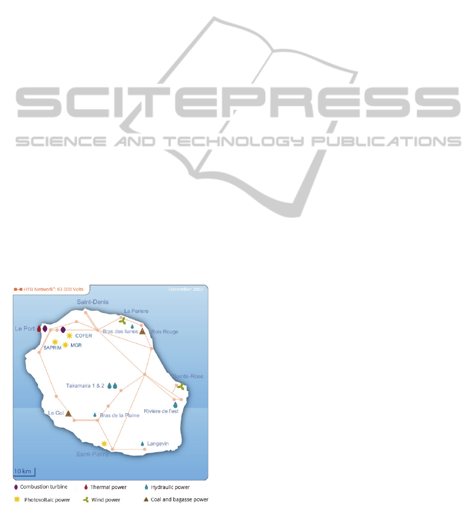
Figure 10: Reunion Island power plants (2007).
We notice in this example of type of use that an
advanced version of MASC would be very useful if
the tool can also permit to set the location of some
agents on the map. In the context of EDMMAS, we
can take for example the localization of power plants
in Reunion Island (Figure 10) that will be the agents
of the model. Keeping in mind that MASC is
designed to facilitate the configuration of
simulations, one of the future goals of MASC is to
allow the placement of agents in addition of creating
the environment in which they evolve.
4 FUTURE WORKS
MASC is already a fully functional tool and
responds more or less to the initial requirements
mentioned in above parts of this paper. However,
during our experiencing phases, we note that the tool
can be improved to improve its effectiveness.
On the server side, an upgrade of the hosting
plan would permit a usage of another programming
language for example Java which allows to have a
compiled server side application to improve the
calculation time instead of an interpreted script.
With Java, we could also ignore the passage of data
through Apache server and prevent the flow of
information between several services. The client side
will directly communicate with the server side of the
application.
The client side can also be optimized by
modifying some functions and not using frameworks
as it is now. The advantage of using frameworks is
the time gained at developing the tools. Once the
proof of concept is acquired, the next step of MASC
is optimizations.
Then we can also add more feature on this tool.
Actually, the tools only manipulate the space of the
simulations. It could also permit to prepare the
initialization of multi-agents such as the positioning,
setting up clusters of patches or boundaries. We
could also expand the list of available multi-agents
simulation platform languages to generalize the use
of the tool and permit more members of the
community of the domain of multi-agent systems to
use it.
5 PERSPECTIVES AND
CONCLUSIONS
The redundant problem of creating representation of
a space in multi-agents systems leads us to find
MASC:MapSectorsCreator-ATooltoHelpattheConfigurationofMulti-AgentsSystemsforEveryone
843

some useful tools to be more productive. We often
use maps from GIS softwares, paper supports and
other electronic documents that we want to set up in
our simulations.
In this article, we presented MASC, a support
tool for configuring multi-agent systems based on
the information extracted from colors of bitmap
images. MASC aims to provide a simplified user-
friendly service for the acquisition of code snippets
ready to use with multi-agent systems simulations
platforms. Thereby, creating multiple configurations
for a same modelling can be done quickly and
easily, while allowing the users to focus on the data
and the results of simulations. Moreover, MASC
allows to effortlessly create several of more or less
finely crisscrossed map for observing the evolution
of agents on different scales and precisions. We
could gain more time on configuration if the tool
permits also the placement of the agents if needed.
Our purpose in this article was not to bring out
the possibility to automate part of the
implementation of a modelling, but rather to
highlight the lack of user-friendly tools to simplify
the initialization of a simulation, which we assessed
in example and present to community a more or less
adequate solution.
REFERENCES
Brandouy, O., Mathieu, P. and Venryzhenko, I., 2012.
Optimal Portfolio Diversification ? A multi-agent
ecological competition analysis. PPAMS (Special
Sessions), pp. 323-331.
David, D., Payet, D., Courdier, R. and Gangat, Y., 2009.
XELOC : un support générique pour la configuration
et l’initialisation de systèmes multi-agents. Journées
Francophones Systèmes MultiAgents, JFSMA’09.
Gangat, Y., 2013. Architecture Agent pour la modélisation
et simulation de systèmes complexes multidynamiques
: Une approche multicomportementale basée sur le
pattern "Agent MVC", Saint-Denis: s.n.
Gangat, Y., Courdier, R. and Payet, D., 2009.
Démonstration : Aménagement énergétique d’un
territoire - une approche par simulation multi-agents.
Journées Francophones Systèmes Multi-Agents
(JFSMA), p. 237–240.
Gaudieux, A., Gangat, Y., Kwan, J. and Courdier, R.,
2014. Multi-agents model for the study of interactions
between the stakeholders in the common pool
resources : application to the district of Miarinarivo (
Madagascar).
Payet, D., Courdier, R., Sebastien, N. and
Ralambondrainy, T., 2006. Environment as support for
simplification, reuse and integration of processes in
spatial. MAS. IEEE International Conference on
Information Reuse Integration, p. 127–131.
Wade, R., 1987. The management of common property
resources : collective action as an alternative to
privatisation or state régulation. Cambridge Journal of
Economics, Volume 11, pp. 95-106.
Wilensky, U., 1999. NetLogo. Center for Connected
Learning and Computer-Based Modeling.
Northwestern University, Evanston, IL.
APPENDIX
A version of MASC is in public access at
http://labs.jkwan.com/masc/.
SIMULTECH2014-4thInternationalConferenceonSimulationandModelingMethodologies,Technologiesand
Applications
844
