A Multi-level Ontological Approach for Change Monitoring in Remotely
Sensed Imagery
Fethi Ghazouani
1
, Wassim Messaoudi
1
and Imed Riadh Farah
1,2
1
RIADI Laboratory National School of Computer Science University of Manouba, Tunisia
2
I.T.I Departement, Telecom Bretagne Technop
ˆ
ole Brest Iroise, CS 83818, Brest, France
Keywords:
Spatio-temporal Object, Dynamics Object, Change Detection, Domain Ontology, Upper Ontology, Multi-
level.
Abstract:
Land-use/cover change, climate change, sea level evolution are examples of application that are associated
with change detection. Actually, we use satellite image time series to monitor the change where entities are
often dynamic along time. Moreover, knowledge associated to these spatio-temporal objects can evolve when
changes occur. Thus, for modeling this kind of knowledge it is necessary to deal with four aspects: spectral,
spatial, temporal and semantic. Such approach can be modeled by ontologies in many levels. Thereby, a
shared ontology can be an ontology or a combination of some ontologies based on some mechanisms of
linking. Such link process should maintain consistency between represented knowledge. In this paper, we
propose a multi-level ontological approach for monitoring dynamics in remote sensing images. The proposed
methodology aims to link our domain ontology to an upper level ontology thus enabling to represent existing
change processes.
1 INTRODUCTION
Change detection is one of the main applications of
remote sensing community. Singh (Singh, 1989) de-
fined change detection as the process of identifying
differences in the state of an object or phenomenon by
observing it at different times. The remotely sensed
data become a major source for change detection and
monitoring studies because of its high temporal fre-
quency, digital format suitable for computation, syn-
optic view, and wider selection of spatial and spectral
resolutions (Hussain et al., 2013). Geographic objects
in these data images are often dynamic. Indeed, ob-
jects with spatial representation might grow, shrink
(the case of the urban space), change their shape (for
example when a city changes its borders), divide (in
the case when a forest is divided into urban zone and
forest), disappear (a lake can disappear) or merge into
a new object (sub-parcels are merged into one parcel)
in time. Knowledge associated to spatio-temporal ob-
ject can evolve when changes occur on thematic at-
tributes of objects. The semantic dimension of an en-
tity aims to describe the knowledge associated with
the entity. Adding semantic capabilities to GIS tools
is one of solution that allows handling the semantics
of the spatial-temporal objects. However, this solu-
tion does not offer the capacity to perform inference
or reasoning on information from spatio-temporal dy-
namic phenomena (Harbelot et al., 2013).
Thus, a better framework must be able to repre-
sent the description of the knowledge in an enhanced
way that can be used to perform reasoning on dy-
namic phenomena. Such approach is offered by on-
tologies. Ontology allows a formal representation of
knowledge as well as on the reasoning on this knowl-
edge. This paper is organized as follows. In Sec-
tion 2, we start by introduce the basic principle of
ontology as a knowledge representation technology
and presents the different types of ontologies, then we
present a state of the art of different existed ontology-
based approaches for modeling dynamics of objects
and finally, we describe the dynamics in remote sens-
ing. In Section 3, illustrate the proposed approach for
modeling change in remote sensing images. Finally,
we present our conclusions in Section 4.
2 MODELING DYNAMICS
2.1 Ontology
Recently, ontology is considered as one of the better
Ghazouani, F., Messaoudi, W. and Farah, I..
A Multi-level Ontological Approach for Change Monitoring in Remotely Sensed Imagery.
In Proceedings of the 7th International Joint Conference on Knowledge Discovery, Knowledge Engineering and Knowledge Management (IC3K 2015) - Volume 2: KEOD, pages 435-440
ISBN: 978-989-758-158-8
Copyright
c
2015 by SCITEPRESS – Science and Technology Publications, Lda. All rights reserved
435
techniques used for the interpretation of images. Gru-
ber (Gruber, 1995) defines ontology as a formal spec-
ification of a shared conceptualization. Ontologies
specify a set of concepts, instances, relationships, and
axioms that are relevant for modeling a domain of
study (Gruber, 1995) and permit the inference of im-
plicit knowledge. Nevertheless, ontologies can be
very different both in terms of their ”top-level” as at
the level of the treatment of their basic components
such things, process, relationships, etc. Thus, ontolo-
gies can be classified according to two dimensions:
level of detail and degree of dependence relative to a
particular task or a point of view. Precisely, (Guarino,
1998) classifies ontologies according to their general-
ity levels. At the top level, upper ontologies describe
general concepts or sense knowledge such as space,
time, materiel, objects, events, actions, etc., which are
independent to a defined problem or to a particular
application domain. These ontologies provide gen-
eral concepts to which all terms of existing ontologies
must be linked. Domain ontologies are specialized for
a certain type of artifact. They describe the vocabu-
lary related to a generic domain (such as medicine or
automobiles) by specializing the concepts presented
in high level ontologies. Task ontologies describe vo-
cabulary related to a task or a generic activity (such
as diagnosis or sale). These ontologies provide a sys-
tematic lexicon of terms used to solve the problems
associated with particular tasks (dependent or not to
the domain).
2.2 Modeling Dynamics with Upper
Ontologies
Spatial-temporal representations are offered, by so-
called upper ontologies (foundation ontologies), such
as DOLCE (Masolo et al., 2003), BFO (Grenon and
Smith, 2004), GFO (Herre, 2010) and others. Founda-
tion ontologies provide a meta-language (Mizoguchi
et al., 1995) to ontological approach which allows to
model spatio-temporal phenomena.
In these ontologies, there exists a fundamental
distinction between static entities (continuants or en-
durants) and dynamic entities (occurrents or perdu-
rants). Endurants are objects which persist over time.
They include physical objects, for example: tree, lake,
and river. Perdurants are objects which are ”happen-
ing” at the time. They include events or processes,
but some systems, like BFO, extend the list by adding
temporal and spatio-temporal regions.
Probst (Probst, 2006) have presented an ontologi-
cal analysis of observations and measurements for as-
sessing semantic interoperability between geospatial
information sources. This approach consists to align
the observations and measurements domain ontology
to the foundation ontology DOLCE. The alignment
is performed by the interpretations of the central ele-
ments of the observations and measurements concep-
tual model in the DOLCE context and establishes ex-
plicit relations between categories of real world enti-
ties and classes of information objects. For example,
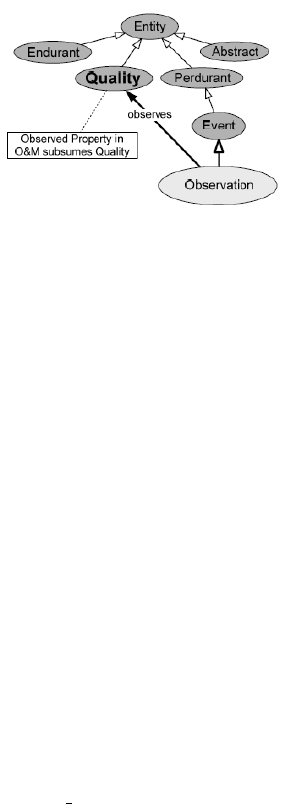
a phenomenon is described by an observed property
in the the observations and measurements specifica-
tion. In DOLCE, only qualities are entities that can be
observed. In this case, the category Observed Prop-
erty in the observations and measurements model sub-
sumes the category Quality in DOLCE (Figure 1).
Figure 1: Aligning the domain concept observation to the
concept quality of DOLCE (Probst, 2006).
In the medical domain, Camara (Camara et al.,
2012) has proposed an ontological approach for mon-
itoring and preventing the propagation of infectious
diseases. The conceptual framework adopted for
building the propagation ontology of infectious dis-
eases is structured in three layers: (i) foundation layer
which contains the upper ontology BFO, (ii) the core
layer that constitutes the IDO-core ontology where
IDO (Infectious Domain ontology) is a domain on-
tology, and (iii) the specific layer contains the sub-
domains ontologies. To align those three layers, au-
thors start by a categorization of the domain entities
as continuants or occurrents. Then, based on the IDO-
core ontology, they have linked categorized concepts
to their equivalent or parent concepts on the IDO-core
which are in turns connected to BFO. In the same do-
main, Weichert (Weichert et al., 2013) has introduced
a temporal domain ontology for biomedical simula-
tions. Aligning the domain ontology to BFO allows
to monitor the dynamics of blood flow simulations.
The correlating categories from both ontologies (BFO
and domain ontology) are identified and connected by
newly inserted is a relations.
To facilitate mutual understanding between re-
searchers, managers and local communities, Duce
(Duce, 2009) has proposed an informal ontology for
reef islands. Such ontology allows to aid the appli-
cation of information technologies to the forecasting
and monitoring of climate-change-related to impact in
KEOD 2015 - 7th International Conference on Knowledge Engineering and Ontology Development
436
reef islands environments. Indeed, the author has de-
veloped a small, prototypical reef island domain on-
tology, based on informal, natural language relations,
for 20 fundamental terms within the domain. Then,
in order to create a coherent, systematic and complete
ontology, the domain ontology have been aligned to
DOLCE as a top level ontology. To align domain on-
tology to upper ontology, the author has selected a
subset of particulars from the reef island domain in
accordance with classes categories of the upper-level
DOLCE ontology.
In a similar way, Devaraju (Devaraju and Kuhn,
2010) propose a process-based ontology for repre-
senting dynamic geospatial phenomena. The pro-
posed approach aims to improve water planning
and management through continuous monitoring and
forecasting of river flow. This approach allows to use
DOLCE top-level ontology to ease and guide the rep-
resentation of foundational entities needed to repre-
sent dynamic phenomena. Authors have aligned the
domain concepts describing precipitation and evap-
otranspiration (evaporation and transpiration) pro-
cesses to the general categories defined in DOLCE.
Thus, the entities will be identified and assigned to
perdurant, endurant and quality notions in the top-
level ontology.
An interesting work that shows the effectiveness
of the upper ontologies, in the remote sensing domain,
has been performed by Kauppinen and de Espindola
(Kauppinen and de Espindola, 2011). In their work,
they are interested in giving an ontological foundation
to essential land change trajectories, and to modeling
them with formal semantics. To achieve this they pro-
pose the Process-oriented Land Use and Tenure On-
tology (PLUTO), built as an alignment to the top-level
ontology DOLCE, for semantically integrating sev-
eral data sets related to deforestation and land change
trajectory in the Brazilian Amazon.
2.3 Dynamics in Remotely Sensed
Images
Geographic objects such as lakes, rivers, and storm
fronts have very spatial dynamic properties. It is pos-
sible that an object changes their attributes and spatial
representation along time. This observation is partic-
ularly true on the case of the remote sensing because
major applications are associated with change detec-
tion such as land-use or land-cover change. Land-
cover refers to the observed biotic and abiotic assem-
blage of the earth’s surface and immediate subsur-
face (Meyer and Turner, 1992). Examples of ma-
jor land-cover types are forests, shrublands, grass-
lands, croplands, barren lands, ice and snow, urban
areas, and water bodies. Such information is ob-
tained from ground surveys or through remote sens-
ing. Land-cover change can be characterized as land-
cover conversion and modification processes. Land-
cover conversion is a change from one land-cover
category to another, and modification is a change in
condition within a land cover category (Meyer and
Turner, 1994), i.e., the more subtle changes that af-
fect the character of the land cover without changing
its global classification. An example of the former is
change from cropland to urban land, and an example
of the latter is degradation of forests. Forest degrada-
tion may be due to change in phenology, biomass, for-
est density, canopy closure, insect infestation, flood-
ing, and storm damage.
Remotely sensed images provide measurement
and observation that can be used for monitoring dy-
namics change. Indeed, indices derived from satel-
lite data are widely used for land-cover change stud-
ies. NDVI (Normalized Difference Vegetation index)
values strongly correlate with green vegetation, and
changes in NDVI indicate changes in biological activ-
ities (Verbesselt et al., 2010). NDVI decreases signif-
icantly after green biomass is removed, so it is widely
used for mapping and monitoring fire disturbance,
forest clear-cut activity, urbanization, and other land-
cover changes (Verbesselt et al., 2010). The EVI (en-
hanced vegetation index) has been used for postfire
forest regeneration and phenological analysis during
change detection (Liang et al., 2011). Normalized
Difference Fraction Index (NDFI) (Jr. et al., 2005) is
a new spectral index for enhanced detection of forest
canopy damage caused by selective logging and forest
fires. High NDFI values indicate the presence of in-
tact forest, whereas a degraded forest is obtained by a
decreased value of this indice. Other spectral indices
are also used for detecting changes in remotley sensed
images, for more we can refer to (Chandra, 2012).
Thus, it is necessary to model this information in
order to monitor and detect the type of change pre-
sented in satellite images. In following section, we
present the adopted architecture for modeling dynam-
ics objects of remotely sensed images.
3 THE MULTI-LEVEL
ONTOLOGICAL APPROACH
As we have mentioned above, change detection is the
process of identifying differences in the state of a fea-
ture or phenomenon by observing it at different times.
In remote sensing it is useful in land use/land cover
change analysis such as monitoring deforestation or
vegetation phenology.
A Multi-level Ontological Approach for Change Monitoring in Remotely Sensed Imagery
437
Thus, we propose to represent and model the
change process in remote sensing images while bas-
ing on the cited works that adopt multi-level onto-
logical architecture for modeling the dynamics. The
conceptual framework of our suitable multi-level on-
tological architecture, as we illustrate in Figure 2, is
structured on three layers: (1) Fundamental-layer, (2)
Core-layer and (3) Domain-layer. These layers are
described on following.
Figure 2: Multi-level ontological approach.
3.1 The Fundamental Layer
The fundamental layer contains the upper ontology
that we have used in our model. We have chosen
the fundamental ontology BFO (Basic Fundamental
Ontology) as a suitable upper ontology that provides
concepts and relations that may be reused for the con-
struction or for the enrichment of domain ontology.
Consequently, we have reused these abstract concepts
and relations for modeling the ontology of change
processes (core-layer). The choice of the BFO is
based on three criteria: (i) BFO extends the list of
occurrents (event or process) by temporal and spatio-
temporal regions, (ii) the coherence of the categoriza-
tion of the concepts of process, event, state and object
towards their semantic in the domain of remote sens-
ing, and (iii) the consistency of the reuse of relations
between these concepts to cover the specific relations
in our domain.
3.2 The Core Layer
The core ontology models general concepts and re-
lations related to change processes in remote sensing
images. The definitions and the classification of these
concepts are based on the categorical classes defined
in the BFO ontology. In the following, we present the
different steps for the construction of the core ontol-
ogy of change processes.
• Identify and Categorize Changes Processes:
This step consists for understanding and detecting
modifications process in addition to conversions. In-
deed, as we have mentioned in Section 3.2, there are
generally distinctions between land cover conversion
process, namely the complete replacement of a type
of cover by another and the land cover modification
process i.e., the more subtle changes that affect the
character of the land cover without changing its global
classification. Deforestation, urbanization and deser-
tification are examples of land cover/land use change
processes.
Deforestation is the conversion of forested areas
to non-forest land use such as arable land, urban use,
logged area or wasteland. According to FAO (Food
and Agriculture Organization), deforestation is the
conversion of forest to another land use or the long-
term reduction of tree canopy cover below the 10%
threshold. Desertification is a specific expression of
land degradation processes. The degradation is a pro-
cess leading to a ”temporary or permanent deterio-
ration in the density or structure of vegetation cover
or its species composition” (Grainger, 1993). In this
case, changes affect soil characteristics, then we con-
sider desertification as a modification process.
So, in this step we have categorized the changes
as conversion and modification processes and, then
each example of change is classified to one of these
categories. In Figure 3, we illustrate an example of a
change process classification.
Figure 3: Process categorization and classification.
• Categorize Domain Entities:
This step aims to identify and classify domain entities
that participate in such change process, i.e., to know
what are the main ecological and socio-economic
variables which drive the land-cover change process.
In other words, what are the basic features required
for modeling dynamic phenomena and how they are
classified? Indeed, entities can be biophysical ob-
jects, features such as biomass, state of vegetation,
soil moisture, fire, etc. These entities will be classi-
fied into two categories of concepts: Continuants (En-
durants) and Occurrents (Perdurants). Continuants
KEOD 2015 - 7th International Conference on Knowledge Engineering and Ontology Development
438
correspond to entities without temporal part. They
include physical objects that persist in time such as
tree, lake, river, etc. The concepts of occurrents cor-
respond to entities taking place in the time during dif-
ferent phases. They are objects that occur in time and
they include events (such as fire) and processes (cut-
ting down trees) that involve the continuants.
• Identify Categorical Relations:
This step consists to know what are the categorization
relations that hold between concepts (continuants and
occurents). Examples of these relations are :
Participation: A continuant participates in a oc-
current (Grenon and Smith, 2004). A fire participates
in a deforestation.
Parthood: It reflects the notion of relationship
”part-of” and it applies to both continuants and oc-
currents. For example, an event is constituted of pro-
cesses.
The Hierarchy: It models the inheritance relation-
ships. As example, a desertification is a modification
process.
The Causality: It expresses, for example, the fact
that an event ”causes” another event. Less soil mois-
ture causes a less soil canopy.
3.3 The Domain Layer
The domain layer contains the domain ontology of
remote sensing images (Messaoudi et al., 2014) that
represents the domain concepts and their relations.
This ontology allows interpretation and representa-
tion of objects existing in the scene of satellite im-
age. The remote sensing provides observation and
measurement of indicators associated to these objects.
Indicators such as NDVI, NDFI, and derived vari-
ables (entities) of surface composition (soil moisture,
biomass, etc.) are relevant information for detecting
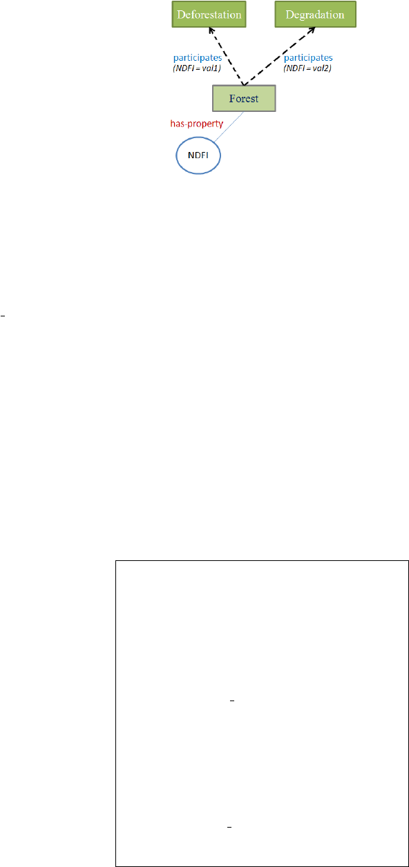
participated concepts to each change process. Figure
4 presents an example of the association of the do-
main concept forest to each of both change processes
(deforestation or degradation) in function of the mea-
sure of its indicator NDFI. In this example, the prop-
erty NDFI of the concept forest indicates that there is
a deforestation process with an NDFI value val1, al-
though it is a degradation process with an NDFI value
val2.
3.4 Alignment of the Three Ontological
Layers
As we have presented in Figure 2, the proposed model
is structured in three layers. The fundamental-layer
contains the upper ontology BFO, the core-layer de-
scribes the core ontology of change processes and the
Figure 4: Association of participants entities.
domain-layer that contains the domain ontology of re-
mote sensing images. It is necessary to link those lay-
ers for representing changes processes in satellite im-
ages. Thus, to align these three layers, we have fol-
lowed the same principle of alignment proposed in the
previously cited works. Indeed, the alignment mecha-
nism consists to identify relations R that can hold be-
tween different concepts C in the three levels. Given
the following formalization of our model, we adopt
the procedure described below for linking the three
levels.
Model =
O
f
, O
c
, O
d
, C, R
; where:
• O
f
, O
c
and O
d
represent respectively the funda-
mental, the core and the domain ontology.
• C =
C
f
, C
c
, C
d
; where C
f
,C
c
, C
d
represent re-
spectively a set of fundamental, core and domain
concepts.
• R =
{
subsumption, inherence, parthood,
participation
}
(the set of relations) (cf. subsec-
tion 3.2)
procedure alignment(O
f
, O
c
, O
d
)
// alignment of O
c
and O
d
for each change process in O
c
{
participants (C
d
, C
c
)
// the set of participants concepts (do-
main concepts) that participates on the definition of
a process (core concept) C
d
in the C
c
hold relation (C
d
, C
c
, R ) // Iden-
tify type of relationship between concepts (causes,
equivalent, participate, etc)
// create the relation link
}
// alignment of O
c
and O
f
for each C
c
in O
c
{
hold relation (C
c
, C
f
, R )
// create the relation link
}
A Multi-level Ontological Approach for Change Monitoring in Remotely Sensed Imagery
439

An example that illustrates the mechanism of
alignment has been presented in Figure 2 and Figure
3. Indeed, the Figure 3 shows the alignment of the
domain layer to core layer. In this figure, the domain
concept forest participates in the change process de-
forestation (respectively degradation). Then, the con-
cept forest is linked to the concept deforestation with
the relationship participates. Figure 2 shows how the
core layer is linked to the fundamental layer. Indeed,
concepts like conversion and modification have been
classified as two types of processes based on the cate-
gorical classes defined in the BFO ontology (cf. sub-
section 3.2). Thus, the basic concept process in BFO
subsumes respectively the concepts conversion (a pro-
cess) and modification. This implies that the relation
that holds between these concepts is a subsumption
(is a) relationship.
4 CONCLUSIONS
Remote sensing is a unique monitoring tool that pro-
vides access to dynamic environments. The essen-
tial, however, is the understanding of processes such
as deforestation, desertification, urbanization, etc. A
semantic description of each process enables to iden-
tify concepts, features and relations that hold between
them implying as well that process. In this paper,
we have used a multi-level model based on ontolo-
gies for representing this knowledge enabling thus to
reason on change processes in remotely sensed im-
agery. This model is based on a domain ontology of
remote sensing, core ontology and the upper ontology
BFO. The core ontology represents classification and
categorization of different processes of changes.The
domain ontology provides observations and measure-
ments that allow reasoning on such change process
represented in the core ontology. Finally, the ontology
BFO provides concepts and relations that are used to
construct and enrich the core ontology.
REFERENCES
Camara, G., Despr
´
es, S., Djedidi, R., and Lo, M. (2012).
Vers une ontologie des processus de propagation des
maladies infectieuses. In IC, pages 99–114, Paris,
France.
Chandra, P. (2012). Remote Sensing of Land Use and Land
Cover: Principles and Applications. CRC Press.
Devaraju, A. and Kuhn, W. (2010). A process-centric on-
tological approach for integrating geo-sensor data. In
FOIS, volume 209, pages 199–212, Toronto, Canada.
Duce, S. (2009). Towards an ontology for reef islands. In
GeoSpatial Semantics, volume 5892, pages 175–187,
Mexico City, Mexico.
Grainger, A. (1993). Controlling tropical deforestation.
Earthscan Publications Ltd, page 310.
Grenon, P. and Smith, B. (2004). Snap and span: Towards
dynamic spatial ontology. Spat.Cog.Comp., 4:69–104.
Gruber, T. R. (1995). What is an ontology. International
Journal of human Computer Studies, 43:907–928.
Guarino, N. (1998). Formal ontology and information sys-
tems. In FOIS’98, pages 3–15, Trento, Italy.
Harbelot, B., Arenas, H., and Cruz, C. (2013). A semantic
model to query spatial- temporal data. In the 6th In-
ternational Workshop on Information Fusion and Ge-
ographic Information Systems, Petersburg, Russia.
Herre, H. (2010). General formal ontology (gfo) a foun-
dational ontology for conceptual modelling. Media,
2:1–50.
Hussain, M., Chen, D., Cheng, A., Wei, H., and Stanley, D.
(2013). Change detection from remotely sensed im-
ages: From pixel-based to object-based approaches.
ISPRS, 80:91–106.
Jr., C. M. S., Robertsb, D. A., and Cochrane, M. A. (2005).
Combining spectral and spatial information to map
canopy damage from selective logging and forest fires.
Remote Sensing of Environment, 98:329–343.
Kauppinen, T. and de Espindola, G. M. (2011). Ontology-
based modeling of land change trajectories in the
brazilian amazon. In Geoinformatik.
Liang, L., Schwartz, M., and Fei, S. (2011). Validating
satellite phenology through intensive ground observa-
tion and landscape scaling in a mixed seasonal forest.
Remote Sensing of Environment, 115:143–157.
Masolo, C., Borgo, S., Gangemi, A., Guarino, N., Oltra-
mari, A., and Schneider, L. (2003). The wonderweb
library of foundational ontologies. Preliminary report,
WonderWeb Deliverable D17.
Messaoudi, W., Farah, I. R., and Solaiman, B. (2014).
A new ontology for semantic annotation of remotely
sensed images. In ATSIP, Sousse, Tunisia. IEEE.
Meyer, W. and Turner, B. (1992). Human-population
growth and global land-use cover change. Annual Re-
view of Ecology and Systematics, 23:39–61.
Meyer, W. and Turner, B. (1994). Changes in land use
and land cover: A global perspective. OIES Global
Change Institute, pages 33–34.
Mizoguchi, R., Vanwelkenhuysen, J., and Ikeda, M. (1995).
Task Ontology for Reuse of Problem Solving Knowl-
edge, pages 46–59. Amsterdam.
Probst, F. (2006). An ontological analysis of observations
and measurements. M
¨
unster, Germany. GIScience.
Singh, A. (1989). Digital change detection techniques using
remotely-sensed data. IJRS, 10:989–1003.
Verbesselt, J., Hyndman, R., Zeileis, A., and Culvenor, D.
(2010). Phenological change detection while account-
ing for abrupt and gradual trends in satellite image
time series. RSE, 114:2970–2980.
Weichert, F., Mertens, C., Walczak, L., Kern-Isberner, G.,
and Wagner, M. (2013). A novel approach for con-
necting temporal-ontologies with blood flow simula-
tions. JBI, 46:470–479.
KEOD 2015 - 7th International Conference on Knowledge Engineering and Ontology Development
440
