
Using Ethnographic Techniques to Describe
Requirements Engineering Processes in Geographic
Information Systems Workgroups
Luis Fernando Medina Cardona
National University of Colombia, Bogota, Colombia
Abstract. Geographic Information Systems (GIS) are a relevant field in Infor-
mation Systems. However GIS applications are hard to develop given the dis-
ciplinary heterogeneity of GIS working groups. This paper presents the initial
results of a qualitative study conducted to describe the GIS community require-
ments processes and needs. Ethnographic techniques are being used to achieve
this goal. Ethnography is a discipline taken from social sciences that puts a strong
emphasis on the Field Work and for this reason its conceptual framework and
tools are presented. Applied through field work in different GIS scenarios as gov-
ernment offices, private consultants, NGOs
1
and academy the obtained results are
described allowing the identification of clue features related to requirements en-
gineering for GIS applications. Finally, the conclusion includes reflections on the
Ethnographic techniques and considerations (such as to extend UML) to design
better methodologies for GIS-RE.
1 Introduction
Geographic Information Systems (GIS) is a discipline for the assessment and planning
of the territory based on spatial information analysis[6]. GIS working groups include
many academic backgrounds, some of them without good computing skills but being
responsible for defining a GIS application [1]. Also there are the final users which
are even more heterogeneous. Finally, spatial information remains expensive, limiting
some desired features of GIS applications. Therefore is necessary to understand the
underlaying requirements related processes taking place in the multidisciplinary GIS
working groups. This will lead to better requirements engineering techniques concern-
ing this specific domain. In particular, ethnographic techniques were used to determine
important issues of the GIS teams through Field Work. Common GIS workplaces as
government organizations, NGOs, academy and private consultants were selected. The
results can be used to improve existing RE techniques in the GIS domain, including
better elicitation techniques and spatial UML extensions. The paper is organized as fol-
lows: The section 2 explains the general concept of Ethnography and its advantages.
A characterization of the field in roles and observation spaces is showed in section 3.
Section 4 presents the results as the analysis categories to classify the collected infor-
mation, the identified users and the requirements workflow. Finally section 5 presents
the conclusions and future work.
1
Non Governmental Organizations
Fernando Medina Cardona L. (2007).
Using Ethnographic Techniques to Describe Requirements Engineering Processes in Geographic Information Systems Workgroups.
In Proceedings of the 5th International Workshop on Modelling, Simulation, Verification and Validation of Enterprise Information Systems, pages
169-174
DOI: 10.5220/0002433701690174
Copyright
c
SciTePress

2 The Ethnographic Approach
Ethnography was selected as an adequate approach for qualitative research, putting the
researcher inside a real GIS working environment, which is referred as the field. The
advantages of this approach are represented in first hand collected information allowing
to determine the dynamics of the study object [3]. Ethnographic techniques have been
used as a novel approach in requirements engineering and human computer interaction
[5,8, 9].
The first step in the qualitative research was consulting different organizations pro-
cedures books to determine the written vision of how GIS applications activities must
be conducted. Observation and field notes provide a way to compare the organization
written procedures with the real behavior of GIS team members. An initial observation
allowed to identify key actors to be interviewed and meetings as the privileged partic-
ipative observation scenario. Constant cross-checking between interviews, field notes
and observation taken through structured forms evolve partial conclusions obtaining a
more accurate description of the field. The ethnographic approach is iterative and refines
the results [4] based on the described tools which are presented with more detail:
– Observation: Passive collection of first hand information through field notes taken
inside a GIS organization.
– Interviews: Recording and transcription of semi-structured or narrative interviews
where GIS experiences are discussed with a key member of the team.
– Documentation: compilation and consulting procedures manuals, agreements, pro-
tocols, booklets etc. provided by the organization.
– Participative observation: Active collection of first hand observation through non-
passive participation in working meetings inside the organization.
3 The Field
The ethnographic study conducted in several GIS organizations allowed to conclude a
group of roles that interact inside a team. Note that specially in small organizations, a
person could play a role or more.
3.1 Observed Roles
– Planning people: High and middle position members in charge of decide the goals
of a system or users of information for decision making.
– Problem modelers: Thematic disciplines professionals interested in social or bio-
physical issues to study in the territory. They model and define the relevant spatial
phenomena in a specific problem solving.
– Designers: Professionals (mainly with a computing background) who design an
application to analyze, process and display the result of the models proposed by the
Problem modelers.
– Implementation people: Computer programmers who take the specifications given
by the designers and build an application.
170

– Integrators: Professionals who specify communication mechanisms to integrate the
brand new system with previous useful solutions.
3.2 Observed Spaces
Working meetings are the chosen space to conduct the participative observation. The
researcher role in this spaces is similar to an external consultant invited to take part in
the meetings. Opinions of the researcher on the meeting main issue must be negotiated.
These meetings has been classified as follows:
– Coordination: These meetings take place inside the work teams and have the pur-
pose to report the current state of the team, supervise the assigned activities and
propose new procedures. These meetings are held on a periodic basis.
– Decision making: These meetings are conducted to define politics and general pro-
cedures to stick to the organization mission while developing a current GIS applica-
tion project. These meetings are held on a periodic basis or sporadically depending
on the strategic planning of the organization.
– Design: These meetings are directly related to the initial stages of a particular GIS
project. Its main purpose is to decide about the system architecture. These meetings
are held on a periodic basis or sporadically depending of the systems engineering
methodology used.
4 Results
4.1 Analysis Categories
This categories are useful to classify in an organized way, all the collected information.
The hierarchy displayed in Figure 1 pretends to model interesting issues that would
describe requirements engineering needs:
– Aspects to model: Spatial primitives to include.
– Communications problems: Negative issues observed in GIS teams. It includes the
roles interaction and the presence of external actors.
– Meeting Techniques: Locations, logistic and organizational issues, protocols and
procedures used during meetings.
– Used methodologies: Current software engineering methodologies observed. The
focus is on the unsatisfied needs and the conceptual artifacts used.
4.2 Identified Users
– Geoinformation feeder: Responsible for gather information from different sources
to produce spatial layers. The input process contains information quality and meta-
data managing tools. Quality criteria includes issues as scale, precision, date of
production, procedures used etc. [Figure 2].
171
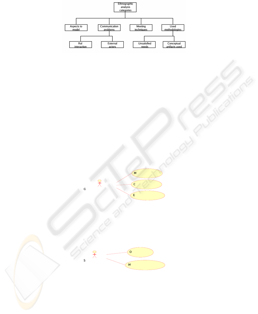
Fig.1. Analysis Categories.
– Spatial analyst:Takes the spatial layers loaded into the system and overlaps and
process them producing new information to achieve the goals of the system. Spatial
processing tools with raster and vector processing capabilities are used. Version
management tools also must be considered to organize spatial layers. Thematic
professionals interested in particular modelings are included in this group [Figure
3].
– Final user: Queries the system through a graphical interface capable of displaying
several spatial layers at different scales, overlap them and show their associated
non-spatial attributes. The user can look for a particular place in the territory or
search for a spatial segment that has a specific set of features and attributes of
interest. Decision makers mainly are in this group [Figure 4].
Fig.2. User case for geoinformation feeder.
Fig.3. User case for Spatial analyst.
172
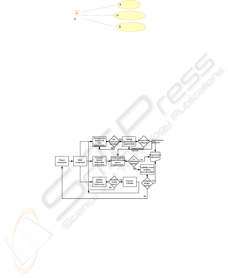
Fig.4. User case for final user.
4.3 The Process
Another result is a workflow describing the observed RE processes for GIS. As GIS ap-
plications model real world phenomena, feedback and updating of information become
a crucial issue. For this reason the normal workflow of elicitation, analysis, specification
and verification of requirements must be accompanied with a special flow taking care
of the spatial information. Availability, completeness and quality of the information is
considered in order to meet the system requirements. Budget issues are also important if
brand new information is needed. The last flow deals with integration. Existing systems
provides a cheap way to get some functionalities or spatial information impossible to
obtain from the scratch due to mainly budget issues. This 3 flows observed in [Figure
5] can occur in a parallel fashion and are key factors to model the user point of view in
data modelling, spatial database creation and integral management of the system [7].
Fig.5. GIS requirements workflow.
5 Conclusions and Future Work
Ethnography is a novel approach to the requirements engineering, taking social research
tools as a way to interact with the members of a community. Using the perspective of
a field located observer allows to acquire a complete description of this community
and their interests. Here applied to instances of work teams of the GIS community in
Colombia, has proven to be an invaluable instrument in finding hidden knowledge that
is difficult to assess with other techniques. The results obtained will be very handy
in defining a requirements engineering methodology for an specific domain as GIS.
173

The next phase, will be take the suggestions, observed behaviors and needs to propose
extensions to UML to deal with spatial features. Though there are advances in this issue
[2], they have focused in provide UML artifacts with spatial and temporal capabilities.
However there are other issues that must be covered as network analysis, metadata,
scale and three-dimensional features, ignored by the current methodologies. Once the
extensions are finished, a set of steps will be put together forming a RE-methodology
strong enough to improve the deploying of this applications that are gaining popularity
in recent years.
References
1. Andrea Aime, Flavio Bonfatti, and Paola Daniela Monari. Making gis closer to end users of
urban environment data. In GIS ’99: Proceedings of the 7th ACM international symposium
on Advances in geographic information systems, pages 122–127, New York, NY, USA, 1999.
ACM Press.
2. Silvia Gordillo and Federico Balaguer. Refining an object-oriented gis design model: topolo-
gies and field data. In GIS ’98: Proceedings of the 6th ACM international symposium on
Advances in geographic information systems, pages 76–81, New York, NY, USA, 1998. ACM
Press.
3. Rosana Guber. El salvaje metropolitano:. Reconstruccion del conocimiento social en el tra-
bajo de campo. PAIDOS, 2004.
4. Martyn Hammersley and Paul Atkinson. Etnografia. Metodos de investigacion. PAIDOS,
1995.
5. John Hughes, Val King, Tom Rodden, and Hans Anderson. The role of etnography in interac-
tive systems design. Interactions, pages 57–65, 1995.
6. IGAC. Conceptos b
´
asicos sobre Sistemas de Informaci
´
on Geogr
´
afica y aplicaciones en lati-
noamerica. Instituto Geogr
´
afico Agust
´
ın Codazzi IGAC, 1995.
7. C. P. Load and Albert K. W. Yeung. Concepts and techniques of Geographic Information
Systems. Prentice-Hall, 2002.
8. David R. Millen. Rapid ethnography: time deepening strategies for hci field research. In DIS
’00: Proceedings of the conference on Designing interactive systems, pages 280–286, New
York, NY, USA, 2000. ACM Press.
9. H. Sharp, M. Woodman, and H. Robinson. Using ethnography and discourse analysis to study
software engineering practices. 2000.
174
